
Journal of Geo-information Science >
Location Advantage of Inland River Ports in the Yangtze River Economic Belt based on Multi-Source Data
Received date: 2022-06-27
Revised date: 2022-08-15
Online published: 2022-11-25
Supported by
National Key Research and Development Program of China(2019YFB2102503)
Open Fund of Key Laboratory of Urban Land Resources Monitoring and Simulation,Ministry of Natural Resources(KF-2021-06-102)
Postgraduate Research Innovation Project of Chongqing Jiaotong University(CYS21362)
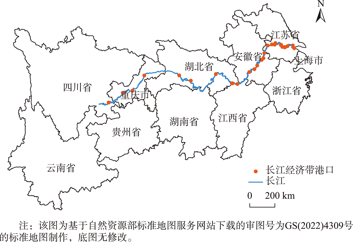
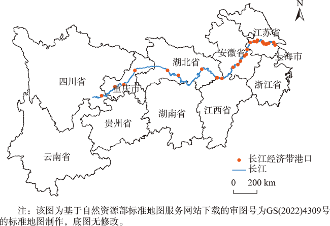
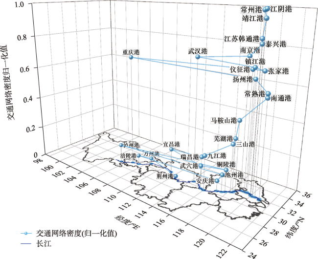
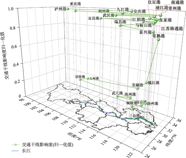
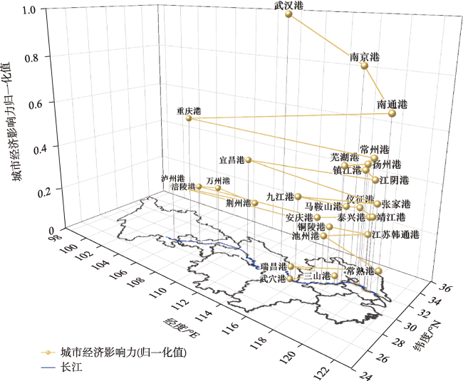
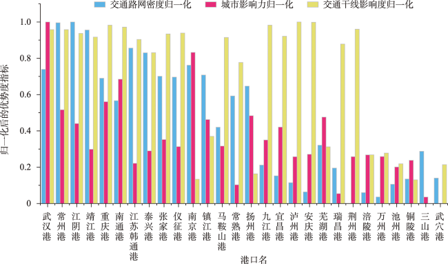
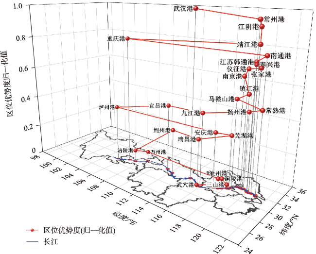
Inland river ports are important nodes of inland river shipping links. Evaluation of the regional advantage of inland river ports is of great significance for port infrastructure construction in the Yangtze River Economic Belt. Taking the inland ports along the Yangtze River in 2021 as the research object, the original model is improved by using multi-source data and combining three indicators within the radiation range of inland ports on the Yangtze River. The AHP-EWM model is used to calculate the location advantage of 28 ports along the Yangtze River in the Yangtze River economic belt. Results show that: (1) except Chongqing and Wuhan, the density of traffic network in the port radiation range beyond Jiangsu province is relatively low. From the perspective of the influence of traffic networks, its distribution is relatively balanced, and the value is relatively similar. The influence of the spatial distribution of urban economics is disordered; (2) The spatial pattern of freight ports in the Yangtze River Economic Belt is characterized by "three centers, one cluster" according to their regional advantages and spatial distribution; (3) By dividing inland ports at the provincial level along the Yangtze River, it is found that the regional difference of dominance between the three ports in Jiangxi Province is the smallest, and the overall degree of dominance is also low. The result of Anhui Province is similar to Jiangxi Province. The overall degree of dominance of ports in Jiangsu Province is high with a small regional difference. The regional dominance of ports in Hubei Province has the largest difference, indicating that there might be issues such as unbalanced infrastructure construction that needs to be improved in future. The research results can provide guidance for infrastructure construction, road traffic planning, and port site selection of various ports in the Yangtze River Economic Belt, and help open up the "last kilometer" of railway and high-grade highway access to ports.
ZOU Xinchen , MU Fengyun , WANG Junxiu , CHEN Jiankun , TIAN Tian . Location Advantage of Inland River Ports in the Yangtze River Economic Belt based on Multi-Source Data[J]. Journal of Geo-information Science, 2022 , 24(9) : 1717 -1729 . DOI: 10.12082/dqxxkx.2022.220448
表1 数据来源Tab. 1 Source of data |
| 名称 | 类型 | 年份 | 来源 | 包含字段 |
|---|---|---|---|---|
| 港口数据 | xls | 2021 | CnopenData | 经纬度、名称、类型 |
| 路网数据 | shp | 2021 | OpenStreetMap | 名称、类型 |
| 火车站数据 | xls | 2021 | 12306官网 | 经纬度、名称、类型 |
| 机场数据 | xls | 2021 | OurAirports | 经纬度、名称 |
| GDP、城镇化率 | xls | 2022 | 2022年度统计年鉴 | 通过统计年鉴自行采集 |
表3 各省份港口区位优势度差异Tab. 3 Differences in port location advantages between provinces |
| 省份/直辖市 | 货运港口数量/个 | 最大值 | 最小值 | 平均值 | 标准差 |
|---|---|---|---|---|---|
| 江苏 | 11 | 0.9572 | 0.4638 | 0.7135 | 0.1530 |
| 湖北 | 3 | 1.0000 | 0.0000 | 0.4279 | 0.5153 |
| 江西 | 3 | 0.4494 | 0.2870 | 0.3860 | 0.0860 |
| 四川 | 1 | 0.3634 | 0.3634 | 0.3634 | 0.0000 |
| 重庆 | 3 | 0.8077 | 0.0646 | 0.3167 | 0.4252 |
| 安徽 | 6 | 0.5325 | 0.0234 | 0.2238 | 0.2059 |
| [1] |
内河航运发展纲要[J]. 中国水运, 2020(6):17-19.
[Outline of inland waterway navigation development[J]. China Water Transport, 2020(6):17-19. ] DOI: 10.13646/j.cnki.42-1395/u.2020.06.007
|
| [2] |
刘玮辰, 曹有挥, 吴威, 等. 长江集装箱港口岸线利用空间格局及其对资源环境的影响[J]. 长江流域资源与环境, 2021, 30(8):1819-1828.
[
|
| [3] |
郝媛, 全波, 徐天东. 长江经济带战略背景下长江上游港口群发展[J]. 城市交通, 2018, 16(2):61-69.
[
|
| [4] |
刘涛, 刘均卫. 长江干线集装箱港口体系集中度演进分析[J]. 经济地理, 2018, 38(3):113-119.
[
|
| [5] |
梁双波, 刘玮辰, 曹有挥, 等. 长江港口岸线资源利用及其空间效应[J]. 长江流域资源与环境, 2019, 28(11):2672-2680.
[
|
| [6] |
曹有挥, 梁双波, 吴威, 等. 枢纽港口城市港航服务业空间组织机理——以上海市为例[J]. 地理学报, 2017, 72(12):2226-2240.
[
|
| [7] |
|
| [8] |
李丹. 中国沿海集装箱港口等级与效率评价研究[D]. 大连海事大学, 2015.
[
|
| [9] |
陈慧, 唐如建, 付光辉, 等. 区位优势度对南京市新建商品住宅空置率影响的实证研究[J]. 现代城市研究, 2018(11):7.
[
|
| [10] |
郭建科, 王绍博, 王辉, 等. 国家级风景名胜区区位优势度综合测评[J]. 经济地理, 2017, 37(1):187-195.
[
|
| [11] |
|
| [12] |
|
| [13] |
赵江南, 周跃. 基于“一带一路”建设的环渤海地区港口优势评价[J]. 海洋开发与管理, 2019, 36(7):83-88.
[
|
| [14] |
牟乃夏, 廖梦迪, 张恒才, 等. “海上丝绸之路”沿线重要港口区位优势度评估[J]. 地球信息科学学报, 2018, 20(5):613-622.
[
|
| [15] |
杨忍, 牟乃夏, 彭澎, 等. “海上丝绸之路”沿线重要港口竞争力评价[J]. 地球信息科学学报, 2018, 20(5):623-631.
[
|
| [16] |
|
| [17] |
|
| [18] |
|
| [19] |
|
| [20] |
祁于娜, 王磊. 层次分析-熵值定权法应用于山区城镇地质灾害易发性评价[J]. 测绘通报, 2021(6):112-116.
[
|
| [21] |
向奇韬, 徐可以, 温泉儿, 等. 基于EWM和AHP的成都高新区产城融合度测评[J]. 武汉理工大学学报(信息与管理工程版), 2020, 42(4):355-360.
[
|
| [22] |
袁瑜. 基于Nested Logit模型的内河港口经济腹地范围研究[D]. 宁波: 宁波大学, 2018.
[
|
| [23] |
王昆, 王珊, 孔宪娟, 等. 基于空间分析的区位优势度模型及其应用分析[J]. 林业调查规划, 2013, 38(2):13-19.
[
|
| [24] |
陆锋, 陈洁. 武汉城市圈城市区位与可达性分析[J]. 地理科学进展, 2008, 27(4):68-74.
[
|
| [25] |
张新, 刘海炜, 董文, 等. 省级主体功能区划的交通优势度的分析与应用——以河北省为例[J]. 地球信息科学学报, 2011, 13(2):170-176,280.
[
|
| [26] |
金凤君, 王成金, 李秀伟. 中国区域交通优势的甄别方法及应用分析[J]. 地理学报, 2008, 63(8):787-798.
[
|
| [27] |
曹克瑜. GDP指标衡量经济发展的局限性[N]. 中国社会科学院院报, 2004/04/06(3).
|
| [28] |
郭桂萍, 沈威. 城镇化与经济发展水平关系的时空演变特征研究——以长江流域为例[J]. 商业经济研究, 2018(23):138-141.
[
|
| [29] |
|
/
| 〈 |
|
〉 |