
Journal of Geo-information Science >
Applicability Analysis of Satellite-based and Reanalysis Precipitation Products in Poorly-Gauged Arid Inland Basins
Received date: 2022-06-27
Revised date: 2022-08-15
Online published: 2022-11-25
Supported by
Qinghai Department of Science and Technology(2019-SF-A4-1)
National Natural Science Foundation of China(41671026)
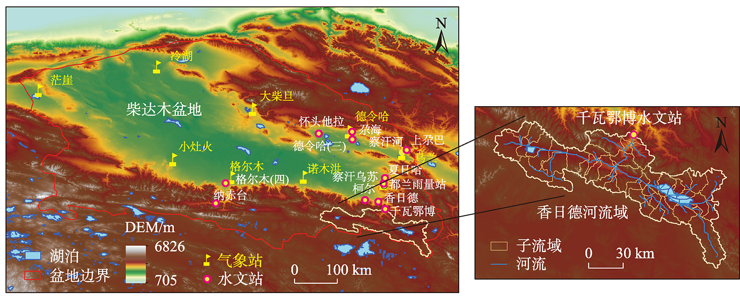
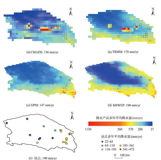
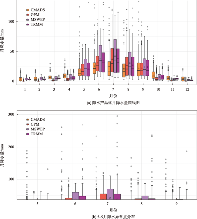
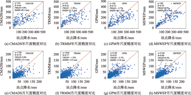
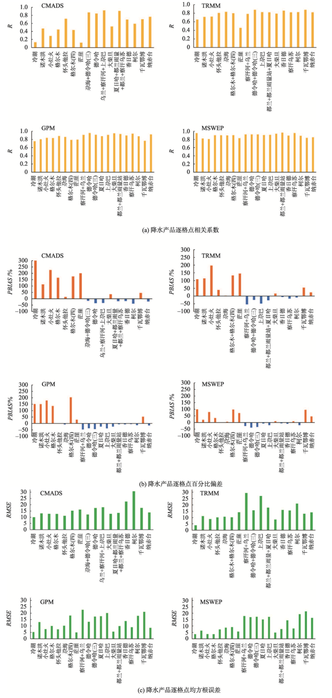
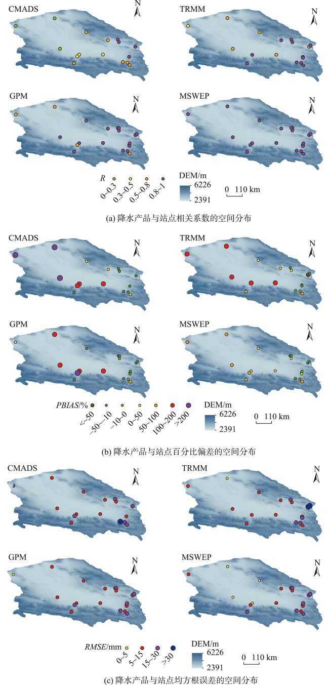
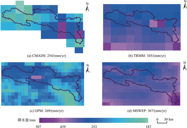
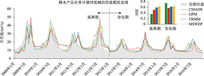
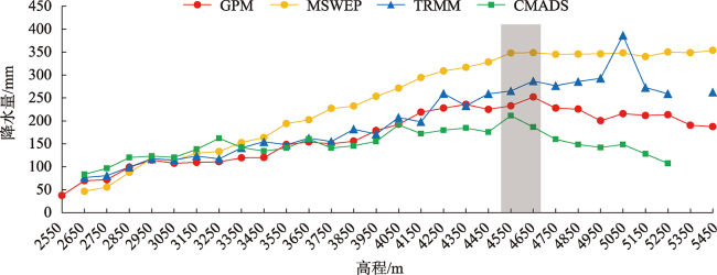
Precipitation is often concentrated in mountainous regions, but rain gauges mostly cluster in flat valleys or populated regions and thus have poor spatial and temporal consistency. Satellite-based and reanalysis precipitation products can provide precipitation data without being restricted by local terrain condition. However, these products are usually subject to systematic errors, which may vary with time and topographic condition. Thus, it is essential to evaluate and analyze the regional applicability of different precipitation products. The Qaidam Basin is one of the typical alpine arid inland basins in China. Its center part belongs to an arid desert region, and water scarcity hampers the socioeconomic development of this region. The Qaidam basin is surrounded by mountainous regions which are the “water tower” in the world with concentrated precipitation but sparse rain gauge networks. The lack of precise precipitation observation in space and time in mountainous regions can result in unreliable hydrologic modeling and unsustainable water management. To obtain accurate precipitation data, this study collected and evaluated four widely used precipitation products with higher spatiotemporal resolution, including CMADS, TRMM, GPM, and MSWEP. First, we evaluated the suitability of these four precipitation products in the Qaidam Basin against gauge-based precipitation data, using monthly precipitation data from nine meteorological stations and 13 hydrological stations. The spatiotemporal characteristics and the site level errors of the four precipitation products were also analyzed. Then, we concentrated on the typically poorly gauged basin, Xiangride River Basin located in the southeastern Qaidam Basin. The Four precipitation products were input to the semi-distributed hydrological model, Soil and Water Assessment Tool (SWAT), to evaluate the simulated streamflow by comparison with observed streamflow from the gauge data at the watershed outlet (Qianwaebo hydrological station). Results show that: (1) At yearly and monthly scales, MSWEP achieved the highest agreement (R ≥ 0.79, PBIAS = 0.5%) against the observed data, followed by GPM and TRMM, while CMADS had the worst performance (R ≥ 0.64, PBIAS = 5.8%); (2) All precipitation products generally overestimated precipitation at lower elevations and underestimated precipitation at higher elevations; (3) At the basin scale, MSWEP performed best (NSE = 0.64 vs. 0.36~0.59 for other datasets) in the baseline period (2009—2012), while CMADS performed best (NSE = 0.75 vs. 0.53~0.68 for other datasets) in the impacted period (2013—2016). This study can provide important support for obtaining accurate precipitation information and improving water resources management in poorly gauged arid mountainous region.
LV Aifeng , QI Shanshan . Applicability Analysis of Satellite-based and Reanalysis Precipitation Products in Poorly-Gauged Arid Inland Basins[J]. Journal of Geo-information Science, 2022 , 24(9) : 1817 -1834 . DOI: 10.12082/dqxxkx.2022.220356
表1 柴达木盆地地面测站基本信息Tab. 1 Basic information of gauge observations in the Qaidam Basin |
| 类别 | 站名 | 纬度/°N | 经度/°E | 海拔/m | 月均降水量/mm |
|---|---|---|---|---|---|
| 气象站 | 大柴旦 | 37.85 | 95.35 | 3179 | 8.4 |
| 德令哈 | 37.38 | 97.36 | 3001 | 19.5 | |
| 都兰 | 36.29 | 98.09 | 3185 | 20.1 | |
| 格尔木 | 36.42 | 94.90 | 2809 | 4.2 | |
| 冷湖 | 38.74 | 93.33 | 2765 | 1.8 | |
| 茫崖 | 38.25 | 90.85 | 2938 | 4.4 | |
| 诺木洪 | 36.43 | 96.42 | 2767 | 5.1 | |
| 乌兰 | 36.93 | 98.48 | 2980 | 19.6 | |
| 小灶火 | 36.80 | 93.68 | 2779 | 2.6 | |
| 水文站 | 察汗河 | 36.94 | 98.48 | 2957 | 39.3 |
| 察汗乌苏 | 36.24 | 98.11 | 3240 | 20.9 | |
| 德令哈(三) | 37.38 | 97.43 | 3025 | 21.9 | |
| 都兰雨量站 | 36.29 | 98.09 | 3194 | 21.2 | |
| 尕海 | 37.22 | 97.44 | 2860 | 13.2 | |
| 怀头他拉 | 37.34 | 96.73 | 2848 | 9.2 | |
| 上尕巴 | 36.99 | 98.57 | 3135 | 28.4 | |
| 夏日哈 | 36.40 | 98.12 | 3104 | 23.3 | |
| 香日德 | 35.91 | 97.98 | 3199 | 23.9 | |
| 纳赤台 | 35.87 | 94.57 | 3559 | 16.3 | |
| 柯尔 | 35.94 | 97.70 | 3249 | 26.3 | |
| 格尔木(四) | 36.31 | 94.78 | 2919 | 5.4 | |
| 千瓦鄂博 | 35.75 | 98.13 | 3453 | 14.0 |
表2 构建SWAT模型所需的基础地理数据及来源Tab. 2 The geographic datasets required for the SWAT model set up. |
| 数据类型 | 数据源 | 分辨率 | 获取途径 |
|---|---|---|---|
| DEM | SRTM | 90 m | http://www.gscloud.cn/ |
| 土地利用数据 | Landsat | 30 m | http://data.tpdc.ac.cn |
| 土壤类型数据 | HWSD | 1 km | http://westdc.westgis.ac.cn/ |
| 径流观测数据 | 千瓦鄂博水文站 | 月尺度(1956—2016年) | 青海省水文局 |
图8 基准期和变化期降水产品SWAT模型模拟径流与实测径流对比结果Fig. 8 SWAT model calibration against observed monthly streamflow during baseline period and impacted period |
表3 降水产品在香日德河流域基准期和变化期径流模拟最优参数Tab. 3 Optimal parameter values and model performance of precipitation products in the baseline period and impacted period |
| 基准期 | 变化期 | |||||||
|---|---|---|---|---|---|---|---|---|
| CMADS | TRMM | GPM | MSWEP | CMADS | TRMM | GPM | MSWEP | |
| CN2 | 39.45 | 69.04 | 41.46 | 38.18 | 59.60 | 63.49 | 61.64 | 35.02 |
| ESCO | 0.34 | 0.58 | 0.57 | 0.66 | 0.02 | 0.18 | 0.83 | 0.71 |
| EPCO | 0.48 | 0.61 | 0.64 | 0.58 | 0.97 | 0.16 | 0.02 | 0.73 |
| OV_N | 0.47 | 0.15 | 0.41 | 0.59 | 0.36 | 0.20 | 0.57 | 0.23 |
| CH_N2 | 0.02 | 0.47 | 0.34 | 0.32 | 0.22 | 0.20 | 0.04 | 0.31 |
| CH_K2 | 9.55 | 64.55 | 74.94 | 6.41 | 20.57 | 18.03 | 149.07 | 53.26 |
| ALPHA_BF | 1.00 | 1.00 | 0.31 | 0.09 | 1.00 | 1.00 | 0.32 | 0.99 |
| GW_DELAY | 292.36 | 499.14 | 192.72 | 448.97 | 410.04 | 499.97 | 119.52 | 499.69 |
| RCHRG_DP | 0.63 | 0.61 | 0.55 | 0.24 | 0.45 | 0.67 | 0.27 | 0.34 |
| GW_REVAP | 0.05 | 0.03 | 0.09 | 0.14 | 0.10 | 0.04 | 0.19 | 0.14 |
| GW_SPYLD | 0.20 | 0.26 | 0.16 | 0.30 | 0.11 | 0.24 | 0.35 | 0.30 |
| SOL_AWC | 0.01 | 0.02 | 0.03 | 0.02 | 0.01 | 0.03 | 0.01 | 0.02 |
| SOL_K | 52.06 | 24.38 | 43.17 | 21.39 | 27.94 | 20.85 | 32.85 | 18.87 |
| SURLAG | 3.60 | 10.06 | 5.82 | 5.04 | 7.27 | 11.11 | 3.15 | 11.49 |
| NSE | 0.35 | 0.58 | 0.51 | 0.64 | 0.75 | 0.68 | 0.53 | 0.64 |
| PBIAS/% | 0 | 0 | 0 | 0 | 0.1 | -0.1 | 0 | -0.1 |
| [1] |
|
| [2] |
|
| [3] |
|
| [4] |
|
| [5] |
彭振华, 李艳忠, 余文君, 等. 遥感降水产品在中国不同气候区的适用性研究[J]. 地球信息科学学报, 2021, 23(7):1296-1311.
[
|
| [6] |
|
| [7] |
|
| [8] |
|
| [9] |
|
| [10] |
|
| [11] |
|
| [12] |
|
| [13] |
|
| [14] |
|
| [15] |
|
| [16] |
|
| [17] |
高瑞, 穆振侠, 彭亮, 等. CFSR、ERA-Interim再分析降水数据在高寒山区径流模拟中的适用性[J]. 水电能源科学, 2017, 35(9):8-12.
[
|
| [18] |
刘俊, 刘时银, 上官冬辉, 等. CMADS、ITPCAS和TRMM 3B42 3套降水数据集在玉龙喀什河流域的适用性评价[J]. 华北水利水电大学学报(自然科学版), 2017, 38(5):28-37.
[
|
| [19] |
金鑫, 金彦香. TRMM及GPM降水数据在高寒内陆河流域的准确性评估[J]. 地球信息科学学报, 2021, 23(3):395-404.
[
|
| [20] |
|
| [21] |
|
| [22] |
汪梓彤, 李石宝, 张志友. GPM近实时降水产品在青藏高原的多尺度精度评价[J]. 人民黄河, 2021, 43(4):43-49,116.
[
|
| [23] |
|
| [24] |
李林, 申红艳, 李红梅, 等. 柴达木盆地气候变化的区域显著性及其成因研究[J]. 自然资源学报, 2015, 30(4):641-650.
[
|
| [25] |
|
| [26] |
|
| [27] |
|
| [28] |
|
| [29] |
赵安周, 王冬利, 范倩倩, 等. TRMM数据在京津冀地区干旱监测适用性研究[J]. 水资源与水工程学报, 2020, 31(2):235-242.
[
|
| [30] |
|
| [31] |
|
| [32] |
|
| [33] |
|
| [34] |
|
| [35] |
|
| [36] |
|
| [37] |
史继花. 祁连山及周边地区不同下垫面云特性变化及其影响因素[D]. 兰州: 西北师范大学, 2021.
[
|
| [38] |
|
| [39] |
|
| [40] |
|
| [41] |
|
| [42] |
|
| [43] |
|
| [44] |
黄琦, 覃光华, 王瑞敏, 等. 基于MSWEP的祁连山地区降水空间分布特性解析[J]. 水利学报, 2020, 51(2):232-244.
[
|
| [45] |
|
| [46] |
陈汉清, 鹿德凯, 周泽慧, 等. GPM降水产品评估研究综述[J]. 水资源保护, 2019, 35(1):27-34.
[
|
/
| 〈 |
|
〉 |