
Journal of Geo-information Science >
Topographic Change Detection that Considers the Spatial Autocorrelation of DEM Errors
Received date: 2022-04-20
Revised date: 2022-07-15
Online published: 2023-02-25
Supported by
Major Project of Natural Science Research of Anhui Provincial Department of Education(KJ2021ZD0130)
Chuzhou "113" Industrial Innovation Team
Natural Science Foundation of the Jiangsu Higher Education Institutions of China(22KJB170016)
National Natural Science Foundation of China(41930102)
National Natural Science Foundation of China(42171402)
Nanjing University of Information Science & Technology Research start-up fund(2022r019)
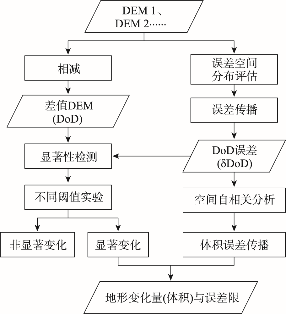
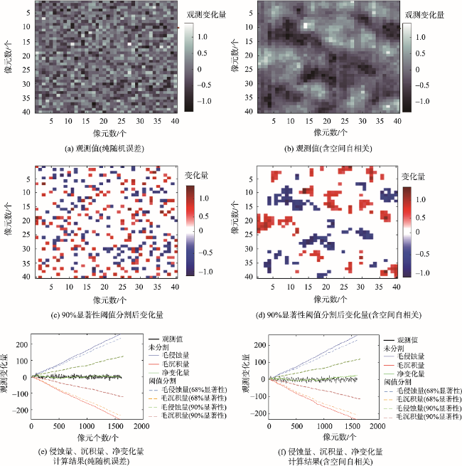
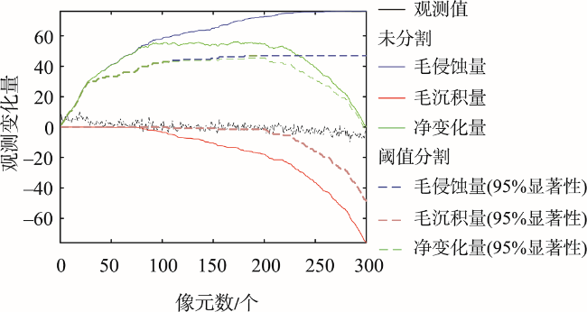
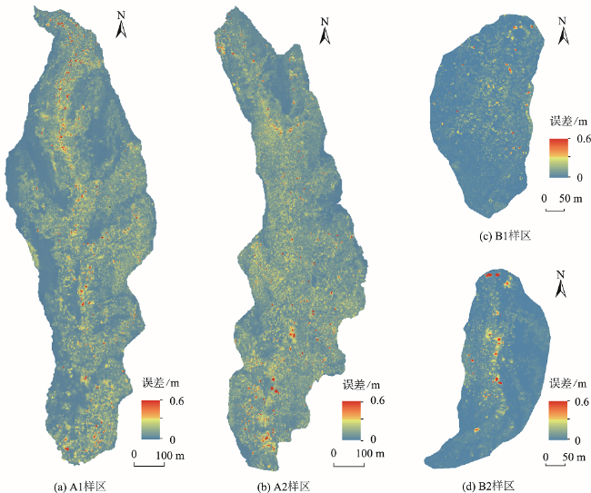
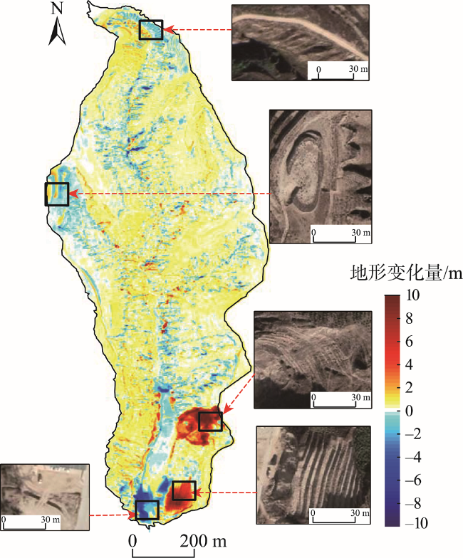
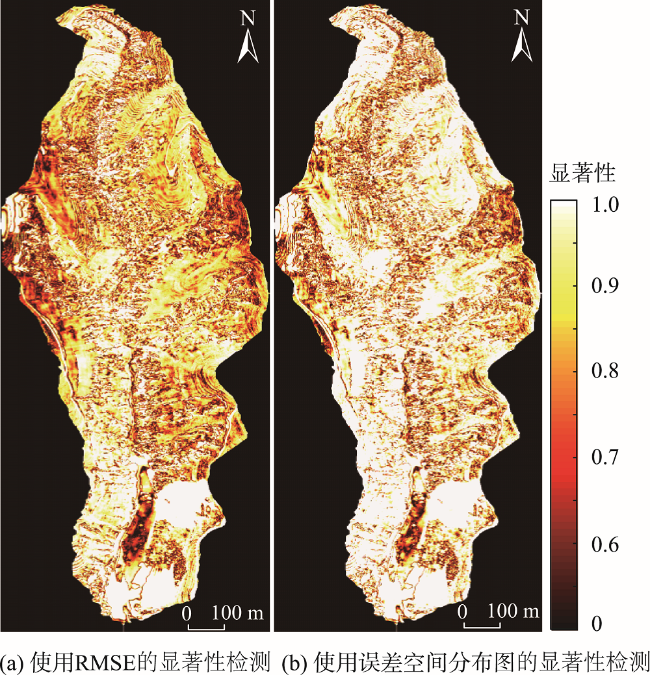
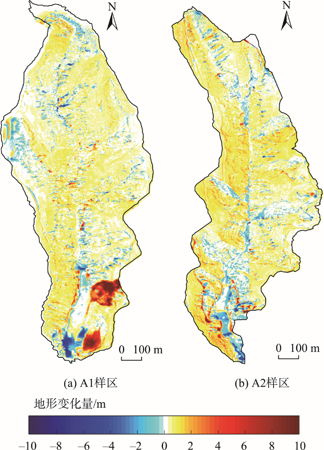
Traditional topographic change detection methods often ignore the spatial autocorrelation of DEM errors. To solve this problem, a topographic change detection method that considers the spatial autocorrelation of DEM errors is proposed in this paper. Firstly, the DEM of Difference (DoD) is obtained from two original DEMs, and the spatial distribution of DEM errors is evaluated by the Monte Carlo method. Secondly, based on spatially distributed DEM errors, DoD errors are calculated by error propagation and their spatial autocorrelation degree is analyzed using the semi-variance function. Finally, topographic changes (erosion, deposition, and net changes) are calculated based on the spatial autocorrelation analysis and significance detection. The results in four small catchments show that the elevation errors of UAV-photogrammetry DEM are spatially autocorrelated, which can be simulated by the Monte Carlo method. The use of spatially distributed error instead of RMSE for topographic change detection effectively reduces the sensitivity of the detection results to the significance threshold. When the significance threshold is increased from 68% to 95%, the loss of observations using the spatially distributed error is 5.39%~6.75% lower than that using the RMSE. The proposed method can be effectively used in the fields of surface deformation monitoring, erosion monitoring, sediment transport assessment, and so on.
DAI Wen , CHEN Kai , WANG Chun , LI Min , TAO Yu . Topographic Change Detection that Considers the Spatial Autocorrelation of DEM Errors[J]. Journal of Geo-information Science, 2022 , 24(12) : 2297 -2308 . DOI: 10.12082/dqxxkx.2022.220209
表1 误差模拟实验Tab. 1 Error simulation experiment |
| 真实变化量 | 误差特征 | 观测数 | |
|---|---|---|---|
| 无地形变化组 | 0 | 正态分布 u=0 σ=0.4 | 40×40 |
| 净侵蚀组 | 1 | ||
| 净沉积组 | -1 | ||
| 混合变化组 | -1 ~ 1 | 300 |
表2 不同条件下地形净变化量观测值Tab. 2 Observations of net topographic change under different conditions |
| 真实值 | 观测值(无分割) | 观测值(显著性阈值分割) | |
|---|---|---|---|
| 无变化组 | 0 | 2.65±16 | 1.75±16(68%) |
| 净侵蚀组 | 1600 | 1602.65±16 | 1498.28±16(95%) |
| 净沉积组 | -1600 | -1597.34±16 | -1460.70±16(95%) |
表3 地形混合变化下侵蚀量、沉积量和净变化量观测值Tab. 3 Observations of erosion, deposition and net change under mixed topographic changes |
| 真实值 | 观测值(无分割) | 观测值(95%显著性分割) | |
|---|---|---|---|
| 毛侵蚀 | 50 | 76.18±4.89 | 46.9±4.89 |
| 毛沉积 | -50 | -76.03±4.89 | -46.17±4.89 |
| 净变化 | 0 | 0.15±6.92 | -0.72±6.92 |
表4 不同检测方式下检测的地形变化面积Tab. 4 Detected topographic change areas under different detection methods (%) |
| 样区 | 中误差检测 | 误差空间分布图检测 | |||||
|---|---|---|---|---|---|---|---|
| 68%显著性 | 95%显著性 | 下降程度 | 68%显著性 | 95%显著性 | 下降程度 | ||
| A1 | 82.46 | 61.26 | 21.20 | 87.12 | 74.35 | 12.77 | |
| A2 | 84.74 | 67.53 | 17.21 | 88.26 | 76.45 | 11.82 | |
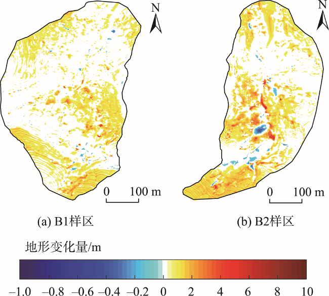
| B1 | 57.41 | 20.69 | 36.72 | 66.27 | 36.30 | 29.97 | |
| B2 | 57.72 | 27.14 | 30.58 | 63.95 | 35.95 | 28.00 | |
表5 实测小流域地形变化量及输沙率Tab. 5 Measured topographic variation and sediment transport rate of small watershed |
| 样区 | 毛侵蚀量/t(误差) | 毛沉积量/t(误差) | 净变化量/t(误差) | 输沙率/(t/yr)(误差) | 输沙率相对误差/% |
|---|---|---|---|---|---|
| A1 | 210 709.34 | -41 395.90 | 169 313.44 | 12 093.82 | 6.62 |
| (±10 173.24) | (±4703.33) | (±11 207.86) | (±800.56) | ||
| A2 | 215 870.70 | -43088.44 | 172 782.26 | 12 341.59 | 6.24 |
| (±9685.18) | (±4733.91) | (±10 780.20) | (±770.01) | ||
| B1 | 15 523.22 | -964.96 | 14 558.26 | 2911.65 | 26.50 |
| (±3589.14) | (±1415.46) | (±3858.16) | (±771.63) | ||
| B2 | 14 642.17 | -3547.07 | 11 095.11 | 2219.02 | 29.96 |
| (±3196.08) | (±912.49) | (±3323.79) | (±664.76) |
| [1] |
贺礼家, 冯光财, 冯志雄, 等. 哨兵-2号光学影像地表形变监测:以2016年MW7.8新西兰凯库拉地震为例[J]. 测绘学报, 2019, 48(3):339-351.
[
|
| [2] |
代文, 汤国安, 胡光辉, 等. 基于无人机摄影测量的地形变化检测方法与小流域输沙模型研究[J]. 地理科学进展, 2021, 40(9):1570-1580.
[
|
| [3] |
李德仁, 夏松, 江万寿, 等. 一种地形变化检测与DEM更新的方法研究[J]. 武汉大学学报·信息科学版, 2006, 31(7):565-568.
[
|
| [4] |
|
| [5] |
张绍成, 殷飞, 明祖涛, 等. 先验形变约束的实时动态载波相位差分变形监测[J]. 测绘科学, 2020, 45(11):8-12.
[
|
| [6] |
李治洪. GNSS系统在黄金峡坝肩边坡变形监测中的应用[J]. 人民黄河, 2021, 43(1):125-128.
[
|
| [7] |
李瑞峰, 常乐, 秦海. InSAR监测技术与水准测量技术对比研究[J]. 工程质量, 2021, 39(3):72-76.
[
|
| [8] |
郭保. GPS技术在水库大坝变形监测中的应用[J]. 测绘与空间地理信息, 2020, 43(12):103-106.
[
|
| [9] |
殷硕文, 邵茜. 基于地形匹配的InSAR地形变化检测方法研究[J]. 武汉大学学报·信息科学版, 2010, 35(1):118-121.
[
|
| [10] |
|
| [11] |
董雅竹, 谭颖, 张朋辉, 等. 利用PS-InSAR研究合肥地区活动构造变形[J]. 地球物理学进展, 2021, 36(5):1822-1833.
[
|
| [12] |
|
| [13] |
许强, 蒲川豪, 赵宽耀, 等. 延安新区地面沉降时空演化特征时序InSAR监测与分析[J]. 武汉大学学报·信息科学版, 2021, 46(7):957-969.
[
|
| [14] |
|
| [15] |
郭延辉, 杨溢, 杨志全, 等. 国产GB-InSAR在特大型水库滑坡变形监测中的应用[J]. 中国地质灾害与防治学报, 2021, 32(2):66-72.
[
|
| [16] |
孙建宝, 梁芳, 沈正康, 等. 汶川MS8.0地震InSAR形变观测及初步分析[J]. 地震地质, 2008, 30(3):789-795.
[
|
| [17] |
|
| [18] |
曹敏, 汤国安, 张芳, 等. 基于元胞自动机的黄土小流域地形演变模拟[J]. 农业工程学报, 2012, 28(22):149-155,294.
[
|
| [19] |
王清. 数字地形分析中表面积与体积计算的不确定性建模与分析[D]. 武汉: 华中师范大学, 2016.
[
|
| [20] |
|
| [21] |
|
| [22] |
|
| [23] |
|
| [24] |
|
| [25] |
|
| [26] |
舒彦军, 张立亭. 求解半变异函数的常用方法与新方法研究[J]. 测绘与空间地理信息, 2012, 35(5):24-27.
[
|
| [27] |
|
| [28] |
|
| [29] |
高海东. 黄土高原丘陵沟壑区沟道治理工程的生态水文效应研究[D]. 北京: 中国科学院研究生院(教育部水土保持与生态环境研究中心), 2013.
[
|
/
| 〈 |
|
〉 |
