
Journal of Geo-information Science >
Assessment and Analysis of the 2020 Poyang Lake Flood Hazard based on Optical and Radar Image Assisted Change Detection
Received date: 2022-04-13
Revised date: 2022-06-28
Online published: 2023-02-25
Supported by
National Natural Science Foundation of China(31971639)
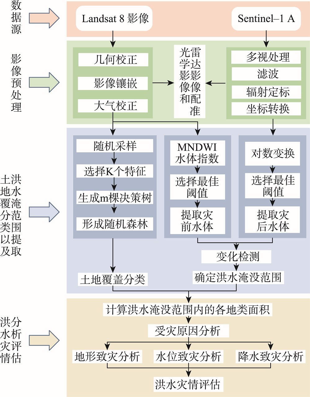
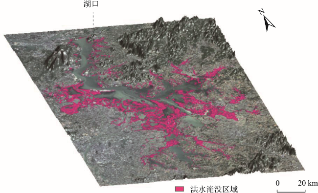
In the summer of 2020, heavy rains made the Poyang Lake region witnessed a big flood event. Remote sensing earth observation technology can help to map and assess the flood hazard quickly and efficiently. Therefore, two 2020 satellite images acquired on April 15 (Landsat-8 OLI) and July 14 (Sentinel-1A SAR) were selected in this study to represent the dates before and after the flood to evaluate the disaster. Using remote sensing thematic information extraction, Random Forest classification and change detection technology, the inundation area and the area of major land cover types within the inundation areas were revealed. Associated with the hydrological, meteorological and topographical data, the specific flooded sites and the factors causing the disaster were identified and analyzed. The results show that the flood-inundation extent in the Poyang Lake region in 2020 is 1961.95 km², including 760.54 km² of farmland, 71.59 km² of forest, 992.02 km² of grassland, 26.97 km² of soil, and 110.83 km² of built-up land. Poyang County was most severely affected in this flood event, with a total inundated area of 514.35 km². The next two are Xinjian County with 330 km² and Yugan County with 310 km². The main hydro-meteorological and topographical factors that caused the flood are considered to be: (1) higher water level than that in the 1998 flood; (2) failure of timely discharge of water due to backflow of the Yangtze River; (3) breach of the embankments.
Key words: Poyang Lake; flood; disaster analysis; Landsat 8; Sentinel-1A; remote sensing; land cover; precipitation
DUAN Weifang , WEN Xiaole , XU Hanqiu , DENG Wenhui . Assessment and Analysis of the 2020 Poyang Lake Flood Hazard based on Optical and Radar Image Assisted Change Detection[J]. Journal of Geo-information Science, 2022 , 24(12) : 2435 -2447 . DOI: 10.12082/dqxxkx.2022.220184
表1 训练样本分离性指标Tab.1 Separability of training samples |
| 耕地 | 森林 | 草地 | 建筑用地 | 裸地 | |
|---|---|---|---|---|---|
| 耕地 | - | 1.99 | 1.96 | 1.89 | 1.92 |
| 森林 | 1.99 | - | 1.83 | 1.99 | 1.99 |
| 草地 | 1.96 | 1.83 | - | 1.99 | 1.99 |
| 建筑用地 | 1.89 | 1.99 | 1.99 | - | 1.85 |
| 裸地 | 1.92 | 1.99 | 1.99 | 1.85 | - |
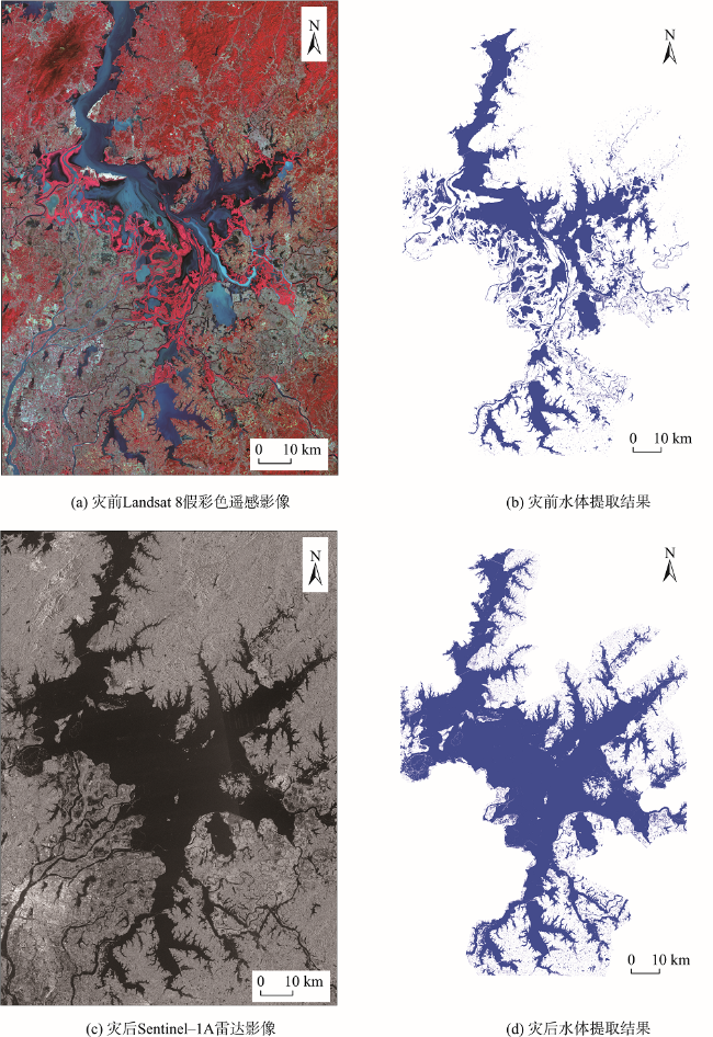
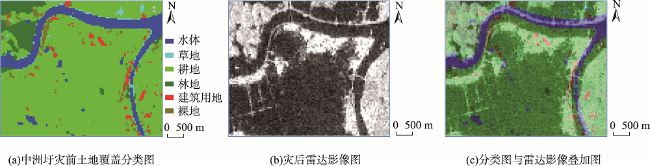
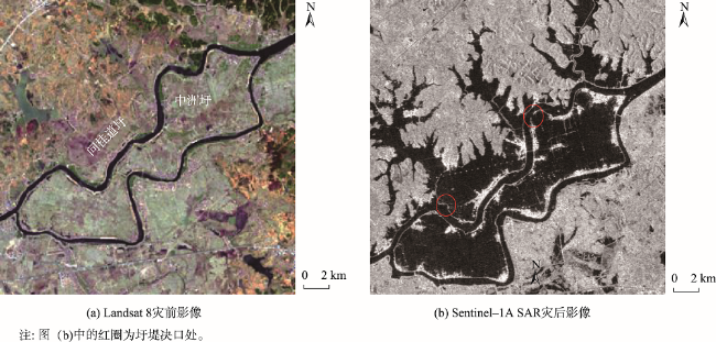
图4 2020年鄱阳湖灾前灾后影像及其水体提取Fig. 4 Remote sensing images and the corresponding water maps of the Poyang Lake area before and after the 2020 flood |
表2 洪水淹没范围地物分类精度验证结果Tab.2 Accuracy assessment of the land cover classification in the flooded area |
| 验证数据 | 行像元总计 /个 | 使用者精度/% | |||||
|---|---|---|---|---|---|---|---|
| 草地 | 耕地 | 建筑用地 | 裸地 | 森林 | |||
| 草地 | 91 | 6 | 1 | 0 | 2 | 100 | 91.00 |
| 耕地 | 6 | 132 | 5 | 1 | 1 | 145 | 91.03 |
| 建筑用地 | 0 | 0 | 68 | 1 | 1 | 70 | 97.14 |
| 裸地 | 0 | 4 | 0 | 41 | 0 | 45 | 91.11 |
| 森林 | 2 | 7 | 1 | 0 | 40 | 50 | 80.00 |
| 列像元总计/个 | 99 | 149 | 75 | 43 | 44 | 410 | |
| 生产者精度/% | 91.92 | 88.59 | 90.67 | 95.35 | 90.09 | ||
| 总精度 = 90.73% Kappa = 0.8777 | |||||||
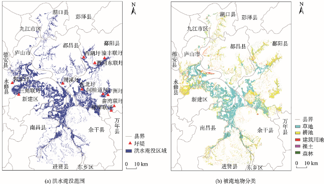
表3 鄱阳湖周边各县(市、区)洪水淹没地类面积Tab.3 Statistics of the inundated area in the counties surrounding the Poyang Lake |
| 地名 | 耕地被淹面积/km2 | 林地被淹面积/km2 | 建筑被淹面积/km2 | 草地被淹面积/km2 | 裸地被淹面积/km2 | 被淹总面积/km2 |
|---|---|---|---|---|---|---|
| 南昌县 | 42.17 | 3.34 | 6.84 | 53.31 | 0.32 | 105.98 |
| 新建区 | 53.45 | 4.36 | 11.10 | 261.08 | 0.08 | 330.07 |
| 进贤县 | 60.71 | 12.55 | 9.80 | 56.13 | 3.71 | 142.90 |
| 永修县 | 101.07 | 3.22 | 20.10 | 88.06 | 0.26 | 212.71 |
| 都昌县 | 94.86 | 8.25 | 15.65 | 40.60 | 4.70 | 164.06 |
| 庐山市 | 31.52 | 1.47 | 7.65 | 63.41 | 0.07 | 104.12 |
| 德安县 | 0.26 | 0.00 | 0.12 | 0.02 | 0.00 | 0.40 |
| 湖口县 | 32.84 | 5.75 | 5.89 | 13.43 | 0.13 | 58.04 |
| 九江市区 | 4.06 | 0.43 | 0.16 | 2.41 | 0.00 | 7.06 |
| 鄱阳县 | 260.63 | 20.50 | 21.60 | 198.11 | 13.51 | 514.35 |
| 余干县 | 70.03 | 10.72 | 11.41 | 214.87 | 3.42 | 310.45 |
| 万年县 | 6.34 | 0.29 | 0.41 | 0.21 | 0.70 | 7.95 |
| 东乡区 | 2.60 | 0.71 | 0.10 | 0.38 | 0.07 | 3.86 |
| 总计/km2 | 760.54 | 71.59 | 110.83 | 992.02 | 26.97 | 1961.95 |
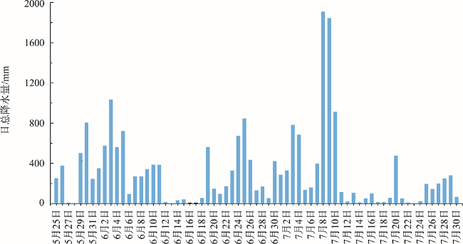
表4 1998年和2020年汛期降雨量对比Tab.4 Comparison of precipitation in the flood seasons in 1998 and 2020 |
| 流域名称 | 1998年6月12—27日、7月17—26日 | 2020年6月16日—7月10日 | |||||
|---|---|---|---|---|---|---|---|
| 累积降水量/mm | 历史同期均值/mm | 比值 | 累积降水量/mm | 历史同期均值/mm | 比值 | ||
| 饶河 | 2751.70 | 483.60 | 5.69 | 1724.30 | 444.75 | 3.88 | |
| 修水 | 1788.88 | 336.04 | 5.32 | 956.00 | 276.36 | 3.46 | |
| 赣江 | 6339.86 | 1683.97 | 3.76 | 5042.90 | 1667.51 | 3.02 | |
| 信江 | 3444.97 | 563.75 | 6.11 | 1762.20 | 476.28 | 3.70 | |
| 抚河 | 1823.50 | 460.28 | 3.96 | 763.60 | 403.38 | 1.89 | |
| 湖区 | 1524.00 | 313.89 | 4.86 | 1159.30 | 332.52 | 3.49 | |
表5 1998年、2020年研究区水文站水位数据对比Tab.5 Water-level comparison of the regional hydrological stations between 1998 and 2020 |
| 序号 | 河名 | 站名 | 最高水位/m | |
|---|---|---|---|---|
| 1998年 | 2020年 | |||
| 1 | 鄱阳湖 | 湖口 | 22.59 | 22.49 |
| 2 | 鄱阳湖 | 都昌 | 22.43 | 22.42 |
| 3 | 鄱阳湖 | 星子 | 22.52 | 22.63 |
| 4 | 鄱阳湖 | 康山 | 22.43 | 22.51 |
| 5 | 鄱阳湖 | 棠荫 | 22.57 | 22.58 |
| 6 | 昌江 | 古县渡 | 23.18 | 23.43 |
| 7 | 饶河 | 鄱阳 | 22.61 | 22.75 |
| 8 | 修河 | 永修 | 23.48 | 23.63 |
表6 鄱阳湖南北部平坦地区高程对比Tab. 6 Comparison of the elevation of the flat areas between southern and northern Poyang Lake region |
| 地名 | 平均高程/m | |
|---|---|---|
| 鄱阳湖北部 | 九江市区 | 67.63 |
| 湖口县 | 30.33 | |
| 都昌县 | 40.25 | |
| 庐山市 | 40.03 | |
| 鄱阳湖南部 | 鄱阳县南部 | 26.32 |
| 新建区 | 19.61 | |
| 南昌县 | 18.97 | |
| 余干县 | 28.26 | |
| 进贤县 | 27.59 |
| [1] |
李加林, 曹罗丹, 浦瑞良. 洪涝灾害遥感监测评估研究综述[J]. 水利学报, 2014, 45(3):253-260.
[
|
| [2] |
|
| [3] |
|
| [4] |
毛先成, 熊靓辉, 高岛·勋. 基于MOS-1b/MESSR的洪灾遥感监测[J]. 遥感技术与应用, 2007, 22(6):685-689.
[
|
| [5] |
|
| [6] |
|
| [7] |
周超, 方秀琴, 吴小君, 等. 基于三种机器学习算法的山洪灾害风险评价[J]. 地球信息科学学报, 2019, 21(11):1679-1688.
[
|
| [8] |
彭定志, 郭生练, 黄玉芳, 等. 基于MODIS和GIS的洪灾监测评估系统[J]. 武汉大学学报(工学版), 2004, 37(4):7-10,31.
[
|
| [9] |
姚仕明, 雷文韬, 渠庚, 等. 基于遥感影像的鄱阳湖2020年汛期灾情分析[J]. 人民长江, 2020, 51(12):185-190.
[
|
| [10] |
闵骞, 汪泽培. 鄱阳湖近五百年较大洪水出现规律的初步分析[J]. 江西水利科技, 1992, 18(1):76-83.
[
|
| [11] |
童庆禧. 遥感在1998年洪水监测中的作用[J]. 气候与环境研究, 1998, 3(4):27-35.
[
|
| [12] |
黄淑娥, 王保生, 张建萍, 等. 江西98特大洪涝卫星遥感监测及鄱阳湖水体淹没模型的研究[J]. 江西农业大学学报, 1999, 21(2):245-248.
[
|
| [13] |
|
| [14] |
雷声. 2020年鄱阳湖洪水回顾与思考[J]. 水资源保护, 2021, 37(6):7-12.
[
|
| [15] |
吕素娜, 薛思涵, 谢婷, 等. 哨兵一号SAR数据在鄱阳湖洪涝灾害监测中的应用[J]. 卫星应用, 2021(8):51-55.
[
|
| [16] |
李磊, 崔倩, 张志新, 等. 基于GF-3的2020年鄱阳湖洪水动态监测与影响评价[J/OL]. 水文:1-5[2022-06-21].
[
|
| [17] |
|
| [18] |
杨巧言. 江西省自然地理志[M]. 北京: 方志出版社, 2003.
[
|
| [19] |
|
| [20] |
徐涵秋. 基于影像的Landsat TM/ETM+数据正规化技术[J]. 武汉大学学报·信息科学版, 2007, 32(1):62-66.
[
|
| [21] |
徐涵秋. 新型Landsat8卫星影像的反射率和地表温度反演[J]. 地球物理学报, 2015, 58(3):741-747.
[
|
| [22] |
|
| [23] |
|
| [24] |
陶满意, 纪鹏, 黄源宝, 等. 星载SAR辐射定标及其精度分析[J]. 中国空间科学技术, 2015, 35(5):64-70.
[
|
| [25] |
|
| [26] |
|
| [27] |
贾诗超, 薛东剑, 李成绕, 等. 基于Sentinel-1数据的水体信息提取方法研究[J]. 人民长江, 2019, 50(2):213-217.
[
|
| [28] |
刘毅, 杜培军, 郑辉, 等. 基于随机森林的国产小卫星遥感影像分类研究[J]. 测绘科学, 2012, 37(4):194-196.
[
|
| [29] |
宁晓刚, 常文涛, 王浩, 等. 联合GEE与多源遥感数据的黑龙江流域沼泽湿地信息提取[J]. 遥感学报, 2022, 26(2):386-396.
[
|
| [30] |
万菁, 张阳, 郭文峰. 鄱阳湖发生倒灌[R/OL].(2020-07-07). http://slt.jiangxi.gov.cn/art/2020/7/7/art_28108_2493239.html.
[
|
| [31] |
李英, 涂安国, 胡根华, 等. 鄱阳湖流域降水量变化对水沙演变影响研究[J]. 中国水土保持, 2012(4):25-28,68.
[
|
| [32] |
许小华, 黄萍, 黄诗峰, 等. 鄱阳湖洪涝灾害卫星雷达遥感应急监测应用[J]. 中国防汛抗旱, 2021, 31(4):10-14.
[
|
/
| 〈 |
|
〉 |
