
Journal of Geo-information Science >
A Potential Gully Debris Flows Hazard Assessment Method: A CNN Model based on Multi-source Data Fusion
Received date: 2022-07-14
Revised date: 2022-08-22
Online published: 2023-04-19
Supported by
National Natural Science Foundation of China(61966040)
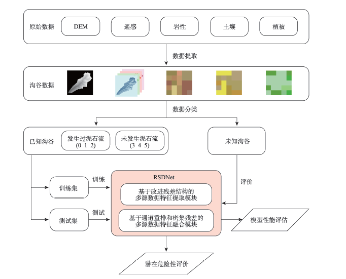
Gully debris flows frequently occur in mountainous regions. Hazard investigation in large area is always hampered by the rugged mountains. In this paper, a convolutional neural network named Residual-Shuffle-Dense residual Net (RSDNet) based on remote sensing, DEM, soil, lithology, and vegetation data was proposed to conduct large-scale territorial surveys. First, shallow features were extracted by modified residual structure using maximize pooling. Then, feature fusion was conducted to strengthen the correlation between the underlying features of various data. Next, dense residual structure was applied to make further feature extraction from underlying features and identify the impact of interaction between various features on potential debris flow hazard. Finally, the potential hazard level of a valley was given. During the training process, a joint loss function based on cross entropy loss and modified focal loss was used to make the model better distinguish the morphological and disaster-causing characteristics of various valleys. In this study, the valley classification achieved a precision rate of 0.92 by using RSDNet. In the potential hazard assessment of all valleys in Nujiang Prefecture, 122 out of 132 historical debris flow valleys were judged to be dangerous or very dangerous. Results indicate that the proposed model performs well, and this work would offer new ideas for potential debris flows hazard assessment.

XU Fanshu , WANG Baoyun , HAN Jun . A Potential Gully Debris Flows Hazard Assessment Method: A CNN Model based on Multi-source Data Fusion[J]. Journal of Geo-information Science, 2023 , 25(3) : 588 -605 . DOI: 10.12082/dqxxkx.2023.220514
表1 研究区已知沟谷K-means分类结果Tab. 1 Classification results of known valleys by K-means |
| 所属类别 | 类别编号 | 条数/条 | 高程差/km | 主沟长度/km | 流域面积/km2 |
|---|---|---|---|---|---|
| 正样本 | 0 | 51 | (1.1, 2.9) | (2.3, 15.4) | (1.0, 24.0) |
| 1 | 22 | (1.5, 3.2) | (9.8, 18.8) | (26.0, 64.0) | |
| 2 | 9 | (2.5, 3.1) | (18.0, 27.0) | (69.0, 95.1) | |
| 负样本 | 3 | 42 | (0.3, 2.4) | (2.3, 7.1) | (1.0, 7.4) |
| 4 | 29 | (0.7, 2.9) | (4.9, 15.6) | (7.5, 19.2) | |
| 5 | 14 | (1.3, 3.2) | (9.1, 16.9) | (21.7, 46.0) |
表2 各模型性能指标Tab. 2 Experiment result of different model |
| 网络名称 | OA/% | AA/% | P/% | R/% | kappa |
|---|---|---|---|---|---|
| RSDNet | 84.7 | 83.6 | 89.7 | 80.6 | 0.82 |
| ResNet18[23] | 74.7 | 74.6 | 76.8 | 74.8 | 0.71 |
| ResNet34[23] | 72.7 | 72.9 | 72.8 | 77.1 | 0.67 |
| ShuffleNet[20] | 72.9 | 73.0 | 73.3 | 74.5 | 0.68 |
| DenseNet[21] | 76.2 | 77.1 | 75.7 | 76.6 | 0.72 |
| ResNext[32] | 75.0 | 74.2 | 76.4 | 77.2 | 0.70 |
| MobileNet[33] | 70.3 | 74.4 | 75.1 | 69.5 | 0.69 |
| EfficientNet[34] | 70.7 | 70.2 | 77.4 | 71.5 | 0.66 |
| InceptionV1[35] | 73.3 | 73.5 | 72.9 | 75.0 | 0.68 |
表3 RSDNet对东月各沟谷的潜在危险性评价结果Tab. 3 Potential hazard assessment result of Dong yuege valley by RSDNet |
| 类别 | 0 | 1 | 2 | 3 | 4 | 5 | S |
|---|---|---|---|---|---|---|---|
| 相似度( ) | 0.001 | 0.489 | 0.503 | 0.0 | 0.0 | 0.07 | 0.993 |
| [1] |
刘传正. 中国崩塌滑坡泥石流灾害成因类型[J]. 地质论评, 2014, 60(4):858-868.
[
|
| [2] |
程维明, 夏遥, 曹玉尧, 等. 区域泥石流孕灾环境危险性评价——以北京军都山区为例[J]. 地理研究, 2013, 32(4):595-606.
[
|
| [3] |
魏斌斌, 赵其华, 韩刚, 等. 基于灰色关联法的地震灾区泥石流危险性评价——以北川县泥石流为例[J]. 工程地质学报, 2013, 21(4):525-533.
[
|
| [4] |
任光明, 张涛. 基于层次分析法与可拓法的新疆某泥石流危险性评价[J]. 水电能源科学, 2013, 31(9):144-147.
[
|
| [5] |
杨涛, 唐川, 朱金勇, 等. 四川省汶川县绵虒镇小流域泥石流危险性评价[J]. 长江科学院院报, 2018, 35(10):82-87.
[
|
| [6] |
王毅, 唐川, 李为乐, 等. 基于GIS的模糊数学模型在泥石流敏感性评价中的应用[J]. 自然灾害学报, 2017, 26(1):19-26.
[
|
| [7] |
张浩韦, 刘福臻, 王军朝, 等. 基于FLO-2D数值模拟的工布江达县城泥石流灾害危险性评价[J]. 地质力学学报, 2022, 28(2):306-318.
[
|
| [8] |
乔渊, 刘铁骥, 陈亮, 等. 基于Massflow模型的甘肃省岷县二马沟泥石流危险性评价[J]. 水利水电技术, 2020, 51(4):184-192.
[
|
| [9] |
|
| [10] |
|
| [11] |
|
| [12] |
陈刚, 何政伟, 杨斌, 等. 遗传BP神经网络在泥石流危险性评价中的应用[J]. 计算机工程与应用, 2010, 46(3):228-231.
[
|
| [13] |
李秀珍, 孔纪名, 李朝凤. 多分类支持向量机在泥石流危险性区划中的应用[J]. 水土保持通报, 2010, 30(5):128-133,157.
[
|
| [14] |
刘永垚, 第宝锋, 詹宇, 等. 基于随机森林模型的泥石流易发性评价——以汶川地震重灾区为例[J]. 山地学报, 2018, 36(5):765-773.
[
|
| [15] |
刘佳, 伍宇明, 高星, 等. 基于GEE和U-net模型的同震滑坡识别方法[J]. 地球信息科学学报, 2022, 24(7):1275-1285.
[
|
| [16] |
武雪玲, 杨经宇, 牛瑞卿. 一种结合SMOTE和卷积神经网络的滑坡易发性评价方法[J]. 武汉大学学报·信息科学版, 2020, 45(8):1223-1232.
[
|
| [17] |
|
| [18] |
|
| [19] |
位栋梁, 王延伟, 王自法, 等. 基于卷积神经网络的地震震级快速估算方法[J]. 地震学报, 2022, 44(2):316-326.
[
|
| [20] |
|
| [21] |
|
| [22] |
|
| [23] |
|
| [24] |
樊辉, 何大明. 怒江流域气候特征及其变化趋势[J]. 地理学报, 2012, 67(5):621-630.
[
|
| [25] |
李益敏, 谢亚亚, 蒋德明, 等. 怒江州斜坡地质灾害孕灾环境因素敏感性研究[J]. 水土保持研究, 2018, 25(5):300-305.
[
|
| [26] |
阳友奎, 周迎庆, 姜瑞琪. 坡面地质灾害柔性防护的理论与实践[M]. 北京: 科学出版社, 2005.
[
|
| [27] |
朱渊, 余斌, 亓星, 等. 地形条件对泥石流发育的影响——以岷江流域上游为例[J]. 吉林大学学报(地球科学版), 2014, 44(1):268-277.
[
|
| [28] |
|
| [29] |
姚振国, 刘建周, 牛贝贝, 等. 流域面积对沟道泥石流发育的影响分析[J]. 资源环境与工程, 2019, 33(2):217-219.
[
|
| [30] |
胡凯衡, 游勇, 庄建琦, 等. 北川地震重灾区泥石流特征与减灾对策[J]. 地理科学, 2010, 30(4):566-570.
[
|
| [31] |
|
| [32] |
|
| [33] |
|
| [34] |
|
| [35] |
|
| [36] |
唐邦兴, 周必凡, 吴积善, 等. 中国泥石流[M]. 北京: 商务印书馆, 2000.
[
|
| [37] |
|
| [38] |
|
/
| 〈 |
|
〉 |