
Journal of Geo-information Science >
Quantitative Analysis and Spatial Differentiation of Terrain based on Terrain Music: Example of Loess Plateau in Northern Shaanxi
Received date: 2022-11-17
Revised date: 2023-01-22
Online published: 2023-04-27
Supported by
Foundation item: National Natural Science Foundation of China(41171267)
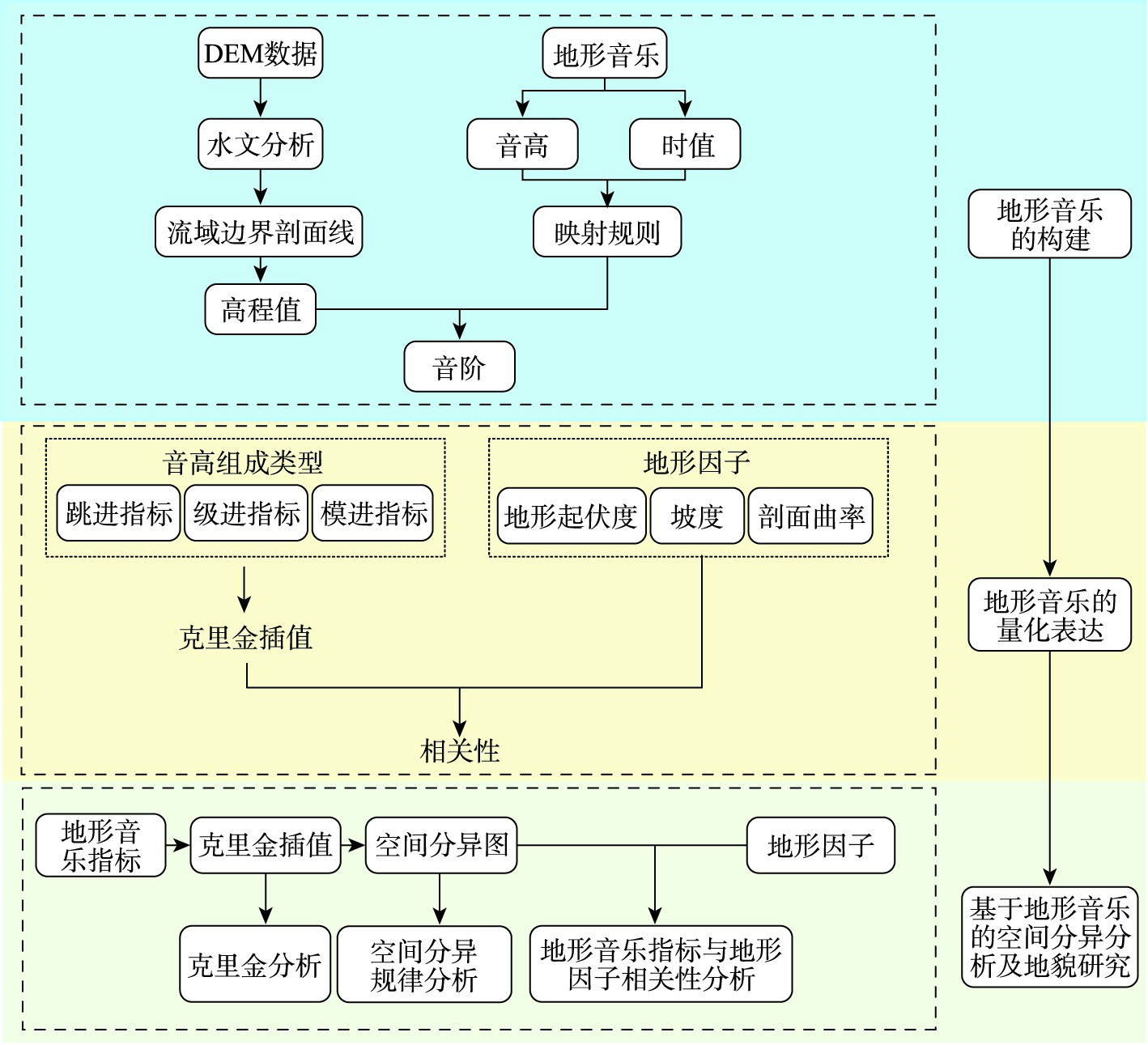
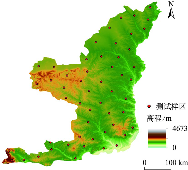
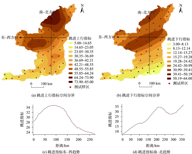
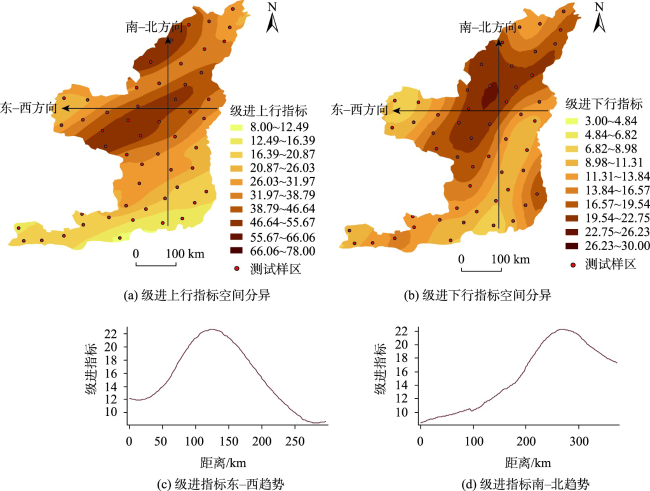
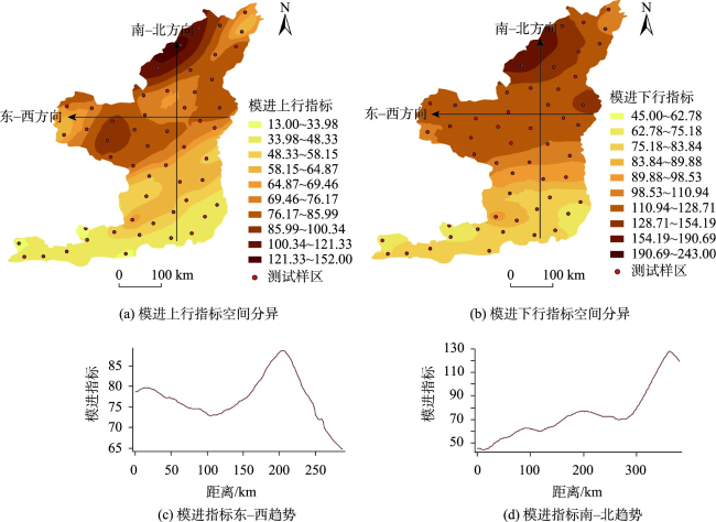
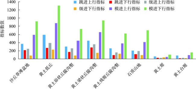
Terrain music, the study of terrain feature lines, describes terrain undulation patterns in audible form. This paper takes terrain music as the starting point to simulate and quantify the morphology of terrain characteristic lines, and further discusses the spatial differentiation characteristics and laws of the terrain on the Loess Plateau. Based on the DEM data with a resolution of 30 m, 53 typical watersheds evenly distributed on the Loess Plateau in northern Shaanxi were selected as test sample areas, and the music theory knowledge, digital terrain analysis, and geostatistical theory were integrated. The watershed boundary profile was taken as the entry point to realize the digital expression of the land surface morphology. The Kriging method was used to construct a spatially differentiated map of terrain music index, so that the spatial distribution patterns and characteristics of the terrain could be further analyzed. On this basis, the spatial distribution of terrain music index on the Loess Plateau in northern Shaanxi and the comparative analysis with traditional indicators were further discussed. Results show that the terrain music index can quantitatively describe and reveal the spatial distribution characteristics of the terrain from multiple angles: ① The correlation coefficient between jump-in index and terrain undulation is -0.486, which quantitatively describes and reveals the spatial distribution characteristics of terrain from the degree of terrain undulation; ② The correlation coefficient between the grade progression index and slope is -0.328, which quantitatively describes and reveals the spatial distribution characteristics of terrain from the degree of slope of the terrain; ③ The correlation coefficient between the modal progression index and the profile curvature is -0.309, which quantitatively describes and reveals the spatial distribution characteristics of the terrain from the degree of terrain curvature. This study expands the research scope of digital terrain analysis and promotes the integration of music theory and geomorphology research, which further reveals that the application scope of terrain music related research methods in the field of geomorphology is different from that of traditional methods. This study examines the characteristics and internal mechanisms of spatial differentiation of terrain from the perspective of audibility, which deepens the understanding of development processes and internal mechanisms of terrain on the Loess Plateau.
XIE Jing , CHEN Nan , LIN Siwei . Quantitative Analysis and Spatial Differentiation of Terrain based on Terrain Music: Example of Loess Plateau in Northern Shaanxi[J]. Journal of Geo-information Science, 2023 , 25(5) : 924 -934 . DOI: 10.12082/dqxxkx.2023.220896
表1 地形音乐的音高序列及每组边界值Tab. 1 Pitch sequence of terrain music and boundary values for each group |
| 序列 | 1 | 2 | 3 | 4 | 5 | 6 | 7 | 1 |
|---|---|---|---|---|---|---|---|---|
| 音名 | C | D | E | F | G | A | B | C |
| 唱名 | do | re | mi | fa | so | la | si | do |
| 每组边界值 | 0.00 | 0.14 | 0.29 | 0.43 | 0.57 | 0.71 | 0.86 | 1.00 |
表2 地形音乐指标的地学含义Tab. 2 Geological meaning of terrain music indicators |
| 3种音高组成类型 | 地学含义 | ||
|---|---|---|---|
| 跳进指标 | 上行 | 135 | 从不同的角度反映了样区地势起伏程度 |
| 下行 | 531 | ||
| 级进指标 | 上行 | 123 | 从不同的角度揭示了样区地形倾斜程度 |
| 下行 | 321 | ||
| 模进指标 | 上行 | 123,456 | 从不同的角度衡量了样区地形变化程度 |
| 下行 | 456,123 | ||
表3 地形音乐指标与地形因子相关性Tab. 3 Correlation between terrain music indicators and terrain factors |
| 跳进指标 | 级进指标 | 模进指标 | |
|---|---|---|---|
| 地形起伏度 | -0.486** | - | - |
| 坡度 | - | -0.328* | - |
| 剖面曲率 | - | - | -0.309* |
| 样本数/个 | 53 | 53 | 53 |
注:**:在0.01级别(双尾),相关性显著。*:在0.05级别(双尾),相关性显著。 |
表4 克里金插值法相关系数Tab. 4 Correlation coefficients of Kriging interpolation method |
| 数据字段 | 跳进上行 | 跳进下行 | 模进上行 | 模进下行 | 级进上行 | 级进下行 |
|---|---|---|---|---|---|---|
| 块金值 | 162.037 | 81.011 | 195.359 | 629.422 | 72.198 | 27.239 |
| 基台值 | 380.347 | 221.067 | 506.662 | 1489.517 | 338.242 | 59.286 |
| 各向异性/° | 73.652 | 68.730 | 55.549 | 92.637 | 66.621 | 37.617 |
| 各向异性系数 | 0.663 | 0.336 | 0.502 | 0.544 | 0.333 | 0.584 |
| 克里金系数 | 0.426 | 0.366 | 0.386 | 0.423 | 0.213 | 0.459 |
| [1] |
熊礼阳, 汤国安. 黄土高原沟谷地貌发育演化研究进展与展望[J]. 地球信息科学学报, 2020, 22(4):816-826.
[
|
| [2] |
柴慧霞, 程维明, 乔玉良. 中国“数字黄土地貌”分类体系探讨[J]. 地球信息科学, 2006, 8(2):6-13.
[
|
| [3] |
丁小花, 王琤, 席俊杰, 等. 黄土高原地貌类型界线划定研究进展[J]. 地球信息科学学报, 2022, 24(7):1219-1233.
|
| [4] |
|
| [5] |
汤国安, 李发源, 刘学军. 数字高程模型教程[M]. 2版. 北京: 科学出版社, 2010.
[
|
| [6] |
汤国安. 我国数字高程模型与数字地形分析研究进展[J]. 地理学报, 2014, 69(9):1305-1325.
[
|
| [7] |
周启鸣, 刘学军. 数字地形分析[M]. 北京: 科学出版社, 2006.
[
|
| [8] |
|
| [9] |
罗明良. 基于DEM的地形特征点簇研究[D]. 成都: 中国科学院成都山地灾害与环境研究所, 2008:13-17].
[
|
| [10] |
苍学智, 汤国安, 仲腾, 等. 山顶点类型及其形态特征数字表达[J]. 南京师大学报(自然科学版), 2010, 33(1):136-140.
[
|
| [11] |
刘鹏举, 朱清科, 吴东亮, 等. 基于栅格DEM与水流路径的黄土区沟缘线自动提取技术研究[J]. 北京林业大学学报, 2006, 28(4):72-76.
[
|
| [12] |
|
| [13] |
陈永刚, 汤国安, 周毅, 等. 基于多方位DEM地形晕渲的黄土地貌正负地形提取[J]. 地理科学, 2012, 32(1):105-109.
[
|
| [14] |
吴瑞, 王兰辉, 汤国安. 中国陆地边界地形剖面谱研究初探[J]. 地理与地理信息科学, 2012, 28(5):51-54,2.
[
|
| [15] |
高毅平, 汤国安, 周毅, 等. 陕北黄土地貌正负地形坡度组合研究[J]. 南京师大学报(自然科学版), 2009, 32(2):135-140.
[
|
| [16] |
|
| [17] |
白雷超, 陈珂, 罗明良, 等. 地表高程剖面特征及其在起伏度分析中的应用——以平行岭谷区华蓥市为例[J]. 遥感信息, 2016, 31(4):141-146.
[
|
| [18] |
|
| [19] |
|
| [20] |
陈子燊. 海滩剖面时空变化过程分析[J]. 海洋通报, 2000, 19(2):42-48.
[
|
| [21] |
余逸凡. 基于DEM的地形音乐研究—以在黄土高原的研究为例[D]. 福州: 福州大学, 2021.
|
| [22] |
余逸凡, 陈楠. 采用数据可听化的地形剖面线分析方法[J]. 华侨大学学报(自然科学版), 2022. 43(02): p.260-270.
[
|
| [23] |
钟业勋, 魏文展, 李占元. 基本地貌形态数学定义的研究[J]. 测绘科学, 2002, 27(3):16-18,2.
[
|
| [24] |
田亚男, 王旭. 基于提升小波变换的图像可听化方法[J]. 东北大学学报(自然科学版), 2011, 32(2):223-226.
[
|
| [25] |
刘华. 数字流域水文特征信息提取软件研究及应用[D]. 南京: 河海大学, 2007.
[
|
| [26] |
|
| [27] |
贾旖旎. 基于DEM的黄土高原流域边界剖面谱研究[D]. 南京: 南京师范大学, 2010.
[
|
| [28] |
|
| [29] |
雷宇. 对称音阶(Symmetrical Scale)解析——五种常用音阶的构成与应用分析[J]. 乐器, 2021(8):84-85.
[
|
| [30] |
肖武雄. 频谱音乐的基本原理[M]. 北京: 文化艺术出版社, 2014.
[
|
| [31] |
刘爱利, 王培法, 丁园圆. 地统计学概论[M]. 北京: 科学出版社, 2012.
|
| [32] |
汤国安, 李发源, 熊礼阳. 黄土高原数字地形分析研究进展[J]. 地理与地理信息科学, 2017, 33(4):1-7.
[
|
| [33] |
涂汉明, 刘振东. 中国地势起伏度研究[J]. 测绘学报, 1991, 20(4):311-319.
[
|
| [34] |
|
| [35] |
陈楠. 剖面曲率精度变化与DEM分辨率关系[J]. 中国矿业大学学报, 2013, 42(1):147-151.
[
|
| [36] |
|
| [37] |
|
| [38] |
刘畅, 周毅, 雷雪. 陕北黄土高原水蚀沟谷多维度侵蚀特征量化研究[J]. 地理科学进展, 2022, 41(4):707-717.
[
|
| [39] |
|
| [40] |
曹泽涛, 等. 基于随机森林的黄土地貌分类研究. 地球信息科学学报, 2020. 22(3):452-463.
[
|
/
| 〈 |
|
〉 |
