
Journal of Geo-information Science >
Construction of Urban Spatial Multi-mode Expansion Cellular Automata Model Coupled with Maximum Entropy and Affinity Propagation Clustering
Received date: 2022-10-27
Revised date: 2022-12-06
Online published: 2023-06-30
Supported by
The Open Fund of Key Laboratory of Monitoring, Evaluation and Early Warning of Territorial Spatial Planning Implementation, Ministry of Natural Resources(LMEE-KF2021006)
National Natural Science Foundation of China(42171411)
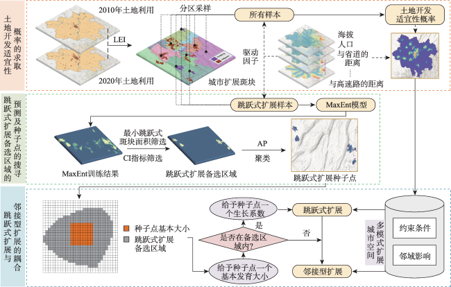
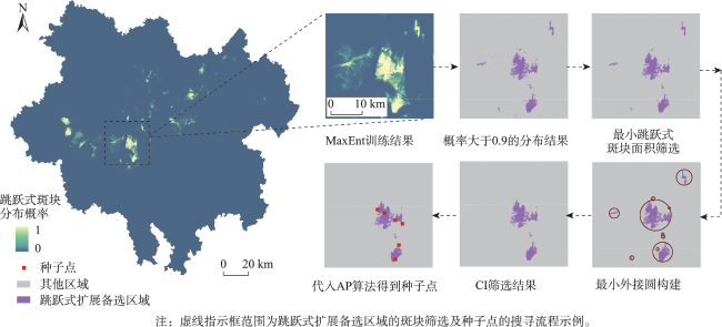
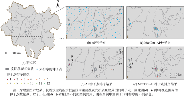
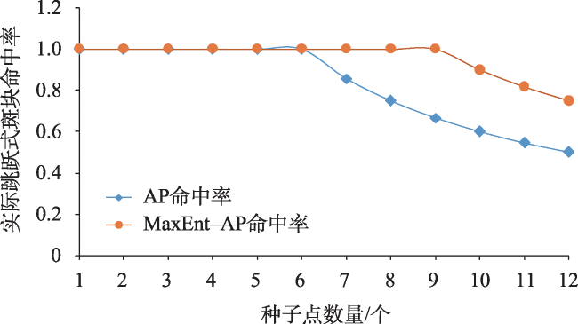
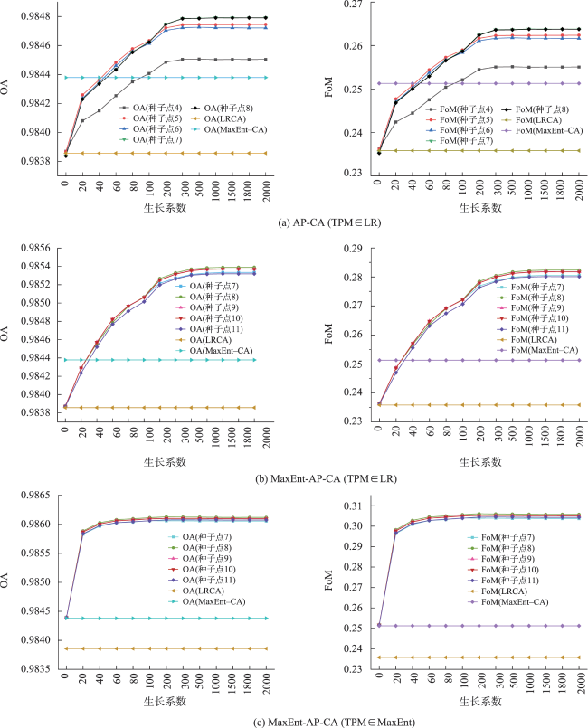
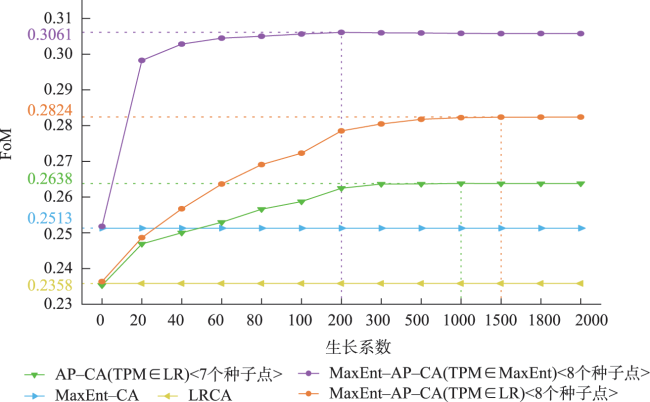
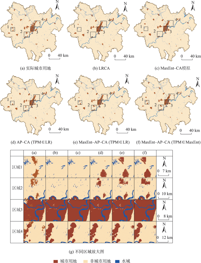
Development of multi-center clusters is an important way to optimize regional spatial structure, which results in various forms of urban space expansion, such as the adjacent type and the outlying type. Therefore, it is urgent to investigate the simulation techniques that takes into account the multi-mode expansion of urban space. However, it is still difficult to achieve the simulation of the outlying expansion in existing research, mainly due to the following problems: limited ability to show the urban growth process, large randomness of the selected "expansion seed points", and small application scale of models, etc. In this paper, a MaxEnt-AP-CA model coupling Maximum Entropy model (MaxEnt) and Affinity Propagation clustering (AP) is proposed. The MaxEnt model is used to find the alternative area of the outlying expansion, and the area and the compaction indices are used to screen the alternative area. In this way, the searching range of seed points is reduced, the randomness and the amount of data to be calculated are reduced, and the model is suitable for larger scale research. The AP algorithm is used to search for seed points in the alternative area, and these seed points grow outward from a basic size. Then the growth process of the outlying patch is demonstrated. Finally, by introducing the "growth coefficient", the conversion probabilities of different expansion modes are fused to realize the synchronous simulation of multi-mode expansion including the adjacent type and the outlying type. Taking the main metropolitan area of Chongqing as the research area, the Maxent-AP-CA is used to simulate the urban land expansion from 2010 to 2020. The results show that: (1) The accuracy of the seed points obtained by MaxEnt-AP that hit the actual outlying patch is significantly improved; (2) In terms of accuracy, the peak FoM of MaxEnt-AP-CA reaches 0.3061 with optimal parameters, which significantly improves the accuracy compared with the traditional CA model. In terms of landscape morphology, MaxEnt-AP-CA is closer to the actual situation in patch size, fragmentation degree, and aggregation degree, and can retain more patch shape features. The overall similarity between the optimal simulation results and the actual urban area is 87.04%. In terms of local details, MaxEnt-AP-CA can accurately show the outlying patches and express the real urban expansion more accurately; (3) MaxEnt-AP-CA gives consideration to multi-mode expansion, which conforms to the current situation of urban development in China and helps to promote the construction of a new urbanization pattern.

LI Qiyuan , WANG Haijun , ZHOU Zhiyong , MA Hong , CHAI Jie . Construction of Urban Spatial Multi-mode Expansion Cellular Automata Model Coupled with Maximum Entropy and Affinity Propagation Clustering[J]. Journal of Geo-information Science, 2023 , 25(7) : 1464 -1480 . DOI: 10.12082/dqxxkx.2023.220836
表1 实验数据集Tab. 1 Experimental data set |
| 数据类型 | 说明 | 年份 | 格式 | 来源 |
|---|---|---|---|---|
| 地形地貌数据 | DEM、坡度 | 2019 | 30 m×30 m栅格 | 地理空间数据云[41](http://www.gscloud.cn/) |
| 土地利用数据 | 土地利用土地覆被遥感监测数据集(CNLUCC)包括6个一级用地类型 | 2010、2020 | 30 m×30 m栅格 | 中国科学院资源环境科学数据中心[42](http://www.resdc.cn) |
| 社会经济数据 | GDP、人口 | 2010 | 1 km×1 km栅格 | |
| 道路数据 | 县道、省道、国道、高速、铁路 | 2015 | 矢量 | |
| 行政区划数据 | 区县行政区划 | 2019 | 矢量 | 全国地理信息资源目录服务系统[43](https://www.webmap.cn/main.do?method=index) |
| POI数据 | 区县级行政中心 | 2019 | 矢量 |
表2 筛选过程中斑块数量的变化Tab. 2 Changes in patch count during screening |
| 提取MaxEnt结果中概率值大于0.9的部分 | 最小跳跃式斑块面积筛选 | 值筛选 | 实际跳跃式 斑块数 | |
|---|---|---|---|---|
| 备选区域 斑块数/个 | 7032 | 43 | 19 | 10 |
表3 MaxEnt-AP-CA及对比模型的参数Tab. 3 The parameters of MaxEnt-AP-CA and the comparison models |
| 模型 | 土地开发适宜性概率求取方式 | 种子点类别 | 种子点获取范围 | 参与模拟的 种子点数量区间 |
|---|---|---|---|---|
| LRCA | Logistic Regression | — | — | — |
| MaxEnt-CA | MaxEnt | — | — | — |
| AP-CA(TPM∈LR) | Logistic Regression | AP | 研究区全局 | [4,8] |
| MaxEnt-AP-CA(TPM∈LR) | Logistic Regression | MaxEnt-AP | 跳跃式扩展备选区域 | [7,11] |
| MaxEnt-AP-CA(TPM∈MaxEnt) | MaxEnt | MaxEnt-AP | 跳跃式扩展备选区域 | [7,11] |
表4 景观指数及形态相似性结果Tab. 4 Results of landscape index and morphological similarity |
| 结果 | 景观指数 | 相似性/% | |||
|---|---|---|---|---|---|
| 实际城市用地 | 1085.8839 | 77 | 98.1551 | 2.2592 | — |
| LRCA | 529.1966 | 158 | 98.7857 | 1.3839 | 67.72 |
| MaxEnt-CA | 983.6831 | 85 | 99.0594 | 1.5088 | 82.07 |
| AP-CA(TPM∈LR) | 494.7518 | 169 | 98.4766 | 1.5219 | 70.16 |
| MaxEnt-AP-CA(TPM∈LR) | 486.1224 | 172 | 98.2183 | 1.5957 | 73.21 |
| MaxEnt-AP-CA(TPM∈MaxEnt) | 961.0697 | 87 | 98.7315 | 1.7730 | 87.04 |
表5 MaxEnt-AP-CA与部分具有代表性的多模式城市扩展CA的对比Tab. 5 Comparison between MaxEnt-AP-CA and some representative multi-mode urban expansion CA |
| [1] |
|
| [2] |
王发曾. 21世纪发展中国家城市化的深层次发展[J]. 经济地理, 2003(6):772-776.
[
|
| [3] |
|
| [4] |
中华人民共和国国家发展和改革委员会. “十四五”新型城镇化实施方案[EB/OL]. https://www.ndrc.gov.cn/fggz/fzzlgh/gjjzxgh/202207/t20220728_1332050.html?code=&state=123.
[National Development and Reform Commission of the People's Republic of China. The 14th Five-Year Plan for the Implementation of New Urbanization[EB/OL]. https://www.ndrc.gov.cn/fggz/fzzlgh/gjjzxgh/202207/t20220728_1332050.html?code=&state=123.]
|
| [5] |
陈浩, 王莉莉, 张京祥. 国家空间选择性、新城新区的开发及其房地产化——以南京河西新城为例[J]. 人文地理, 2018, 33(5):63-70.
[
|
| [6] |
王海军, 武悦, 邓羽, 等. 基于城市流和层级性的城市群扩展模型构建[J]. 地理学报, 2021, 76(12):3012-3024.
[
|
| [7] |
刘小平, 黎夏, 陈逸敏, 等. 景观扩张指数及其在城市扩展分析中的应用[J]. 地理学报, 2009, 64(12):1430-1438.
[
|
| [8] |
|
| [9] |
周成虎, 欧阳, 马廷, 等. 地理系统模拟的CA模型理论探讨[J]. 地理科学进展, 2009, 28(6):833-838.
[
|
| [10] |
|
| [11] |
|
| [12] |
|
| [13] |
|
| [14] |
|
| [15] |
张宸铭, 高尚, 何贝, 等. 基于空间句法耦合SLEUTH模型的新老城区扩展模拟研究——以开封市为例[J]. 地理研究, 2021, 40(5):1372-1386.
[
|
| [16] |
|
| [17] |
戴云哲, 杨建新, 龚健, 等. AutoPaCA:耦合过程-模式的城镇空间增长模拟模型[J]. 地球信息科学学报, 2022, 24(1):87-99.
[
|
| [18] |
|
| [19] |
何青松, 谭荣辉, 杨俊. 基于近邻传播聚类元胞自动机模型的武汉城市扩散和聚合过程同步模拟[J]. 地理学报, 2021, 76(10):2522-2535.
[
|
| [20] |
|
| [21] |
|
| [22] |
|
| [23] |
|
| [24] |
|
| [25] |
|
| [26] |
|
| [27] |
|
| [28] |
|
| [29] |
|
| [30] |
|
| [31] |
|
| [32] |
|
| [33] |
吴夏安, 徐磊青, 仲亮. 《城市居住区规划设计标准》中15分钟生活圈关键指标讨论[J]. 规划师, 2020, 36(8):33-40.
[
|
| [34] |
李琳, 黄昕珮. 基于“紧凑”内涵解读的紧凑度量与评价研究——“紧凑度”概念体系与指标体系的构建[J]. 国际城市规划, 2012, 27(1):33-43.
[
|
| [35] |
|
| [36] |
谢志文, 王海军, 张彬, 等. 城市扩展元胞自动机多结构卷积神经网络模型[J]. 测绘学报, 2020, 49(3):375-385.
[
|
| [37] |
|
| [38] |
|
| [39] |
李嘉译, 匡鸿海, 王佩佩. 重庆市主城区城市扩张对生态系统服务影响的时空评估[J]. 长江流域资源与环境, 2020, 29(4):859-868.
[
|
| [40] |
|
| [41] |
中国科学院地理科学与资源研究所. 资源环境科学与数据中心[DB/OL]. https://www.resdc.cn/.
[Institute of Ge- ographic Sciences and Resources, Chinese Academy of Sciences. Resource and Environment Science and Data Center[DB/OL]. https://www.resdc.cn/.]
|
| [42] |
中华人民共和国自然资源部. 全国地理信息资源目录服务系统[DB/OL]. https://www.webmap.cn/main.do?method=index.
[Ministry of Natural Resources of the People's Republic of China. National Catalogue Service For Geographic Information[DB/OL]. https://www.webmap.cn/main.do?method=index.]
|
| [43] |
中国科学院计算机网络信息中心. 地理空间数据云[DB/OL]. http://www.gscloud.cn/.
[Computer Network Information Center of Chinese Academy of Sciences. Geospatial Data Cloud[DB/OL]. http://www.gscloud.cn/.]
|
/
| 〈 |
|
〉 |