
Journal of Geo-information Science >
Construction of Sparse Non-Photosynthetic Vegetation Index Combining Sentinel-2 Data and Spectral Features
Received date: 2022-12-01
Revised date: 2023-03-26
Online published: 2023-09-05
Supported by
National Key R&D Program of China(2020YFC1511602)
National Natural Science Foundation of China(32060373)
National Natural Science Foundation of China(41801394)
Natural Science Foundation of Gansu Province(20JR10RA465)
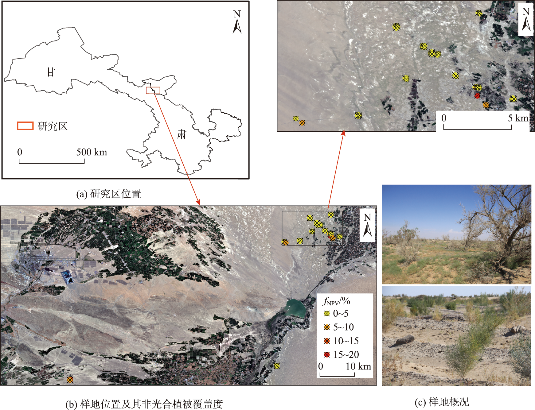
Non-photosynthetic Vegetation (NPV) is a key component in the ecosystem of arid and semi-arid regions and plays a vital role in the carbon cycle of vegetations. Obtaining the quantitative information of NPV is of great significance for scientific assessment of land desertification and scientific prevention and control of desertification. This study takes Minqin County, Gansu Province as the research area, analyzes the NPV and other end-component spectral information collected by the hyperspectral instrument in the research area, and constructs the vegetation index for extracting sparse NPV coverage based on Sentinel-2 MSI image. The measured NPV coverage is used as the verification data, and the coefficient of determination (R2), root mean square error, and significant p-value are used for model accuracy evaluation. The results show that: ① Based on the spectral analysis using the original spectral method, the first derivative transformation method, the reciprocal logarithm method, and the continuous elimination method, it is found that the envelope value of the NPV spectrum obtained by the continuous elimination method is significantly different from that of Photosynthetic Vegetation (PV) and Bare Soil (BS); ② After calculating the envelope difference of the green light band and the spectral reflectance ratio of the short wave infrared band, the difference between the NPV and PV and BS spectral eigenvalues can be effectively detected, in order to extract the NPV information and obtain a new index representing the NPV coverage information; ③ Through precision verification, it is found that the newly constructed NPV index-Envelope Difference Vegetation Index (EDVI) has the best correlation with the measured NPV coverage on the ground (R2=0.71, RMSE=0.0170, p<0.01), followed by the four-band red edge soil adjusted NDTI (S_NDTI4RE) (R2 is 0.57 with weight γ=0). While other NPVIs models have poor accuracy in estimating sparse NPV coverage. Our results indicate that the EDVI index model constructed in this paper can effectively achieve the rapid extraction and monitoring of NPV at large scale in arid and semi-arid regions through spectral feature analysis.

YUAN Hao , JI Cuicui , YANG Xuemei , CHEN Maolin , PAN Jianping , CAO Yiming . Construction of Sparse Non-Photosynthetic Vegetation Index Combining Sentinel-2 Data and Spectral Features[J]. Journal of Geo-information Science, 2023 , 25(9) : 1894 -1907 . DOI: 10.12082/dqxxkx.2023.220938
表1 Sentinel-2 MSI波段参数Table 1 Sentinel-2 MSI Band Parameters Table |
| 波段编号 | 波段名 | 波长范围/nm | 空间分辨率/m |
|---|---|---|---|
| B1 | AEROSOLS | 442.3~443.9 | 60 |
| B2 | BLUE | 492.1~496.6 | 10 |
| B3 | GREEN | 559.0~560.0 | 10 |
| B4 | RED | 664.5~665.0 | 10 |
| B5 | RE1 | 703.8~703.9 | 20 |
| B6 | RE2 | 739.1~740.2 | 20 |
| B7 | RE3 | 779.7~782.5 | 20 |
| B8 | NIR | 833.0~835.1 | 10 |
| B8A | RE4 | 864.0~864.8 | 20 |
| B9 | WATER VAPOR | 943.2~945.0 | 60 |
| B11 | SWIR1 | 1 610.4~1 613.7 | 20 |
| B12 | SWIR2 | 2 185.7~2 202.4 | 20 |
表2 常用多光谱NPVIsTab. 2 Commonly used multispectral NPVIs |
| NPVIs | 公式 | 公式编号 | 参考文献 |
|---|---|---|---|
| NDI5 | NDI5=(b8-b11)/(b8+b11) | (10) | [14] |
| NDI7 | NDI7=(b8-b12)/(b8+b12) | (11) | [14] |
| NDTI | NDTI=(b11-b12)/(b11+b12) | (12) | [15] |
| NDSVI | NDSVI=(b11-b4)/(b11+b4) | (13) | [16] |
| STI | STI=b11/b12 | (14) | [15] |
| DFI | DFI=100×(1-b12/b11)×b4/b8A | (15) | [18] |
| SWIR32 | SWIR32=b12/b11 | (16) | [17] |
| S_NDTI4RE (γ=0) | S_NDTI4RE (γ=0)=(b8-b7)×2/(b8+b7+1) | (17) | [19] |
注:式中b4、b8、b8A、b11、b12分别为Sentinel-2 MSI影像数据RED、NIR、RE4、SWIR1以及SWIR2波段的光谱反射率。 |
表3 NPVIs回归模型精度Tab. 3 NPVIs regression model precision |
| NPVIs | RMSE | R2 | |
|---|---|---|---|
| EDVI | 0.017 0 | 0.71 | <0.01 |
| S_NDTI4RE ( ) | 0.018 5 | 0.57 | <0.01 |
| DFI | 0.017 4 | 0.30 | <0.01 |
| SWIR32 | 0.017 4 | 0.30 | <0.01 |
| NDTI | 0.017 3 | 0.29 | <0.01 |
| STI | 0.016 9 | 0.27 | <0.01 |
| NDI7 | 0.014 5 | 0.17 | <0.01 |
| NDI5 | 0.011 0 | 0.07 | <0.05 |
| NDSVI | 0.008 2 | 0.03 | <0.05 |
| [1] |
李晓松. 干旱地区稀疏植被覆盖度高光谱遥感定量反演研究[D]. 北京: 中国林业科学研究院, 2008.
[
|
| [2] |
|
| [3] |
姬翠翠, 骆义峡, 李晓松, 等. Sentinel-1和Sentinel-2协同反演稀疏非光合植被覆盖度方法研究[J]. 遥感学报, 2021.
[
|
| [4] |
|
| [5] |
|
| [6] |
|
| [7] |
章文波, 符素华, 刘宝元. 目估法测量植被覆盖度的精度分析[J]. 北京师范大学学报(自然科学版),2001, 3(2001):402-408.
[
|
| [8] |
柴国奇, 王静璞, 王光镇. 基于MODIS数据的典型草原非光合植被覆盖度估算[J]. 国土资源遥感, 2019, 31(3):234-241.
[
|
| [9] |
|
| [10] |
姬翠翠. 干旱区稀疏光合与非光合植被多尺度光谱混合解析方法研究[D]. 武汉: 武汉大学. 2018.
[
|
| [11] |
|
| [12] |
骆义峡, 姬翠翠, 李晓松. 植被指数模型估算干旱区稀疏光合/非光合植被覆盖度[J]. 遥感信息, 2022, 37(03):57-64.
[
|
| [13] |
|
| [14] |
|
| [15] |
|
| [16] |
|
| [17] |
|
| [18] |
|
| [19] |
|
| [20] |
|
| [21] |
|
| [22] |
王堃. 贵州威宁草海湿地优势植被群丛的光谱特征分析及其识别[D]. 贵州: 贵州师范大学, 2020.
[
|
| [23] |
孙岩. 湿地植物高光谱特征分析与物种识别模型构建[D]. 北京: 清华大学, 2008.
[
|
| [24] |
|
| [25] |
潘晓玲. 干旱区绿洲生态系统动态稳定性的初步研究[J]. 第四纪研究, 2001, 21(4):345-351.
[
|
| [26] |
张云霞, 李晓兵, 陈云浩. 草地植被盖度的多尺度遥感与实地测量方法综述[J]. 地球科学进展, 2003, 18(1):85-93.
[
|
| [27] |
|
| [28] |
|
| [29] |
|
| [30] |
王光镇, 王静璞, 韩柳, 等. 基于实测光谱模拟Landsat-8 OLI数据估算非光合植被覆盖度[J]. 地球信息科学学报, 2018, 20(11):1667-1678.
[
|
| [31] |
|
| [32] |
|
| [33] |
|
/
| 〈 |
|
〉 |