
Journal of Geo-information Science >
Simulation of Vegetation Gross Primary Productivity and Its Application in Fujian Province of China Using Remote Sensing and CatBoost Algorithm
Received date: 2022-08-24
Revised date: 2022-11-03
Online published: 2023-09-05
Supported by
Science and Technology Plan Leading Project of Fujian Province, China(2021Y0005)
Water Conservancy Science and Technology Project of Fujian Province, China(MSK202301)
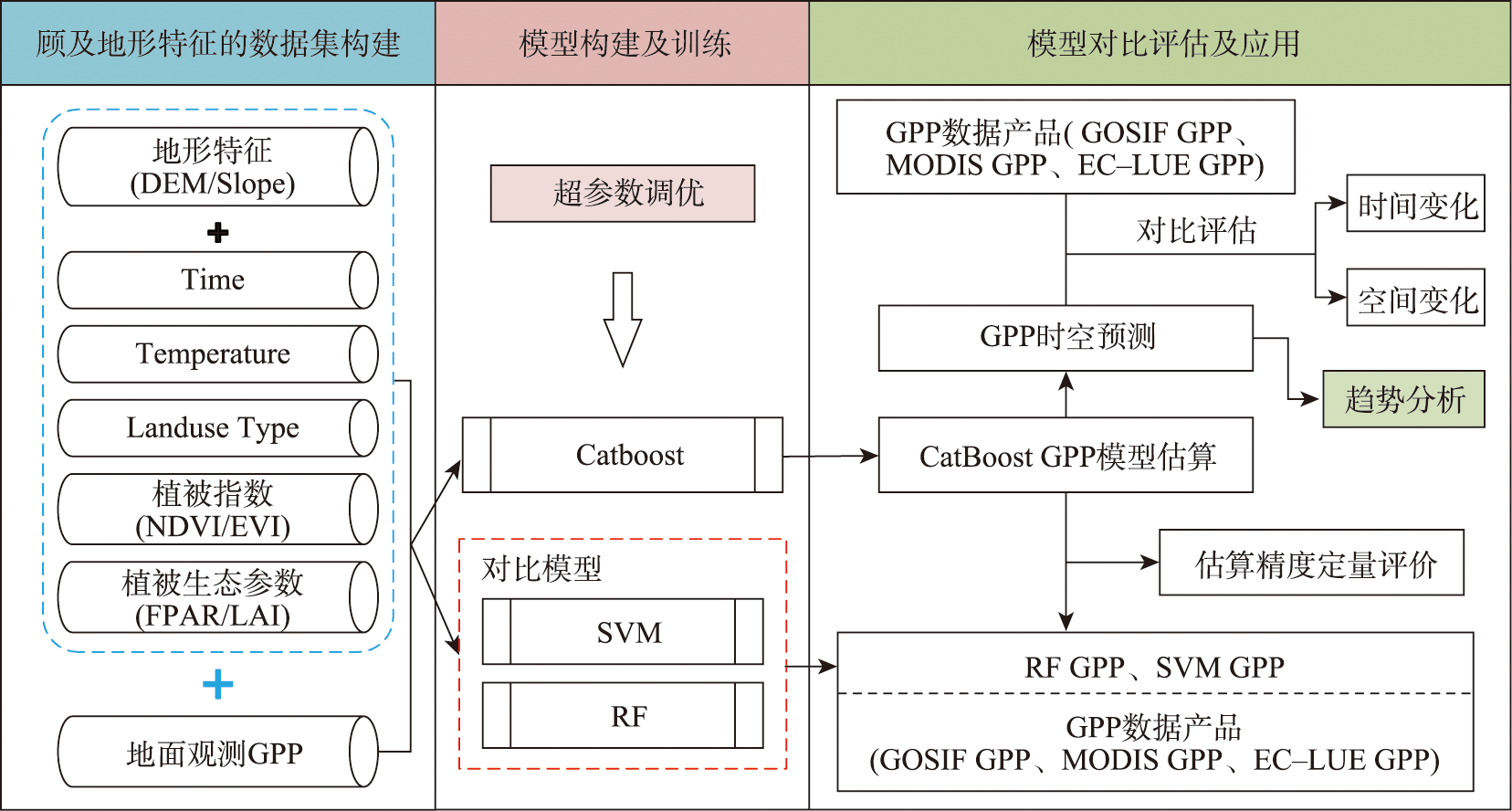
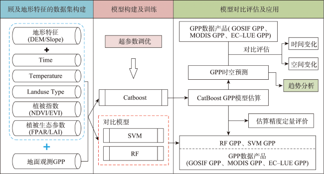
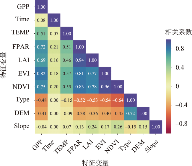
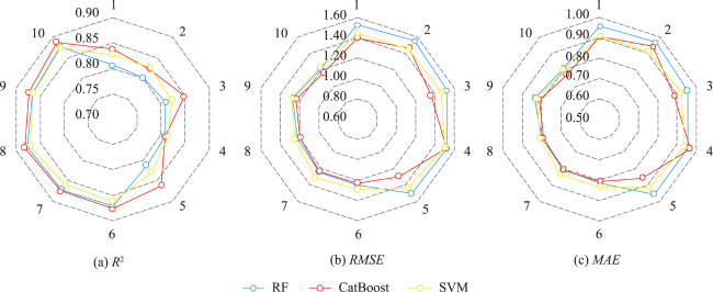
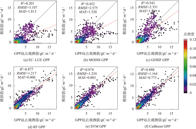
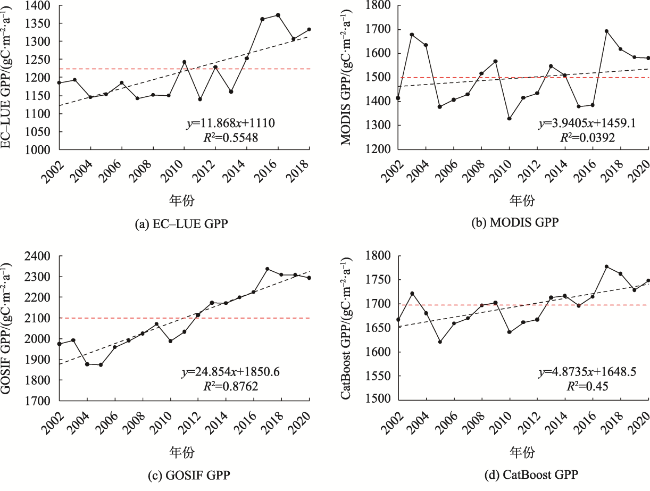
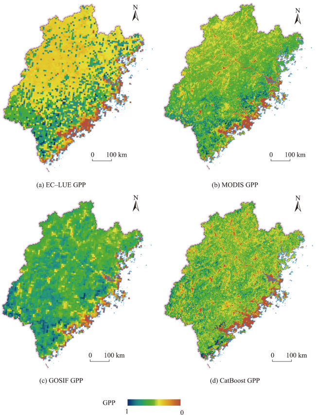
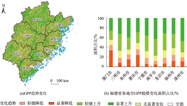
As an important indicator to measure the health of terrestrial ecosystems, the Gross Primary Productivity (GPP) of vegetation can directly reflect the improvement of regional environment. Therefore, accurate estimation of vegetation GPP changes is of great significance to regional sustainable development. In this paper, a GPP estimation model using the CatBoost algorithm integrating topographic data was developed. Using the vorticity flux observation data from China and Japan, this model was applied to simulate the long term GPP of Fujian Province where the topographic effect is significant. The results show that: (1) Terrain features are important parameters for the estimation of GPP using machine learning methods. The accuracy of GPP simulation results with terrain features included is significantly improved, and the Root Mean Square Error (RMSE) is decreased by 16%; (2) The GPP estimation model based on CatBoost has higher accuracy and stronger robustness and effectively reduces the overestimation and underestimation phenomena existing in traditional GPP estimation models and commonly used machine learning models (e.g., random forest and support vector machine). The coefficient of determination (R²) is 0.888, the RMSE is 1.164 gC·m-2·day-1, and the Mean Absolute Error (MAE) is 0.773 gC·m-2·day-1; (3) The multi-year GPP changes in Fujian Province simulated by the CatBoost GPP estimation model are highly consistent with the GOSIF GPP estimation results, indicating a more accurate GPP spatial distribution in Fujian Province. It is found that the mean GPP of Fujian Province from 2002 to 2020 was 1 697 gC·m-2·a-1. The overall spatial distribution is characterized by "decreasing from southeast to northwest", and the multi-year GPP variation shows a trend of "non-significant fluctuation increase". This study provides a new method and useful data for regional GPP estimation and ecological environment management.
LI Yujie , JIANG Hong , LIU Xuanguang . Simulation of Vegetation Gross Primary Productivity and Its Application in Fujian Province of China Using Remote Sensing and CatBoost Algorithm[J]. Journal of Geo-information Science, 2023 , 25(9) : 1908 -1922 . DOI: 10.12082/dqxxkx.2023.220623
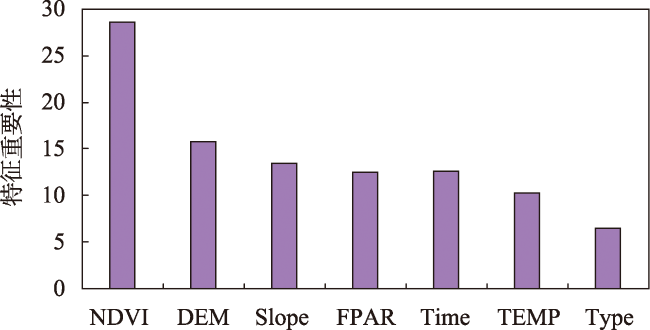
表1 模型输入参数组合方案Tab. 1 Model input parameter combination scheme |
| 组合 | Time | TEMP | 植被生态参数 | 植被指数 | 植被类型 | 地形特征 | ||||
|---|---|---|---|---|---|---|---|---|---|---|
| LAI | FPAR | EVI | NDVI | DEM | Slope | |||||
| 未加入地形特征 | 1 | √ | √ | √ | √ | √ | √ | √ | ||
| 2 | √ | √ | √ | √ | √ | |||||
| 3 | √ | √ | √ | √ | √ | |||||
| 4 | √ | √ | √ | √ | √ | |||||
| 5 | √ | √ | √ | √ | √ | |||||
| 加入地形特征 | 6 | √ | √ | √ | √ | √ | √ | √ | √ | √ |
| 7 | √ | √ | √ | √ | √ | √ | √ | |||
| 8 | √ | √ | √ | √ | √ | √ | √ | |||
| 9 | √ | √ | √ | √ | √ | √ | √ | |||
| 10 | √ | √ | √ | √ | √ | √ | √ | |||
注:√为输入特征中包括该因子。 |
表2 GPP观测站点信息Tab. 2 GPP observation sites information |
| 站点 | 纬度/°N | 经度/°E | 植被类型 | 生态系统类型 | 数据时间范围 | 国家 |
|---|---|---|---|---|---|---|
| 千烟洲(CN-Qia) | 26.74 | 115.06 | 常绿针叶林 | 森林生态系统 | 2003—2010年 | 中国 |
| 鼎湖山(CN-Din) | 23.17 | 112.53 | 常绿阔叶林 | 森林生态系统 | 2003—2010年 | 中国 |
| 西双版纳(CN-XSBN) | 21.93 | 101.27 | 常绿阔叶林 | 森林生态系统 | 2003—2010年 | 中国 |
| 莫什里桦树林遗址(JP-MBF) | 44.39 | 142.32 | 落叶阔叶林 | 森林生态系统 | 2003—2005年 | 日本 |
| 长白山(CN-Cha) | 42.40 | 128.10 | 混交林 | 森林生态系统 | 2003—2010年 | 中国 |
| 濑户混交林遗址(JP-SMF) | 35.26 | 137.08 | 混交林 | 森林生态系统 | 2002—2006年 | 日本 |
| 海北高寒灌丛(CN-HBSH) | 37.67 | 101.33 | 草地 | 草地生态系统 | 2003—2010年 | 中国 |
| 长岭草甸草原(CN-Cng) | 44.59 | 123.51 | 草地 | 草地生态系统 | 2007—2010年 | 中国 |
| 海北高寒草甸(CN-HaM) | 37.37 | 101.18 | 草地 | 草地生态系统 | 2002—2004年 | 中国 |
| 多伦退化草地(CN-Du3) | 42.06 | 116.28 | 草地 | 草地生态系统 | 2009—2010年 | 中国 |
| 当雄高寒草甸(CN-Dan) | 30.50 | 91.07 | 草地 | 草地生态系统 | 2004—2010年 | 中国 |
| 内蒙古典型草原(CN-NMG) | 43.33 | 116.40 | 草地 | 草地生态系统 | 2004—2010年 | 中国 |
| 海北湿地(CN-HBSW) | 37.61 | 101.33 | 草地 | 草地生态系统 | 2004—2009年 | 中国 |
| 禹城(CN-YC) | 36.83 | 116.57 | 农田 | 农田生态系统 | 2003—2010年 | 中国 |
表3 数据概况Tab. 3 Data description |
| 数据名称 | 空间分辨率/m | 时间分辨率 |
|---|---|---|
| MOD11A2 | 1 000 | 8 d |
| MOD13A3 | 1 000 | 1 m |
| MOD15A2H | 500 | 8 d |
| MCD12Q1 | 500 | 1 y |
表4 土地利用类型重分类Tab. 4 The reclassification of land use type |
| 编号 | 土地利用类型重分类 | 原始土地利用类型及编号 |
|---|---|---|
| 1 | 森林 | 1常绿针叶林 |
| 2常绿阔叶林 | ||
| 3落叶针叶林 | ||
| 4落叶阔叶林 | ||
| 5混交林 | ||
| 6郁闭灌丛 | ||
| 7稀疏灌丛 | ||
| 2 | 草地 | 8稀树草原 |
| 9热带稀树草原 | ||
| 10草原 | ||
| 3 | 农田 | 12农田 |
| 14农田/自然植被 |
表5 GPP数据产品来源及概况Tab. 5 GPP data products sources and overview |
| 数据名称 | 空间分辨率 | 时间分辨率/d | 时间范围 | 数据来源 |
|---|---|---|---|---|
| MOD17A2H GPP | 500 m | 8 | 2002—2020年 | https://ladsweb.modaps.eosdis.nasa.gov |
| GOSIF GPP | 0.05° | 8 | 2002—2020年 | https://globalecology.unh.edu |
| EC-LUE GPP | 0.05° | 8 | 2002—2018年 | https://doi.org/10.6084/m9.figshare.8942336.v3 |
| [1] |
邓安健, 郭海波, 胡洁, 等. GOSAT卫星数据监测中国大陆上空CO2浓度时空变化特征[J]. 遥感学报, 2020, 24(3):319-325.
[
|
| [2] |
|
| [3] |
侯英雨, 柳钦火, 延昊, 等. 我国陆地植被净初级生产力变化规律及其对气候的响应[J]. 应用生态学报, 2007, 18(7):1546-1553.
[
|
| [4] |
窦贤明. 机器学习方法在陆地生态系统碳水通量模拟中的应用研究[D]. 徐州: 中国矿业大学, 2018.
[
|
| [5] |
|
| [6] |
|
| [7] |
|
| [8] |
张坤, 刘乃文, 高帅, 等. 数据驱动的植被总初级生产力估算方法研究[J]. 遥感技术与应用, 2020, 35(4):943-949.
[
|
| [9] |
|
| [10] |
|
| [11] |
|
| [12] |
齐建东, 黄金泽, 贾昕. 基于XGBoost-ANN的城市绿地净碳交换模拟与特征响应[J]. 农业机械学报, 2019, 50(5):269-278.
[
|
| [13] |
|
| [14] |
|
| [15] |
|
| [16] |
|
| [17] |
|
| [18] |
|
| [19] |
陈点点, 陈芸芝, 冯险峰, 等. 基于超参数优化CatBoost算法的河流悬浮物浓度遥感反演[J]. 地球信息科学学报, 2022, 24(4):780-791.
[
|
| [20] |
|
| [21] |
|
| [22] |
|
| [23] |
|
| [24] |
常学礼, 吕世海, 冯朝阳, 等. 地形对草甸草原植被生产力分布格局的影响[J]. 生态学报, 2015, 35(10):3339-3348.
[
|
| [25] |
江洪, 虞嘉玮, 蒋世豪, 等. 基于CASA模型和SEVI指数的福建省植被NPP遥感估算与分析[J]. 海南大学学报(自然科学版), 2021, 39(4):372-382.
[
|
| [26] |
刘玉安, 黄波, 易成功, 等. 基于地形校正的植被净初级生产力遥感模拟及分析[J]. 农业工程学报, 2013, 29(13):130-141.
[
|
| [27] |
|
| [28] |
吴炳方, 曾源, 黄进良. 遥感提取植物生理参数LAI/FPAR的研究进展与应用[J]. 地球科学进展, 2004, 19(4):585-590.
[
|
| [29] |
王宇琦, 沈润平, 黄安奇, 等. 2001—2017年中国不同耕作区重建MODIS LAI时空动态[J]. 地球信息科学学报, 2021, 23(4):658-669.
[
|
| [30] |
葛静. 中国北方地区草地地上生物量遥感估测及变化分析研究[D]. 兰州: 兰州大学, 2022.
[
|
| [31] |
李莉, 陈浩哲, 赵奇慧, 等. 基于CS-CatBoost的温室番茄水分胁迫预测模型[J]. 农业机械学报, 2021, 52(S1):427-433.
[
|
| [32] |
卢雪梅, 苏华. 基于OLCI数据的福建近海悬浮物浓度遥感反演[J]. 环境科学学报, 2020, 40(8):2819-2827.
[
|
| [33] |
朱晓波. 基于深度学习的中国北方草地生态系统呼吸估算研究[D]. 重庆: 西南大学, 2020.
[
|
| [34] |
| [35] |
芦华, 谢旻, 吴钲, 等. 基于机器学习的成渝地区空气质量数值预报PM2.5订正方法研究[J]. 环境科学学报, 2020, 40(12):4419-4431.
[
|
| [36] |
|
| [37] |
Li, Xiao. Mapping photosynthesis solely from solar-induced chlorophyll fluorescence: A global, fine-resolution dataset of gross primary production derived from OCO-2[J]. Remote Sensing, 2019, 11(21):2563. DOI:10.3390/rs11212563
|
| [38] |
|
| [39] |
|
| [40] |
王文辉, 马祥庆, 邹显花, 等. 2000—2010年福建省植被覆盖度的时空演变特征[J]. 水土保持研究, 2017, 24(4):234-239,246.
[
|
| [41] |
|
| [42] |
|
| [43] |
崔林丽, 杜华强, 史军, 等. 中国东南部植被NPP的时空格局变化及其与气候的关系研究[J]. 地理科学, 2016, 36(5):787-793.
[
|
| [44] |
崔林丽, 史军, 肖风劲. 气候要素及El Ni?o/La Ni?a事件对中国陆地NPP变化的影响[J]. 地理学报, 2018, 73(1):54-66.
[
|
| [45] |
骆泓鉴, 明冬萍, 徐录. 基于GEE的遥感生态指数时序计算[J]. 自然资源遥感, 2022, 34(2):271-277.
[
|
| [46] |
白雪洁, 王旭峰, 柳晓惠, 等. 黑河流域湿地、农田、草地生态系统碳通量变化特征及驱动因子分析[J]. 遥感技术与应用, 2022, 37(1):94-107.
[
|
| [47] |
周晓雪, 李楠, 潘耀忠, 等. 人工蜂群算法优化SVR的叶面积指数反演[J]. 遥感学报, 2022, 26(4):766-780.
[
|
| [48] |
丛楠, 张扬建, 朱军涛. 北半球中高纬度地区近30年植被春季物候温度敏感性[J]. 植物生态学报, 2022, 46(2):125-135.
[
|
| [49] |
张心竹, 王鹤松, 延昊, 等. 2001—2018年中国总初级生产力时空变化的遥感研究[J]. 生态学报, 2021, 41(16):6351-6362.
[
|
| [50] |
|
| [51] |
张方敏, 居为民, 陈镜明, 等. 基于遥感和过程模型的亚洲东部陆地生态系统初级生产力分布特征[J]. 应用生态学报, 2012, 23(2):307-318.
[
|
| [52] |
|
| [53] |
高振翔, 叶剑, 丁仁惠, 等. 中国植被总初级生产力对气候变化的响应[J]. 水土保持研究, 2022, 29(4):394-399,414.
[
|
| [54] |
|
| [55] |
|
/
| 〈 |
|
〉 |