
Journal of Geo-information Science >
Spatial Form of Metro Catchment Areas and Its Influencing Factors in Xiamen City
Received date: 2023-05-08
Revised date: 2023-07-08
Online published: 2023-09-22
Supported by
National Natural Science Foundation of China(52078224)
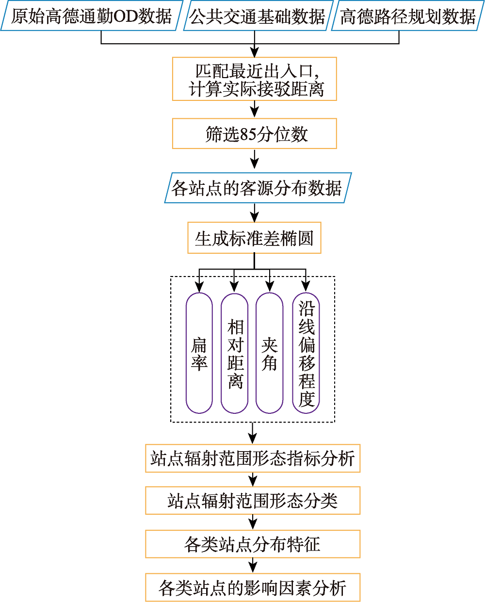
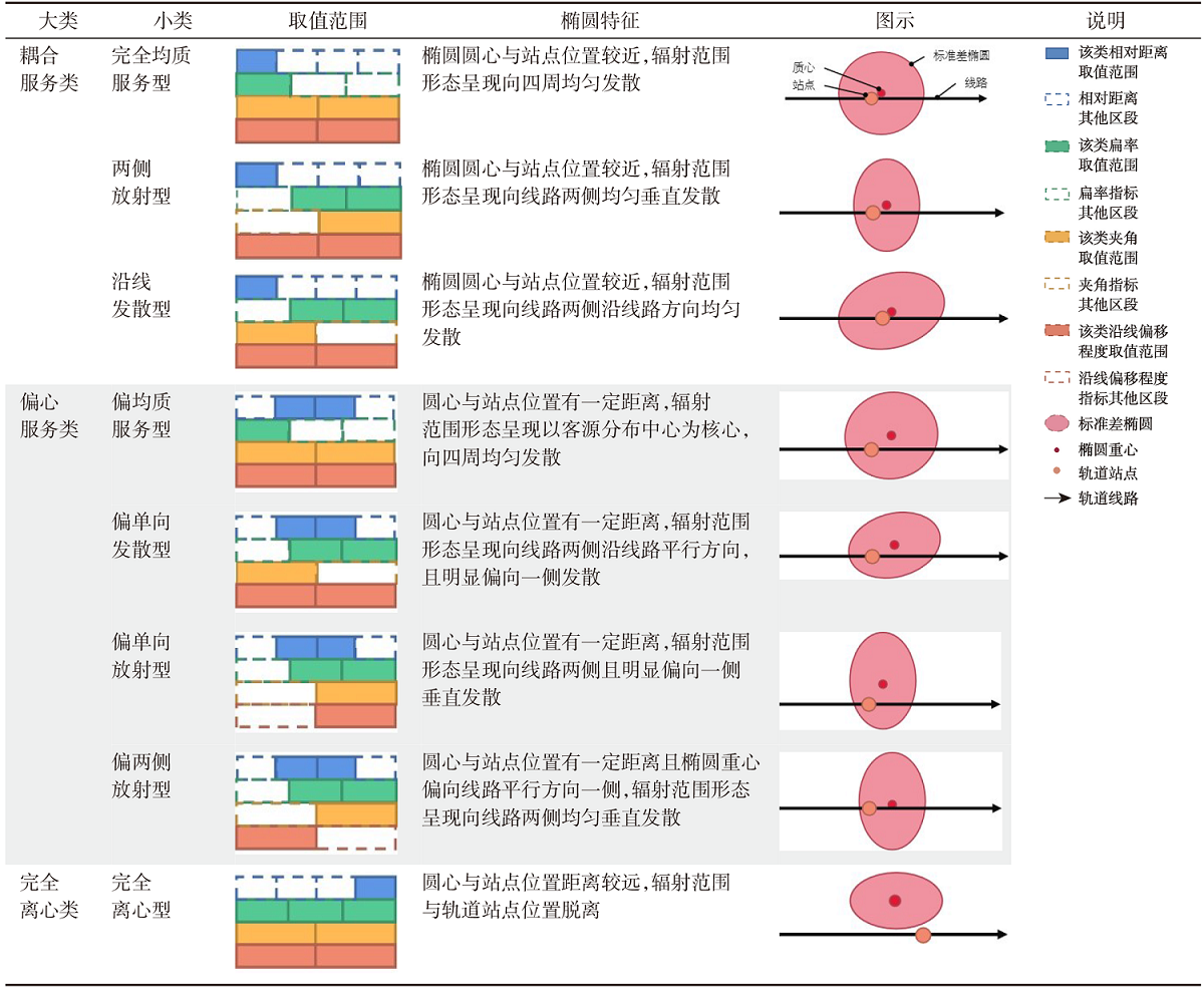
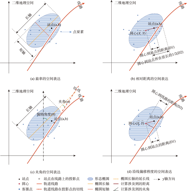
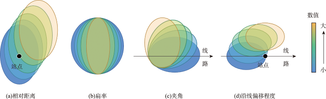
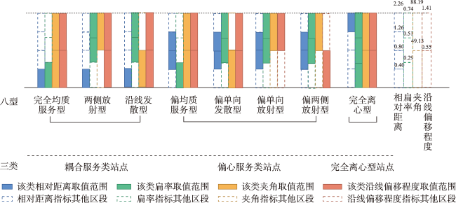
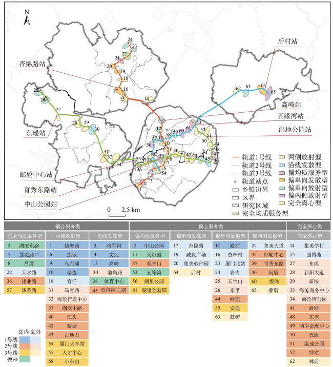
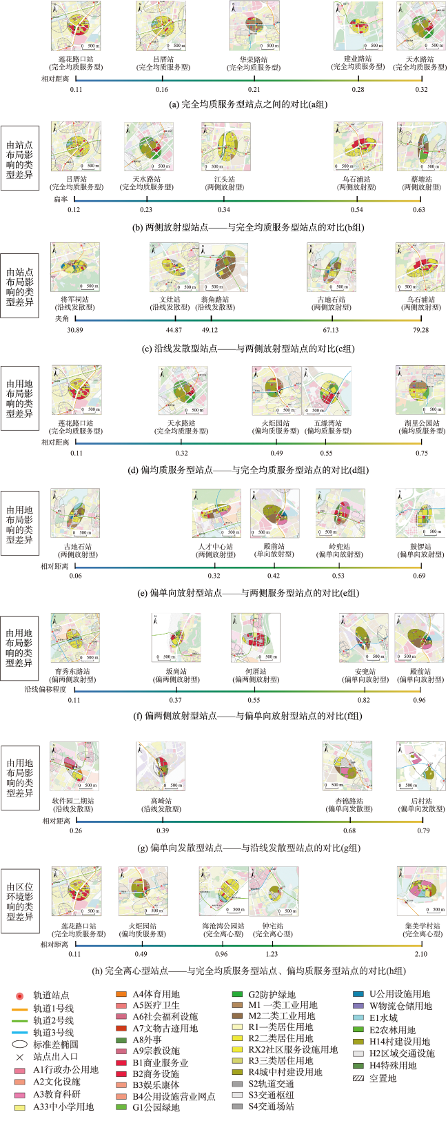
It is of great significance to study the spatial form of the catchment area of metro stations and their influencing factors for establishing a long-term interaction mechanism between rail transit and the built environment and guiding the development of land use around metro stations based on the TOD development model. In order to more accurately express the form characteristics of the catchment area of the stations, this paper takes Xiamen as an example, obtains the spatial distribution of the actual passenger flow source of each station of the metro through the Amap commuting OD data and the Amap route planning data, and uses the Standard Deviation Ellipse (SDE) method to establish the oblateness, relative distance, angle, and offset along the line to describe the form of the catchment area of each station. Based on the index system, the spatial form types of the catchment area of metro stations are summarized, and the influence mechanism of each station and the surrounding built environment, and station attributes under various form categories are revealed. The results show that: ① There are obvious differences in the eccentricity and aggregation direction of the catchment area of the metro stations inside and outside the island in Xiamen. The catchment area direction of most stations tends to be vertical to the line, and the source center tends to shift to the vertical direction of the line; ② According to the importance of the four indicators to measure the homogenization of the service scope of the station, the stations are divided into three categories: coupling service, eccentric service, and complete centrifugal service, and further divided into eight spatial forms. Among them, the coupling service stations are closest to the homogenization mode of theoretical TOD; ③ There is a certain aggregation phenomenon in the spatial distribution of various stations. The coupling service stations are mainly distributed in the west and south of the island. The eccentric service stations are mainly distributed in the north of the island and outside the island. The completely centrifugal stations are mainly distributed outside the island and in the east of the island; ④ The scale and location of factors such as land use layout and development degree, station density and layout, and location environment will make the station form different catchment area forms. The results are of great significance for supplementing the research methods of the catchment area of metro stations and improving the comprehensive benefits of rail transit.
YAN Congxiao , GAO Yueer , WANG Qiang , CHEN Ye . Spatial Form of Metro Catchment Areas and Its Influencing Factors in Xiamen City[J]. Journal of Geo-information Science, 2023 , 25(10) : 2055 -2069 . DOI: 10.12082/dqxxkx.2023.230253
表1 厦门轨道站点辐射范围形态椭圆分类及特征Tab. 1 The classification and characteristics of the catchment area form ellipse of Xiamen metro stations |
 |
| [1] |
|
| [2] |
|
| [3] |
|
| [4] |
王淑伟, 孙立山, 荣建. 北京市轨道站点吸引范围研究[J]. 交通运输系统工程与信息, 2013, 13(3):183-188.
[
|
| [5] |
申犁帆, 王烨, 张纯, 等. 轨道站点合理步行可达范围建成环境与轨道通勤的关系研究——以北京市44个轨道站点为例[J]. 地理学报, 2018, 73(12):2423-2439.
[
|
| [6] |
|
| [7] |
曹哲静. 城市商业中心与交通中心的叠合与分异:基于复杂网络分析的东京轨道交通网络与城市形态耦合研究[J]. 国际城市规划, 2020, 35(3):42-53.
[
|
| [8] |
凌晓红, 王颖. 轨道交通站点地区空间网络形态研究——基于广州3个地铁站域的比较分析[J]. 都市快轨交通, 2022, 35(4):87-94.
[
|
| [9] |
|
| [10] |
殷子渊, 薛求理. 深港轨道站站域空间紧凑度对比研究[J]. 城市规划, 2016, 40(3):76-82.
[
|
| [11] |
王书灵, 张哲宁, 付浩洋, 等. 城市轨道交通站点周边土地利用的空间梯度特性研究[J]. 都市快轨交通, 2022, 35(3):36-41.
[
|
| [12] |
|
| [13] |
曾如思, 沈中伟, 罗克乾. 轨道交通站域商业集聚特征与演变研究——基于POI数据的实证分析[J]. 南方建筑, 2020(6):126-132.
[
|
| [14] |
于洋, 周睿, 吴冰瑕, 等. TOD导向下地铁站域商业空间演变与优化路径 ——以成都市3个城市级地铁站域为例[J]. 规划师, 2022, 38(4):107-114.
[
|
| [15] |
唐健雄, 朱媛媛, 刘雨婧, 等. 典型旅游城市空间形态演变及影响因素——以张家界为例[J]. 经济地理, 2022, 42(1):221-229.
[
|
| [16] |
李留通, 张森森, 赵新正, 等. 文化产业成长对城市空间形态演变的影响——以西安市核心区为例[J]. 地理研究, 2021, 40(2):431-445.
[
|
| [17] |
陈德权, 兰泽英. 基于POI数据的城市中心体系识别与边界提取——以长沙市中心六区为例[J]. 现代城市研究, 2020, 35(4):82-89.
[
|
| [18] |
|
| [19] |
|
| [20] |
赵璐, 赵作权. 基于特征椭圆的中国经济空间分异研究[J]. 地理科学, 2014, 34(8):979-986.
[
|
| [21] |
申庆喜, 李诚固, 刘倩. 基于服务设施布局视角的城市空间结构研究——以长春主城区为例[J]. 经济地理, 2017, 37(3):129-135.
[
|
| [22] |
郭亮, 郑朝阳, 黄建中, 等. 基于通勤圈识别的大城市空间结构优化——以武汉市中心城区为例[J]. 城市规划, 2019, 43(10):43-54.
[
|
| [23] |
|
| [24] |
|
| [25] |
|
| [26] |
王晓军, 张文强, 刘思远. 地铁站内外一体化导航系统关键技术研究及实现[J]. 都市快轨交通, 2022, 35(3):48-53.
[
|
| [27] |
|
| [28] |
蒋源, 陈小鸿, 胥川, 等. 轨道站点骑行接驳吸引范围及其影响要素研究[J]. 武汉理工大学学报(交通科学与工程版), 2021, 45(2):225-230.
[
|
| [29] |
|
| [30] |
|
| [31] |
郭瑞利, 黄正东. 基于成本加权距离分析的轨道站点多级影响区划分研究[J]. 现代城市研究, 2021, 36(8):73-82.
[
|
| [32] |
陈阳, 李伟芳, 任丽燕, 等. 空间统计视角下的农村居民点分布变化及驱动因素分析——以鄞州区滨海平原为例[J]. 资源科学, 2014, 36(11):2273-2281.
[
|
| [33] |
|
| [34] |
|
/
| 〈 |
|
〉 |
