
Journal of Geo-information Science >
Modelling and Storage Method for Hexagonal Remote Sensing Images in Rhombic Triacontahedron Discrete Global Grid System
Received date: 2023-07-21
Revised date: 2023-11-15
Online published: 2023-12-05
Supported by
Foundation item: Special Science Fund for Innovation Ecosystem Construction of National Supercomputing Center in Zhengzhou(201400210100)
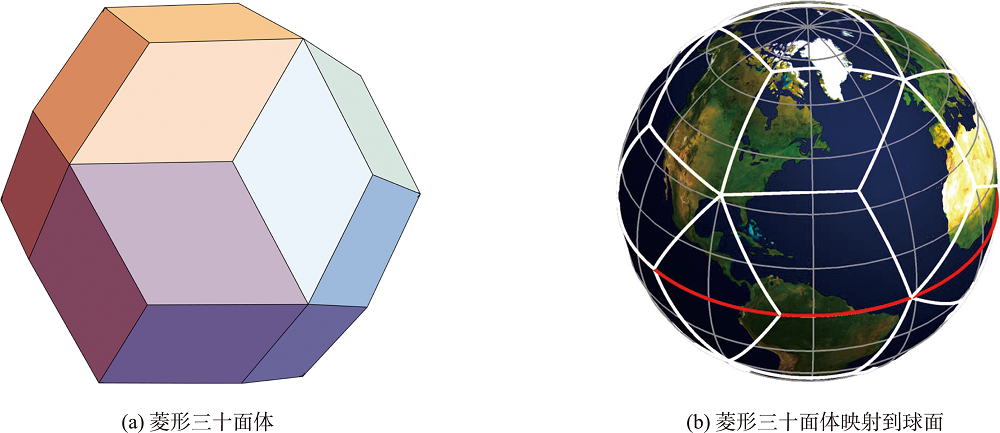
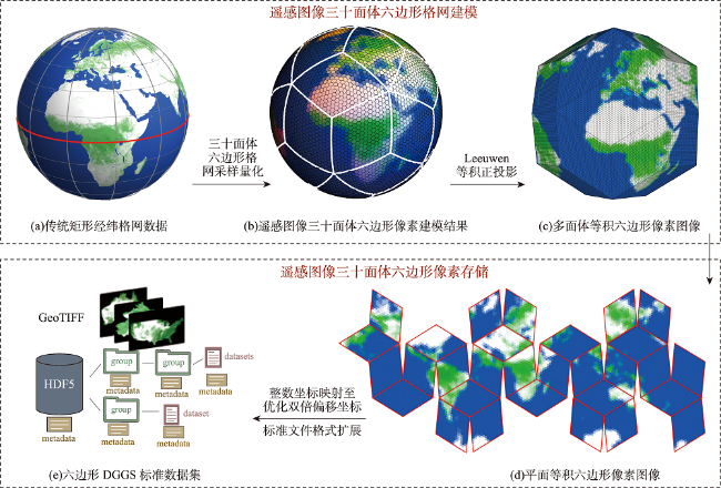
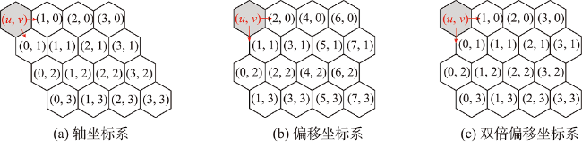
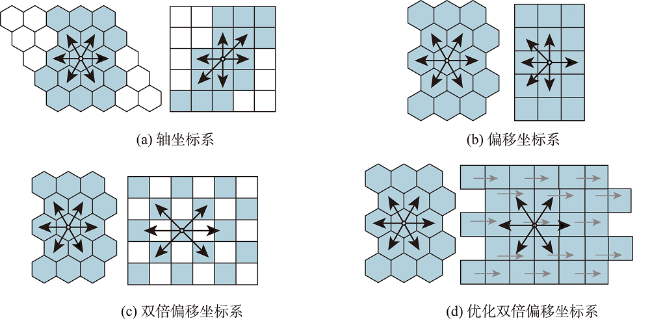
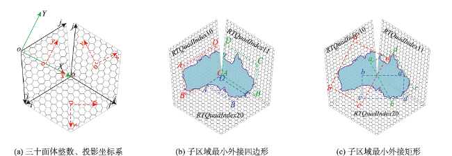
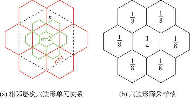
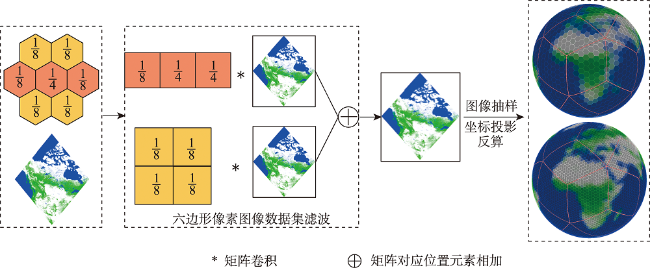
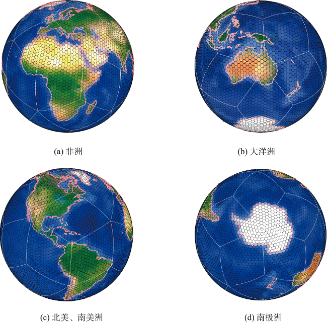
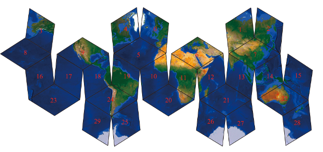
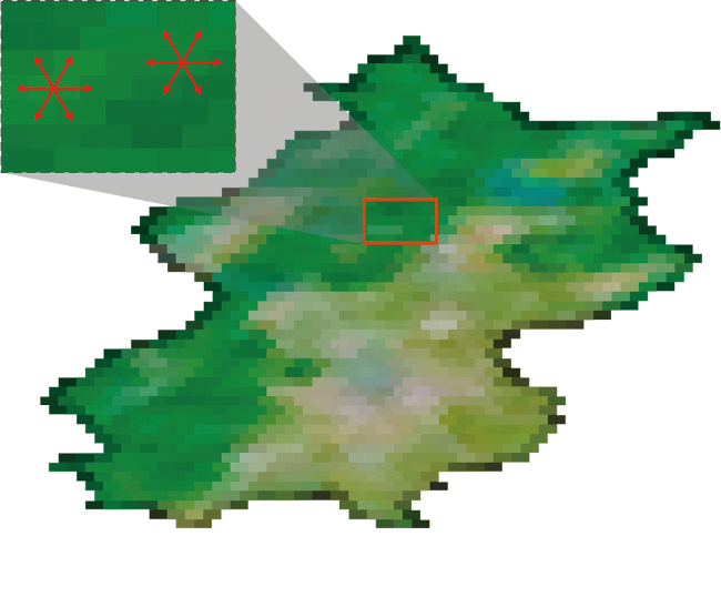
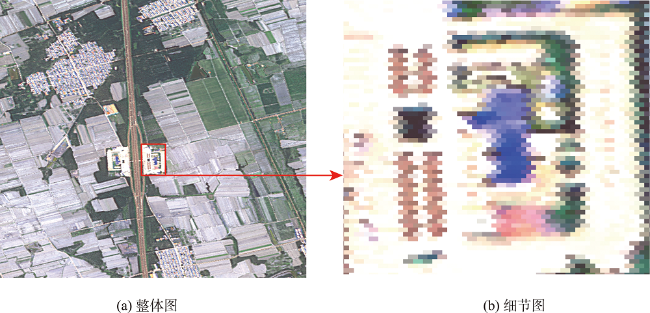
The explosive growth of multisource Remote Sensing (RS) data poses challenges to the application of fusion analysis. Discrete Global Grid System (DGGS) is a digital earth reference model supporting integration and analysis of multisource and multiscale geospatial data. In this study, a Rhombic Triacontahedron (RT) hexagonal DGGS is chosen as the basic digital framework to improve the overall fitting accuracy to the Earth and the spatial sampling efficiency of the grid which is conceptually equivalent to pixel. A mathematical model of hexagonal pixels of RS images is established, and the storage scheme of hexagonal pixels compatible with open-standard format is also proposed. First, the RS images are gridded according to the geographical location, and the hexagonal DGGS modeling of RS image was completed. Secondly, a rigorous correspondence between hexagon and rectangular pixels is established geometrically to preserve the neighborhood information of hexagon pixels by improving the way of double offset coordinates mapped to the rectangular array. Then, the GeoTIFF open-standard format is used to accurately store the hexagonal pixel values, projection and transformation parameters. Finally, a multiscale hexagonal DGGS generation algorithm based on the hexagonal DGGS standard dataset is designed. Experiment results show that using RT hexagonal equal area grid to organize global scale RS images can realize uniform sampling of global data, ensure the overall consistency of cells in different latitudes, avoid drastic changes of cells in high latitudes, and be more suitable for global scale data processing and analysis. The proposed storage scheme can not only ensure that the hexagon pixel RS image dataset is compatible with the standard file format, but also ensure that the rectangular pixels correspond to the hexagon pixels one by one. Hexagonal pixels could be stored in the open-standard format GeoTIFF with a fixed pattern in the form of rectangular arrays for data access, with transformation parameters and metadata used to reconstruct the hexagons. The image information and spatial distribution characteristics of hexagonal DGGS data are preserved well, which is more advantageous than the Soil Moisture and Ocean Salinity (SMOS) data organization scheme. This scheme break through the hexagonal with rectangular pixels in RS image data organization barriers, GIS/RS software that can be read using common hexagon pixels in RS image, and can complete the hexagonal pixels by the operation of the rectangular pixel equivalent processing, is expected to promote hexagon global discrete grid systems in RS data organization, processing, sharing, and other applications.
LIANG Qishuang , CHEN Yihang , BEN Jin , ZHOU Jianbin , DING Junjie , DAI Jinchi . Modelling and Storage Method for Hexagonal Remote Sensing Images in Rhombic Triacontahedron Discrete Global Grid System[J]. Journal of Geo-information Science, 2023 , 25(12) : 2361 -2373 . DOI: 10.12082/dqxxkx.2023.230425
表1 三十面体六边形全球离散格网不同层次分辨率Tab. 1 Resolution at different levels of the RT hexagonal DGGS |
| 格网层次 | … | 9 | 10 | 11 | 12 | 13 | 14 |
|---|---|---|---|---|---|---|---|
| 单元平均面积/km2 | … | 65.100 80 | 16.275 20 | 4.066 24 | 1.019 35 | 0.254 88 | 0.063 72 |
表2 部分地理键值的设置及含义Tab. 2 Settings and meanings of some geographic key values |
| GeoTIFF格式标签 | 数值 | 标签说明 |
|---|---|---|
| ModelPixelScaleTag | (b1, b2, 0) | 用于定义像素在地理坐标系统中的缩放比例 |
| ModelTiepointTag | (0, 0, xa, ya, 0) | 用于定义图像像素和地理坐标之间的映射关系 |
| GTCitationGeoKey | “三十面体Leeuwen等积多面体投影相关信息描述” | 提供所使用的坐标系、投影方法或其他详细信息 的描述 |
| GTRasterTypeGeoKey | 2 | 表示不同类型栅格数据(1:表示灰度栅格;2:表示彩色栅格;3:表示伪彩色图像;4:表示透明度掩码) |
| GeographicTypeGeoKey | 投影坐标系 | 图像地理坐标系类型 |
| ProjectedCSTypeGeoKey | 自定义(例26917:UTM Zone 17N) | 指定投影坐标系类型 |
| [1] |
|
| [2] |
|
| [3] |
周良辰, 盛业华, 林冰仙, 等. 球面菱形离散格网正二十面体剖分法[J]. 测绘学报, 2014, 43(12):1293-1299.
[
|
| [4] |
林冰仙, 许德朋, 盛业华, 等. 正二十面体球面菱形离散格网的编码模型及其映射方法[J]. 测绘学报, 2016, 45(S1):23-31.
[
|
| [5] |
周建彬, 贲进, 王蕊, 等. 四孔六边形全球离散格网一致瓦片层次结构编码运算[J]. 武汉大学学报·信息科学版, 2023, 48(4):639-646.
[
|
| [6] |
王蕊, 贲进, 梁晓宇, 等. 菱形三十面体格网系统构建的等积投影方法研究[J]. 武汉大学学报·信息科学版, 2023.
[
|
| [7] |
|
| [8] |
|
| [9] |
郑明阳, 贲进, 周建彬, 等. 局部区域多孔径六边形格网系统快速生成算法[J]. 武汉大学学报·信息科学版, 2022, 47(9):1376-1382.
[
|
| [10] |
贲进, 童晓冲, 汪磊, 等. 利用球面离散格网组织空间数据的关键技术[J]. 测绘科学技术学报, 2010, 27(5):382-386.
[
|
| [11] |
张继凯, 聂俊岚, 陈贺敏, 等. 基于菱形块四叉树的全球六边形网格实时绘制方法[J]. 计算机辅助设计与图形学学报, 2017, 29(10):1824-1834.
[
|
| [12] |
|
| [13] |
|
| [14] |
|
| [15] |
|
| [16] |
梁晓宇, 贲进, 周建彬, 等. 菱形三十面体六边形全球离散格网系统构建算法[J]. 地理与地理信息科学, 2023, 39(2):8-16.
[
|
| [17] |
|
| [18] |
|
| [19] |
|
| [20] |
|
| [21] |
贲进, 张永生, 童晓冲. GeoTIFF解析及在遥感影像地理编码中的应用[J]. 信息工程大学学报, 2005, 6(1):94-98.
[
|
/
| 〈 |
|
〉 |
