
Journal of Geo-information Science >
Research Progress of Cartography Highlighted by the 31st International Cartographic Conference
Received date: 2024-01-02
Revised date: 2024-01-15
Online published: 2024-03-26
Supported by
National Key Research and Development Program of China(2022YFC3005700)
the Basic Scientific Research Foundation of the Chinese Academy of Surveying and Mapping(AR2205)
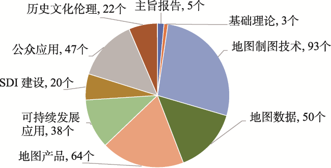
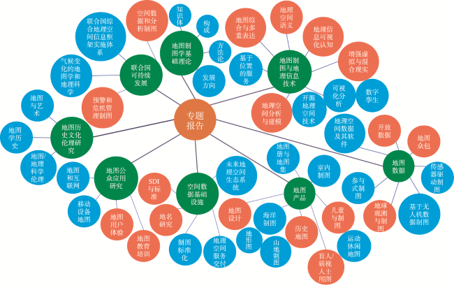
The 31st International Cartography Conference (ICC) was held in Cape Town, South Africa from August 13 to August 18 in 2023. This paper first introduced the overview of the 31st ICC, the participation of Chinese experts and enterprise. Secondly, based on the technical reports during the ICC2023, new research hotspots of cartography were analyzed and summarized from eight aspects including the basic theory of cartography and technologies of cartography, map data, map products, and Spatial Data Infrastructure (SDI) construction, public applications, sustainable development applications and historical and cultural ethics. We concluded some obvious hotspots that the traditional mapping fields have paid more attention to multi-element fusion mapping, user and scenario experience enhancement and rapid mapping capabilities; On the other hand, the emerging geographical information fields have focused on multi-modal ubiquitous sensing, big data fusion processing, artificial intelligence analysis, knowledge construction and services which have been deepened continuously; In addition, government agencies, scientific research institutions, industrial enterprises across the world have continuous passion on global, regional, national and urban sustainable development cartographic applications for resource management, ecological protection, social development. Subsequently, the new characteristics of map visualization methods from the award-winning maps were explored as well which incorporate more modern elements and cultural imprints, and emphasize people-map interaction. Afterwards, in the era of big data and artificial intelligence, the development trend of theoretical systems, technical methods and application services for cartography in the next few years are discussed. That is, the theoretical system of cartography becomes more professional and refined. In the era of artificial intelligence, the technical content of cartography becomes more knowledgeable. Cartography application services become more ubiquitous driven by big data. Cartography plays a more profound role in supporting the sustainable development of the United Nations. In the last place, some suggestions were put forward for the development of the cartography discipline in China. For example, in the future, we must make full use of the ICA international platform to continuously establish and improve a new theoretical system of cartography in the intelligent era, break through the key core technologies of cartography, and promote the high-quality development of cartography in our country with a global perspective. Meanwhile, we should pay more attention to the international frontier developments in important and emerging research fields such as geospatial data fusion, knowledge construction, spatial analysis, ubiquitous mapping, geographic intelligence, and data quality, and strengthen scientific and technological exchanges and cooperation between relevant domestic and foreign research institutions. A more proactive and proactive opening-up strategy should be implemented to promote the continuous improvement of the international influence of cartography research.

LIU Jiping , CHE Xianghong , WANG Yong , Xu Shenghua , SUN Yujie , CHI Jinzhe , DU Kaixuan . Research Progress of Cartography Highlighted by the 31st International Cartographic Conference[J]. Journal of Geo-information Science, 2024 , 26(1) : 3 -14 . DOI: 10.12082/dqxxkx.2024.230788
表1 不同类型地图可视化特点Tab. 1 Visualization characteristics of different types of maps |
| 序号 | 地图类型 | 地图特点 |
|---|---|---|
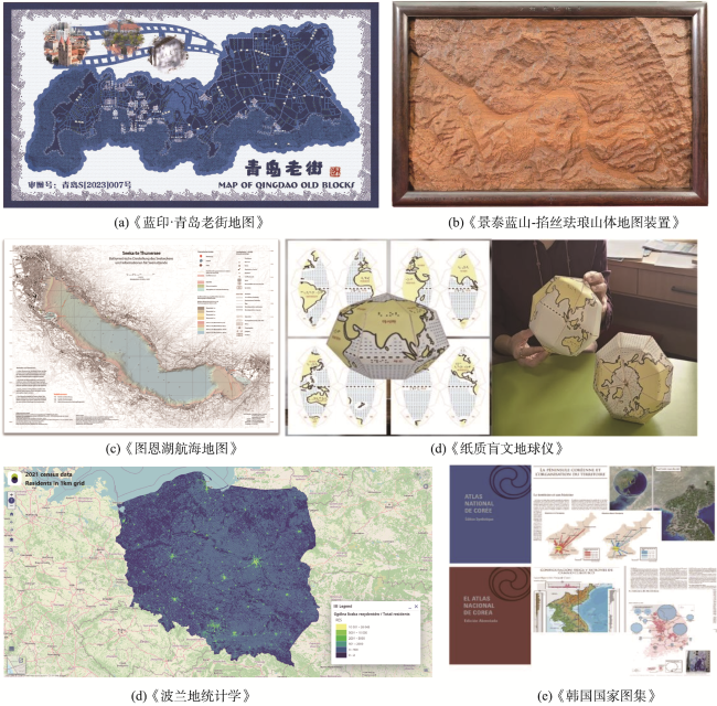
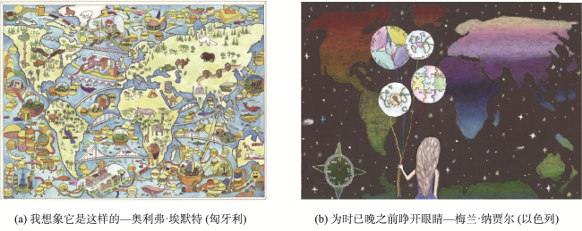
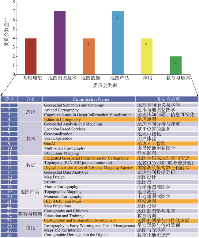
| 1 | 挂图类 | 结合传统绘画艺术和文字、音乐、语音和摄影等现代艺术和文学作品等文字、图片、音频、视频等多种信息展示手段,使得地图可视化更加生动,在地图空间定位等基本功能基础上,更加突出地图的艺术美感(图4(a)—图4(b)) |
| 2 | 故事类 | |
| 3 | 实体类 | |
| 4 | 航空(海)类 | 为全力保障航空、海运安全性,可视化与飞行和航海相关的地理要素和航行要素类型更为细化,如注重海洋和陆地地形地貌等可视化表达(图4(c)) |
| 5 | 地图集(册)类 | 相比传统的静态制图,结合多源大数据更加主动自然、社会和人文等地理现象时空变化的地图可视化表达(图4(f)) |
| 6 | 教育类 | 相比传统纸质制图介质,结合数字化与物理等多元化介质,让地图教育更加常态化;地图制图从传统2D模式向3D和4D模式转化,更加注重地图交互性,地图用户群体更加广泛(图4(d)) |
| 7 | 数字地图及服务类 | 更加关注WEB端时空大数据的快速在线分析和可视化,制图过程可快速个性定制和自适应 (图4(e)) |
图4 国际地图大赛部分获奖作品注:数据来源: https://icc2023.org/index.php/international-map-exhibition/。 Fig. 4 Parts of the award-winning works from the International Map Exhibitions |
| [1] |
|
| [2] |
|
| [3] |
|
| [4] |
|
| [5] |
|
| [6] |
|
| [7] |
|
| [8] |
|
| [9] |
|
| [10] |
|
| [11] |
|
| [12] |
|
| [13] |
|
| [14] |
|
| [15] |
|
| [16] |
|
| [17] |
|
| [18] |
|
| [19] |
|
| [20] |
|
| [21] |
|
| [22] |
|
| [23] |
|
| [24] |
|
| [25] |
|
| [26] |
|
| [27] |
|
| [28] |
|
| [29] |
|
| [30] |
|
| [31] |
|
| [32] |
|
| [33] |
|
| [34] |
|
| [35] |
艾廷华. 深度学习赋能地图制图的若干思考[J]. 测绘学报, 2021, 50(9):1170-1182.
[
|
| [36] |
|
| [37] |
钱海忠, 武芳, 王家耀. 自动制图综合及其过程控制的智能化研究[M]. 北京: 测绘出版社, 2012.
[
|
| [38] |
王米琪. 基于图卷积神经网络的道路网模式识别[D]. 武汉: 武汉大学, 2021.
[
|
| [39] |
李想, 李宏伟. 深度学习方法在地图点注记配置中的应用研究[J]. 出版与印刷, 2022(2):49-56.
[
|
| [40] |
于洋洋, 贺康杰, 武芳, 等. 面状居民地形状分类的图卷积神经网络方法[J]. 测绘学报, 2022, 51(11):2390-2402.
[
|
| [41] |
钟英铭. 基于深度学习的面向制图综合的建筑物群组模式识别研究[D]. 武汉: 华中师范大学, 2021.
[
|
| [42] |
|
| [43] |
|
| [44] |
黄楠. 基于DEM及风格迁移的地形水墨风格艺术化表达[D]. 南京: 南京师范大学, 2021.
[
|
| [45] |
|
| [46] |
|
| [47] |
|
| [48] |
|
| [49] |
|
| [50] |
|
| [51] |
|
| [52] |
|
| [53] |
|
| [54] |
|
| [55] |
刘艳芳, 方飞国, 刘耀林, 等. 时空大数据在空间优化中的应用[J]. 测绘地理信息, 2019, 44(3):7-20.
[
|
| [56] |
刘纪平, 王勇, 张福浩, 等. 网络地理信息获取融合与分析挖掘[M]. 北京: 测绘出版社, 2018.
[
|
| [57] |
|
| [58] |
|
| [59] |
裴韬, 黄强, 王席, 等. 地理大数据聚合的内涵、分类与框架[J]. 遥感学报, 2021, 25(11):2153-2162.
[
|
| [60] |
|
| [61] |
刘纪平, 王勇, 胡燕祝, 等. 互联网泛在地理信息感知融合技术综述[J]. 测绘学报, 2022, 51(7):1618-1628.
[
|
| [62] |
|
| [63] |
陈军, 闫超德, 赵仁亮, 等. 基于Voronoi邻近的移动地图自适应裁剪模型[J]. 测绘学报, 2009, 38(2):152-155,161.
[
|
| [64] |
王家耀, 张天时. 制图综合[M]. 北京: 星球地图出版社, 2016.
[
|
| [65] |
戴志伟. 寻路大数据:海量数据与大规模分析[J]. 中国信息化, 2014,(S2):113.
[
|
| [66] |
廖克. 中国地图学发展的回顾与展望[J]. 测绘学报, 2017, 46(10):1517-1525.
[
|
| [67] |
|
| [68] |
|
| [69] |
|
| [70] |
|
| [71] |
|
/
| 〈 |
|
〉 |