
Journal of Geo-information Science >
Opportunities and Challenges of Cartography Research Driven by New Generation Artificial Intelligence
Received date: 2024-01-03
Revised date: 2024-01-15
Online published: 2024-03-26
Supported by
Strategic Priority Research Program of the Chinese Academy of Sciences(XDB0740100)
National Key Research and Development Program of China(2022YFC3002804)
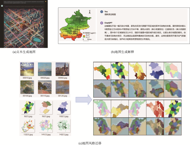
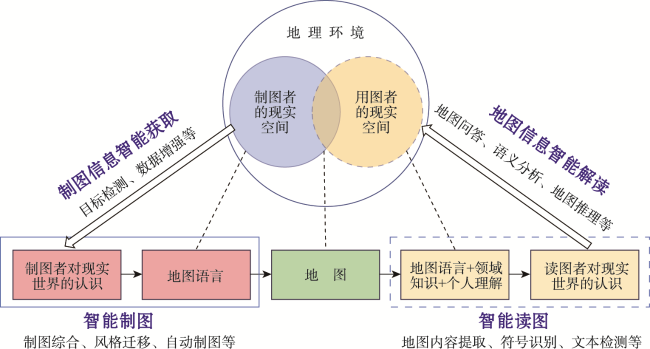
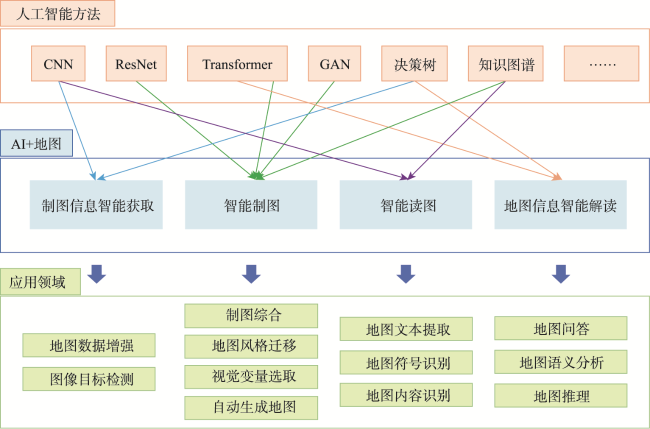
As Artificial Intelligence Generated Content(AIGC) rapidly advances, various disciplines are shifting toward AI-driven scientific research. GeoAI technology, which focuses on geographic spatial intelligence, has the potential to outperform traditional methods in solving cartographic tasks. This shift presents both new opportunities and challenges for cartography. Despite some progress in integrating AI into cartographic research, limitations in computational power and other factors have hindered significant success in the past. As we enter the era of intelligence, both humans and machines will play critical roles in map creation and interpretation. Through artificial intelligence algorithms, maps can be produced quickly, at low cost, and on a large scale. However, there are also issues such as the instability of the quality of map works. The generation of map content has gone through the stages of expert-generated content and user-generated content and is developing towards the stage of artificial intelligence-generated content. In the traditional map-making phase, professional maps are produced by cartographic experts. While the quality of these maps is assured, the number of experts is limited. Consequently, the production cycle is long, the cost is high, the quantity of map products is limited, and they have not been produced on a large scale. At the current stage, generative artificial intelligence can produce map content in three forms: text-to-map (txt2map), map-to-text explanation (map2txt), and map style transfer (map2map). People can already use ChatGPT to generate maps by entering a piece of text, produce a textual explanation of a map by uploading an image of the map to ChatGPT, and even achieve map style transfer from images using Generative Adversarial Networks (GANs). The integration of artificial intelligence with the map transmission model has derived an intelligent map transmission model. It includes four stages: (1) Intelligent acquisition of mapping information: Sampling and collecting information about the real-world geographical environment through artificial intelligence methods, which is then processed and filtered into structured information for mapping; (2) Intelligent mapping: The process of intelligently generating maps through the use of colors, symbols, grading, and other representational methods based on mapping information; (3) Intelligent map reading: The process by which readers use artificial intelligence methods, combined with map language, domain knowledge, and personal understanding, to recognize the real world; (4) Intelligent interpretation of map information: Using artificial intelligence to interpret maps, thereby gaining cognition and understanding of the real world. Although progress has been made, research on using intelligent methods to address cartographic challenges is still in its early stages. Challenges include the lack of comprehensive training datasets, limited model algorithm generalization, and interpretability. These areas offer promising directions for future development.

Key words: AIGC; AI Cartography; GeoAI; AI Map Reading; AI Map Making
ZHANG An , ZHU Junkai . Opportunities and Challenges of Cartography Research Driven by New Generation Artificial Intelligence[J]. Journal of Geo-information Science, 2024 , 26(1) : 35 -45 . DOI: 10.12082/dqxxkx.2024.240128
表1 地图内容生产模式的发展特征Tab. 1 Development feature of map content generation modes |
| 阶段 | 特点 | 创作主体 | 规模 | 效率 | 质量 | 成本 |
|---|---|---|---|---|---|---|
| PGC地图 | 专家生成内容 | 地图专家 | 小 | 生成慢 | 高 | 高 |
| UGC地图 | 用户生成内容 | 用户 | 大 | 生成快 | 低 | 低 |
| AIGC地图 | 人工智能生成内容 | 人+机器 | 大 | 生成快 | 不稳定 | 低 |
| [1] |
陈述彭. 地图学面临的挑战与机遇[J]. 地理学报, 1994, 49(1):1-8.
[
|
| [2] |
周成虎. 全息地图时代已经来临——地图功能的历史演变[J]. 测绘科学, 2014, 39(7):3-8.
[
|
| [3] |
郭仁忠, 陈业滨, 赵志刚, 等. 泛地图学理论研究框架[J]. 测绘地理信息, 2021, 46(1):9-15.
[
|
| [4] |
|
| [5] |
Openai,
|
| [6] |
|
| [7] |
王飞跃, 缪青海, 张军平, 等. 探讨AI for Science的影响与意义:现状与展望[J]. 智能科学与技术学报, 2023, 5(1):1-6.
[
|
| [8] |
|
| [9] |
刘瑜, 郭浩, 李海峰, 等. 从地理规律到地理空间人工智能[J]. 测绘学报, 2022, 51(6):1062-1069.
[
|
| [10] |
高松. 地理空间人工智能的近期研究总结与思考[J]. 武汉大学学报(信息科学版), 2020, 45(12):1865-1874.
[
|
| [11] |
王家耀, 武芳, 闫浩文. 大变化时代的地图学[J]. 测绘学报, 2022, 51(6):829-842.
[
|
| [12] |
陈述彭. 新型地图产品前瞻[J]. 地球信息科学, 2005, 7(2):8-10.
[
|
| [13] |
History of artificial intelligence[Z/OL]// Wikipedia. (2024-03-10)[2024-03-17]. https://en.wikipedia.org/w/index.php?title=History_of_artificial_intelligence&oldid=1212891261
|
| [14] |
吴忠性. 地图学一个新的分支学科:制图领域专家系统正在我国形成[J]. 地图, 1994(4):14-16.
[
|
| [15] |
|
| [16] |
|
| [17] |
|
| [18] |
孙群. 专家系统以及它在地图制图领域中的应用[J]. 解放军测绘学院学报, 1992, 9(1):67-73.
[
|
| [19] |
王家耀, 吴战家, 武芳. 制图综合专家系统工具研究[J]. 解放军测绘学院学报, 1992, 9(4):66-72.
[
|
| [20] |
|
| [21] |
孙群. 地图投影选择和应用问题的专家系统实现[J]. 解放军测绘学院学报, 1994, 11(4):289-295.
|
| [22] |
华一新. 用专家系统技术确定地图要素的表示等级[J]. 测绘通报, 1993(3):22-25.
[
|
| [23] |
|
| [24] |
艾廷华. 深度学习赋能地图制图的若干思考[J]. 测绘学报, 2021, 50(9):1170-1182.
|
| [25] |
任福, 翁杰, 王昭, 等. 关于智能地图制图的几点思考[J]. 武汉大学学报(信息科学版), 2022, 47(12):2064-2068.
[
|
| [26] |
|
| [27] |
|
| [28] |
|
| [29] |
|
| [30] |
|
| [31] |
|
| [32] |
|
| [33] |
|
| [34] |
|
| [35] |
|
| [36] |
廖克. 现代地图学[M]. 北京: 科学出版社, 2003.
[
|
| [37] |
|
| [38] |
高博, 赵军喜. 基于计算机的地图传输理论[J]. 地图, 2000(3):5-8.
[
|
| [39] |
|
| [40] |
|
| [41] |
|
| [42] |
|
| [43] |
|
| [44] |
|
| [45] |
|
| [46] |
|
| [47] |
|
| [48] |
|
| [49] |
|
| [50] |
|
| [51] |
|
| [52] |
|
| [53] |
|
| [54] |
|
| [55] |
|
| [56] |
|
| [57] |
|
| [58] |
韩杨丽. 基于流形学习的地图颜色自动转移方法研究[D]. 南京: 南京师范大学, 2020.
[
|
| [59] |
吴明光, 孙彦杰, 闾国年. 地图风格迁移: 概念、综述与展望[J]. 武汉大学学报(信息科学版), 2022, 47(12):2069-2084.
[
|
| [60] |
|
| [61] |
|
| [62] |
杨启和, 朱文忠, 黄文骞. 地图模式识别研究的介绍与展望[J]. 测绘科技通讯, 1996(3):16-20.
[
|
| [63] |
周熙然, 李德仁, 薛勇, 等. 地图图像智能识别与理解:特征、方法与展望[J]. 武汉大学学报(信息科学版), 2022, 47(5):641-650.
[
|
| [64] |
|
| [65] |
|
| [66] |
|
/
| 〈 |
|
〉 |