
Journal of Geo-information Science >
Application of Random Forest Algorithm in Regional Ecotourism Suitability Assessment
Received date: 2023-04-16
Revised date: 2023-07-03
Online published: 2024-03-27
Supported by
National Natural Science Foundation of China(41171342)
Key Project of Hunan Provincial Education Department(17A127)
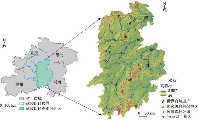
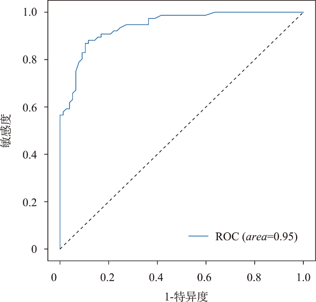
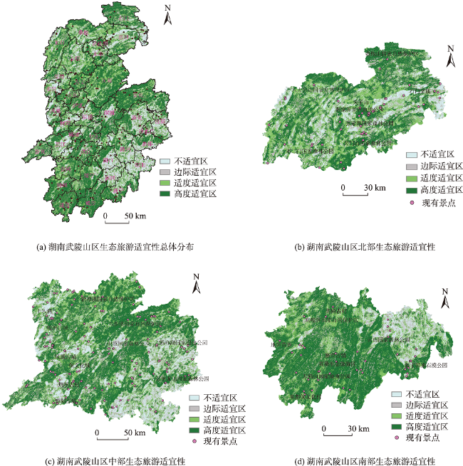
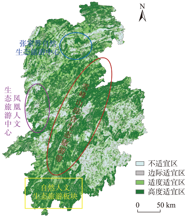
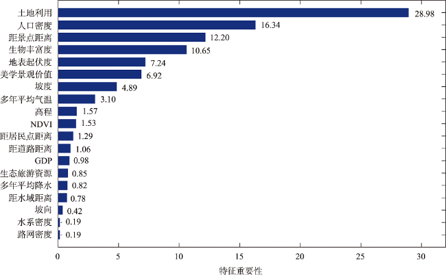
The ecotourism suitability assessment is the basis and a crucial reference for evaluating development potential, formulating plans, and implementing exploitation in ecotourism. In this study, we first analyze the feasibility of machine learning methods for modeling ecotourism suitability, and the Random Forest (RF) algorithm is selected for conducting an empirical study in the Wuling Mountain area in Hunan Province. In the study area, there are abundant tourism resources with an urgent need for ecotourism development, which can not only consolidate and expand the achievements of poverty alleviation, but also effectively connect with rural revitalization, thereby promoting sustainable development of tourism. The results show that: (1) Machine learning, as a new regional ecotourism suitability assessment approach, provides new insights and solutions for further improvement of suitability assessment; (2) The RF algorithm as a typical machine learning method can be effectively applied in the regional ecotourism suitability assessment. The optimized RF model achieves an average testing accuracy of 86.49%, with an area under the curve (AUC) of 0.95. These results also indicate the ecotourism suitability of the Wuling Mountain area in Hunan Province; (3) The ranking of feature importance reveals that land use type contributes most to the model, accounting for 28.98%, followed by other significant factors including population density (16.34%), distance from scenic spots (12.2%), and biological richness (10.65%). The above factors should be all considered in ecotourism development efforts; (4) The ecotourism suitability results show a high proportion of highly and moderately suitable areas, suggesting significant potential for ecotourism development in the study area. Based on the ecotourism suitability assessment, different development directions are proposed: A protective pattern and experiential education-oriented ecotourism are well-suited in highly suitable areas; a joint pattern and supportive ecotourism are appropriate for moderately suitable areas; a restrictive pattern is recommended for marginally suitable areas; and for unsuitable areas, the development should be prohibited. Finally, we present a new development strategy known as "two centers, one belt, and one plate," providing theoretical and technical guidance for ecotourism development and the consolidation of poverty alleviation achievements in the Wuling Mountain area of Hunan Province.
TAN Cui , HUANG Qin , YANG Bo , LI Tao , LEI Jihua . Application of Random Forest Algorithm in Regional Ecotourism Suitability Assessment[J]. Journal of Geo-information Science, 2024 , 26(2) : 318 -331 . DOI: 10.12082/dqxxkx.2024.230198
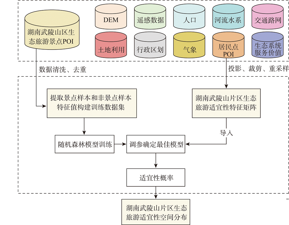
表1 数据来源Tab. 1 Data Sources |
| 数据类型 | 数据年份 | 数据来源 | 数据描述 |
|---|---|---|---|
| 景点、居民点POI数据 | 2022 | 百度地图API数据开放接口 | 经数据清洗得到255个景点 |
| DEM数据 | 2019 | 地理空间数据云 (http://www.gscloud.cn/) | ASTER GDEM V3 30 m空间分辨率,反映区域高程信息 |
| 人口数据 | 2020 | WORLDPOP全球高分辨率人口计划项目数据集 (www.worldpop.org/) | 空间分辨率为3弧度,在赤道处约为100 m |
| 遥感数据 | 2020 | 地理空间数据云 (http://www.gscloud.cn/) | 30 m Landsat 8 OLI_TIRS 数据,用以计算归一化植被指数(NDVI) |
| 路网数据 | 2020 | OSM(www.openstreetmap.org) | 反映交通状况,计算道路密度与距道路距离 |
| 河流水系数据 | 2020 | 全国地理信息资源目录服务系统 (http://www.webmap.cn) | 反映水系状况,计算距水域距离与水系密度 |
| 土地利用数据 | 2020 | 30 m全球地表覆盖数据GlobelLand30 (http://www.globallandcover.com/) | 30 m空间分辨率,反映地表覆盖状况 |
| 行政区划数据 | 2020 | 中国科学院资源环境科学数据中心 (http://www.resdc.cn/) | 研究区行政边界,通过矢量底图掩膜出各特征因子栅格 |
| 气象数据 | 2020 | 中国气象要素年度空间插值数据集 (http://www.resdc.cn/DOI) | 多年平均气温、降水数据 |
| 生态系统服务价值数据 | 2020 | 中国陆地生态系统服务价值空间分布数据集 (http://www.resdc.cn/DOI) | 生物丰富度、美学景观价值数据 |
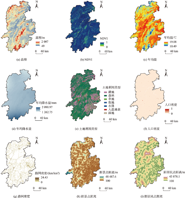
表2 湖南武陵山片区生态旅游适宜性特征选择Tab. 2 Features selection of ecotourism suitability of Wuling Mountain area in Hunan |
| 影响因素 | 特征选取 | 特征说明 | 计算方法 |
|---|---|---|---|
| 生态旅游自然环境 | NDVI | 反映区域的植被覆盖程度,值越大 表示自然环境越好 | ENVI 5.3 处理遥感影像波段得到: NIR(近红外)-IR(红外波段)/NIR+IR |
| 地形起伏度 | 影响自然景观形态特征 | ArcGIS 邻域分析DEM得出 | |
| 坡度 | 影响植被生长,坡度越缓越适宜 | ArcGIS 坡度分析 | |
| 坡向 | 影响自然生态景观格局 | ArcGIS 坡向分析 | |
| 高程 | 影响气候因子与人类活动 | DEM值 | |
| 水系密度 | 水系是构成自然生态景观的重要元素 | 水系密度=水系长度/区域面积,利用ArcGIS 进行计算 | |
| 距水域距离 | 反映利用水源的便利程度,对休闲旅游有重要作用 | ArcGIS 距离分析工具,采用欧式距离 | |
| 气温 | 多年平均气温,影响舒适度及停留时间 | 从已出版数据集获取 | |
| 降水 | 多年平均降水,影响停留时间与路线选择 | 从已出版数据集获取 | |
| 生态旅游资源禀赋 | 土地利用类型 | 不同土地利用类型其环境承载力不同 | 从已有数据集中获取 |
| 生物丰富度 | 生物丰度越高,生态旅游资源越丰富 | 从已出版数据集获取 | |
| 生态旅游资源密度 | 生态旅游资源密度越大资源禀赋越高 | ArcGIS 点密度计算工具 | |
| 美学景观价值 | 反映自然景观的美学价值,价值越高资源禀赋越高 | 从已出版数据集获取 | |
| 生态旅游开发条件 | 人口密度 | 反映区域的接待能力与消费规模 | 从已有数据集中获取 |
| 距居民点距离 | 反映区域的偏远程度,距离居民点越近, 越有利于获得相关设备设施服务,更好的区位依托 | ArcGIS 距离分析工具,采用欧式距离 | |
| GDP | 人均GDP,反映经济发展水平,是开发的重要条件 | 从已有数据集中获取 | |
| 路网密度 | 反映区域公路发展水平及交通的良好互联, 密度越大交通越便利 | 路网密度=道路长度/区域面积,利用ArcGIS 进行计算 | |
| 距道路距离 | 距道路越近,可达性越强,越利于开发 | ArcGIS 距离分析工具,采用欧式距离 | |
| 距景点距离 | 反映对现有景点的依托能力,距现有景点越近, 依托能力越强,利于开发 | ArcGIS 距离分析工具,采用欧式距离 |
| [1] |
|
| [2] |
|
| [3] |
|
| [4] |
|
| [5] |
|
| [6] |
|
| [7] |
黄圣霞. 基于AHP的广西十万大山森林生态旅游养老适宜性评价[J]. 河池学院学报, 2018, 38(3):53-59.
[
|
| [8] |
石丹, 刘晓霞. 基于模糊层次分析法的森林生态旅游景区开发潜力评价——以吉林省4个典型森林生态景区为例[J]. 桂林理工大学学报, 2021, 41(2):465-470.
[
|
| [9] |
石丹, 杨慧. 基于多层次灰色方法的生态旅游发展潜力评价及实证研究[J]. 中国农业资源与区划, 2019, 40(2):40-48.
[
|
| [10] |
周秋文, 方海川, 苏维词. 基于GIS和神经网络的川西高原生态旅游适宜度评价[J]. 资源科学, 2010, 32(12):2384-2390.
[
|
| [11] |
|
| [12] |
|
| [13] |
|
| [14] |
|
| [15] |
|
| [16] |
|
| [17] |
|
| [18] |
|
| [19] |
|
| [20] |
|
| [21] |
李悦铮, 牟方元, 梁娟. 湿地旅游资源评价指标体系构建与应用[J]. 经济地理, 2019, 39(1):192-197.
[
|
| [22] |
莫莉秋. 海南省乡村旅游资源可持续发展评价指标体系构建[J]. 中国农业资源与区划, 2017, 38(6):170-177.
[
|
| [23] |
李莹. 浙江省农业生态旅游资源评价指标体系构建[J]. 中国农业资源与区划, 2018, 39(11):178-182.
[
|
| [24] |
廉同辉, 王金叶, 程道品. 自然保护区生态旅游开发潜力评价指标体系及评价模型——以广西猫儿山国家级自然保护区为例[J]. 地理科学进展, 2010, 29(12):1613-1619.
[
|
| [25] |
赵希勇, 闫金娟, 马建章, 等. 自然保护区生态旅游开发适宜性尺度评价模型及其应用[J]. 野生动物学报, 2016, 37(1):67-71.
[
|
| [26] |
吕建树, 刘洋, 张祖陆, 等. 鲁北滨海湿地生态旅游资源开发潜力评价及开发策略[J]. 资源科学, 2011, 33(9):1788-1798.
[
|
| [27] |
丛东来, 于少鹏, 孟博, 等. 湿地资源生态旅游适宜性评价——以黑龙江省79处重点调查湿地为例[J]. 国土与自然资源研究, 2019(4):63-67.
[
|
| [28] |
周彬, 钟林生, 陈田, 等. 基于生态位的黑龙江省中俄界江生态旅游潜力评价[J]. 资源科学, 2014, 36(6):1142-1151.
[
|
| [29] |
徐枫, 王占岐, 张红伟, 等. 随机森林算法在农村居民点适宜性评价中的应用[J]. 资源科学, 2018, 40(10):2085-2098.
[
|
| [30] |
王洪桥, 袁家冬, 孟祥君. 东北地区A级旅游景区空间分布特征及影响因素[J]. 地理科学, 2017, 37(6):895-903.
[
|
| [31] |
陆保一, 张恩伟, 明庆忠. 云南省A级旅游景区空间演化特征及其驱动机制[J]. 山地学报, 2019, 37(6):879-890.
[
|
| [32] |
方叶林, 程雪兰, 王芳. 空气污染与旅游经济的时空关系及影响机理[J]. 经济管理, 2020, 42(1):140-154.
[
|
| [33] |
李会琴, 侯林春, 肖拥军, 等. 基于RS、GIS的黄土高原环境脆弱区生态旅游适宜度评价——以山西省中阳县为例[J]. 测绘科学, 2009, 34(6):300-302.
[
|
| [34] |
陈晓艳, 徐冬, 黄睿. 浙江省县域旅游经济增长的空间溢出效应[J]. 地理科学进展, 2020, 39(9):1512-1521.
[
|
| [35] |
龙飞, 刘家明, 朱鹤. 长三角地区民宿的空间分布及影响因素[J]. 地理研究, 2019, 38(4):950-960.
[
|
/
| 〈 |
|
〉 |