
Journal of Geo-information Science >
Analyzing the Influence of Missing Periods on the Time Dimensional Reconstruction of Summer Land Surface Temperature in the Heihe River Basin Using FY-4A AGRI Data
Received date: 2023-06-19
Revised date: 2023-09-21
Online published: 2024-03-31
Supported by
Fengyun Application Pioneering Project(FY-APP-2022.0204)
Natural Science Foundation of China(42171101)
Natural Science Foundation of China(42271351)
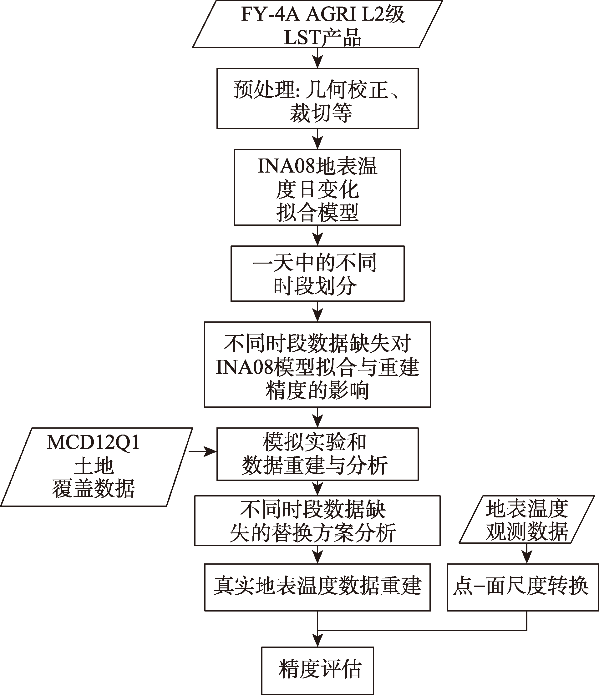
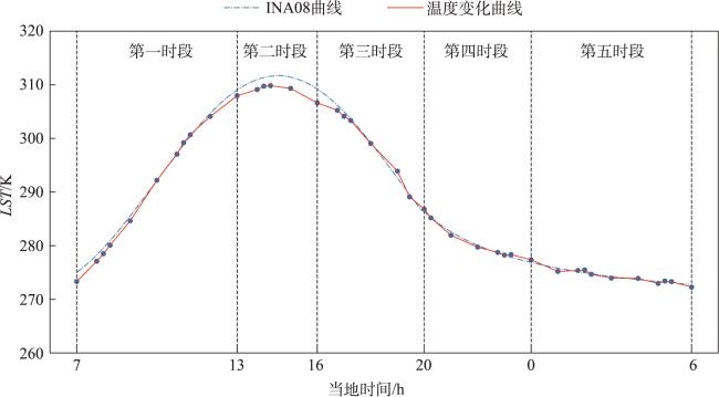
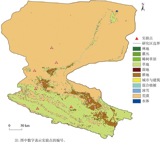
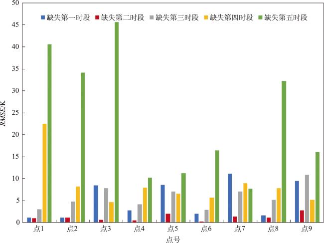
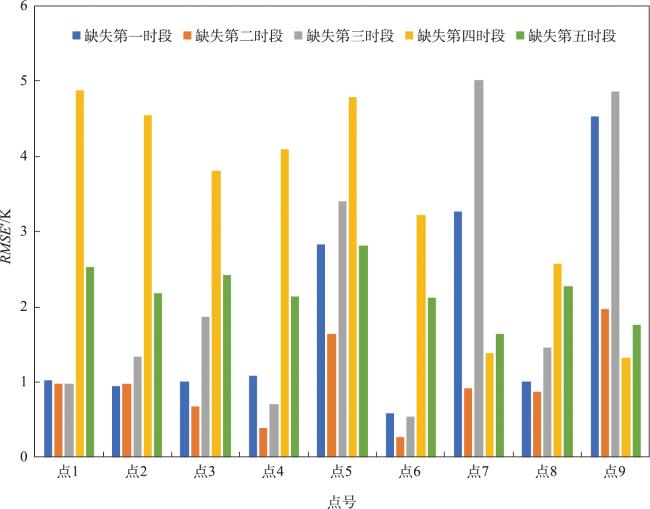
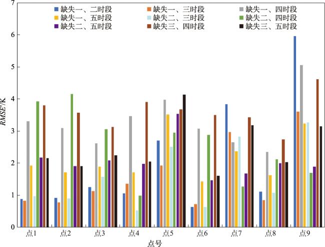
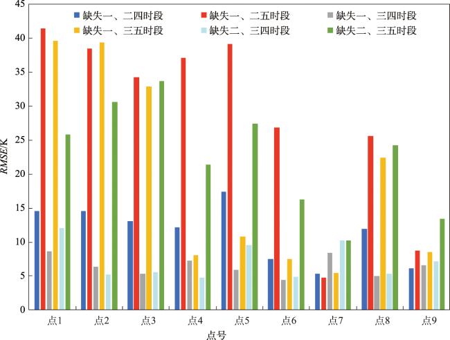
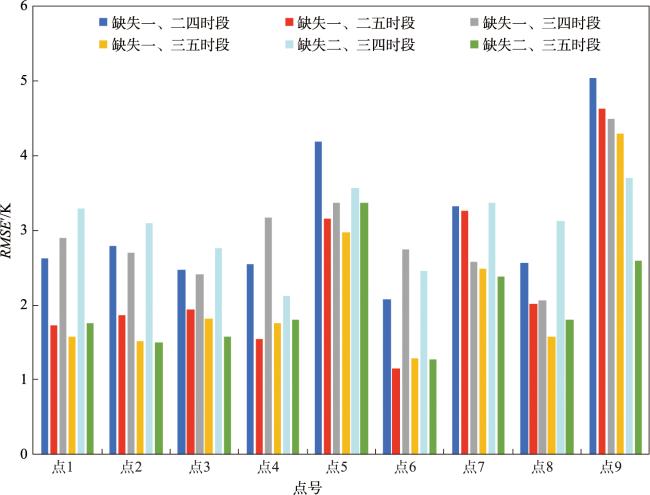
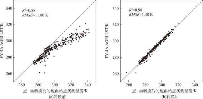
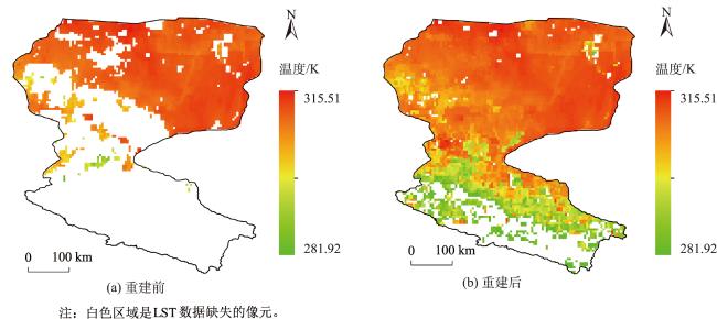
Geostationary meteorological satellite products play a crucial role in various weather monitoring and climate change applications. Due to weather conditions such as cloud cover, precipitation, and atmospheric influence, the Land Surface Temperature (LST) data retrieved from geostationary meteorological satellites often exhibits missing values, which significantly limits the further applications of LST products. In the process of reconstructing missing values of LST using time series data, most of the existing studies focus on comparing the accuracy of different time dimensional reconstruction methods. There has been limited research on evaluating the impact of missing data on the effectiveness of different model reconstruction methods. Taking the Heihe River Basin as the case study area, this study adopts the INA08 Diurnal Temperature Cycle (DTC) model to analyze the impact of missing data on the reconstruction of summer LST data from the FY-4A (Fengyun 4A satellite) AGRI (Advanced Geostationary Orbit Radiation Imager). Then, a data replacement scheme is proposed for different missing time periods, and the LST reconstruction results are verified against field measurement data. Research results show that: (1) the absence of LST data during the second time period (local time of 13:00 to15:00) has a minimal impact on the reconstruction results, while the absence of LST data during the fifth time period (0:00 to 6:00 of the next day) has the most substantial impact on the reconstruction results; (2) with the increasing number of missing time periods, the available original AGRI LST data for fitting the INA08 model are reduced, leading to a decrease in the reconstruction accuracy; (3) the data replacement scheme with the simulation experiment provides valuable guidance for the reconstruction of FY-4A AGRI LST by using the INA08 model, and the reconstruction accuracy of missing data can be significantly improved by replacing certain missing time periods with other suitable time periods. In our study, different time periods are divided based on the daily temperature variation in the Heihe River Basin in the summer season. The time period division may vary depending on the geographical location and season. For a given region and season, appropriate time periods can be determined based on the local sunrise time, the time of maximum daily temperature, and the time of temperature attenuation, in conjunction with typical characteristics of temperature variation throughout the day.
LUO Yumei , ZHU Shanyou , LI Yueli , ZHANG Guixin , XU Yongming . Analyzing the Influence of Missing Periods on the Time Dimensional Reconstruction of Summer Land Surface Temperature in the Heihe River Basin Using FY-4A AGRI Data[J]. Journal of Geo-information Science, 2024 , 26(3) : 709 -724 . DOI: 10.12082/dqxxkx.2024.230339
表1 不同时段数据缺失的替换方案Tab. 1 Replacement scheme for missing data at different time periods |
| 缺失时段个数 | 缺失时段 | 替换方案 |
|---|---|---|
| 1 | 一 | 次日6时替换7时空值 |
| 二 | 不用替换 | |
| 三 | 10时替换19时空值 | |
| 四 | 白天模型计算20时拟合值替换该时刻空值 | |
| 五 | 7时替换次日6时空值 | |
| 2 | 一、二 | 次日6时替换7时空值 |
| 一、三 | 次日6时替换7时空值进行第一次拟合;10时拟合值替换19时空值进行第二次拟合 | |
| 一、四 | 次日6时替换7时空值进行第一次拟合;白天模型计算20时拟合值替换该时刻空值进行第二次拟合 | |
| 一、五 | 白天模型直接进行第一次拟合;白天模型计算7时拟合值替换次日6时进行第二次拟合 | |
| 二、三 | 10时替换19时空值 | |
| 二、四 | 白天模型计算20时拟合值替换该时刻空值 | |
| 二、五 | 7时替换次日6时空值 | |
| 三、四 | 10时替换19时空值进行第一次拟合;白天模型计算20时拟合值替换该时刻空值进行第二次拟合 | |
| 三、五 | 10时替换19时空值,7时替换次日6时空值 | |
| 3 | 一、二、四 | 次日6时替换7时空值进行第一次拟合;白天模型计算20时拟合值替换该时刻空值进行第二次拟合 |
| 一、二、五 | 白天模型直接进行第一次拟合;白天模型计算7时拟合值替换次日6时进行第二次拟合 | |
| 一、三、四 | 次日6时替换7时空值进行第一次拟合;10时拟合值替换19时空值进行第二次拟合;白天模型计算20时拟合值替换该时刻空值进行第三次拟合 | |
| 一、三、五 | 白天模型直接进行第一次拟合;10时拟合值替换19时空值,7时拟合值替换次日6时进行第二次拟合 | |
| 二、三、四 | 10时替换19时空值进行第一次拟合;白天模型计算20时拟合值替换该时刻空值进行第二次拟合 | |
| 二、三、五 | 10时替换19时空值,7时替换次日6时空值 |
表2 真实实验数据与结果Tab. 2 Real experimental data and results |
| 缺失时段 | 日期 | 站点 | AGRI LST与实测值相关性R2 | RMSE | RMSE' |
|---|---|---|---|---|---|
| 1 | 7月11日 | 酒泉 | 0.989 2 | 2.37 | 1.15 |
| 1 | 7月11日 | 张掖 | 0.983 2 | 4.48 | 2.14 |
| 1 | 7月11日 | 临泽 | 0.980 3 | 5.12 | 3.96 |
| 2 | 7月6日 | 临泽 | 0.951 3 | 1.80 | - |
| 2 | 7月17日 | 高台 | 0.985 7 | 0.77 | - |
| 3 | 7月4日 | 肃南 | 0.953 5 | 13.34 | 5.55 |
| 3 | 7月12日 | 托勒 | 0.989 6 | 6.88 | 3.50 |
| 3 | 7月18日 | 祁连 | 0.9711 | 7.17 | 2.09 |
| 4 | 7月22日 | 山丹 | 0.963 4 | 5.47 | 5.12 |
| 5 | 7月8日 | 酒泉 | 0.969 1 | 11.41 | 3.44 |
| 5 | 7月17日 | 民乐 | 0.986 0 | 62.07 | 0.88 |
| 5 | 7月23日 | 鼎新 | 0.968 5 | 60.41 | 1.80 |
| 1、2 | 7月11日 | 民乐 | 0.992 2 | 5.91 | 3.34 |
| 1、2 | 7月16日 | 高台 | 0.996 2 | 9.76 | 1.36 |
| 1、2 | 7月19日 | 额济纳旗 | 0.930 8 | 6.80 | 6.71 |
| 1、3 | 7月11日 | 托勒 | 0.983 7 | 7.25 | 4.64 |
| 2、3 | 7月3日 | 托勒 | 0.995 9 | 7.29 | 3.56 |
| 2、3 | 7月3日 | 肃南 | 0.872 8 | 11.11 | 5.92 |
| 2、3 | 7月3日 | 野牛沟 | 0.976 4 | 7.78 | 4.29 |
| 2、3 | 7月12日 | 野牛沟 | 0.925 7 | 4.30 | 3.93 |
| 2、4 | 7月12日 | 额济纳旗 | 0.982 4 | 3.17 | 2.58 |
| 3、4 | 7月17日 | 肃南 | 0.972 9 | 6.43 | 5.50 |
| 3、4 | 7月22日 | 祁连 | 0.981 4 | 15.26 | 6.04 |
| 3、4 | 7月27日 | 高台 | 0.953 6 | 3.49 | 2.32 |
| 2、3、4 | 7月19日 | 山丹 | 0.645 3 | 5.99 | 3.79 |
| 2、3、4 | 7月19日 | 祁连 | 0.964 9 | 3.89 | 8.14 |
| [1] |
|
| [2] |
|
| [3] |
Karnieli, Arnon, Agam, et al. Use of NDVI and land surface temperature for drought a-ssessment: merits and limitations[J]. Journal of Climate, 2010, 23(3). DOI:10.1175/2009JCLI2900.1
|
| [4] |
|
| [5] |
|
| [6] |
|
| [7] |
|
| [8] |
|
| [9] |
|
| [10] |
|
| [11] |
王爱辉, 杨英宝, 潘鑫, 等. 顾及时空特征的FY-4A云覆盖像元地表温度重建模型[J]. 武汉大学学报(信息科学版), 2021, 46(06):852-862.
[
|
| [12] |
周芳成, 唐世浩, 韩秀珍, 等. 云下遥感地表温度重构方法研究[J]. 国土资源遥感, 2021, 33(1):78-85.
[
|
| [13] |
张军, 覃志豪, 刘梅, 等. 利用空间插值法估算云覆盖像元地表温度的可行性研究[J]. 地理与地理信息科学, 2011, 27(6):45-49,115.
[
|
| [14] |
涂丽丽, 覃志豪, 张军, 等. 基于空间内插的云下地表温度估计及精度分析[J]. 遥感信息, 2011(4):59-63,106.
[
|
| [15] |
周义, 覃志豪, 包刚. GIDS空间插值法估算云下地表温度[J]. 遥感学报, 2012, 16(03):492-504.
[
|
| [16] |
|
| [17] |
鲍瑶, 杨英宝. 长时序无缝地表温度重建方法研究[J/OL]. 遥感技术与应用. https://kns.cnki.net/kcms/detail/62.1099.TP.20230327.1632.002.html.
[
|
| [18] |
|
| [19] |
崔晓临, 程贇, 张露, 等. 基于DEM修正的MODIS地表温度产品空间插值[J]. 地球信息科学学报, 2018, 20(12):1768-1776.
[
|
| [20] |
|
| [21] |
臧琳, 宋冬梅, 甘宇亮, 等. 统计模型与滤波算法的地表温度重建方法探讨[J]. 测绘科学, 2016, 41(7):11-17.
[
|
| [22] |
|
| [23] |
|
| [24] |
|
| [25] |
|
| [26] |
|
| [27] |
|
| [28] |
|
| [29] |
|
| [30] |
|
| [31] |
|
| [32] |
|
| [33] |
陈颖, 段四波, 冷佩, 等. 极轨卫星热红外地表温度日变化模拟[J]. 遥感信息, 2016, 31(6):7-14.
[
|
| [34] |
|
| [35] |
张德军, 杨世琦, 王永前, 等. 基于FY3C地表温度重建的多云地区旱情监测评估[J]. 自然资源学报, 2021, 36(4):1047-1061.
[
|
| [36] |
刘紫涵, 吴鹏海, 吴艳兰, 等. 风云静止卫星地表温度产品空值数据稳健修复[J]. 遥感学报, 2017, 21(1):40-51.
[
|
| [37] |
柯灵红, 王正兴, 宋春桥, 等. 青藏高原东北部MODIS LST时间序列重建及与台站地温比较[J]. 地理科学进展, 2011, 30(7):819-826.
[
|
| [38] |
韩晓勇, 韩玲, 戚鹏程. 秦巴山区MODIS LST时序数据重建及特征分析[J]. 地理与地理信息科学, 2016, 32(1):71-77.
[
|
| [39] |
刘艳, 王锦地, 周红敏, 等. 用地面点测量数据验证LAI产品中的尺度转换方法[J]. 遥感学报, 2014, 18(6):1189-1198.
[
|
| [40] |
吴立宗. 黑河流域研究区边界:国家冰川冻土沙漠科学数据中心(www.ncdc.ac.cn).
[
|
/
| 〈 |
|
〉 |
