
Journal of Geo-information Science >
Research Status and Prospects of Geospatial Information Technology for Urban Renewal
Received date: 2024-04-03
Revised date: 2024-04-20
Online published: 2024-05-11
Supported by
National Natural Science Foundation of China(41871292)
Science and Technology Projects of Guangdong Province(2021B1212100003)
Science and Technology Project of Department of Natural Resources of Guangdong Province(GDZRZYKJ2023001)
Science and Technology Project of Department of Natural Resources of Guangdong Province(GDNRC[2022]21)
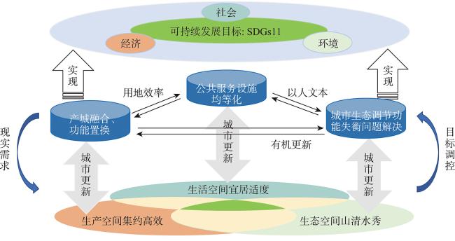
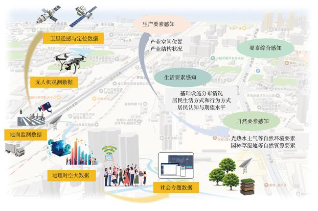
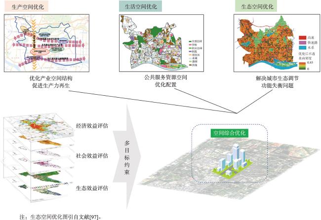
In China, urbanization has entered a later stage characterized by a slowdown in growth rates and a focus on quality enhancement. The urban growth paradigm is transitioning gradually from "incremental development" to "quality improvement of existing urban stock", marking the adoption of a new urbanization mode centered around urban renewal. Urban renewal, as a spatial governance activity within the scope of national territory, aims to continuously enhance city functions, optimize spatial layout, improve environmental quality, and stimulate economic and social vitality. However, challenges of urban renewal, such as the ambiguous definition of urban renewal oriented towards national spatial planning and the lack of a systematic logical framework for geographic information technology tailored for urban renewal, still persist. Therefore, this study reexamines the connotations of urban renewal research from the perspective of the "Production-Living-Ecological" space, expecting to achieve "intensive and efficient production space", "livable and moderate living space", and "beautiful and ecofriendly ecological space". Furthermore, with reference to the three processes of perception, assessment and optimization in "Urban Cognition", the logical architecture of geospatial information technology application for urban renewal is constructed, and based on this framework, the contributions of geographic spatial information technology in data collection, model assessment, and simulation optimization are elucidated. In the production space, geospatial information technology is able to perceive the production elements of urban renewal in real time, rapidly construct the economic benefit assessment index system and spatial assessment model, simulate the geographical process of industrial development, and optimize the spatial pattern of production. In the living space, the application of geospatial information technology helps to integrate the resources of living elements by means of spatial and temporal digitization, comprehensively assess the social benefits and carry out the spatial optimization of the allocation of public service facilities. In the ecological space, geospatial information technology provides an efficient and fast technical method for perceiving the elements of the natural environment and natural resources in a timely manner, constructing an ecological efficiency assessment index system to identify "urban diseases", optimizing the ecological spatial pattern, and exploring coping strategies to solve "urban diseases". Finally, based on the actual needs of urban renewal, the prospects for application of geographic spatial information technology in urban renewal research are discussed. This paper proposes comprehensive perception, comprehensive assessment, comprehensive optimization of urban renewal and construct an urban renewal technology system covering the whole process of "Perception-Assessment-Optimization", so as to improve the city's ability to adapt to the future development of regulation. These efforts will facilitate the modernization of national spatial governance systems and capabilities.

LIN Liangguo , ZHAO Yaolong , KE Entong . Research Status and Prospects of Geospatial Information Technology for Urban Renewal[J]. Journal of Geo-information Science, 2024 , 26(4) : 898 -914 . DOI: 10.12082/dqxxkx.2024.240198
| [1] |
洪银兴, 陈雯. 由城镇化转向新型城市化:中国式现代化征程中的探索[J]. 经济研究, 2023, 58(6):4-18.
[
|
| [2] |
杜海龙. 国际比较视野中我国绿色生态城区评价体系优化研究[D]. 济南: 山东建筑大学, 2020.
[
|
| [3] |
叶锺楠, 吴志强. 城市诊断的概念、思想基础和发展思考[J]. 城市规划, 2022, 46(1):53-59.
[
|
| [4] |
张文忠, 何炬, 谌丽. 面向高质量发展的中国城市体检方法体系探讨[J]. 地理科学, 2021, 41(1):1-12.
[
|
| [5] |
|
| [6] |
|
| [7] |
|
| [8] |
|
| [9] |
王蔚, 李晟, 许昊皓, 等. 基于知识图谱可视化的中西城市更新研究综述[J]. 华中建筑, 2023, 41(7):66-72.
[
|
| [10] |
|
| [11] |
|
| [12] |
|
| [13] |
|
| [14] |
甄峰, 李智轩. 数据驱动的中国城市空间治理框架设想[J]. 经济地理, 2023, 43(5):26-35.
[
|
| [15] |
杨佩卿. 高质量发展视阈下城市更新的内涵逻辑与实践取向[J]. 当代经济科学, 2023, 45(3):59-73.
[
|
| [16] |
中共中央国务院关于建立国土空间规划体系并监督实施的若干意见[N]. 人民日报,2019-05-24(1).
[The Guidance of the Communist Party of China Central Committee and the State Council on Establishing the National Territory Spatial Planning System and Supervising Its Implementation[N]. People's Daily, 2019-05-24(1). ]
|
| [17] |
张令达, 侯全华, 段亚琼. 生态文明背景下三生空间研究:内涵、进展与对策[J]. 生态学报, 2024, 44(1):47-59.
[
|
| [18] |
李泽新, 杨新旗, 王婷. 双重博弈结构下城市更新协作机制及转变趋势研究——以重庆市渝中区为例[J]. 中国名城, 2023, 37(7):24-30.
[
|
| [19] |
陈宁, 周炳中. 城市化进程下的旧城改造和历史文化遗产保护[J]. 经济论坛, 2007(1):39-42.
[
|
| [20] |
|
| [21] |
|
| [22] |
|
| [23] |
|
| [24] |
|
| [25] |
|
| [26] |
郑晓琳, 刘启亮, 刘文凯, 等. 智能卡和出租车轨迹数据中蕴含城市人群活动模式的差异性分析[J]. 地球信息科学学报, 2020, 22(6):1268-1281.
[
|
| [27] |
孙久文, 崔雅琪, 张皓. 黄河流域城市群生态保护与经济发展耦合的时空格局与机制分析[J]. 自然资源学报, 2022, 37(7):1673-1690.
[
|
| [28] |
宋洋, 贺灿飞, 徐阳, 等. 中国城市公园绿地供需时空格局演化及驱动机制[J]. 自然资源学报, 2023, 38(5):1194-1209.
[
|
| [29] |
|
| [30] |
|
| [31] |
刘勇. 城市空间利用优化的目标与方式:“三生” 空间视角[J]. 管理现代化, 2020, 40(4):84-87.
[
|
| [32] |
|
| [33] |
王彬, 杨尧, 赵耀龙. 智慧城市的“灵魂”[J]. 热带地貌, 2020, 41(2):67-76.
[
|
| [34] |
杨尧, 赵耀龙, 王彬. “一联三生” 体系下粤港澳大湾区智慧城市群的构建[J]. 地球信息科学学报, 2022, 24(6):1073-1086.
[
|
| [35] |
|
| [36] |
|
| [37] |
许永成. “空间生产”主导下城市更新中的地方建构研究[D]. 广州: 华南理工大学, 2018.
[
|
| [38] |
|
| [39] |
|
| [40] |
李军, 徐新良, 胡云锋. 基于GIS的我国三次产业结构空间变化研究[J]. 地球信息科学学报, 2010, 12(3):372-379.
[
|
| [41] |
梁育填, 李文涛, 柳林. 基于智能体的企业迁移模拟——以广东省产业转移为例[J]. 经济地理, 2013, 33(7):96-101.
[
|
| [42] |
杨菊萍, 贾生华. 企业迁移的动因识别——基于内容分析法的研究[J]. 地理科学, 2011, 31(1):15-21.
[
|
| [43] |
胡伟, 张玉杰. 中西部承接产业转移的成效——基于地理信息系统的空间分析方法[J]. 当代财经, 2015(2):97-105.
[
|
| [44] |
胡明星, 董卫. GIS技术在历史街区保护规划中的应用研究[J]. 建筑学报, 2004(12):63-65.
[
|
| [45] |
邹兵. 存量发展模式的实践、成效与挑战——深圳城市更新实施的评估及延伸思考[J]. 城市规划, 2017, 41(1):89-94.
[
|
| [46] |
张磊. “新常态”下城市更新治理模式比较与转型路径[J]. 城市发展研究, 2015, 22(12):57-62.
[
|
| [47] |
张明斗, 翁爱华. 东北地区产业结构优化与城市土地集约利用协调性[J]. 自然资源学报, 2022, 37(3):734-752.
[
|
| [48] |
黄磊, 吴传清. 长江经济带污染密集型产业集聚时空特征及其绿色经济效应[J]. 自然资源学报, 2022, 37(2):459-476.
[
|
| [49] |
梁育填, 李文涛, 姜超, 等. 基于多智能体方法的企业迁移空间决策机理的研究框架[J]. 经济地理, 2014, 34(4):112-118.
[
|
| [50] |
|
| [51] |
张杰. 存量时代的城市更新与织补[J]. 建筑学报, 2019(7):1-5.
[
|
| [52] |
柴铁锋, 王元珍, 张毅. 基于空间生产力视角的城市更新路径研究[J]. 建设科技, 2024(5):6-12.
[
|
| [53] |
侯寅峰. 历史街区商业街的保护与更新研究——以西安北院门商业街为例[D]. 西安: 西安建筑科技大学, 2005.
[
|
| [54] |
王世福, 卜拉森, 吴凯晴. 广州城市更新的经验与前瞻[J]. 城乡规划, 2017(6):80-87.
[
|
| [55] |
邬峻. 第四范式:基于机器学习的荷兰智慧城市宜居性预测模型研究[J]. 风景园林, 2020, 27(5):11-29.
[
|
| [56] |
刘佳, 侯佳佳, 亓颖. 基于DEMATEL-ANP模型的中国旅游产业结构优化评价研究[J]. 地理与地理信息科学, 2021, 37(6):102-112.
[
|
| [57] |
周琦, 高长春. 城市创意产业空间动态集聚演化的计算与可视优化方法[J]. 地球信息科学学报, 2020, 22(5):1033-1048.
[
|
| [58] |
张鸿辉, 曾永年, 谭荣, 等. 多智能体区域土地利用优化配置模型及其应用[J]. 地理学报, 2011, 66(7):972-984.
[
|
| [59] |
杜国明, 陈晓翔, 黎夏. 基于微粒群优化算法的空间优化决策[J]. 地理学报, 2006, 61(12):1290-1298.
[
|
| [60] |
杨露, 颉耀文, 宗乐丽, 等. 基于多目标遗传算法和FLUS模型的西北农牧交错带土地利用优化配置[J]. 地球信息科学学报, 2020, 22(3):568-579.
[
|
| [61] |
陆军辉, 梅志雄, 赵书芳, 等. 土地利用配置的混沌蚁群优化算法研究[J]. 地球信息科学学报, 2017, 19(8):1026-1035.
[
|
| [62] |
卢文正. 社会空间理论视角的社区更新:功能导向、 系统适应与治理机制[D]. 杭州: 浙江大学, 2023.
[
|
| [63] |
唐子来. 居住小区服务设施的需求型态:趋势推断和实证检验[J]. 城市规划, 1999(5):31-35,62.
[
|
| [64] |
金珊, 闫安, 周麟, 等. 空间感知视角下的城市公共文化设施空间分布研究——以深圳市为例[J]. 建筑学报, 2015(3):19-23.
[
|
| [65] |
|
| [66] |
|
| [67] |
文琦, 侯凯元, 郑殿元, 等. 成长型资源城市产业转型能力评价与优化路径——以榆林市为例[J]. 地理科学, 2022, 42(4):682-691.
[
|
| [68] |
唐亚林, 钱坤. “找回居民”:专家介入与城市基层治理模式创新的内生动力再造[J]. 学术月刊, 2020, 52(1):84-96.
[
|
| [69] |
万欣, 丁欣宇, 张天天, 等. 考虑基础设施中断的暴雨灾害社会影响研究——基于公众视角的情感与行为演化分析[J]. 自然资源学报, 2023, 38(11):2919-2932.
[
|
| [70] |
宋佳莹, 郭璟. 基本公共服务均等化水平测度:可及性与受益性视角[J]. 统计与决策, 2024, 40(4):91-95.
[
|
| [71] |
吴莞姝, 党煜婷, 赵凯. 基于多维感知的城市活力空间特征研究[J]. 地球信息科学学报, 2022, 24(10):1867-1882.
[
|
| [72] |
魏伟, 石培基, 冯海春, 等. 干旱内陆河流域人居环境适宜性评价——以石羊河流域为例[J]. 自然资源学报, 2012, 27(11):1940-1950.
[
|
| [73] |
|
| [74] |
陶卓霖, 戴特奇, 宋长青. 空间公平导向的城市医疗设施优化配置模型研究[J]. 地理学报, 2023, 78(2):474-489.
[
|
| [75] |
栾兆亮, 涂伟, 沈少青, 等. 基于空间启发式的城市地铁线路选址优化方法[J]. 地理与地理信息科学, 2019, 35(4):64-69,90.
[
|
| [76] |
冯琰玮, 甄江红. 内蒙古自治区人居环境综合适宜性评价及空间优化[J]. 地球信息科学学报, 2022, 24(6):1204-1217.
[
|
| [77] |
冉江, 黄荷筠, 邹镕坤. 基于多源大数据的长三角城市群AQI遥感估算[J]. 复旦学报(自然科学版), 2023, 62(6):786-795.
[
|
| [78] |
李朋飞, 李豆, 胡晋飞, 等. 机载LiDAR监测黄土高原土壤侵蚀的能力评估[J]. 测绘学报, 2023, 52(8):1342-1354.
[
|
| [79] |
赵宇博, 王雪霁, 刘骁, 等. 精细光谱探测与计量分析技术在长江干流水质水环境监测中的应用[J]. 地理学报, 2024, 79(1):45-57.
[
|
| [80] |
郑渊茂, 王业宁, 周强, 等. 基于景感生态学的生态环境物联网框架构建[J]. 生态学报, 2020, 40(22):8093-8102.
[
|
| [81] |
周成虎. 自然资源要素综合观测体系专辑序言[J]. 资源科学, 2020, 42(10):1837-1838.
[
|
| [82] |
张继贤, 李海涛, 顾海燕, 等. 人机协同的自然资源要素智能提取方法[J]. 测绘学报, 2021, 50(8):1023-1032.
[
|
| [83] |
沈佳洁, 曹侃, 祁信舒. 自然资源要素遥感智能解译样本分类体系研究[J]. 地理空间信息, 2023, 21(4):103-106.
[
|
| [84] |
赵春黎, 严岩, 陆咏晴, 等. 基于暴露度—恢复力—敏感度的城市适应气候变化能力评估与特征分析[J]. 生态学报, 2018, 38(9):3238-3247.
[
|
| [85] |
杨浩, 王子羿, 王婧, 等. 京津冀城市群土地利用变化对热环境的影响研究[J]. 自然资源学报, 2018, 33(11):1912-1925.
[
|
| [86] |
高雅婵, 梁勤欧, 于红梅. 基于需求场理论的浙江城市水资源利用强度时空格局及演变[J]. 资源科学, 2018, 40(2):335-346.
[
|
| [87] |
|
| [88] |
何改丽, 李加林, 刘永超, 等. 1985—2015年美国坦帕湾流域土地开发利用强度时空变化分析[J]. 自然资源学报, 2019, 34(1):66-79.
[
|
| [89] |
吴大放, 胡悦, 刘艳艳, 等. 城市开发强度与资源环境承载力协调分析——以珠三角为例[J]. 自然资源学报, 2020, 35(1):82-94.
[
|
| [90] |
黄秋森, 赵岩, 许新宜, 等. 基于弹簧模型的资源环境承载力评价及应用——以内蒙古自治区陈巴尔虎旗为例[J]. 自然资源学报, 2018, 33(1):173-184.
[
|
| [91] |
孟菲, 赵海霞, 牛铭杰, 等. 南京市环境承载力评价及其成因分析[J]. 中国环境科学, 2019, 39(9):4007-4016.
[
|
| [92] |
|
| [93] |
|
| [94] |
|
| [95] |
欧定华, 夏建国. 基于粒子群算法的大城市近郊区景观格局优化研究——以成都市龙泉驿区为例[J]. 地理研究, 2017, 36(3):553-572.
[
|
| [96] |
李彬烨, 赵耀龙, 付迎春. 广州城市暴雨内涝时空演变及建设用地扩张的影响[J]. 地球信息科学学报, 2015, 17(4):445-450.
[
|
| [97] |
梁志承, 赵耀龙, 付迎春. 耦合蚁群算法和SCS-CN水文模型的城市不透水面空间格局优化[J]. 地球信息科学学报, 2017, 19(10):1315-1326.
[
|
| [98] |
|
| [99] |
|
/
| 〈 |
|
〉 |


