
Journal of Geo-information Science >
Mapping the Landslide Susceptibility Considering Future Land Use Dynamics Scenario
Received date: 2024-01-05
Revised date: 2024-02-10
Online published: 2024-05-24
Supported by
National Natural Science Foundation of China(4187752)
National Natural Science Foundation of China(41601563)
National Key Research and Development Program of China(2023YFC3007201)
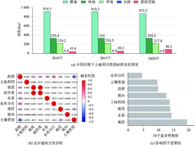
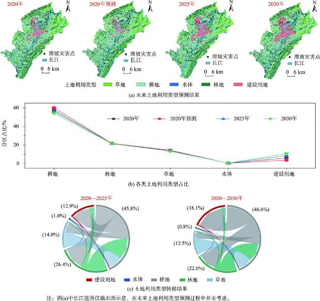
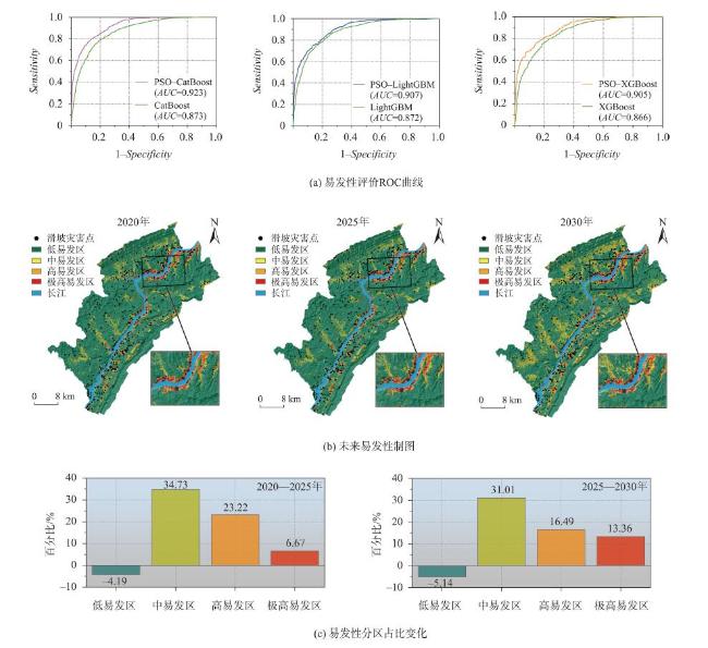
The urbanization in mountainous areas will cause land use changes, thereby potentially altering the landslide susceptibility. However, there is a lack of research on landslide susceptibility under future land use dynamics in landslide hazard management at present. In this study, taking the towns along the Yangtze River in Wanzhou District, Chongqing City as an example, we first used the Patch-generating Land Use Simulation (PLUS) model to predict the dynamic factors of land use in 2025 and 2030. Then, combined with the static factors collected and landslide data in the study area, we constructed a database for susceptibility assessment. The Particle Swarm Optimization (PSO) algorithm was used to adjust the hyperparameters of the ensemble learning models based on the GBDT (Gradient Boosting Decision Tree) framework, including XGBoost, LightGBM, and CatBoost, and conduct dynamic susceptibility modeling. Finally, we mapped the landslide susceptibility under scenarios of future land use dynamics based on the optimal evaluation model. The results show that: (1) the land use change results based on the PLUS model can provide accurate basic data for predicting future landslide-prone areas; (2) by comparing the AUC results before and after the involvement of the PSO algorithm in the modeling, we found that the PSO-CatBoost model was able to better fit the nonlinear relationship between the landslide inventory and the triggering factor in the study area, and achieved an optimal modeling accuracy; (3) our research framework that integrates future land use dynamics and landslide susceptibility suggested that future development of building lands in townships along the Yangtze River will increase landslide susceptibility. The research approach proposed in this paper is of great practical significance for building a resilient and effective disaster prevention and reduction system in mountainous urban areas and can provide scientific guidance for the future planning of mountainous urban areas.
JIN Bijing , ZENG Taorui , GUI Lei , YIN Kunlong , ZHU Yuhang , LIU Yang . Mapping the Landslide Susceptibility Considering Future Land Use Dynamics Scenario[J]. Journal of Geo-information Science, 2024 , 26(6) : 1486 -1499 . DOI: 10.12082/dqxxkx.2024.240009
表1 土地利用转换情景矩阵(2020—2030年)Tab. 1 Land use conversion scenario matrix (2020-2030) |
| 耕地 | 林地 | 草地 | 水系 | 建设用地 | |
|---|---|---|---|---|---|
| 耕地 | 1 | 1 | 1 | 0 | 0 |
| 林地 | 1 | 1 | 1 | 0 | 1 |
| 草地 | 1 | 1 | 1 | 0 | 1 |
| 水系 | 0 | 0 | 0 | 1 | 0 |
| 建设用地 | 1 | 1 | 1 | 0 | 1 |
表2 PSO优化算法控制参数优化情况Tab. 2 PSO optimization algorithm control parameter optimization table |
| 模型 | 超参数 | 参数空间 | PSO控制参数 |
|---|---|---|---|
| CatBoost | 基学习器 | gbdt | 种群大小:50 最大迭代次数:200 惯性权重:0.9 全局系数:2 局部系数:2 |
| 学习率 | 0.1 | ||
| 树的最大深度 | 10 | ||
| 过拟合检测阈值 | 0 | ||
| 达成优化后继续迭代次数 | 20 | ||
| LightGBM | 基学习器数量 | 100 | 种群大小:50 最大迭代次数:200 惯性权重:0.9 全局系数:2 局部系数:2 |
| 基学习器 | gbdt | ||
| 学习率 | 0.1 | ||
| 样本征采率 | 0.8 | ||
| 树特征采样率 | 0.8 | ||
| 叶子节点中样本的最小权重 | 0.75 | ||
| 树最大深度 | 10 | ||
| 叶子节点最小样本数 | 10 | ||
| XGBoost | 基学习器数量 | 100 | 种群大小:50 最大迭代次数:200 惯性权重:0.9 全局系数:2 局部系数:2 |
| 基学习器 | gbtree | ||
| 学习率 | 0.1 | ||
| 树最大深度 | 10 | ||
| 样本征采率 | 0.8 | ||
| 树特征采样率 | 0.8 | ||
| 叶子节点中样本的最小权重 | 0.75 |
表3 土地利用模拟数据来源Tab. 3 Land use simulation data source |
| 数据类型 | 数据名称 | 分辨率 | 数据来源 |
|---|---|---|---|
| 土地利用数据 | 2010年土地利用数据 | 30 m | 中国科学院资源环境数据中心(https://www.resdc.cn) |
| 2015年土地利用数据 | 30 m | ||
| 2020年土地利用数据 | 30 m | ||
| 社会经济数据 | 2020年人口 | 1 km | OpenStreetMap (www.openstreetmap.org) |
| 2020年GDP | 1 km | ||
| 2020年到一级道路距离 | 30 m | ||
| 2020年到二级道路距离 | 30 m | ||
| 2020年到三级道路距离 | 30 m | ||
| 2020年到政府距离 | 30 m | ||
| 气候与环境数据 | 2020年到水域距离 | 30 m | 中国科学院资源环境数据中心(https://www.resdc.cn) |
| 土壤类型 | 30 m | ||
| 2010—2020年平均降水 | 1 km | ||
| 2010—2020年平均温度 | 1 km | ||
| 高程 | 12.5 m | ASF Data Search (https://search.asf.alaska.edu) | |
| 坡度 | 12.5 m |
| [1] |
|
| [2] |
|
| [3] |
郭子正, 殷坤龙, 付圣, 等. 基于GIS与WOE-BP模型的滑坡易发性评价[J]. 地球科学, 2019, 44(12):4299-4312.
[
|
| [4] |
周超, 甘露露, 王悦, 等. 综合非滑坡样本选取指数与异质集成机器学习的区域滑坡易发性建模[J]. 地球信息科学学报, 2023, 25(8):1570-1585.
[
|
| [5] |
刘纪远. 国家资源环境遥感宏观调查与动态监测研究[J]. 遥感学报, 1997, 1(3):225-230.
[
|
| [6] |
|
| [7] |
|
| [8] |
|
| [9] |
|
| [10] |
|
| [11] |
|
| [12] |
|
| [13] |
徐新良, 刘纪远, 张树文. 中国多时期土地利用遥感监测数据集(CNLUCC [Z]. 资源环境科学数据注册与出版系统(http://www.resdc.cn/DOI)[Z]. 2018
[
|
| [14] |
牛统莉, 熊立华, 陈杰, 等. 基于PLUS模型的长江流域土地利用变化模拟与多情景预测[J/OL]. 武汉大学学报(工学版), 2023:1-16.(2023-03-14).
[
|
| [15] |
|
| [16] |
林素丽, 王枫. 基于PLUS模型并顾及交通规划的广州市土地利用情景模拟与分析[J]. 农业资源与环境学报, 2023, 40(3):557-569.
[
|
| [17] |
黄发明, 陈佳武, 唐志鹏, 等. 不同空间分辨率和训练测试集比例下的滑坡易发性预测不确定性[J]. 岩石力学与工程学报, 2021, 40(6):1155-1169.
[
|
| [18] |
黄发明, 殷坤龙, 蒋水华, 等. 基于聚类分析和支持向量机的滑坡易发性评价[J]. 岩石力学与工程学报, 2018, 37(1):156-167.
[
|
| [19] |
周超, 殷坤龙, 曹颖, 等. 基于集成学习与径向基神经网络耦合模型的三峡库区滑坡易发性评价[J]. 地球科学, 2020, 45(6):1865-1876.
[
|
| [20] |
杨永刚, 殷坤龙, 赵海燕, 等. 基于C5.0决策树-快速聚类模型的万州区库岸段乡镇滑坡易发性区划[J]. 地质科技情报, 2019, 38(6):189-197.
[
|
| [21] |
黄发明, 石雨, 欧阳慰平, 等. 基于证据权和卡方自动交互检测决策树的滑坡易发性预测[J]. 土木与环境工程学报(中英文), 2022, 44(5):16-28.
[
|
| [22] |
林炫歆, 肖桂荣, 周侯伯. 顾及土地利用动态变化的滑坡易发性评估方法[J]. 地球信息科学学报, 2023, 25(5):953-966.
[
|
| [23] |
|
| [24] |
|
| [25] |
|
| [26] |
|
| [27] |
张俊, 殷坤龙, 王佳佳, 等. 基于时间序列与PSO-SVR耦合模型的白水河滑坡位移预测研究[J]. 岩石力学与工程学报, 2015, 34(2):382-391.
[
|
| [28] |
姜宇航, 王伟, 邹丽芳, 等. 基于粒子群-变分模态分解、非线性自回归神经网络与门控循环单元的滑坡位移动态预测模型研究[J]. 岩土力学, 2022, 43(S1):601-612.
[
|
| [29] |
|
| [30] |
|
| [31] |
|
| [32] |
|
| [33] |
|
| [34] |
|
| [35] |
|
| [36] |
|
| [37] |
郭子正, 殷坤龙, 黄发明, 等. 基于滑坡分类和加权频率比模型的滑坡易发性评价[J]. 岩石力学与工程学报, 2019, 38(2):287-300.
[
|
| [38] |
|
/
| 〈 |
|
〉 |
