
Journal of Geo-information Science >
Coupling Mixed Pixel Decomposition and Mixed-cell Simulation for Land Cover Change Deduction
Received date: 2023-09-22
Revised date: 2024-04-14
Online published: 2024-06-25
Supported by
International Research Center of Big Data for Sustainable Development Goals(CBAS2022GSP05)
National Natural Science Foundation of China(42271437)
National Natural Science Foundation of China(42171466)
Scientific Research Program of the Department of Natural Resources of Hubei Province(ZRZY2022KJ12)
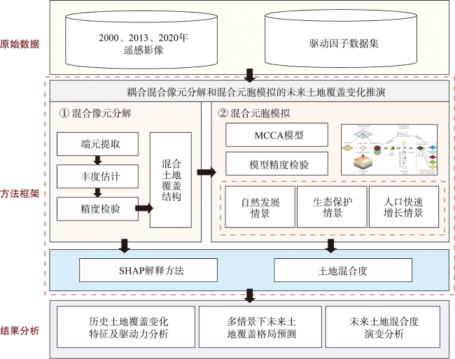
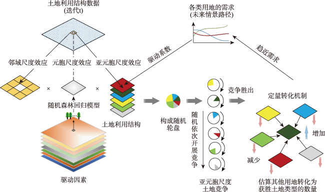
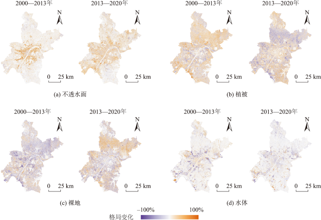
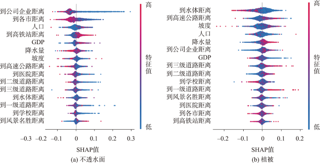
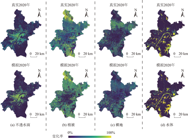
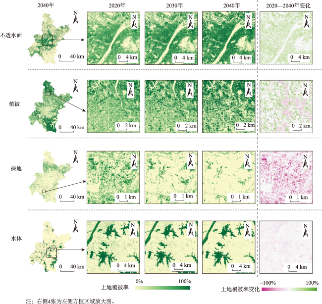
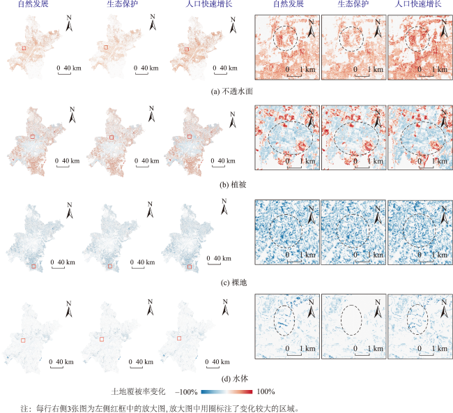
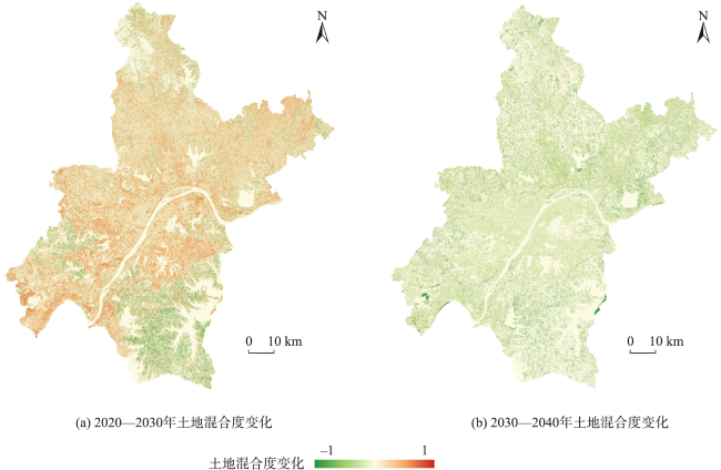
Cellular Automata (CA) provides an important tool for land use/land cover change simulation. However, previous CA models based on pure cells ignore the mixed land cover structure within cells, making it difficult to simulate the continuous evolution of mixed land systems during rapid urbanization. The Mixed-Cell Cellular Automata (MCCA) can address this issue, but its widespread application is hindered by the difficulty in obtaining fine-scale mixed structure data. To solve these problems, this study proposes a simulation analysis framework that couples the mixed pixel decomposition method with the MCCA model. This framework uses the mixed pixel decomposition algorithm to directly obtain the sub-pixel scale mixed structure data required by the MCCA model from Landsat images. The SHAP method is utilized to explore the driving forces of sub-pixel scale land cover change. To verify the proposed framework, we conducts an experiment in Wuhan city. Results show that: 1) The decomposition accuracy of the land cover data is above 0.8, and the mcFoM index of the simulation results is 0.38, indicating that this coupled model has high accuracy in characterizing the spatial pattern of mixed land structures and simulating future changes; 2) The proposed coupling model can effectively simulate the fine-scale dynamic changes of land cover proportions and discover relevant patterns of regional land use changes. For example, future land cover structure changes will mainly concentrate in built-up areas, and land mixture will experience a process of increasing first and then decreasing. Socio-economic factors such as proximity to companies, the municipal government, and high population and GDP are important driving factors for the expansion of impervious surfaces, and impervious surfaces in urban centers relatively far from high-speed railway stations grow more rapidly; 3) The future land cover change trends simulated by the proposed model are consistent with the future planning layout of Wuhan. The comparison between multiple scenarios demonstrates the MCCA model’s ability to accurately capture the subtle differences in land cover proportion between pixels. This method couples the mixed pixel decomposition method from the field of remote sensing with the mixed Cellular Automata (CA) model from the field of GIS, solving the problem of lacking fine-scale data sources for simulating mixed land cover structures. It simulates future changes in mixed land cover structures at the sub-pixel scale, which can enrich existing research on mixed land structures and provide a certain theoretical basis for urban development decisions. Additionally, it opens up new avenues for the application of CA models in other areas.

CAO Wei , XIAO Yao , LIANG Xun , GUAN Qingfeng . Coupling Mixed Pixel Decomposition and Mixed-cell Simulation for Land Cover Change Deduction[J]. Journal of Geo-information Science, 2024 , 26(7) : 1611 -1628 . DOI: 10.12082/dqxxkx.2024.230571
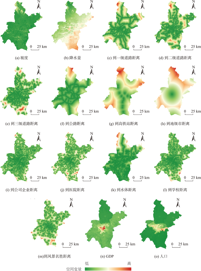
表1 土地覆盖变化驱动因子信息Tab. 1 Information of driving factors for land cover change |
| 类别 | 数据 | 年份 | 原始分辨率 | 数据来源 |
|---|---|---|---|---|
| 气候环境 | 坡度 | 2016 | 30 m | NASA SRTM v3.0 |
| 高程 | 2016 | 30 m | NASA SRTM v3.0 | |
| 年降水量 | 2010 | 30 arc-sec | WorldClim v2.0 (http://www.worldclim.org/) | |
| 年平均温度 | 2013 | 30 arc-sec | WorldClim v2.0 (http://www.worldclim.org/) | |
| 社会经济 | GDP | 2015 | 1 000 m | 中国科学院资源环境科学与数据中心 (http://www.resdc.cn/Default.aspx) |
| 人口 | 2015 | 1 000 m | 中国科学院资源环境科学与数据中心 (http://www.resdc.cn/Default.aspx) | |
| 到医院的距离 | 2020 | 30 m | 百度开放平台 (https://lbsyun.baidu.com/) | |
| 到风景名胜距离 | 2020 | 30 m | 百度开放平台 (https://lbsyun.baidu.com/) | |
| 到公司企业距离 | 2020 | 30 m | 百度开放平台 (https://lbsyun.baidu.com/) | |
| 到学校的距离 | 2020 | 30 m | 百度开放平台 (https://lbsyun.baidu.com/) | |
| 到饭店的距离 | 2020 | 30 m | 百度开放平台 (https://lbsyun.baidu.com/) | |
| 区位条件 | 到县城的距离 | 2020 | 30 m | 百度开放平台 (https://lbsyun.baidu.com/) |
| 到省会的距离 | 2020 | 30 m | 百度开放平台 (https://lbsyun.baidu.com/) | |
| 到水体的距离 | 2020 | 30 m | 地理空间数据云 (https://www.gscloud.cn/) | |
| 到各地级市的距离 | 2020 | 30 m | 百度开放平台 (https://lbsyun.baidu.com/) | |
| 到高铁站的距离 | 2020 | 30 m | 百度开放平台 (https://lbsyun.baidu.com/) | |
| 交通 | 到各级道路(高速公路、主干道、铁路、 一级道路、二级道路、三级道路)的距离 | 2015 | 30 m | OpenStreetMap (https://www.openstreetmap.org/) |
表2 不同情景中各土地覆盖类型的需求Tab. 2 Demand for each land cover type in different scenarios (%) |
| 情景 | 不透水面 | 植被 | 裸地 | 水体 |
|---|---|---|---|---|
| 自然发展 | 29.37 | 48.49 | 10.38 | 11.76 |
| 生态保护 | 26.74 | 49.44 | 12.06 | 11.76 |
| 人口快速增长 | 31.83 | 47.23 | 9.18 | 11.76 |
表4 MCCA模型的参数和精度Tab. 4 Parameters and simulation accuracy of the MCCA model |
| 模型 | 参数 | 不透水面 | 植被 | 裸地 | 水体 | |
|---|---|---|---|---|---|---|
| 随机森林回归 | 参数 | 回归树数量 | 50 | |||
| 采样率 | 0.1 | |||||
| CA模型 | 参数 | 邻域 | 3×3 | |||
| 步长 | 1 | 1 | 1 | 1 | ||
| 精度 | 总体精度 | 0.71 | ||||
| mcFoM | 0.38 (PA=0.43, UA=0.53) | |||||
| [1] |
李少英, 刘小平, 黎夏, 等. 土地利用变化模拟模型及应用研究进展[J]. 遥感学报, 2017, 21(3):329-340.
[
|
| [2] |
|
| [3] |
|
| [4] |
|
| [5] |
|
| [6] |
|
| [7] |
黎夏, 叶嘉安, 刘小平. 地理模拟系统在城市规划中的应用[J]. 城市规划, 2006, 30(6):69-74.
[
|
| [8] |
王旭东, 姚尧, 任书良, 等. 耦合FLUS和Markov的快速发展城市土地利用空间格局模拟方法[J]. 地球信息科学学报, 2022, 24(1):100-113.
[
|
| [9] |
赵轩, 彭建东, 樊智宇, 等. “双评价” 视角下基于FLUS模型的武汉大都市区土地利用模拟和城镇开发边界划定研究[J]. 地球信息科学学报, 2020, 22(11):2212-2226.
[
|
| [10] |
|
| [11] |
|
| [12] |
|
| [13] |
|
| [14] |
|
| [15] |
|
| [16] |
|
| [17] |
朱晓青. 混合功能人居:“产住共同体” 聚落的演进、机理与建构[M]. 北京: 中国建筑工业出版社, 2014.
[
|
| [18] |
|
| [19] |
|
| [20] |
|
| [21] |
|
| [22] |
|
| [23] |
|
| [24] |
|
| [25] |
郑红玉, 吴次芳, 沈孝强. 土地混合利用研究评述及框架体系构建[J]. 经济地理, 2018, 38(3):157-164.
[
|
| [26] |
|
| [27] |
吕青宙, 林伊琳, 赵俊三, 等. 昆明市土地混合度预测与土地混合利用演变相关性分析[J]. 兰州大学学报(自然科学版), 2022, 58(4):548-559.
[
|
| [28] |
师青霞, 张亚平, 徐斌. 基于MCCA多情景模拟的浙北地区景观稳定性时空变化[J]. 生态学杂志, 2023, 42(2):445-453.
[
|
| [29] |
李卓, 韩文超, 胡起源, 等. 融合光谱混合分解与面向对象的土地利用/覆被分类[J]. 农业工程学报, 2021, 37(17):225-233.
[
|
| [30] |
|
| [31] |
朱爽, 张锦水, 李长青, 等. 土地覆盖遥感制图方法研究现状与展望[J]. 测绘通报, 2019(11):8-11.
[
|
| [32] |
常梦迪, 王新军, 闫立男, 等. 天山北坡中段山区植被覆盖管理措施因子的时空格局动态变化[J]. 农业资源与环境学报, 2022, 39(4):836-846.
[
|
| [33] |
朱玲, 李明, 秦凯, 等. 矿物高光谱解混进展研究综述[J]. 遥感信息, 2020, 35(3):15-23.
[
|
| [34] |
|
| [35] |
|
| [36] |
|
| [37] |
|
| [38] |
|
| [39] |
|
| [40] |
|
| [41] |
|
| [42] |
|
| [43] |
|
| [44] |
|
| [45] |
李俊芳, 姚敏峰, 季峰, 等. 土地利用混合度对轨道交通车站客流的影响[J]. 同济大学学报(自然科学版), 2016, 44(9):1415-1423.
[
|
| [46] |
|
| [47] |
俞钦平, 吴振华, 王亚蓓. 一种耦合进化算法与FLUS模型的土地利用变化模拟模型[J]. 地球信息科学学报, 2023, 25(3):510-528.
[
|
| [48] |
|
| [49] |
|
/
| 〈 |
|
〉 |
