
Journal of Geo-information Science >
Two-Stage Multi-Source Precipitation Data Merging Method Combining Bias Correction and Dynamic Constrained Linear Regression Model
Received date: 2024-08-02
Revised date: 2024-09-29
Online published: 2024-11-07
Supported by
National Key Research and Development Program of China(2016YFC0401004)
Independent Innovation Foundation of HUST—Exploration Fund(2016JCTD115)
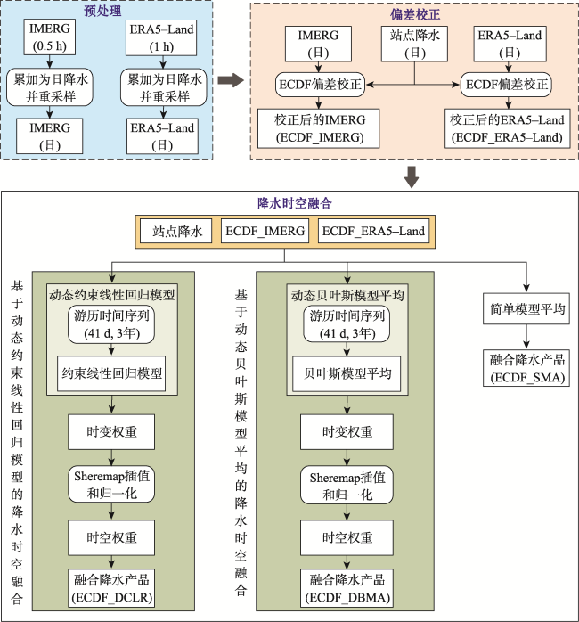
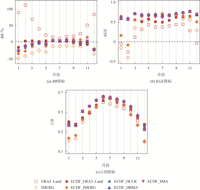
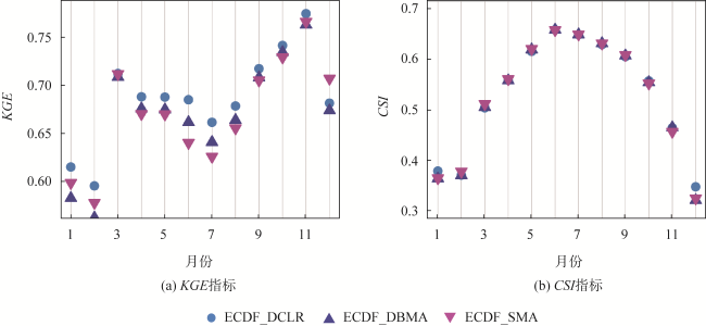
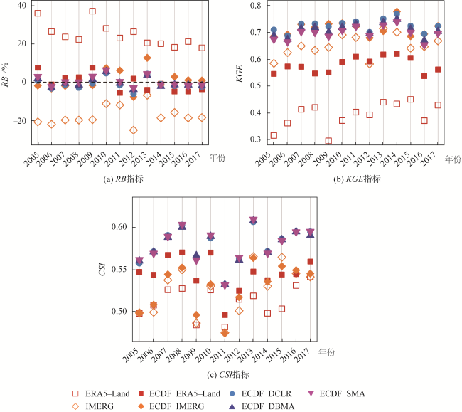
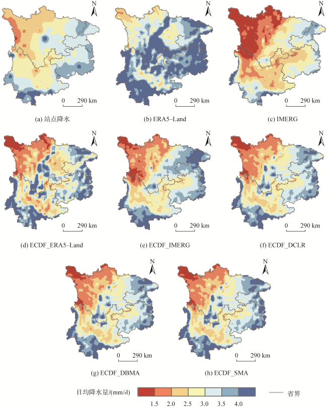
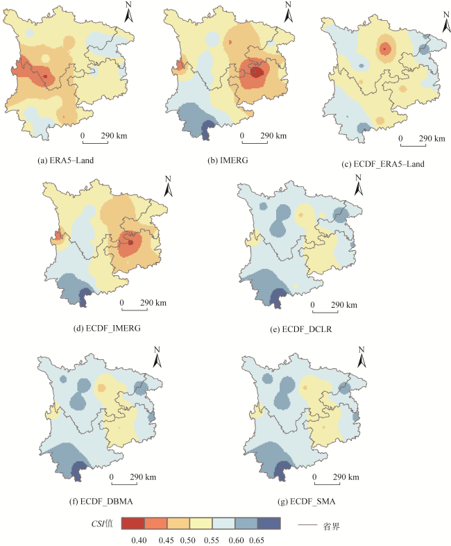
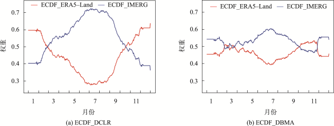
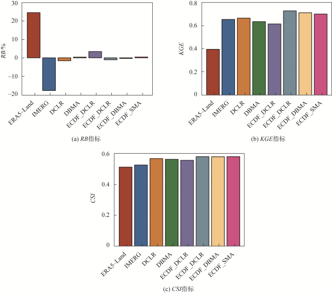
Precipitation merging technology integrates muliple precipitation datasets to obtain more accurate and reliable precipitation information. However, these data sources have inherent systematic biases and precipitation exhibits spatiotemporal heterogeneity. To address these issues, this paper proposed a two-stage precipitation merging method combining bias correction and precipitation spatiotemporal fusion. In the first stage, the biases in precipitation products are corrected by the Experience Cumulative Distribution Function matching method (ECDF). In the second stage, a Dynamic Constrained Linear Regression model (DCLR) is used to determine spatiotemporal weights, followed by weighted averaging of the the bias-corrected precipitation products. The proposed method is termed as ECDF_DCLR. In addition, the Dynamic Bayesian Model Average (DBMA) and Simple Model Average (SMA) are used in the second stage along with ECDF, forming the contrasting methods ECDF_DBMA and ECDF_SMA, to verify the effectiveness of ECDF_DCLR. ECDF_DCLR, ECDF_DBMA and ECDF_SMA were applied to integrate satellite precipitation product IMERG and reanalysis precipitation product ERA5-Land in Southwest China from 2005 to 2017, using precipitation data from ground meteorological stations as the reference for evaluation. Results show that: (1) ECDF can effectively reduce the systematic bias in IMERG and ERA5-Land while improving their accuracy, with the absolute values of RB decreasing by 95.5% and 99.6%, and KGE increasing by 12.7% and 41.5%, respectively. ECDF also enhances the precipitation event detection capability of ERA5-Land (The CSI of ERA5-Land increases by 7.8%), but has a minimal impact on IMERG (The CSI of IMERG remains unchanged at 0.53). Additionally, it is necessary to perform bias correction before fusion, as the KGEs and CSIs of precipitation products generated by combining bias correction and spatiotemporal fusion are, on average, 11.5% and 3.1% higher than those generated by spatiotemporal fusion alone, respectively. (2) DCLR, SMA, and DBMA all effectively integrate precipitation products. Among the three methods, DCLR has the best accuracy of precipitation fusion. There is little difference between them in improving the detection ability of precipitation events. At different time scales, spatial scale, and different altitude grades, the KGEs and CSIs of three fusion precipitation products are mostly greater than or close to the KGE and CSI of the best data source. Among fusion precipitation products, the precipitation product fused by DCLR has the highest KGE. While the differences in CSIs between fusion precipitation products do no exceed 0.01. Compared to Geographically Weighted Regression and Kriging with External Drift, the most metrics of ECDF_DCLR perform better, with KGE and CSI at least 4.3% and 1.8% higher than the former, respectively. In short, the precipitation merging method combined with ECDF and DCLR can provide more accurate precipitation data for Southwest China and offer new insights into multi-source precipitation data merging research.

XIE Wenhao , YI Shanzhen , LENG Chuang . Two-Stage Multi-Source Precipitation Data Merging Method Combining Bias Correction and Dynamic Constrained Linear Regression Model[J]. Journal of Geo-information Science, 2024 , 26(11) : 2506 -2528 . DOI: 10.12082/dqxxkx.2024.240432
表1 西南地区2005—2017年各个降水产品与验证站点数据的评价指标Tab. 1 Evaluation indicators of precipitation products against validation station observations in Southwest China from 2005 to 2017 |
| 产品 | RMSE/(mm/d) | RB/% | CC | KGE | POD | FAR | CSI |
|---|---|---|---|---|---|---|---|
| ERA5-Land | 7.67 | 24.4 | 0.60 | 0.41 | 0.92 | 0.47 | 0.51 |
| IMERG | 6.80 | -17.6 | 0.71 | 0.63 | 0.66 | 0.28 | 0.53 |
| ECDF_ERA5-Land | 8.37 | 0.1 | 0.59 | 0.58 | 0.72 | 0.31 | 0.55 |
| ECDF_IMERG | 6.86 | 0.8 | 0.72 | 0.71 | 0.71 | 0.32 | 0.53 |
| ECDF_DCLR | 6.06 | -1.1 | 0.77 | 0.73 | 0.80 | 0.32 | 0.58 |
| ECDF_DBMA | 6.17 | -0.3 | 0.76 | 0.71 | 0.80 | 0.32 | 0.58 |
| ECDF_SMA | 6.29 | 0.4 | 0.75 | 0.70 | 0.80 | 0.33 | 0.58 |
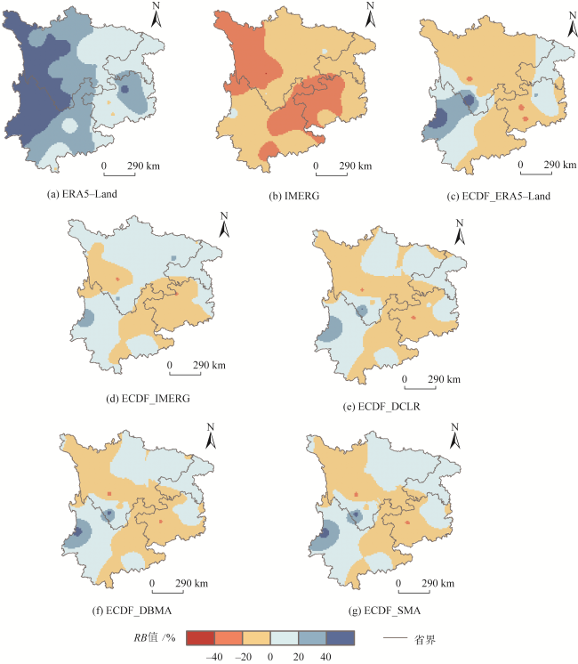
图7 西南地区各个降水产品RB空间分布Fig. 7 Spatial distribution of RB for precipitation products in Southwest China |
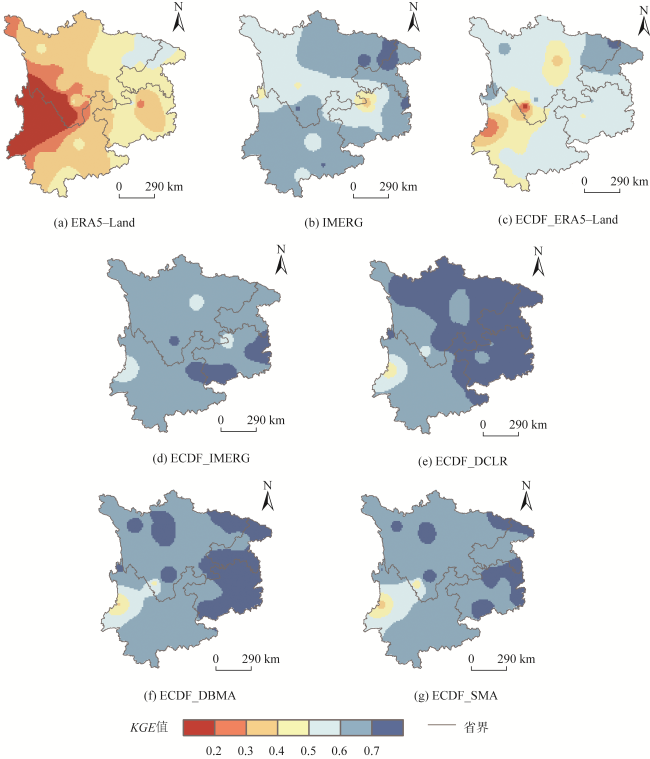
图8 西南地区各个降水产品KGE空间分布Fig. 8 Spatial distribution of KGE for precipitation products in Southwest China |
表2 不同海拔处各个降水产品与验证站点数据的RB、KGE和CSITab. 2 RBs, KGEs and CSIs of precipitation products against validation station observations in different altitudes |
| RB/% | ||||
|---|---|---|---|---|
| 产品 | <1 000 m | 1 000~15 00 m | 1 500~2 500 m | >2 500 m |
| ERA5-Land | 20.3 | 7.7 | 33.5 | 60.6 |
| IMERG | -11.1 | -23.5 | -19.0 | -26.7 |
| ECDF_ERA5-Land | 4.3 | -9.7 | -0.1 | 7.6 |
| ECDF_IMERG | 7.2 | -8.4 | 1.0 | -3.7 |
| ECDF_DCLR | 3.2 | -9.8 | 0 | 0.2 |
| ECDF_DBMA | 4.5 | -9.3 | 0 | 1.1 |
| ECDF_SMA | 5.6 | -9.1 | 0.4 | 1.9 |
| KGE | ||||
| 产品 | <1 000 m | 1 000~1 500 m | 1 500~2 500 m | >2 500 m |
| ERA5-Land | 0.44 | 0.44 | 0.32 | 0.19 |
| IMERG | 0.69 | 0.62 | 0.63 | 0.56 |
| ECDF_ERA5-Land | 0.60 | 0.54 | 0.56 | 0.59 |
| ECDF_IMERG | 0.70 | 0.72 | 0.72 | 0.71 |
| ECDF_DCLR | 0.72 | 0.72 | 0.72 | 0.75 |
| ECDF_DBMA | 0.71 | 0.70 | 0.70 | 0.73 |
| ECDF_SMA | 0.69 | 0.69 | 0.69 | 0.72 |
| CSI | ||||
| 产品 | <1 000 m | 1 000~1 500 m | 1 500~2 500 m | >2 500 m |
| ERA5-Land | 0.54 | 0.53 | 0.49 | 0.47 |
| IMERG | 0.51 | 0.52 | 0.56 | 0.52 |
| ECDF_ERA5-Land | 0.55 | 0.54 | 0.55 | 0.55 |
| ECDF_IMERG | 0.51 | 0.53 | 0.57 | 0.53 |
| ECDF_DCLR | 0.57 | 0.57 | 0.59 | 0.58 |
| ECDF_DBMA | 0.57 | 0.57 | 0.60 | 0.58 |
| ECDF_SMA | 0.57 | 0.57 | 0.60 | 0.58 |
表3 ECDF_DCLR、GWR和KED融合方法的评价指标Tab. 3 Evaluation indicators of ECDF_DCLR,GWR and KED merging methods |
| 产品 | RMSE/(mm/d) | RB/% | CC | KGE | POD | FAR | CSI |
|---|---|---|---|---|---|---|---|
| ERA5-Land | 7.67 | 24.4 | 0.60 | 0.41 | 0.92 | 0.47 | 0.51 |
| IMERG | 6.80 | -17.6 | 0.71 | 0.63 | 0.66 | 0.28 | 0.53 |
| ECDF_DCLR | 6.06 | -1.1 | 0.77 | 0.73 | 0.80 | 0.32 | 0.58 |
| GWR | 6.12 | 3.2 | 0.76 | 0.70 | 0.88 | 0.38 | 0.57 |
| KED | 6.12 | 2.3 | 0.76 | 0.69 | 0.88 | 0.40 | 0.56 |
| [1] |
|
| [2] |
|
| [3] |
|
| [4] |
何青鑫, 陈传法, 王宇辉, 等. 多源遥感日降水数据融合方法:顾及空间自相关的随机森林模型[J]. 地球信息科学学报, 2024, 26(6):1517-1530.
[
|
| [5] |
李伶杰, 王银堂, 唐国强, 等. 考虑有雨无雨辨识的多源降水融合方法[J]. 水科学进展, 2022, 33(5):780-793.
[
|
| [6] |
|
| [7] |
|
| [8] |
|
| [9] |
|
| [10] |
|
| [11] |
唐国强, 万玮, 曾子悦, 等. 全球降水测量(GPM)计划及其最新进展综述[J]. 遥感技术与应用, 2015, 30(4):607-615.
[
|
| [12] |
|
| [13] |
|
| [14] |
|
| [15] |
|
| [16] |
|
| [17] |
|
| [18] |
|
| [19] |
|
| [20] |
|
| [21] |
|
| [22] |
|
| [23] |
|
| [24] |
|
| [25] |
|
| [26] |
|
| [27] |
|
| [28] |
|
| [29] |
周媛媛, 杨晓辉, 肖天贵. 基于宽度学习系统的云南省多源降水数据融合模型研究[J/OL]. 高原气象. https://link.cnki.net/urlid/62.1061.p.20231130.1308.008.
[
|
| [30] |
杜晓婉, 陈曦, 郑宏伟, 等. 一种降水降尺度模型:地形约束下的条件生成对抗网络[J]. 地球信息科学学报, 2023, 25(8):1586-1600.
[
|
| [31] |
|
| [32] |
|
| [33] |
|
| [34] |
|
| [35] |
|
| [36] |
|
| [37] |
|
| [38] |
|
| [39] |
|
| [40] |
|
| [41] |
|
| [42] |
|
| [43] |
|
| [44] |
|
| [45] |
|
| [46] |
|
| [47] |
|
| [48] |
|
| [49] |
黄文焕, 戚佳金, 黄南天. 带线性约束的回归模型参数的Liu估计方法[J]. 系统科学与数学, 2009, 29(7):937-946.
[
|
| [50] |
吴平, 王中艳, 陈兰花. 带线性约束的回归模型参数估计的新研究[J]. 数学理论与应用, 2010, 30(4):103-106.
[
|
| [51] |
崔雪森, 周为峰, 唐峰华, 等. 基于约束线性回归的柔鱼栖息地指数渔场预报模型构建[J]. 渔业科学进展, 2018, 39(1):64-72.
[
|
| [52] |
|
| [53] |
|
| [54] |
|
| [55] |
|
| [56] |
林文青, 陈活泼, 徐慧文, 等. 西南地区未来极端降水增加将导致其人口暴露风险加剧[J]. 大气科学学报, 2023, 46(4):499-516.
[
|
| [57] |
白慧, 严小冬, 池再香, 等. 西南地区汛期降水次季节变化主模态的低频环流传播路径特征[J]. 山地气象学报, 2024, 48(1):10-20.
[
|
| [58] |
章新平, 刘晶淼, 中尾正义, 等. 我国西南地区降水中过量氘指示水汽来源[J]. 冰川冻土, 2009, 31(4):613-619.
[
|
| [59] |
高楷祥, 杨月, 王璐. 西南地区降水的时空演变特征分析[J]. 黑龙江环境通报, 2024, 37(5):14-16.
[
|
| [60] |
周天军, 高晶, 赵寅, 等. 影响“亚洲水塔” 的水汽输送过程[J]. 中国科学院院刊, 2019, 34(11):1210-1219.
[
|
| [61] |
武茜茜, 陈粉丽, 朱国锋, 等. 基于LMDZ模型的西南地区水汽来源及水汽再循环率的分析[J]. 地球与环境, 2021, 49(4):400-408.
[
|
| [62] |
刘斌, 盛恩国, 郁科科, 等. 过去1500年中国西南地区季风降水变化及其驱动因素[J]. 中国科学:地球科学, 2022, 52(7):1310-1327.
[
|
| [63] |
张乐乐, 高黎明, 赵林, 等. 降水观测误差修正研究进展[J]. 地球科学进展, 2017, 32(7):723-730.
[
|
| [64] |
|
| [65] |
杨大庆. 普通雨量器湿润损失实验的初步分析[J]. 气象, 1987, 13(7):16-18,15.
[
|
| [66] |
杨大庆, 姜彤, 张寅生, 等. 天山乌鲁木齐河源降水观测误差分析及其改正[J]. 冰川冻土, 1988, 10(4):384-399.
[
|
| [67] |
杜铭霞, 张明军, 王圣杰, 等. 新疆夏半年降水观测误差分析和修正[J]. 干旱区地理, 2017, 40(6):1143-1151.
[
|
| [68] |
何晓波, 叶柏生, 丁永建. 青藏高原唐古拉山区降水观测误差修正分析[J]. 水科学进展, 2009, 20(3):403-408.
[
|
| [69] |
李娜, 李毅, 张文萍. 湖南省降水量观测误差分析及其校正[J]. 水电能源科学, 2017, 35(2):21-23,57.
[
|
| [70] |
|
| [71] |
陈晓宏, 钟睿达, 王兆礼, 等. 新一代GPM IMERG卫星遥感降水数据在中国南方地区的精度及水文效用评估[J]. 水利学报, 2017, 48(10):1147-1156.
[
|
| [72] |
|
| [73] |
|
| [74] |
|
| [75] |
|
| [76] |
|
| [77] |
|
| [78] |
陈汉清. 多卫星遥感降水反演误差解译及其质量改进研究[J]. 测绘学报, 2023, 52(2):346-346.
[
|
/
| 〈 |
|
〉 |
