
Journal of Geo-information Science >
Land Subsidence Modeling and Simulation Methods Using Peridynamics and Deep Learning
Received date: 2024-09-09
Revised date: 2024-11-06
Online published: 2025-01-23
Supported by
National Natural Science Foundation of China(42271487)
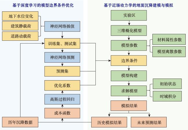
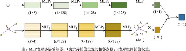
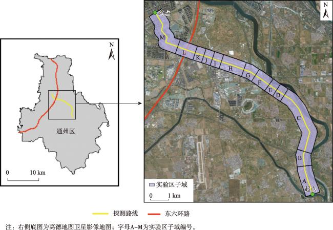
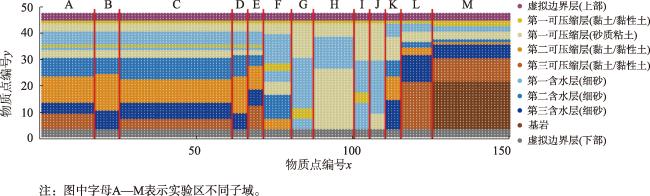
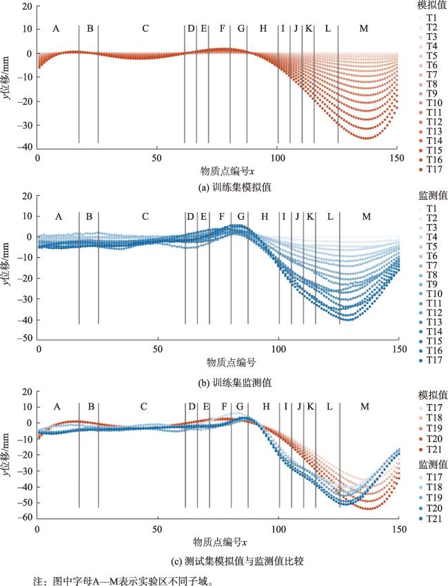
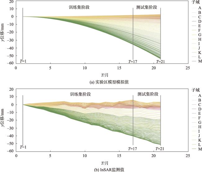
[Background] Physical model methods such as peridynamics, which offer the advantages of not requiring prior knowledge or continuity assumptions, are highly applicable to land subsidence modeling. However, the simulation accuracy of these modeling methods is limited by factors such as underground spatial structure and boundary conditions. Changes in groundwater levels, static building loads, and dynamic road loads can significantly impact the simulation results. Physical models and deep learning have naturally complementary strengths, and their integration represents a promising development direction, expected to enhance simulation accuracy. [Methods] This paper proposes a new approach to land subsidence modeling that combines peridynamics with deep learning methods. Based on using peridynamics to describe the physical processes of regional land subsidence, deep learning methods, including neural networks and Gaussian Process Regression, are employed to construct various boundary conditions that adapt to temporal developments and changes. This approach enables the optimization of boundary conditions within the peridynamics-based land subsidence model. [Results] In a case study of land subsidence in the Tongzhou District of Beijing from September 2021 to May 2023, the Root Mean Square Errors (RMSE) for the training and test sets of the peridynamics model combined with deep learning were 6.25 mm and 7.71 mm, respectively. Compared with the RMSE of 22.62 mm without Gaussian Process Regression, these results reflect a reduction of 72.37% and 65.92%, respectively. [Conclusions] Experimental results show that land subsidence modeling and simulation methods combining peridynamics and deep learning can significantly improve subsidence prediction accuracy. This approach to integrating physical models and artificial intelligence is highly applicable for regional land subsidence modeling and evolutionary studies.
Key words: peridynamics; physical model; deep learning; land subsidence; modeling; parameter optimization
CHENG Siyuan , GUAN Zhibo , GONG Huili , LI Xiaojuan , ZHANG Ke , WANG Che , LYU Mingyuan , GUO Lin , WANG Lin , LIU Yizhe . Land Subsidence Modeling and Simulation Methods Using Peridynamics and Deep Learning[J]. Journal of Geo-information Science, 2025 , 27(1) : 181 -192 . DOI: 10.12082/dqxxkx.2025.240506
表1 实验区模型离散参数Tab. 1 Discrete parameters of the land subsidence model |
| 参数名称 | 参数值 |
|---|---|
| x方向物质点间距 | 100 m |
| x方向物质点总数 | 150 |
| y方向物质点间距 | 10 m |
| y方向物质点总数 | 46(含虚拟边界层) |
| 近场邻域范围δ | 3倍点间距 |
| 临界伸长率 | 1(不考虑损伤); 0.044 72(考虑损伤) |
| 时间步长 | 1月 |
表2 实验区模型各子域边界条件系数Tab. 2 Boundary condition coefficients of subdomains of the land subsidence model |
| 子域 | 地下水位 变化系数 | 建筑密度 系数 | 道路密度 系数 | 子域 | 地下水位 变化系数 | 建筑密度 系数 | 道路密度 系数 | ||
|---|---|---|---|---|---|---|---|---|---|
| 模型左侧 | A | 1×10⁻⁴ | 1×10⁻³ | 1×10⁻³ | 模型右侧 | G | 5×10⁻⁴ | 1×10⁻⁴ | 1×10⁻⁴ |
| B | 1×10⁻⁴ | 1×10⁻³ | 1×10⁻³ | H | 5×10⁻⁴ | 1×10⁻³ | 3×10⁻³ | ||
| C | 1×10⁻⁴ | 1×10⁻³ | 1×10⁻³ | I | 5×10⁻⁴ | 9×10⁻³ | 5×10⁻⁴ | ||
| D | 1×10⁻² | 1×10⁻³ | 1×10⁻⁴ | J | 7×10⁻³ | 1×10⁻² | 1×10⁻⁴ | ||
| E | 1×10⁻² | 1×10⁻⁴ | 1×10⁻⁴ | K | 3×10⁻⁴ | 1×10⁻² | 4×10⁻³ | ||
| F | 1×10⁻² | 1×10⁻⁴ | 1×10⁻⁴ | L | 1×10⁻⁴ | 1×10⁻² | 1×10⁻² | ||
| M | 1×10⁻⁵ | 2×10⁻² | 1×10⁻² | ||||||
表3 实验区模型的模拟精度比较Tab. 3 Comparison of simulation accuracy of the land subsidence model (mm) |
| 本文方法RMSE | 对比方法 RMSE | ||
|---|---|---|---|
| 训练集 | 测试集 | ||
| 模型左侧 | 2.90 | 3.37 | 3.86 |
| 模型右侧 | 8.61 | 10.70 | 32.85 |
| 整体 | 6.25 | 7.71 | 22.62 |
注:本文方法指在高斯过程回归优化的边界条件系数下,结合深度学习的近场动力学地面沉降模拟方法;对比方法指使用未经高斯过程回归优化的边界条件系数的近场动力学地面沉降模拟方法。 |
利益冲突:Conflicts of Interest 所有作者声明不存在利益冲突。
All authors disclose no relevant conflicts of interest.
| [1] |
|
| [2] |
周成虎, 王华, 王成善, 等. 大数据时代的地学知识图谱研究[J]. 中国科学(地球科学), 2021, 51(7):1070-1079.
[
|
| [3] |
|
| [4] |
张兵. 遥感大数据时代与智能信息提取[J]. 武汉大学学报(信息科学版), 2018, 43(12):1861-1871.
[
|
| [5] |
|
| [6] |
|
| [7] |
|
| [8] |
|
| [9] |
|
| [10] |
|
| [11] |
吴志峰, 柴彦威, 党安荣, 等. 地理学碰上“大数据”:热反应与冷思考[J]. 地理研究, 2015, 34(12):2207-2221.
[
|
| [12] |
沈焕锋, 张良培. 地球表层特征参量反演与模拟的机理-学习耦合范式[J]. 中国科学:地球科学, 2023, 53(3):546-560.
[
|
| [13] |
|
| [14] |
|
| [15] |
|
| [16] |
|
| [17] |
于文, 宫辉力, 陈蓓蓓, 等. 北京东部平原区地面沉降时空演化特征及预测[J]. 自然资源遥感, 2022, 34(4):183-193.
[
|
| [18] |
|
| [19] |
|
| [20] |
|
| [21] |
|
| [22] |
|
| [23] |
|
| [24] |
|
| [25] |
任连伟, 周桂林, 顿志林, 等. 采空区建筑地基适宜性及沉降变形计算工程实例分析[J]. 岩土力学, 2018, 39(8):2922-2932,2940.
[
|
| [26] |
黄丹, 卢广达, 章青. 准静态变形破坏的近场动力学分析[J]. 计算力学学报, 2016, 33(5):657-662.
[
|
| [27] |
张可, 宫辉力, 李小娟, 等. 近场动力学理论在区域地面沉降建模中的应用研究[J]. 地球信息科学学报, 2023, 25(1):49-62.
[
|
| [28] |
张可. 基于近场动力学的地面沉降模型构建与应用研究——以北京通州为例[D]. 北京: 首都师范大学, 2023.
[
|
| [29] |
|
| [30] |
|
| [31] |
周超凡, 宫辉力, 陈蓓蓓, 等. 联合WT-RF的津保高铁沿线地面沉降预测[J]. 自然资源遥感, 2021, 33(4):34-42.
[
|
| [32] |
刘青豪, 张永红, 邓敏, 等. 大范围地表沉降时序深度学习预测法[J]. 测绘学报, 2021, 50(3):396-404.
[
|
| [33] |
|
| [34] |
朱琳, 宫辉力, 李小娟, 等. 区域地面沉降研究进展与展望[J]. 水文地质工程地质, 2023, 51(4):167-177.
[
|
| [35] |
曹鑫宇, 朱琳, 宫辉力, 等. AM-LSTM网络的北京平原东部地面沉降模拟[J]. 遥感学报, 2022, 26(7):1302-1314.
[
|
| [36] |
|
| [37] |
|
| [38] |
|
| [39] |
|
| [40] |
彭文祥, 张德英. 基于LSTM与Transformer的地面沉降智能预测方法研究——以上海市为例[J]. 时空信息学报, 2024, 31(1):94-103.
[
|
| [41] |
|
| [42] |
|
| [43] |
|
| [44] |
|
| [45] |
王霖. 南水北调背景下北京平原区地面沉降演化特征分析及预测[D]. 北京: 首都师范大学, 2024.
[
|
/
| 〈 |
|
〉 |