
Journal of Geo-information Science >
Remote Sensing Data Intelligence: Progress and Perspectives
Received date: 2024-11-13
Revised date: 2025-01-09
Online published: 2025-01-24
Supported by
The National Key Research and Development Program of China(2023YFF1304301)
The Second Tibetan Plateau Scientific Expedition and Research Program(2019QZKK030701)
The Strategic Priority Research Program of the Chinese Academy of Sciences(XDA19090300)
The Key Program of National Natural Science Foundation of China(61731022)
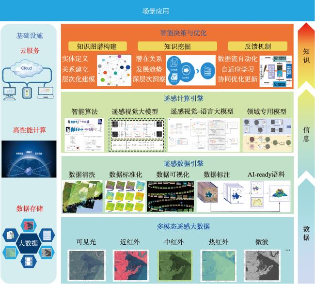
[Significance] Data resources have become pivotal in modern production, evolving in close synergy with advancements in artificial intelligence (AI) technologies, which continuously cultivate new, high-quality productive forces. Remote sensing data intelligence has naturally emerged as a result of the rapid expansion of remote sensing big data and AI. This integration significantly enhances the efficiency and accuracy of remote sensing data processing while bolstering the ability to address emergencies and adapt to complex environmental changes. Remote sensing data intelligence represents a transformative approach, leveraging state-of-the-art technological advancements and redefining traditional paradigms of remote sensing information engineering and its applications. [Analysis] This paper delves into the technological background and foundations that have facilitated the emergence of remote sensing data intelligence. The rapid development of technology has provided robust support for remote sensing data intelligence, primarily in three areas: the advent of the big data era in remote sensing, significant advancements in remote sensing data processing capabilities, and the flourishing research on remote sensing large models. Furthermore, a comprehensive technical framework is proposed, outlining the critical elements and methodologies required for implementing remote sensing data intelligence effectively. To demonstrate the practical applications of remote sensing data intelligence, the paper presents a case study on applying these techniques to extract ultra-high-resolution centralized and distributed photovoltaic information in China. [Results] By integrating large models with remote sensing data, the study demonstrates how remote sensing data intelligence enables precise identification and mapping of centralized and distributed photovoltaic installations, offering valuable insights for energy management and planning. The effectiveness of remote sensing data intelligence in addressing challenges associated with large-scale photovoltaic extraction underscores its potential for application in critical fields. [Prospect] Finally, the paper provides an outlook on areas requiring further study in remote sensing data intelligence. It emphasizes that high-quality data serves as the foundation for remote sensing data intelligence and highlights the importance of constructing AI-ready knowledge bases and recognizing the value of small datasets. Developing targeted and efficient algorithms is essential for achieving remote sensing intelligence, making the advancement of practical data intelligence methods an urgent research priority. Furthermore, promoting multi-level services for remote sensing data, information, and knowledge through data intelligence should be prioritized. This research provides a comprehensive technical framework and forward-looking insights for remote sensing data intelligence, offering valuable references for further exploration and implementation in critical fields.

HE Guojin , LIU Huichan , YANG Ruiqing , ZHANG Zhaoming , XUE Yuan , AN Shihao , YUAN Mingruo , WANG Guizhou , LONG Tengfei , PENG Yan , YIN Ranyu . Remote Sensing Data Intelligence: Progress and Perspectives[J]. Journal of Geo-information Science, 2025 , 27(2) : 273 -284 . DOI: 10.12082/dqxxkx.2025.240630
表1 主要遥感大模型汇总Tab. 1 Summary of major remote sensing large models |
| 遥感大模型 | 发布时间 | 主要发布机构 | 特点 |
|---|---|---|---|
| RingMo | 2022.07 | 中国科学院空天信息创新研究院牵头 | 首个跨模态遥感数据的生成式预训练大模型 |
| RingMo V3 | 2024.09 | 中国科学院空天信息创新研究院、鹏城实验室 | 适用多类型传感器、观测平台数据以及多类型任务 |
| SpectralGPT | 2023.11 | 中国科学院空天信息创新研究院牵头 | 适用于高光谱遥感数据 |
| SkySense | 2023.12 | 武汉大学、蚂蚁集团 | 应用范围广泛且精细 |
| AIE-SEG | 2023.10 | 阿里达摩院 | 多模态交互、全要素提取、交互式结果修正 |
| EarthGPT | 2024.01 | 北京理工大学 | 跨模态相互理解 |
| CrossEarth | 2024.10 | 中山大学、中国科学技术大学、武汉大学 | 全球首个专注于遥感跨域泛化的语义分割视觉大模型 |
| GeoChat | 2023.11 | 阿联酋人工智能大学牵头 | 问答式交互、视觉定位 |
| Prithvi-EO-2.0 | 2024.12 | NASA、IBM牵头 | 支持多种应用场景与处理任务 |
| [1] |
|
| [2] |
梁顺林, 白瑞, 陈晓娜, 等. 2019年中国陆表定量遥感发展综述[J]. 遥感学报, 2020, 24(6):618-671.
[
|
| [3] |
何国金, 王力哲, 马艳, 等. 对地观测大数据处理:挑战与思考[J]. 科学通报, 2015, 60(5):470-478.
[
|
| [4] |
吴田军, 骆剑承, 李曼嘉, 等. 地理时空数字化底座理论框架构建与应用实践[J]. 地球信息科学学报, 2024, 26(4):799-830.
[
|
| [5] |
李德仁, 丁霖, 邵振峰. 面向实时应用的遥感服务技术[J]. 遥感学报, 2021, 25(1):15-24.
[
|
| [6] |
张永军, 万一, 史文中, 等. 多源卫星影像的摄影测量遥感智能处理技术框架与初步实践[J]. 测绘学报, 2021, 50(8):1068-1083.
[
|
| [7] |
龚健雅, 张觅, 胡翔云, 等. 智能遥感深度学习框架与模型设计[J]. 测绘学报, 2022, 51(4):475-487.
[
|
| [8] |
何国金, 焦伟利, 龙腾飞, 等. 遥感信息工程[M]. 北京: 科学出版社, 2021.
[
|
| [9] |
Union of Concerned Scientists. Union of Concerned Scientists Satellite Database[DB/OL]. (2023-05-01) [2024-10-18]. https://www.ucsusa.org/resources/satellite-database
|
| [10] |
7wData. Terabytes From Space: Satellite Imaging Fills Data Centers[N/OL].(2020-05-01) [2024-12-25]. https://7wdata.be/cloud-computing/terabytes-from-space-satellite-imagng-fills-data-centers/
|
| [11] |
MAXAR. Maxar is a Leading Provider of Secure, Precise Geospatial Insights[DB/OL].(2023-05-01) [2024-12-25]. https://maxar.com/maxar-intelligence/about
|
| [12] |
廖小罕. 中国对地观测20年科技进步和发展[J]. 遥感学报, 2021, 25(1):267-275.
[
|
| [13] |
孙伟伟, 杨刚, 陈超, 等. 中国地球观测遥感卫星发展现状及文献分析[J]. 遥感学报, 2020, 24(5):479-510.
[
|
| [14] |
邹同元, 丁火平, 王玮哲, 等. 天基遥感大数据人工智能应用探讨[J]. 卫星应用, 2019(6):38-44.
[
|
| [15] |
国家遥感数据与应用服务平台. 高分卫星运行与数据分发报告-2024年8月[EB/OL]. (2024-10-10) [2024-10-18]. https://www.cpeos.org.cn/home/#/gfNews
[ China Platform of Earth Observation System. GF Satellite Operations and Data Distribution Report- August 2024[EB/OL].(2024-10-10) [2024-10-18]. https://www.cpeos.org.cn/home/#/gfNews
|
| [16] |
魏昆. 中国遥感卫星地面站:仰望星空的“数据驿站”[N/OL].(2024-10-04) [2024-10-24]. https://aircas.cas.cn/dtxw/cmsm/202410/t20241024_7407687.html
[
|
| [17] |
何国金, 郑铠沅, 杨瑞清, 等. 遥感大数据赋能青藏高原陆表水体空间分布信息认知[J]. 中国水利, 2024(11):56-66.
[
|
| [18] |
张兵. 遥感大数据时代与智能信息提取[J]. 武汉大学学报(信息科学版), 2018, 43(12):1861-1871.
[
|
| [19] |
许子明, 田杨锋. 云计算的发展历史及其应用[J]. 信息记录材料, 2018, 19(8):66-67.
[
|
| [20] |
Synergy Research Group. Cloud Market Growth Surge Continues in Q3-Growth Rate Increases for the Fourth Consecutive Quarter[EB/OL].(2024-11-01) [2024-11-07]. https://www.srgresearch.com/articles/cloud-market-growth-surge-continues-in-q3-growth-rate-increases-for-the-fourth-consecutive-quarter
|
| [21] |
国家数据局. 数字中国发展报告(2023年)[EB/OL].(2024-06-30) [2024-11-07]. https://www.digitalchina.gov.cn/2024/xwzx/szkx/202406/P020240630600725771219.pdf
[ National Data Administration. Digital China development report(2023)[EB/OL].(2024-06-30) [2024-11-07] ]. https://www.digitalchina.gov.cn/2024/xwzx/szkx/202406/P020240630600725771219.pdf
|
| [22] |
闾国年, 袁林旺, 陈旻, 等. 地理信息学科发展的思考[J]. 地球信息科学学报, 2024, 26(4):767-778.
[
|
| [23] |
|
| [24] |
向鹏. 周成虎院士:从遥感大数据到遥感大模型[J]. 高科技与产业化, 2023, 29(9):16-19.
[
|
| [25] |
张良培, 张乐飞, 袁强强. 遥感大模型:进展与前瞻[J]. 武汉大学学报(信息科学版), 2023, 48(10):1574-1581.
[
|
| [26] |
|
| [27] |
|
| [28] |
|
| [29] |
|
| [30] |
|
| [31] |
|
| [32] |
|
| [33] |
|
| [34] |
|
| [35] |
郭华东. 科学大数据——国家大数据战略的基石[J]. 中国科学院院刊, 2018, 33(8):768-773.
[
|
| [36] |
郭华东. 地球大数据科学工程[J]. 中国科学院院刊, 2018, 33(8):818-824.
[
|
| [37] |
|
| [38] |
何国金, 王桂周, 龙腾飞, 等. 对地观测大数据开放共享:挑战与思考[J]. 中国科学院院刊, 2018, 33(8):783-790.
[
|
| [39] |
陆锋, 诸云强, 张雪英. 时空知识图谱研究进展与展望[J]. 地球信息科学学报, 2023, 25(6):1091-1105.
[
|
| [40] |
乔红. 2024年人工智能十大前沿技术趋势展望[R]. 世界科技与发展论坛,北京, 2024-10-23.
[
|
| [41] |
|
| [42] |
Food and Agriculture Organization of the United Nations. Global forest resources assessment 2020: terms and definitions FRA 2020 [EB/OL]. Forest Resources Assessment Working Paper 188. Rome: FAO, 2020 [2024-11-09]. https://openknowledge.fao.org/server/api/core/bitstreams/531a9e1b-596d-4b07-b9fd-3103fb4d0e72/content
|
| [43] |
秦枭. “AI教母”创业瞄准空间智能[N]. 中国经营报, 2024-05-13(C01).
[
|
| [44] |
王桥. 地表异常遥感探测与即时诊断方法研究框架[J]. 测绘学报, 2022, 51(7):1141-1152.
[
|
/
| 〈 |
|
〉 |
