
Journal of Geo-information Science >
Road Network Pattern Recognition Using Graph Representation Learning of Geometric Similarity
Received date: 2024-08-23
Revised date: 2024-11-14
Online published: 2025-09-09
Supported by
National Natural Science Foundation of China(42130112)
National Natural Science Foundation of China(42371479)
National Natural Science Foundation of China(41901335)
Key Laboratory of Smart Earth(KF2023ZD04-02)
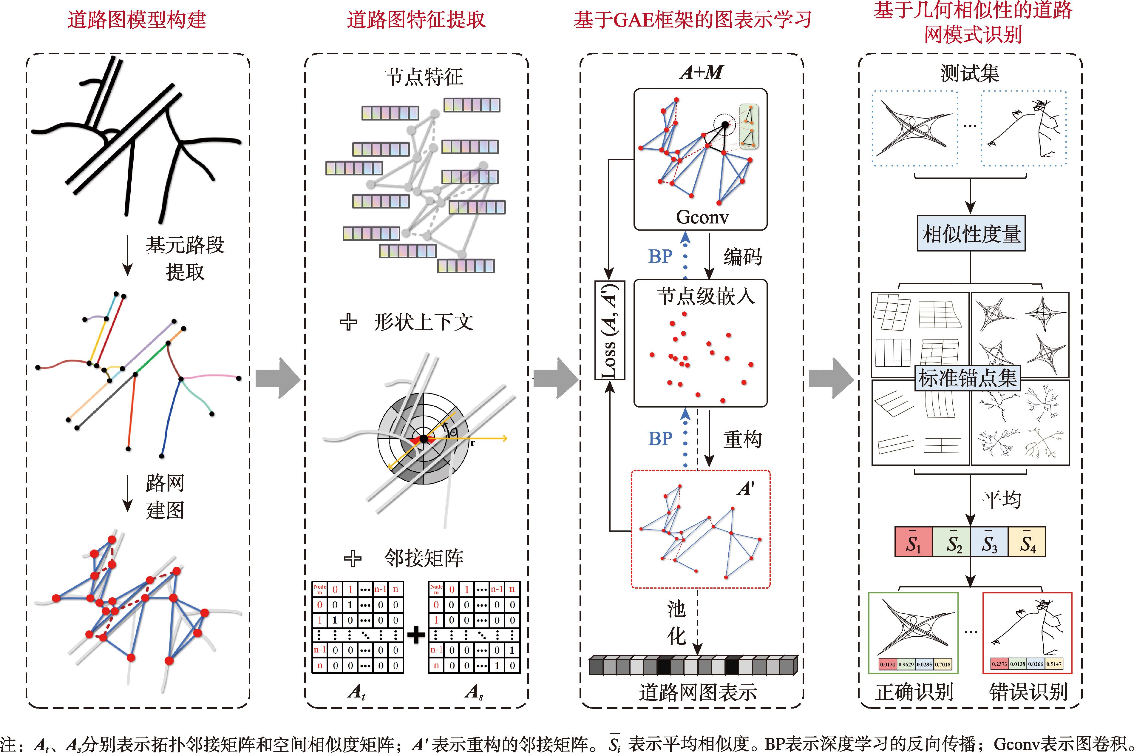
[Objectives] Abstract: As a fundamental geographic feature, road networks play a crucial role in spatial analysis and various applications. This paper studies vector data embedding models for road networks and their application in road network pattern recognition. These models not only facilitate the analysis of the spatial structure of road networks but also provide computational methods for information representation and processing in the digital twin of the Earth system. However, most existing road network pattern recognition methods are computationally complex, lack intelligent reasoning capabilities, rely heavily on large amounts of labeled data, and exhibit limited generalization ability. These limitations constrain their performance in pattern recognition under complex road network structures. [Methods] To address these challenges, this paper proposes a novel identification method based on geometric similarity graph representation learning, tailored for road network pattern recognition tasks. Firstly, the road network is modeled using spatial dual graphs, with graph node features designed based on cognitive heuristics to capture the intrinsic characteristics of the road network. Next, the model is trained in an unsupervised manner. Subgraph Isomorphism Counting (SIC) is introduced during road embedding learning to capture local structural patterns, while a Global Context Attention mechanism (GCA) is incorporated during graph embedding generation to capture global context, thereby enhancing the model's representation performance. Finally, geometric similarity in graph-level embeddings was utilized to effectively recognize road network patterns. To validate the effectiveness of the proposed method, a dataset containing five types of road network patterns was constructed, and extensive experiments were conducted. [Results] The SUGAR-3 model proposed in this paper achieved a classification accuracy of 93.18%, representing an improvement of more than 12% over classical road network pattern recognition methods and significantly outperforming baseline models such as Graph Convolutional Neural Networks (GCNN). Furthermore, an in-depth analysis of the graph embeddings and the model's expressive power was performed. The results demonstrate that the road network patterns represented by our model can be effectively clustered, forming clear boundaries between different patterns. [Conclusions] This verifies the effectiveness of SIC and GCA in enhancing road network pattern recognition performance and provides a new approach for further improving the expressive power of graph embeddings for road networks.
HOU Yang , YANG Jian , FANG Li , ZHANG Bianying , ZHANG Meng , XIE Xiao , ZHENG Chenghao . Road Network Pattern Recognition Using Graph Representation Learning of Geometric Similarity[J]. Journal of Geo-information Science, 2025 , 27(9) : 2052 -2069 . DOI: 10.12082/dqxxkx.2025.240465
利益冲突:Conflicts of Interest 所有作者声明不存在利益冲突。
All authors disclose no relevant conflicts of interest.
| [1] |
|
| [2] |
|
| [3] |
|
| [4] |
马超, 孙群, 陈换新, 等. 利用路段分类识别复杂道路交叉口[J]. 武汉大学学报(信息科学版), 2016, 41(9):1232-1237.
[
|
| [5] |
何亚坤, 艾廷华, 杜欣, 等. 网络空间向量剖分法识别城市路网网格模式[J]. 武汉大学学报(信息科学版), 2018, 43(1):138-144.
[
|
| [6] |
徐云滔, 张圆, 李精忠, 等. 使用LightGBM识别城市道路格网模式[J]. 测绘科学技术, 2020, 8(1):1-8.
[
|
| [7] |
王安东, 武芳, 巩现勇, 等. 一种城市路网多层次复合网格模式识别方法[J]. 测绘学报, 2023, 52(11):1994-2006.
[
|
| [8] |
|
| [9] |
|
| [10] |
徐柱, 蒙艳姿, 李志林, 等. 基于有向属性关系图的典型道路交叉口结构识别方法[J]. 测绘学报, 2011, 40(1):125-131.
[
|
| [11] |
|
| [12] |
李豪, 郭黎, 王云阁, 等. 利用路段连接图识别道路网中的格网模式[J]. 武汉大学学报(信息科学版), 2022, 47(1):126-132.
[
|
| [13] |
|
| [14] |
|
| [15] |
杨铭, 杨剑, 侯洋, 等. 一种基于改进邻域聚合的路网图嵌入匹配方法[J]. 地球信息科学学报, 2024, 26(10):2335-2351.
[
|
| [16] |
|
| [17] |
|
| [18] |
|
| [19] |
|
| [20] |
|
| [21] |
王米琪, 艾廷华, 晏雄锋, 等. 图卷积网络模型识别道路正交网格模式[J]. 武汉大学学报(信息科学版), 2020, 45(12):1960-1969.
[
|
| [22] |
|
| [23] |
|
| [24] |
|
| [25] |
|
| [26] |
|
| [27] |
|
| [28] |
|
| [29] |
|
| [30] |
|
| [31] |
|
| [32] |
|
| [33] |
|
| [34] |
|
| [35] |
高原, 王洁, 李钢, 等. 城市用地功能精细化识别方法:时序动态图嵌入深度学习模型[J]. 地球信息科学学报, 2022, 24(10):1968-1981.
[
|
| [36] |
|
| [37] |
唐曾杨, 艾廷华, 徐海江. 地理知识图谱下的建筑群空间分布模式推理[J]. 地球信息科学学报, 2023, 25(6):1202-1214.
[
|
| [38] |
何海威, 钱海忠, 谢丽敏, 等. 立交桥识别的CNN卷积神经网络法[J]. 测绘学报, 2018, 47(3):385-395.
[
|
| [39] |
|
| [40] |
|
| [41] |
|
/
| 〈 |
|
〉 |