费茉莉 , 刘苇航, 王席, 李梦雅, 黄清雨, 王军
1. 华东师范大学 地理信息科学教育部重点实验室,上海 200241;2. 华东师范大学地理科学学院,上海 200241
FEI Moli, LIU Weihang, WANG Xi, LI Mengya, HUANG Qingyu, WANG Jun
通讯作者:
收稿日期: 2017-02-13
修回日期: 2017-03-30
网络出版日期: 2017-07-10
版权声明: 2017 《地球信息科学学报》编辑部 《地球信息科学学报》编辑部 所有
基金资助:
作者简介:
作者简介:费茉莉(1992-),女,浙江人,硕士生,主要从事内涝灾害风险研究。E-mail:51153901061@ecnu.edu.cn
展开
摘要
本文采用“Vegetation-Impervious Surface-Soil”模型和线性光谱混合分解方法,获取像元中不透水面、植被、土壤覆盖信息,用于计算SCS模型产流参数综合CN(Curve Number)值;基于土地利用类型,采用经验值与数值实验逐步求精相结合的方法,确定水动力汇流模型参数曼宁系数,并用实测积水数据验证两次参数修正的模拟效果。以上海中心城区为例进行验证,研究结果表明:①将采用V-I-S模型得到的不透水面、植被、土壤信息设定CN值,能够降低积水分布的极值化现象,提高SCS产流模型产流量和产流分布精度;②采用经验法和数值模拟逐步求精法,按土地利用类型设定曼宁系数,使各时段最大积水深度高于原模型,说明曼宁系数是汇流模型的敏感参数。
关键词:
Abstract
This paper aims to optimize the performance of a previously developed hydrodynamic model for urban flood simulation. Our major task includes calibration of two key parameters in the runoff generation and flood routing modules, and verification of the precision of the model output. In the runoff producing module, we focused on optimization of Curve Number (CN) values. To achieve this purpose, the method of Linear Spectral Mixture Analysis (LSMA) was employed to extract terrestrial information of vegetation coverage, soil categories and impervious land use from Landsat TM images, based on which a specific CN value could be defined for each unit in the hydrodynamic model. As for the flood routing module, we reset the manning coefficient via integrating previous empirical value and findings from calibration experiments conducted in this study. Verification experiments show both the calibration of CN values and manning coefficient promotes the model's simulation precision. Using the Vegetation-Impervious Surface-Soil (V-I-S) raster layers, in which the CN values incorporate more accurate information of vegetation coverage and soil categories, as input for the hydrodynamic model, are able to lower the extreme abnormal values of simulated water depth, and provide more reasonable estimation of water volume and inundation area. After resetting the manning coefficient for different land uses, the simulated maximum water depth increased notably (almost 100 mm), compared with previous model outputs without calibration of this parameter. Through our calibration study, it is safe to say that manning coefficient is a sensitive and critical parameter and deserves further attention in the extension research for optimization of the flood routing module.
Keywords:
利用高精度洪涝模型开展城市暴雨洪涝模拟是城市防洪减灾的关键技术环节,也是提高城市洪涝风险管理水平的重要途径。暴雨径流过程包括产流和汇流2个重要阶段。目前,通用产流经验公式有:对土壤资料要求较高的Green-Ampt渗透公式[1];适用于小流域的Horton渗透公式[2];能够客观反映土壤类型和土壤含水量,适用于大流域的SCS-CN法[3]。汇流方法中基于圣维南方程(Saint-Venant)的水动力方法较为常用,除坡度外,坡面地表曼宁糙率系数在汇流过程中发挥重要作用。前期,以上海中心城区为研究对象,将GIS与水文/水动力模型结合,开发了城市暴雨内涝产汇流模拟工具,该工具能较好地模拟城市积水状况[4],但不能很好体现产汇流参数的空间差异,导致模拟精度偏低。本文在前期研究的基础上,对产流和汇流模块进行参数修正,实现了模型精度的进一步提升。研究内容包括:①基于遥感影像,获取不透水面等地表覆盖物信息,用于计算产流参数CN值;②对不同土地利用类型的曼宁系数进行修正;③分别用修正CN值和产汇流参数均修正后的模型进行百年一遇强度下积水模拟,并将实测积水数据与模拟结果对比,验证了参数修正的有效性。
本文以上海外环线为界的中心城区为研究区,面积约660 km2,地面高程3 m左右。因高度城市化,城市不透水面占比迅速增加,另受地面沉降、排水管网老化等因素影响,该区域已成为暴雨内涝高风险区。
本文使用的数据包括上海中心城区DEM数据、土地利用数据、Landsat TM5影像以及土壤分类数据。2012年DEM数据空间分辨率为20 m,由2005年等高线(由1 456 686个高程点生成)插值并叠加2005-2012年地面沉降量得到,并对道路、建筑部分进行了高程调整,以便能更真实地反映对径流过程的阻塞作用。根据模型修正需要,将2012年土地利用数据划分为3大类及13小类,土壤数据分为4类,遥感影像进行了辐射校正和大气校正。
城市暴雨内涝产汇流模拟工具主要包括降雨、产流、汇流3个模块[4],降雨模块采用设计暴雨模型和适合城市地区的芝加哥雨型进行不同强度降雨模拟,产流模块采用修正后SCS模型,汇流模块采用以圣维南方程为基础的二维水动力模拟法。
3.1.1 SCS-CN模型
SCS产流模型由美国农业部水土保持局提出,常用于模拟预测降雨事件下地表径流过程(式(1))。
式中:Q为径流量;P为降雨量;S'为土壤饱和储水量;Ia为初损值,包括截流、表层蓄水等,可表示为Ia=λS'。根据上海地区下垫面条件,将初损值由初始0.2调整为0.05[5],公式如式(2)所示。
因不易直接获得S',故引入Curve Number(CN)参数进行计算(式(3))。
式中:CN值是无量纲参数,与土壤质地、土地利用方式和降雨前土壤湿润状况有关。在降雨量已知,求算径流量时,只需求出CN值。CN值的准确度也直接影响产流量和最终模拟效果。
3.1.2 CN值修正
传统SCS-CN方法计算径流时,常将CN及径流量变化平均化或块状化。Moglen[6]以像元为单位,提出了加权径流曲线数法,该方法能较好地体现径流空间变化特征。Canters等[7]以像元为单位,结合不透水面、植被、裸土、水体及阴影信息,在流域尺度上计算了CN。本文尝试在上海地区将不透水面等信息引入到CN计算中。
用Landsat影像提取不透水面等地表覆盖信息效果较好[8],但TM影像存在混合像元问题。本文选用“Vegetation-Impervious Surface-Soil”(V-I-S)像元分解模型和线性光谱混合分解技术进行像元分解。
将提取的3类端元的比例作为权重,用于综合CN值计算,计算公式如式(4)[9]所示。植被和土壤端元CN值由CN参考值调整得到(表1、2),不透水面端元CN值取98。
式中:CNc、CNISA、CNv、CNs分别为综合CN,不透水面CN,植被CN和土壤CN;ISA、V、S为不透水面、植被和土壤在像元中的面积比例;每个像元综合CN是各端元CN的加权组合。
表2 植被CN值表
Tab. 2 CN value of different kinds of vegetation.
| 植被类型 | NDVI | 植被覆盖度(V)/% | 分级 | CN |
|---|---|---|---|---|
| 林地 | ≥0.65 | <50 | 差 | 77 |
| 50≤V<75 | 中等 | 73 | ||
| >75 | 好 | 70 | ||
| 草地 | 0.3≤NDVI<0.65 | <50 | 差 | 82 |
| 50≤V<75 | 中等 | 76 | ||
| ≥75 | 好 | 72 | ||
| 非植被 | <0.3 | - | 82 |
3.2.1 汇流模型
汇流方法选用水动力模型法[4,10],该方法以圣维南连续方程为基础(式(5)),选用曼宁公式(式(6)),求解Qx、Qy,联立式(5)和式(6)可离散求解各栅格上的积水量。
式中:h为内涝积水深度;t为时间;Qx、Qy为x、y方向上单宽流量;re为暴雨产流。
式中:w为栅格宽度;dx、dy为x、y方向上有效水深;S0x、S0y为x、y方向上坡度比降;n为曼宁系数。
3.2.2 曼宁系数修正
城市区域不同土地利用类型因地表糙度不同,对地表径流过程有明显的影响[11]。本文借鉴自然河道浅水模型对曼宁系数的率定思路,对不同土地利用类型分别设置曼宁系数[12]。修正时结合实测和水利工程经验值[13-14],在模糊的土地利用类型分类的基础上进一步细化分类,并在后期试验中逐步求精,获得最佳值(表3)。
表3 土地类型的曼宁系数
Tab. 3 Manning coefficient of different land use types
| 土地类型 | 土地亚类 | 曼宁系数 |
|---|---|---|
| 植被(绿) | 农田 林地 公园 绿地 | 0.23 0.85 0.22 0.21 |
| 水体(蓝) | 河流 湖泊 坑塘 | 0.20 0.20 0.20 |
| 人工(灰) | 新式住宅 旧式住宅 自然村落 铁路航空 道路 其它 | 0.08 0.14 0.20 0.14 0.20 0.20 |
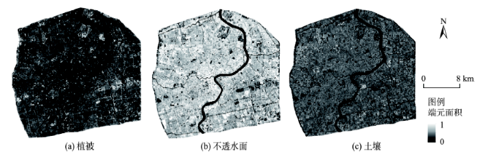
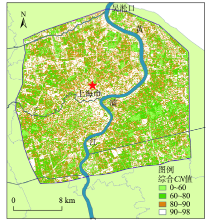
根据像元分解方法求得各端元盖度图(图1)。上海中心城区2012年不透水面比例达70%左右,与相关研究结论相符[15]。将3类端元栅格图及对 应CN值代入式(4)得到综合CN栅格图(图2)。
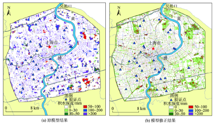
将原来按土地利用类型设定CN值的方式更改为直接读取CN栅格,进行径流计算。模拟时降雨强度设为100年一遇,输出最大积水深度分布图,与原模型百年一遇降雨下模拟结果对比(图3)。结果表明,CN修正后解决了原模型积水分布极值化现象,多数用地类型积水深度较原模型有所减少。这是由于原模型假定同一用地的CN值均相同,而修正CN值时,考虑了各种用地类型内部的渗透性能分布差异,算得CN值小于原模型。由上海地区暴雨强度计算公式计算得到,百年一遇强度下2 h总雨量约为222.85 mm[4],且中心城区地势低平,建筑密度高,积水流动性较弱,CN修正后大部分区域积水深度在200 mm以下,与总降雨量相吻合。
图3 百年一遇降雨最大积水分布模型修正前后结果对比图
Fig. 3 Comparison of simulation results under different CN values
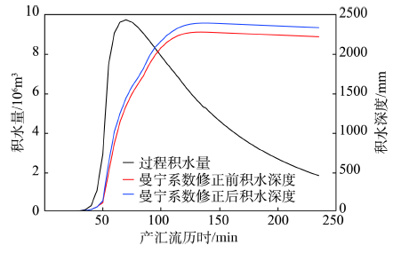
修正曼宁系数前后水动力模拟法结果表明,最大积水深度到达积水量峰值时刻后都呈现上升趋势(图4)。依据Hunter等[11]的研究,曼宁系数在内涝衰退阶段属敏感参数,这与曼宁系数是浅水波运动的敏感参数有很强的联系,积水逐渐消退过程,汇流水波的浅水波性质更明显,因而曼宁系数的敏感性被放大了。而修正曼宁系数后各时段最大积水深度均大于曼宁系数修正前,是因为修正后多数曼宁系数小于原系数。据Bates等[16]的研究,当曼宁系数较小时地表没有足够能力来阻滞水流,地表多形成片流和浅水集中流,局部低点可汇集更深水流。
图4 积水过程对曼宁系数修正的响应
Fig. 4 The response of water accumulation process to manning coefficient modification
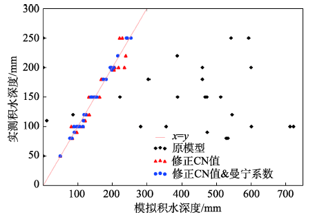
为进一步检验CN值及曼宁系数的修正效果,选用同等降雨强度下2 h实测积水数据进行了验证。因现存道路积水监测数据较为全面,最终在中心城区路网上选取30个点作验证。结果表明(图5),CN修正后模拟结果较原模型更接近实测数据,均方根误差为13.85,比原始模型误差显著减小,基于不透水面的CN值设定方法较为可靠。同时修正CN值和曼宁系数的结果较仅修正CN值的结果更接近实测数据,均方根误差为6.19,说明基于土地利用的曼宁系数设定方法较为可靠。
(1)本文采用V-I-S模型和约束性线性光谱混合分解方法,获取研究区不透水面、植被和土壤3端元盖度信息,计算得到SCS产流模型参数综合CN值,并用于研究区积水模拟。与道路实测积水数据对比,发现模拟精度相比原模型有很大的提升。说明此方法可用于城市CN值的计算,并能获得合理的产流数据。
(2)依据土地利用类型,采用经验值和数值模拟逐步求精法,设定具有空间差异的汇流模型参数曼宁系数,用于研究区汇流模拟,结果表明曼宁系数的敏感性在到达积水量峰值后表现出上升趋势。曼宁系数修正后产汇流各时段最大积水深度均大于修正前,表明曼宁系数的修正对汇流速率及栅格汇流量有较大的影响。与道路实测积水数据对比发现,模拟精度优于原模型和仅修改CN值后的结果,说明本文方法可用于汇流计算,并能获得合理的积水分布数据。
The authors have declared that no competing interests exist.
| [1] |
An approach toward a physical interpretation of infiltration capacity [J].https://doi.org/10.2136/sssaj1941.036159950005000C0075x URL [本文引用: 1] 摘要
Publication » An Approach Toward a Physical Interpretation of Infiltration-Capacity1.
|
| [2] |
Studies on soil physics: 1. Flow of air and water through soils [J]. |
| [3] |
Engineering handbook, section 4: Hydrology [S]. |
| [4] |
暴雨内涝危险性情景模拟方法研究——以上海中心城区为例 [J].https://doi.org/10.3724/SP.J.1047.2016.00506 URL Magsci [本文引用: 4] 摘要
<p>本文采用地理信息系统技术(GIS)与水文/水动力学相结合的方法,使用修正的SCS模型进行产流模拟,利用局部等体积法和水动力模型进行汇流模拟,建立了基于情景的城市暴雨内涝危险性模拟工具,并对相同雨强情景下不同汇流模型的模拟结果与精度进行了对比分析。结果表明:(1)局部等体积法计算简单,对降雨的时程分配较为敏感,峰前历时和雨强对结果影响显著,较适合于雨型确定的城市暴雨内涝危险性快速模拟;水动力模型计算复杂,与整个降雨历时存在明显关系,模拟精度较高。(2)利用台风“麦莎”带来强降雨导致的积水实测数据,对模拟结果进行对比和验证,表明本文建立的水动力模型法模拟结果与实测降雨积水更为接近,更适合上海中心城区暴雨内涝危险性情景模拟。</p>
Research on the scenario simulation method of rainstorm waterlogging hazard: A case study in the central urban area of shanghai [J].https://doi.org/10.3724/SP.J.1047.2016.00506 URL Magsci [本文引用: 4] 摘要
<p>本文采用地理信息系统技术(GIS)与水文/水动力学相结合的方法,使用修正的SCS模型进行产流模拟,利用局部等体积法和水动力模型进行汇流模拟,建立了基于情景的城市暴雨内涝危险性模拟工具,并对相同雨强情景下不同汇流模型的模拟结果与精度进行了对比分析。结果表明:(1)局部等体积法计算简单,对降雨的时程分配较为敏感,峰前历时和雨强对结果影响显著,较适合于雨型确定的城市暴雨内涝危险性快速模拟;水动力模型计算复杂,与整个降雨历时存在明显关系,模拟精度较高。(2)利用台风“麦莎”带来强降雨导致的积水实测数据,对模拟结果进行对比和验证,表明本文建立的水动力模型法模拟结果与实测降雨积水更为接近,更适合上海中心城区暴雨内涝危险性情景模拟。</p>
|
| [5] |
城市化地区径流系数及其应用 [J].Urbanized area runoff coefficient and its application [J]. |
| [6] |
Effect of orientation of spatially distributed curve numbers in runoff calculations [J].https://doi.org/10.1111/j.1752-1688.2000.tb05734.x URL [本文引用: 1] 摘要
ABSTRACT: The NRCS curve number approach to runoff estimation has traditionally been to average or "lump" spatial variability into a single number for purposes of expediency and simplicity in calculations. In contrast, the weighted runoff curve number approach, which handles each individual pixel within the watershed separately, tends to result in larger estimates of runoff than the lumped approach. This work proposes further enhancements that consider not only spatial variability, but also the orientation of this variability with respect to the flow aggregation pattern of the drainage network. Results show that the proposed enhancements lead to much reduced estimates of runoff production. A revised model that considers overland flow lengths, consistent with existing NRCS concepts is proposed, which leads to only mildly reduced runoff estimates. Although more physically-based, this revised model, which accounts directly for spatially distributed curve numbers and flow aggregation, leads to essentially the same results as the original, lumped runoff model when applied to three study watersheds. Philosophical issues and implications concerning the appropriateness of attempting to disaggregate lumped models are discussed.
|
| [7] |
Effects of different methods for estimating impervious surface cover on runoff estimation at catchment level [C]. |
| [8] |
基于混合光谱分解的城市不透水面分布估算 [J].https://doi.org/10.3321/j.issn:1007-4619.2007.06.020 URL Magsci [本文引用: 1] 摘要
城市化的一个重要表现就是不透水面分布比率的上升,城市内部不透水面分布是城市生态环境的一 个重要指标。对于规模较大的大城市,采用高性价比的中等分辨率影像,获取不透水面的分布,是当前国际研究的一个热点。本研究利用Landsat 7的ETM+影像,在线性光谱分解的技术上,提取了上海市的不透水面分布并对其空间特征进行了分析。研究揭示,ETM+影像对于城市尺度的信息提取,其成 本是较低的;对于城市地域来说,利用植被、高反照度、低反照度和裸露的土壤四种最终光谱端元的线性组合,可以较好地模拟ETM+波谱特征,而除了水面以外 的高反照度、低反照度两种最终光谱端元,可以较好地表达城市不透水表面信息。结果显示,利用中等分辨率影像对上海中心城区不透水面分布提取的精度还是令人 满意的,总体上,上海市不透水面分布比率较高,不透水面分布的空间差异进一步揭示了城市土地覆被空间结构以及城市空间扩展的差异性。
Urban impervious surface distribution estimation by spectral mixture analysis [J].https://doi.org/10.3321/j.issn:1007-4619.2007.06.020 URL Magsci [本文引用: 1] 摘要
城市化的一个重要表现就是不透水面分布比率的上升,城市内部不透水面分布是城市生态环境的一 个重要指标。对于规模较大的大城市,采用高性价比的中等分辨率影像,获取不透水面的分布,是当前国际研究的一个热点。本研究利用Landsat 7的ETM+影像,在线性光谱分解的技术上,提取了上海市的不透水面分布并对其空间特征进行了分析。研究揭示,ETM+影像对于城市尺度的信息提取,其成 本是较低的;对于城市地域来说,利用植被、高反照度、低反照度和裸露的土壤四种最终光谱端元的线性组合,可以较好地模拟ETM+波谱特征,而除了水面以外 的高反照度、低反照度两种最终光谱端元,可以较好地表达城市不透水表面信息。结果显示,利用中等分辨率影像对上海中心城区不透水面分布提取的精度还是令人 满意的,总体上,上海市不透水面分布比率较高,不透水面分布的空间差异进一步揭示了城市土地覆被空间结构以及城市空间扩展的差异性。
|
| [9] |
Estimating composite curve number using an improved SCS-CN method with remotely sensed variables in Guangzhou, China [J].https://doi.org/10.3390/rs5031425 URL [本文引用: 1] 摘要
The rainfall and runoff relationship becomes an intriguing issue as urbanization continues to evolve worldwide. In this paper, we developed a simulation model based on the soil conservation service curve number (SCS-CN) method to analyze the rainfall-runoff relationship in Guangzhou, a rapid growing metropolitan area in southern China. The SCS-CN method was initially developed by the Natural Resources Conservation Service (NRCS) of the United States Department of Agriculture (USDA), and is one of the most enduring methods for estimating direct runoff volume in ungauged catchments. In this model, the curve number (CN) is a key variable which is usually obtained by the look-up table of TR-55. Due to the limitations of TR-55 in characterizing complex urban environments and in classifying land use/cover types, the SCS-CN model cannot provide more detailed runoff information. Thus, this paper develops a method to calculate CN by using remote sensing variables, including vegetation, impervious surface, and soil (V-I-S). The specific objectives of this paper are: (1) To extract the V-I-S fraction images using Linear Spectral Mixture Analysis; (2) To obtain composite CN by incorporating vegetation types, soil types, and V-I-S fraction images; and (3) To simulate direct runoff under the scenarios with precipitation of 57mm (occurred once every five years by average) and 81mm (occurred once every ten years). Our experiment shows that the proposed method is easy to use and can derive composite CN effectively.
|
| [10] |
Modeling the influence of urbanization on urban pluvial flooding: a scenario-based case study in Shanghai, China [J].
Abstract Rapid urbanization has brought great productivity, prosperity and challenges to Shanghai in the last few decades. This paper focuses on the influence of urbanization on urban pluvial flooding, which frequently occurs and causes severe losses, especially in the central urban areas. We quantitatively evaluate the flood risk using scenario simulation methods. The involved scenarios were designed by incorporating two environmental variables (land subsidence and land use/land cover (LULC) change), three time points (2000, 2006 and 2012) and four degrees of rainfall magnitude, with 5-, 10-, 50- and 100-year return periods, respectively. A toolset was developed to model the hydrodynamic process of pluvial flooding in each scenario. The inundation area and average depth were selected as metrics to estimate the severity of flooding, and the corresponding F statistic and root-mean-square deviation were employed to quantify the inundation changes with the impact of all variables. Results suggest that the impacts of land subsidence and LULC change are a function of rainfall magnitude and display a spatial disparity across the entire study area. LULC change is the key factor contributing to the flood risk, which largely affects the inundation extent at a regional scale. Nonetheless, the effects of different land use types are distinctive. The inundation intensifies within industry and transportation land uses and alleviates within green space and waters. Furthermore, except for a slight change captured in the local water depth, the overall flood risk is less sensitive to the impact of land subsidence with varying rainfall magnitudes when compared to the LULC change.
|
| [11] |
An adaptive time step solution for raster-based storage cell modelling of floodplain inundation [J].https://doi.org/10.1016/j.advwatres.2005.03.007 URL Magsci [本文引用: 2] 摘要
Since 1962 storage cell codes have been developed to simulate flow on fluvial and coastal floodplains. These models treat the floodplain as a series of discrete storage cells, with the flow between cells calculated explicitly using some analytical flow formulae such as the Manning equation. Recently these codes have been reconfigured to use regular Cartesian grids to make full use of widely available high resolution data captured from remote sensing platforms and stored in a raster GIS format. Such raster-based storage cell codes have many of the advantages over full two-dimensional depth averaged schemes but without the computational cost, however their typical implementation results in a number of fundamental limitations. These include an inability to develop solutions that are independent of time step or grid size, and an unrealistic lack of sensitivity to floodplain friction. In this paper, we propose a new solution to these problems based on an optimal adaptive time step determined using the Courant reidrichs evy condition for model stability. Comparison of this new adaptive time step scheme to analytical solutions of wave propagation on flat and sloping planar surfaces shows considerable improvement over a standard raster storage cell model. Moreover, the new scheme is shown to yield results that are independent of grid size or choice of initial time step and which show an intuitively correct sensitivity to floodplain friction over spatially complex topography.
|
| [12] |
Evaluating the importance of catchment hydrological parameters for urban surface water flood modelling using a simple hydro-inundation model [J].https://doi.org/10.1016/j.jhydrol.2015.02.040 URL [本文引用: 1] 摘要
The influence of catchment hydrological processes on urban flooding is often considered through river discharges at a source catchment outlet, negating the role of other upstream areas that may add to the flooding. Therefore, where multiple entry points exist at the urban upstream boundary, e.g. during extreme rainfall events when surface runoff dominates in the catchment, a hydro-inundation model becomes advantageous as it can integrate the hydrological processes with surface flow routing on the urban floodplain. This paper uses a hydro-inundation model (FloodMap-HydroInundation2D) to investigate the role of catchment hydrological parameters in urban surface water flooding. A scenario-based approach was undertaken and the June 2007 event occurred in Kingston upon Hull, UK was used as a baseline simulation, for which a good range of data is available. After model sensitivity analysis and calibration, simulations were designed, considering the improvement of both the urban and rural land drainage and storage capacities. Results suggest the model is sensitive to the key hydrological parameter soil hydraulic conductivity. Sensitivity to mesh resolution and roughness parameterisation also agrees with previous studies on fluvial flood modelling. Furthermore, the improvement of drainage and storage capacity in the upstream rural area is able to alleviate the extent and magnitude of flooding in the downstream urban area. Similarly urban drainage and storage upgrade may also reduce the risks of flooding on site, albeit to a less extent compared to rural improvements. However, none of the improvement scenarios could remove the flow propagation completely. This study highlights that in some settings, urban surface water flood modelling is just as strongly controlled by rural factors (e.g. infiltration rate and water storage) as internal model parameters such as roughness and mesh resolution. It serves as an important reminder to researchers simulating urban flooding that it is not just the internal parameterisation that is important, but also the use of correct inputs from outside the area of study, especially for catchments with a mixture of urban and rural areas.
|
| [13] |
浅水方程模拟中确定糙率的回归系数法 [J].
Based on the cognition that numerical flow modeling is a regression process to prototype, from the correlation between model and prototype, a linear formulation that relates model’s and prototype’s Manning’s roughness coefficients(Manning’s ) is derived and a regression coefficient method for calibrating Manning’s in shallow water equations is presented. Numerical tests show that the method does not only rely on the initial value of Manning’s , but also has the attributes of good stability and fast convergence. Application to the complex flow simulation for the Modaomen channel indicates that the present method could improve the modeling precision, and has good adaptive, simple and practical abilities as well. It provides an effective way to determine Manning’s in shallow water equations.
A regression coefficient method for calibrating Manning's coefficients in shallow water flow modeling [J].
Based on the cognition that numerical flow modeling is a regression process to prototype, from the correlation between model and prototype, a linear formulation that relates model’s and prototype’s Manning’s roughness coefficients(Manning’s ) is derived and a regression coefficient method for calibrating Manning’s in shallow water equations is presented. Numerical tests show that the method does not only rely on the initial value of Manning’s , but also has the attributes of good stability and fast convergence. Application to the complex flow simulation for the Modaomen channel indicates that the present method could improve the modeling precision, and has good adaptive, simple and practical abilities as well. It provides an effective way to determine Manning’s in shallow water equations.
|
| [14] |
Distributed whole city water level measurements from the Carlisle 2005 urban flood event and comparison with hydraulic model simulations [J].https://doi.org/10.1016/j.jhydrol.2009.01.026 URL [本文引用: 1] 摘要
Flood inundation modelling on urbanised floodplains has become more feasible due to the increased availability of high resolution digital terrain data and computer power. However, studies that validate simulations with spatially distributed measurements are rare, especially for large events. This paper reports one of the most comprehensive validation data sets available to date on an urban flood, collected in January 2005 after a major event in the city of Carlisle, UK. For the first time this case study collated distributed urban maximum water level and extent measurements with gauged hydrographs, LiDAR elevation data and digital Mastermap data. These data were used to build and calibrate two 2D diffusion wave models at the whole city scale, based on digital elevation data with and without buildings. RMSE between measured and simulated maximum water level was 0.32 m and 0.28 m for the models with and without buildings, respectively, the latter being more accurate due to blockages on the floodplain when building heights were included in the topography. The magnitude of simulation errors compared well with other studies in the literature, and considering potential errors in the measurement data indicates that the diffusion wave approach was adequate to capture the first-order physics relevant here, although a global channel roughness parameter was unable to capture the full spatially-varying dynamics of the flood event.
|
| [15] |
上海市城市不透水面及其热环境效应的分形研究[D] .Fractal investigation of urbanimpervious surfaces and its thermalenvironment effect in Shanghai city[D]. |
| [16] |
A simple inertial formulation of the shallow water equations for efficient two-dimensional flood inundation modelling [J].https://doi.org/10.1016/j.jhydrol.2010.03.027 URL [本文引用: 1] 摘要
This paper describes the development of a new set of equations derived from 1D shallow water theory for use in 2D storage cell inundation models where flows in the x and y Cartesian directions are decoupled. The new equation set is designed to be solved explicitly at very low computational cost, and is here tested against a suite of four test cases of increasing complexity. In each case the predicted water depths compare favourably to analytical solutions or to simulation results from the diffusive storage cell code of Hunter et al. (2005). For the most complex test involving the fine spatial resolution simulation of flow in a topographically complex urban area the Root Mean Squared Difference between the new formulation and the model of Hunter et al. is 651 cm. However, unlike diffusive storage cell codes where the stable time step scales with (1/Δ x) 2, the new equation set developed here represents shallow water wave propagation and so the stability is controlled by the Courant–Freidrichs–Lewy condition such that the stable time step instead scales with 1/Δ x. This allows use of a stable time step that is 1–3 orders of magnitude greater for typical cell sizes than that possible with diffusive storage cell models and results in commensurate reductions in model run times. For the tests reported in this paper the maximum speed up achieved over a diffusive storage cell model was 1120×, although the actual value seen will depend on model resolution and water surface gradient. Solutions using the new equation set are shown to be grid-independent for the conditions considered and to have an intuitively correct sensitivity to friction, however small instabilities and increased errors on predicted depth were noted when Manning’s n = 0.01. The new equations are likely to find widespread application in many types of flood inundation modelling and should provide a useful additional tool, alongside more established model formulations, for a variety of flood risk management studies.
|

/
| 〈 |
|
〉 |