仇传银 , 李行, 刘淑安, 陈丹
江苏师范大学地理测绘与城乡规划学院,徐州 221116
QIU Chuanyin, LI Xing, LIU Shu'an, CHEN Dan
通讯作者:
收稿日期: 2018-07-27
修回日期: 2018-11-29
网络出版日期: 2019-02-20
版权声明: 2019 《地球信息科学学报》编辑部 《地球信息科学学报》编辑部 所有
基金资助:
作者简介:
作者简介:仇传银(1993-),男,山东淄博人,硕士生,主要从事海岸带湿地遥感应用研究。E-mail: qiucy2012@163.com
展开
摘要
海岸带滩涂是重要的生态资源,对于环境保护和区域可持续发展具有重要意义,是学术界研究的热点区域。但由于滩涂周期性地被潮水淹没,通达性较差,传统的测量方式难以满足这一高度动态环境的变化监测需求,因此遥感观测方式成为一个潜在的选择。但遥感观测受成像方式、大气条件和潮情的影响,其应用仍面临很大的挑战。本文以苏北至上海南汇边滩沿岸作为研究区域,首先选择了1975年以来每年潮位最低的Landsat影像数据作为数据源,利用水边线作为滩涂的外边界,植被线或围垦大堤作为内边界提取滩涂面积;然后利用ArcGIS软件对获取的滩涂数据进行分析,以此来研究长江口滩涂的时空变化特征。结果表明:① 1975年以来研究区域滩涂面积整体上呈降低趋势;1990s之前滩涂面积基本保持稳定,1990s之后降低趋势较为明显;1995年前后研究区圆陀角以北的江苏海岸和以南的长江河口区域滩涂面积达到最大值,分别为1101.2 km2、1495.5 km2,至2017年,二者面积分别降为649.5 km2、1043.4 km2,1990年至今总体降低速率为21.7 km2/a;② 流域来沙减少和围垦、深水航道等河口工程是长江口滩涂面积减少的主要控制因素。
关键词:
Abstract
As an important ecological resource in coastal zones, tidal flats are of great significance for environmental protection and regional sustainable development. Additionally, tidal flats are sentinels of regional and global changes and thus have recently become a focus of academic research. However, the accessibility of tidal flats is poor because tidal waters periodically inundate them. This makes it difficult to employ traditional measurements to monitor such highly dynamic environments. Accordingly, remote sensing observation has become a potential choice. Yet, remote sensing observations also face great challenges because of influences from imaging modes, atmospheric conditions, and tide conditions. For this research, we selected the Yangtze River Delta, which is covered by a single full scene of Landsat image, as the study region, specifically including parts of the Jiangsu coast and the Yangtze River estuary zone. A collection of the Landsat images with the lowest tidal level in each year from 1975 to 2017 was selected as the main data sources. Meanwhile, to extract tidal flat data, we choose the waterline as the outer boundary and the vegetation line or reclamation dyke as the inner boundary. Then, ArcGIS software was used to acquire and analyze the temporal and spatial variability of the tidal flat data. The results show the following: (1) The tidal flat area in the study region has generally decreased since 1975. The area remained generally stable before 1990s, but after 1990s, the decline was evident. The tidal flat areas along the north of the Yuantuojiao Point and the Yangtze River estuary zone reached their maximums around 1995, at 1101.2 km2 and 1495.5 km2, respectively, but were 649.5 km2 and 1043.4 km2 by 2017. This indicates an overall decreasing rate of 21.7 km2/a. (2) Reduced riverine sediment, reclamation, and estuarine engineering projects, such as the Deep-water Navigation Channel project, are the main controlling factors in tidal flat shrinkage in the study region. The results provide a holistic perspective on the evolution of the tidal flats in the Yangtze River Delta, which may be helpful for coastal zone management and planning.
Keywords:
滩涂,在地貌学上称为“潮间带”,指沿海大潮高潮位与低潮位之间的潮浸地带[1]。它是海岸带的重要组成部分,位于海陆交接处,在陆海相互作用的影响下,形成了复杂多变的地理环境。长江河口三角洲的滩涂是生物多样性丰富、生态服务价值较高的生态系统类型,具有净化环境、储碳固碳、防护风暴潮等多种生态服务功能。其中,崇明东滩和九段沙分别是鸟类和湿地国家级自然保护区,二者又都是东亚-澳大利西亚鸟类迁徙的重要通道,在区域和全球生态安全保障方面占据重要地位,而滩涂又是鸟类重要的栖息地。以上海为中心的长江三角洲区域是中国最大的经济核心区,目前正处于优化提升、转型发展的新阶段,长江口滩涂作为社会经济发展所需的重要后备土地资源和生态屏障,对区域可持续发展具有重要意义;同时,河口滩涂又是高度脆弱的生态系统,对气候变化和人类活动比较敏感。因此,在全球变化和人类活动日益加剧的背景下,及时、准确地了解滩涂的动态变化信息,为滩涂资源的保护和可持续利用提供参考数据就显得尤为重要。
河口区滩涂的演变问题一直是研究的热点。但滩涂环境复杂多变,较差的进入性和通达性使传统的测量方法难以满足高频率变化环境的准确监测需求[2]。遥感技术以其宏观、快速、高效、低成本等突出特点,能在大范围区域内对多种地表资源和土地覆盖类型进行有效监测,将其应用于海岸滩涂监测与研究,有着传统手段无法比拟的优势。近年来,各种新的遥感数据源、数据处理技术和遥感监测方法也被逐渐应用在滩涂的提取与分析中[3]。例如,韩震等[4]利用多时相Landsat影像水边线高程反演,来确定1978-2001年伶仃洋大铲湾岸线变化,并估算了滩涂面积;赵亮等[5]提出一种联合光谱和纹理特征的支持向量机分类算法,用于滩涂和其它地物的提取;付军等[6]通过融合模型,对分别基于像元光谱特征和纹理特征的海岸带地物分类结果进行决策级的信息融合,从而获得滩涂信息;陈亨霖等[7]通过Landsat影像和其它更高分辨率的影像进行融合,唐伯惠等[8]利用星载高光谱Hyperion数据,实现滩涂的准确提取。也有研究者利用Landsat等影像结合成像时刻对应潮位或直接通过地形数据构建DEM来分析滩涂信息[9,10,11,12]。但对于滩涂变化的遥 感监测,由于成像方式、大气条件和潮情等影响,遥 感数据在其变化监测中应用仍存在很多困难。 Murray等[13]结合潮汐模型,首先计算高低潮时刻遥感影像的水体指数,然后对水体指数影像相减来实现东亚滨海潮间带大尺度的遥感制图,该方法虽然避开潮位校正难点,但同样因影像成像时刻对应潮位与大潮高、低潮位的差异,监测的潮间带面积存在不确定性。王靖雯等[14]针对这一问题,通过将江苏盐城沿岸进行分段,利用计算坡度的方法对影像成像时刻对应潮位进一步校正,来实现对各段滩涂的准确提取及变化分析。但这种方法仅对小尺度及岸线高程变化比较“平滑”的地区较为适用。Chen等[15]通过叠加5年内所有Landsat影像确定水频率范围,进而对长江口的围垦和滩涂损失进行了研究,部分解决了卫星过境时获取低潮海岸线图像概率较低的问题。可见,利用遥感方法进行滩涂变化监测有其特有的优势,但仍存在低潮位遥感影像较少、潮位校正困难等问题。
对长江口三角洲地区而言,目前多数研究是利用遥感影像或历史时期的海图数据,对上海和江苏沿岸重点区域的滩涂进行分析[16,17,18,19,20]。考虑到长江口滩涂对区域可持续发展的重要性,本研究收集了1975年以来每年潮位最低的Landsat影像数据,利用遥感和GIS技术获取滩涂信息,在40多年来滩涂存量信息统计的基础上,对研究区滩涂的时空分布模式及其影响因子进行了分析。
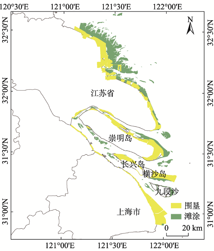
长江三角洲位于长江入海口,处于海洋、陆地和河流三大生态系统的交汇地带,是全球五十大生态敏感区之一。同时,长江河口滩涂也是世界上最大的河口冲积滩涂湿地之一。长江河口是一个丰水、多沙、中等潮汐强度的分汊河口,受径潮流的相互作用呈“三级分汊、四口入海”的态势(图1):崇明岛将长江河口分为南支和北支,南支又被长兴岛、横沙岛分为南港和北港,九段沙又将南港分为南槽和北槽。长江携带的巨量泥沙孕育了河口丰富的滩涂湿地,为长江三角洲区域提供了大量的土地资源和重要的生态屏障。
图1 研究区位置、2017年围垦、滩涂空间分布
Fig. 1 Location map of study area with reclamation zone and tidal flats distribution in 2017
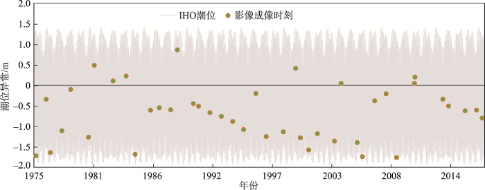
本文以Landsat MSS/ TM/ ETM+/OLI遥感影像作为数据源,并筛选出1975年以来每年潮位最低、无云或少云的影像,共计41景(表1),大部分影像的潮位都位于平均潮位以下(图2,见第273页)。所有影像都进行了大气校正,并利用ERDAS软件对部分几何精度较差的数据进行几何校正,确保总体误差小于0.5个像元。
表1 选用的Landsat影像数据
Tab. 1 Landsat images used for this study
| 编号 | 卫星 | 传感器 | 成像日期 | 成像时刻 |
|---|---|---|---|---|
| 1 | Landsat 2 | MSS | 1975-12-20 | 09:44:45 |
| 2 | Landsat 2 | MSS | 1976-11-26 | 09:35:23 |
| 3 | Landsat 2 | MSS | 1977-04-19 | 09:29:13 |
| 4 | Landsat 3 | MSS | 1978-05-11 | 09:46:21 |
| 5 | Landsat 2 | MSS | 1979-03-04 | 09:36:02 |
| 6 | Landsat 3 | MSS | 1980-10-27 | 09:33:50 |
| 7 | Landsat 3 | MSS | 1981-05-13 | 09:40:58 |
| 8 | Landsat 4 | MSS | 1983-02-08 | 09:54:17 |
| 9 | Landsat 5 | TM | 1984-04-23 | 09:52:10 |
| 10 | Landsat 5 | TM | 1985-02-21 | 09:55:26 |
| 11 | Landsat 4 | MSS | 1986-07-26 | 09:44:13 |
| 12 | Landsat 5 | TM | 1987-05-18 | 09:48:53 |
| 13 | Landsat 5 | TM | 1988-06-05 | 09:55:31 |
| 14 | Landsat 5 | TM | 1989-01-15 | 09:55:08 |
| 15 | Landsat 5 | TM | 1990-07-13 | 09:45:07 |
| 16 | Landsat 5 | TM | 1991-01-05 | 09:44:57 |
| 17 | Landsat 5 | TM | 1992-01-24 | 09:49:16 |
| 18 | Landsat 5 | TM | 1993-02-11 | 09:46:55 |
| 19 | Landsat 5 | TM | 1994-03-02 | 09:45:49 |
| 20 | Landsat 5 | TM | 1995-03-05 | 09:35:39 |
| 21 | Landsat 5 | TM | 1996-04-24 | 09:34:50 |
| 22 | Landsat 5 | TM | 1997-04-11 | 09:52:10 |
| 23 | Landsat 5 | TM | 1998-11-08 | 10:03:58 |
| 24 | Landsat 5 | TM | 1999-12-29 | 10:00:06 |
| 25 | Landsat 5 | TM | 2000-06-06 | 10:01:10 |
| 26 | Landsat 7 | ETM+ | 2001-03-13 | 10:15:18 |
| 27 | Landsat 5 | TM | 2002-01-03 | 10:04:06 |
| 28 | Landsat 5 | TM | 2003-08-02 | 10:01:44 |
| 29 | Landsat 5 | TM | 2004-03-13 | 10:04:04 |
| 30 | Landsat 5 | TM | 2005-09-08 | 10:13:07 |
| 31 | Landsat 5 | TM | 2006-03-03 | 10:15:53 |
| 32 | Landsat 5 | TM | 2007-04-23 | 10:19:43 |
| 33 | Landsat 5 | TM | 2008-05-11 | 10:13:38 |
| 34 | Landsat 5 | TM | 2009-04-28 | 10:12:26 |
| 35 | Landsat 5 | TM | 2010-12-27 | 10:14:54 |
| 36 | Landsat 5 | TM | 2011-01-12 | 10:14:56 |
| 37 | Landsat 8 | OLI | 2013-08-13 | 10:27:00 |
| 38 | Landsat 8 | OLI | 2014-02-21 | 10:25:47 |
| 39 | Landsat 8 | OLI | 2015-09-04 | 10:24:49 |
| 40 | Landsat 8 | OLI | 2016-09-22 | 10:25:14 |
| 41 | Landsat 8 | OLI | 2017-04-02 | 10:24:34 |
图2 所选Landsat影像成像时刻对应的IHO佘山站潮位情况
Fig. 2 Tidal level of the IHO Sheshan station at the imaging time of Landsat images used in this study
长江口海岸类型以淤泥质海岸为主,该类型海岸往往生长着数量繁多的耐盐植被,其近陆侧的植被生长茂密,近海侧的植被生长则比较稀疏,形成一条耐盐植物生长变化明显的过渡带。当海水大潮来临时,潮汐作用将一些贝壳、碎石、垃圾碎片等冲击到该生长界限,不再继续前进,从而形成了一条典型的“痕迹线”,在Landsat影像上清晰可见,因此可以用作高潮线指标[21,22]。此外,还有部分已开发的淤泥质海岸,人工构筑物如围垦大堤可以作为高潮线指标。考虑到目前大范围的精确潮位校正仍存在困难,本文选择每年最低潮位影像的水边线作为滩涂的外边界,以植被线或围垦大堤作为内边界进行滩涂的提取。尽管每年的影像存在潮位差异,但长期的统计规律能够反映其演变趋势,且这种方法已被成功用于其它类似的研究当中[23,24]。
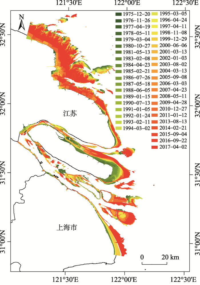
本文的研究流程主要包括遥感影像数据的获取,大气校正及几何校正,计算归一化植被指数(NDVI),利用阈值分割法或目视解译分别获取瞬时水边线、植被线或围垦大堤边界线,进而获取滩涂信息。NDVI能够通过植被在近红外波段与红光波段的反射率差异来减少岸线附近悬浮泥沙对水边线提取精度的影响[25],并提高植被与其他地物的对比度,因此基于NDVI采用阈值分割法可以较为精确地提取水边线和植被线。由于研究区范围较大,近岸水体环境存在较大差异,针对研究区不同区域选择合适的阈值可以得到更为精确的结果。最后,对获取的矢量边界参照假彩色合成影像进行目视解译修改完善。在ArcGIS中获取矢量高潮线(植被线或围垦大堤边界线)和低潮线(瞬时水边线)之后,对2个数据进行矢量相减,即可得到对应年份的滩涂矢量数据(图3,见第273页)。通过统计分析1995-2017年滩涂的时空变化,揭示长江口及重点区域滩涂的演变规律。
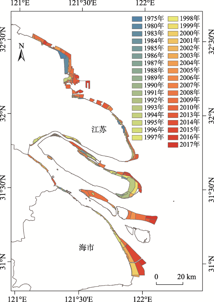
图3 1975-2017年研究区滩涂时空分布
Fig. 3 Temporal and spatial distribution of tidal flats in the study area from 1975 to 2017
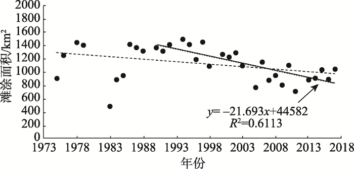
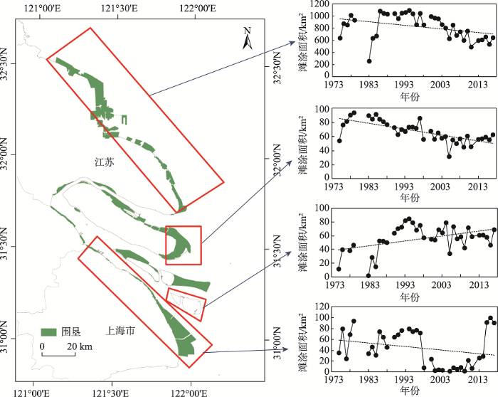
结果表明,1975年以来,研究区滩涂面积整体呈下降趋势;1990s之前滩涂面积基本保持稳定,1990s之后降低趋势较为明显,1995年前后滩涂面积达到最大值,约为1495.5 km2。1990年至今滩涂面积减少了324 km2,减少约24%,降低速率约为21.7 km2/a(图4)。其中,2017年江苏海岸(小洋口以南圆陀角以北)和长江口区域的滩涂面积分别为649.5 km2、1043.4 km2。研究区滩涂面积变化较大的区域主要位于苏北沿岸、崇明东滩及北支沿岸、长兴岛周边、横沙东滩、九段沙及南汇边滩几个区域(图3)。其中,圆陀角以北的苏北沿岸滩涂面积较大,约占研究区总滩涂面积的73%左右,在2003年和2005年甚至达到了80%。
图4 1975-2017年滩涂面积总体变化情况
Fig. 4 Total area changes of tidal flats in the study area from 1975 to 2017
苏北沿岸滩涂面积在整体上呈减少趋势,速率约为10.4 km2/a。滩涂面积在1976-1994年呈增长趋势,1994年达到最大值1101.2 km2,之后呈减少趋势(图5)。江苏区域的泥沙来源和滩涂的管理方式与长江河口区不同,并且苏北沿岸不同岸段滩涂变化存在差异,部分岸段滩涂变化比较大。1975年以来圆陀角以北的江苏海岸总共围垦了约394 km2,持续的围垦工程是沿岸滩涂演变的重要影响因素。此外,从1970年后引种的护花米草,堤外滩面的淤积加速,使得滩涂同步淤高。
图5 1975-2017年重点区域滩涂面积变化情况
Fig. 5 The areas change of tidal flats in the hotspots of the study area from 1975 to 2017
崇明东滩作为鸟类国家级自然保护区,并位于长江河口的中心位置,一直都是研究者重点关注的区域。崇明东滩岸线整体上是不断向海推进的,但其滩涂面积在整体上呈减少趋势,减少速率约为0.97 km2/a,40多年来减少了约17.9%。崇明东滩滩涂面积在1980年之前增长趋势显著,之后至2007年开始明显降低,2007年以来又呈现缓慢增加的趋势(图5)。其中,1980-2007年减少超过40 km2。
1975-2017年,九段沙滩涂面积在整体上呈增长趋势(图5)。1990s之前滩涂面积增长了约50%,但有较大的波动;1990年起,九段沙开始有植被生长,到1997年“生态引鸟工程”人工种植互花米草和芦苇,并于同期开始的深水航道建设使得九段沙植被群落扩散增速并使滩涂面积逐渐趋于稳定。1994年滩涂面积达到最大,约为85.0 km2。
南汇边滩曾经是长江河口重要的滩涂之一,1997年之前平均滩涂面积约为62.1 km2。之后,受到多次大规模围垦的影响,滩涂面积锐减,2000-2008年平均滩涂面积仅为7.6 km2(图5)。最近的围垦工程始于2008年,计划围垦149 km2。数据显示的2008年之后滩涂面积的增加是围垦促淤所产生的暂时性的滩涂,当围垦工程完成之后这些滩涂将会消失。
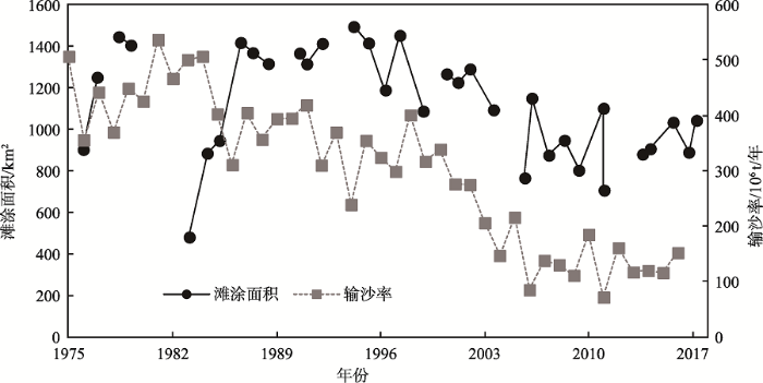
沿海滩涂是入海河流或海流携带泥沙等在入海口或海岸附近沉积形成的,其变化取决于泥沙沉积与所处水动力环境形成的“收支”关系,同时也受到人为因素的影响,而对于研究区而言人类活动已成为主要驱动力之一[26]。20世纪50年代以来,长江入海泥沙持续减少,特别是三峡大坝建成之后入海泥沙的降低趋势更为显著[27]。据不完全统计,20世纪50年代以来整个长江流域修建了五万多座大坝,包括目前世界上最大的三峡大坝[28]。大坝拦截泥沙会减少河流入海泥沙通量,进而影响到河口滩涂的演变,而大坝对径流的调节作用也可能在一定程度上对河口滩涂的演变产生影响[27,29-30]。从大通站输沙率与研究区滩涂面积时间变化的对比可发现,二者的变化趋势基本一致,尤其是2000年以来其波动趋势吻合较好(图6),因此可以推断长江入海泥沙是长江河口滩涂演变的重要影响因素之一。而长江入海泥沙的变化除了气候变化的影响之外,主要受到流域建坝、水土保持工程等人类活动的影响[31]。
图6 1975-2017年大通站输沙率与滩涂面积变化对比
Fig. 6 Comparison of the sediment discharge at Datong station and the area change of tidal flats from 1975 to 2017
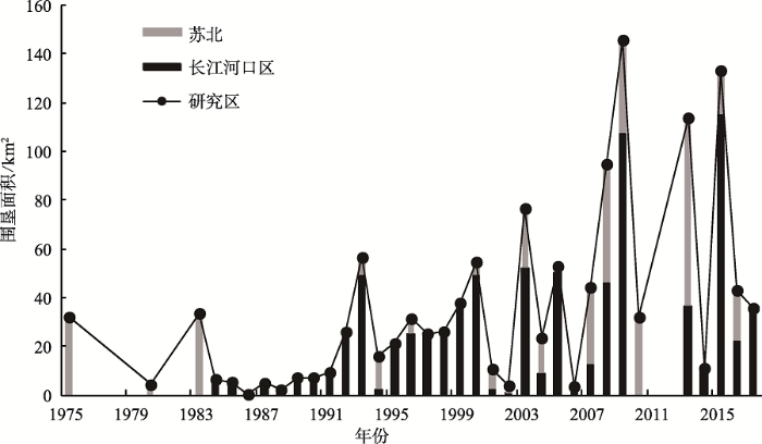
围垦、航道工程等河口人类活动也是影响长江口滩涂演变的另一个重要因素[32,33]。近年来,研究区大面积的护岸工程、围垦、水库、深水航道等开发活动总体呈增加趋势(图7)。1975年以来研究区大规模的围垦工程包括:南汇边滩为建设和扩建浦东国际机场进行的促淤围垦工程、横沙东滩的大面积促淤围垦工程、长兴岛青草沙水库工程、崇明东滩历史上多次大范围的围垦以及2013年开始为防止护花米草扩散进行的围垦工程、苏北沿岸在海岸带大开发背景下进行的围垦等(图8)。已有研究表明河口工程对长江口滩涂的演变产生了重要影响,如深水航道和南汇边滩围垦工程对九段沙的生长形态及淤涨速率均有显著影响[32],崇明东滩的围垦工程也与其滩涂的发育密切相关[27]。
图7 苏北、长江河口区及整个研究区的围垦面积变化
Fig. 7 The area changes of reclamations in the Jiangsu coast, the Yangtze River estuary zone, and the whole study area
此外,海平面变化是备受关注的全球性环境问题,它对地势低平的河口三角洲区域的影响较为显著[34]。根据国家海洋局中国海平面公报数据,长江口海平面高度呈波动增加的趋势,预计到2050年,江苏沿岸的海平面上升幅度为30~60 cm。由于海平面的上升,淤涨岸段滩面逐渐变陡,上凸形态曲率加大;侵蚀岸段滩面逐渐变缓,上凹形态趋于平直,滩面形态的变化势必对滩涂的发育产生影响[35]。预测表明,到2100年崇明东滩40%的滩涂将由于海平面上升而淹没[36]。尽管海平面变化的影响是一个长期和缓慢的过程,其对研究区滩涂演变的潜在影响仍然不能忽视。
本文选取1975年以来长江口每年潮位最低的Landsat遥感影像,利用遥感和GIS技术,通过分别获取高潮线(植被线或围垦大堤边界线)和低潮线(瞬时水边线),进而采用矢量相减的方法,获取了1975-2017年研究区滩涂数据,并对其时空演变模式和影响因素进行了分析,主要结论如下:
(1)选取每年潮位相对最低的影像获取河口滩涂数据,研究滩涂的时空演变规律具有一定的可行性,作为一种简单易行的手段可以初步解决河口区大尺度滩涂信息的提取及动态监测问题,但更精确的可操作性方法还有待进一步研究。
(2)1975-2017年,长江三角洲滩涂面积整体上呈降低趋势,但存在区域差异,20世纪90年代后降低趋势较为明显,总体降低速率约为21.7 km2/a。当前研究区滩涂主要位于苏北沿岸、崇明东滩、北支沿岸和九段沙,其中苏北沿岸滩涂面积占研究区总滩涂面积的70%以上,崇明东滩滩涂面积减少了约17.9%,九段沙滩涂面积自20世纪90年代以来基本保持稳定。
(3)流域来沙减少和围垦、深水航道等大尺度的河口工程是滩涂面积变化的主要控制因素。从长期来看,海平面上升也是影响研究区滩涂演变的一个重要的潜在因素。
The authors have declared that no competing interests exist.
| [1] |
长江口前沿潮滩对来沙锐减和海面上升的响应 [J].https://doi.org/10.3969/j.issn.1671-6647.2005.02.005 URL [本文引用: 1] 摘要
长江口前沿潮滩是上海市土地的重要来源,也是2个湿地自然保护区 所在,其冲淤演变趋势与上述命运休戚相关.根据1970年代以来的地形资料,计算了河口口门地区潮滩面积在不同时期的自然增长速率;建立了潮滩面积增长速 率同河流供沙条件之间的回归关系;探讨了河流来沙锐减和海平面上升共同作用下潮滩的冲淤趋势.结果表明:(1)近30 a大通站输沙率和含沙量分别下降26 %和31 %,而河口前沿潮滩面积增长速率下降73 %;(2)潮滩冲淤转换临界输沙率Qs和含沙量C (大通站)分别为2.6×10⁸ t/a和0.25 g/L左右; (3)由于三峡工程等的影响,长江的输沙率和含沙量将下降到上述临界值之下,加之海平面的加速上升,今后几十年研究区潮滩将遭受侵蚀.
Response of tidal bank on the changjiang river mouth foreland to drastic decline in riverine sediment supply and sea level rise [J].https://doi.org/10.3969/j.issn.1671-6647.2005.02.005 URL [本文引用: 1] 摘要
长江口前沿潮滩是上海市土地的重要来源,也是2个湿地自然保护区 所在,其冲淤演变趋势与上述命运休戚相关.根据1970年代以来的地形资料,计算了河口口门地区潮滩面积在不同时期的自然增长速率;建立了潮滩面积增长速 率同河流供沙条件之间的回归关系;探讨了河流来沙锐减和海平面上升共同作用下潮滩的冲淤趋势.结果表明:(1)近30 a大通站输沙率和含沙量分别下降26 %和31 %,而河口前沿潮滩面积增长速率下降73 %;(2)潮滩冲淤转换临界输沙率Qs和含沙量C (大通站)分别为2.6×10⁸ t/a和0.25 g/L左右; (3)由于三峡工程等的影响,长江的输沙率和含沙量将下降到上述临界值之下,加之海平面的加速上升,今后几十年研究区潮滩将遭受侵蚀.
|
| [2] |
Extracting the intertidal extent and topography of the Australian coastline from a 28 year time series of Landsat observations [J].https://doi.org/10.1016/j.rse.2017.04.009 URL [本文引用: 1] |
| [3] |
海岸带滩涂资源遥感应用研究进展 [J].
<p>海岸带滩涂环境复杂多变,进入性、通达性差。遥感技术因宏观、快速、综合、高频、动态和经济等突出优势,在海岸带滩涂资源动态监测中应用前景广阔。回顾了近年来国内外遥感技术在海岸带滩涂应用中的研究进展,主要包括海岸线提取、潮滩冲淤分析、近岸水深调查、悬浮泥沙反演以及潮滩环境监测等领域。详细论述了航空遥感、卫星光学遥感、微波以及激光等遥感技术在这些领域应用中的技术原理与方法,对近年来最新应用成果以及存在的主要问题进行了分析。指出要进一步提升遥感技术在海岸带滩涂研究领域的应用能力,需要加强开展多源数据的融合、高光谱数据的信息挖掘、微波与激光雷达数据处理等方面的研究。</p>
Advance of remote sensing application to tidal flat resource monitoring in coastal zone [J].
<p>海岸带滩涂环境复杂多变,进入性、通达性差。遥感技术因宏观、快速、综合、高频、动态和经济等突出优势,在海岸带滩涂资源动态监测中应用前景广阔。回顾了近年来国内外遥感技术在海岸带滩涂应用中的研究进展,主要包括海岸线提取、潮滩冲淤分析、近岸水深调查、悬浮泥沙反演以及潮滩环境监测等领域。详细论述了航空遥感、卫星光学遥感、微波以及激光等遥感技术在这些领域应用中的技术原理与方法,对近年来最新应用成果以及存在的主要问题进行了分析。指出要进一步提升遥感技术在海岸带滩涂研究领域的应用能力,需要加强开展多源数据的融合、高光谱数据的信息挖掘、微波与激光雷达数据处理等方面的研究。</p>
|
| [4] |
伶仃洋大铲湾潮滩冲淤遥感反演研究 [J].https://doi.org/10.3321/j.issn:0253-4193.2003.05.007 URL [本文引用: 1] 摘要
The development of beach is not convenient owing to the fact that it spreads widely and varies frequently, and routine topography data lack.The Dachan Bay of Lingdingyang estuary is taken as research area,and data resources such as MSS,TM and ETM are provided by American Landsat,the time span of these data is from 1978 to 2001,totaling 17 time span The shoreline variation of the Dachan Bay,beach zoning and its area estimating,beach utilization,and velocity of deposition are determined for the first time in China by applying waterside line elevation reverse technology based on multi-temporal satellite remote-sensing images.The gradient and the deposition velocity of the target beaches at different locations are successfully reversed.The research conclusion provides the theory foundation for the develpment of the Dachan Bay in the Shenzhen Harbor.
Deposition and erosion remote-sensing reverse of Dachan Bay beach in Lingdingyang estuary [J].https://doi.org/10.3321/j.issn:0253-4193.2003.05.007 URL [本文引用: 1] 摘要
The development of beach is not convenient owing to the fact that it spreads widely and varies frequently, and routine topography data lack.The Dachan Bay of Lingdingyang estuary is taken as research area,and data resources such as MSS,TM and ETM are provided by American Landsat,the time span of these data is from 1978 to 2001,totaling 17 time span The shoreline variation of the Dachan Bay,beach zoning and its area estimating,beach utilization,and velocity of deposition are determined for the first time in China by applying waterside line elevation reverse technology based on multi-temporal satellite remote-sensing images.The gradient and the deposition velocity of the target beaches at different locations are successfully reversed.The research conclusion provides the theory foundation for the develpment of the Dachan Bay in the Shenzhen Harbor.
|
| [5] |
一种联合光谱和纹理特征的滩涂提取技术 [J].https://doi.org/10.3969/j.issn.1671-3044.2015.05.015 URL [本文引用: 1] 摘要
提出一种联合光谱和纹理特征的支持向量机分类算法,先通过计算灰度共生矩阵得到纹理影像,然后将纹理波段与光谱波段进行叠加形成一幅多波段影像,再使用支持向量机分类算法对该影像进行分类,从而得到最终的滩涂提取结果。实验结果表明,该方法对于滩涂及周边地物具有较好的分类效果。
A joint spectral and texture features supported tidal flat extraction method [J].https://doi.org/10.3969/j.issn.1671-3044.2015.05.015 URL [本文引用: 1] 摘要
提出一种联合光谱和纹理特征的支持向量机分类算法,先通过计算灰度共生矩阵得到纹理影像,然后将纹理波段与光谱波段进行叠加形成一幅多波段影像,再使用支持向量机分类算法对该影像进行分类,从而得到最终的滩涂提取结果。实验结果表明,该方法对于滩涂及周边地物具有较好的分类效果。
|
| [6] |
基于光谱与纹理特征融合的滩涂信息提取方法 [J].https://doi.org/10.3969/j.issn.1007-6336.2008.05.002 URL [本文引用: 1] 摘要
滩涂在光学遥感影像中具有光谱信息综合的特点,单纯基于光谱特征的滩涂信息提取方法精度不高.本文在海岸带地物分类过程中,引入了纹理特征分析,发展了一种基于光谱和纹理特征融合的滩涂信息提取方法.该方法首先利用神经网络分别实现基于像元光谱特征和基于图像纹理特征的海岸带地物分类;在两种分类结果的基础上,建立融合模型,完成决策级的信息融合,从而得到最终的滩涂信息提取结果.试验结果表明,在海岸带地物分类过程中引入纹理特征分析是有效的,决策级的光谱与纹理信息融合可以使滩涂信息提取的精度达到92.3%.另外,神经网络方法用于海岸带地物分类亦是可行的.
Extracting method in tidal flat based on decision fusion of spectrum and texture [J].https://doi.org/10.3969/j.issn.1007-6336.2008.05.002 URL [本文引用: 1] 摘要
滩涂在光学遥感影像中具有光谱信息综合的特点,单纯基于光谱特征的滩涂信息提取方法精度不高.本文在海岸带地物分类过程中,引入了纹理特征分析,发展了一种基于光谱和纹理特征融合的滩涂信息提取方法.该方法首先利用神经网络分别实现基于像元光谱特征和基于图像纹理特征的海岸带地物分类;在两种分类结果的基础上,建立融合模型,完成决策级的信息融合,从而得到最终的滩涂信息提取结果.试验结果表明,在海岸带地物分类过程中引入纹理特征分析是有效的,决策级的光谱与纹理信息融合可以使滩涂信息提取的精度达到92.3%.另外,神经网络方法用于海岸带地物分类亦是可行的.
|
| [7] |
基于"资源二号"卫星和TM影像融合的滩涂信息提取 [J].https://doi.org/10.3969/j.issn.1671-6647.2004.z1.004 URL [本文引用: 1] 摘要
利用“资源二号”的全色波段和Landsat-7 ETM的多光谱波段,采用主成分变换的方法进行融合,对福建省的福清、长乐沿海的滩涂信息进行增强和提取。比较了融合影像和原始影像,表明影像中滩涂的清晰度得到了改善,大大方便了对滩涂信息的目视解译,同时也丰富了滩涂信息的色彩,提高了分类提取滩涂信息的精度和准确度,不失为滩涂信息提取的一种有效手段。
Tidal flat information extraction based on fusion of resource-2 satellite image and TM image [J].https://doi.org/10.3969/j.issn.1671-6647.2004.z1.004 URL [本文引用: 1] 摘要
利用“资源二号”的全色波段和Landsat-7 ETM的多光谱波段,采用主成分变换的方法进行融合,对福建省的福清、长乐沿海的滩涂信息进行增强和提取。比较了融合影像和原始影像,表明影像中滩涂的清晰度得到了改善,大大方便了对滩涂信息的目视解译,同时也丰富了滩涂信息的色彩,提高了分类提取滩涂信息的精度和准确度,不失为滩涂信息提取的一种有效手段。
|
| [8] |
星载高光谱Hyperion数据在海滩涂调查应用中的分析 [J].https://doi.org/10.3969/j.issn.1560-8999.2004.02.019 URL Magsci [本文引用: 1] 摘要
以江苏苏北地区为研究区,较系统地分析了目前世界上星载传感器中光谱分辨率最高的EO-1卫星Hyperion数据的基本特点和处理方法,研究了将图像的灰度值转变为辐射能量值和反射率的方法和步骤,并选取了15类典型地物,进行了样本采集、辐射亮度和反射率反演,最后对典型地物的光谱曲线进行综合分析研究,并概括了苏北沿海滩涂典型地物的基本光谱特征。
The analysis of the spectrum-reflecting characteristics of the typical objects along the beach in subei using Hyperion data [J].https://doi.org/10.3969/j.issn.1560-8999.2004.02.019 URL Magsci [本文引用: 1] 摘要
以江苏苏北地区为研究区,较系统地分析了目前世界上星载传感器中光谱分辨率最高的EO-1卫星Hyperion数据的基本特点和处理方法,研究了将图像的灰度值转变为辐射能量值和反射率的方法和步骤,并选取了15类典型地物,进行了样本采集、辐射亮度和反射率反演,最后对典型地物的光谱曲线进行综合分析研究,并概括了苏北沿海滩涂典型地物的基本光谱特征。
|
| [9] |
地理信息系统和数字高程模型在河口滩涂地形冲淤分析中的应用 [J].
采用1982年至2002年长序列长江口滩涂地形图纸资料,使用地理信息系统(GIS)进行地形图纸的数字化,建立不同时相河口滩涂地形数字高程模型(DEM),定量地提取滩涂地形的特征参数和分析滩涂地形冲淤演变规律。
Application of GIS and DEM to the analysis of deposition and erosion of foreshore in the Yangtze River estuary [J].
采用1982年至2002年长序列长江口滩涂地形图纸资料,使用地理信息系统(GIS)进行地形图纸的数字化,建立不同时相河口滩涂地形数字高程模型(DEM),定量地提取滩涂地形的特征参数和分析滩涂地形冲淤演变规律。
|
| [10] |
A simple waterline approach for tidelands using multi-temporal satellite images: A case study in the Yangtze Delta [J].https://doi.org/10.1016/j.ecss.2007.09.022 URL [本文引用: 1] 摘要
Waterline technique based on satellite remote sensing is potentially one of the most effective tools for studying changes in tidal flat environment and coastlines. However, multi-temporal waterlines obtained from satellite images are often difficult to compare directly because fluctuant tidal conditions may produce different elevation of waterlines. To overcome the difficulty, this study developed a comparable waterline solution to estimate active lateral evolutions using TM satellite images at different tide conditions. Owing to the dynamic properties, the Yangtze River mouth was selected as the case example to test the suitability of the approach, and totally four time slices were partitioned during 1987 2004 for investigating coastline changes. The first step of this technique is to digitize waterlines with various elevations labeling in a time slice. In the second step, the waterlines were merged to generate DEMs and contour maps using the linear gridding interpolation method. In the last step, any interested contour line may be extracted from DEMs and used for comparison of tideland changes. To evaluate the errors in digitizing and interpolation process, quantitative checks were examined after the DEMs were constructed. In order to monitoring the rate of coastline spread, a proposed approach for estimating mean coastline spread distance between two time spans is developed in this paper. To conclude, this work demonstrates the importance of TM/ETM images to provide high-frequency historical topography and morphodynamics information for coastal monitoring and evaluation.
|
| [11] |
淤泥质潮滩水边线提取的遥感研究及DEM构建——以长江口九段沙为例 [J].https://doi.org/10.3321/j.issn:1001-1595.2008.01.018 URL [本文引用: 1] 摘要
淤泥质潮滩通常是测绘“盲区”。本文讨论采用多时相陆地卫星提取潮滩水边线以此构建潮滩数字高程模型(DEM)的方法。探讨在不同潮情条件下,各光谱波段对淤泥质潮滩水边线判断的敏感性,分析表明沙质海岸与淤泥质海岸水边线的确定方法有较大差别。采用了GIS技术对提取的水边线赋予相应的高程值,该值采用研究区附近潮位站理论潮位推算卫星过境的瞬时潮位值,以此构建潮滩DEM,与近期实测资料进行对比:在106.2cm~358.6cm高程范围内,二者相对误差〈0.5m的区域占总面积约70%,0.5~1.0m为20%,〉1.0m占10%。遥感构建DEM作为一种手段对实测资料的欠缺是一种补充,随着遥感技术的发展精度有望提高。
A remotely sensed approach on waterline extraction of silty tidal flat for dem construction: A case study in Jiuduansha shoal of Yangtze river [J].https://doi.org/10.3321/j.issn:1001-1595.2008.01.018 URL [本文引用: 1] 摘要
淤泥质潮滩通常是测绘“盲区”。本文讨论采用多时相陆地卫星提取潮滩水边线以此构建潮滩数字高程模型(DEM)的方法。探讨在不同潮情条件下,各光谱波段对淤泥质潮滩水边线判断的敏感性,分析表明沙质海岸与淤泥质海岸水边线的确定方法有较大差别。采用了GIS技术对提取的水边线赋予相应的高程值,该值采用研究区附近潮位站理论潮位推算卫星过境的瞬时潮位值,以此构建潮滩DEM,与近期实测资料进行对比:在106.2cm~358.6cm高程范围内,二者相对误差〈0.5m的区域占总面积约70%,0.5~1.0m为20%,〉1.0m占10%。遥感构建DEM作为一种手段对实测资料的欠缺是一种补充,随着遥感技术的发展精度有望提高。
|
| [12] |
Topographic mapping on large-scale tidal flats with an iterative approach on the waterline method [J].https://doi.org/10.1016/j.ecss.2017.03.024 URL [本文引用: 1] 摘要
Tidal flats, which are both a natural ecosystem and a type of landscape, are of significant importance to ecosystem function and land resource potential. Morphologic monitoring of tidal flats has become increasingly important with respect to achieving sustainable development targets. Remote sensing is an established technique for the measurement of topography over tidal flats; of the available methods, the waterline method is particularly effective for constructing a digital elevation model (DEM) of intertidal areas. However, application of the waterline method is more limited in large-scale, shifting tidal flats areas, where the tides are not synchronized and the waterline is not a quasi-contour line. For this study, a topographical map of the intertidal regions within the Radial Sand Ridges (RSR) along the Jiangsu Coast, China, was generated using an iterative approach on the waterline method. A series of 21 multi-temporal satellite images (18 HJ-1A/B CCD and three Landsat TM/OLI) of the RSR area collected at different water levels within a five month period (31 December, 2013 28 May, 2014) was used to extract waterlines based on feature extraction techniques and artificial further modification. These 'remotely-sensed waterlines' were combined with the corresponding water levels from the 'model waterlines' simulated by a hydrodynamic model with an initial generalized DEM of exposed tidal flats. Based on the 21 heighted 'remotely-sensed waterlines', a DEM was constructed using the ANUDEM interpolation method. Using this new DEM as the input data, it was re-entered into the hydrodynamic model, and a new round of water level assignment of waterlines was performed. A third and final output DEM was generated covering an area of approximately 1900km 2 of tidal flats in the RSR. The water level simulation accuracy of the hydrodynamic model was within 0.15m based on five real-time tide stations, and the height accuracy (root mean square error) of the final DEM was 0.182m based on six transects of measured data. This study aimed at construction of an accurate DEM for a large-scale, high-variable zone within a short timespan based on an iterative way of the waterline method.
|
| [13] |
Continental scale mapping of Tidal Flats across east Asia using the Landsat archive [J].https://doi.org/10.3390/rs4113417 URL [本文引用: 1] |
| [14] |
基于潮位校正的盐城滨海潮间带遥感监测及变化分析 [J].https://doi.org/10.3969/j.issn.0253-4193.2017.05.014 URL [本文引用: 1] 摘要
潮间带是重要的滨海湿地类型之一,在生物多样性保护、全球环境变化等方面具有不可估量的价值.遥感技术已经成为滨海湿地监测的重要手段.针对潮间带遥感监测中存在时相限制的瓶颈问题,本文结合卫星过境时潮位信息,通过建立GIS模型,将利用遥感方法提取出的瞬时水边线校正至平均高、低潮线,改进了通过遥感数据恢复潮间带高程和范围的方法.在此基础上,利用1995年、2000年、2005年、2010年和2015年的多期Landsat TM以及OLI遥感数据,对盐城滨海潮间带进行了遥感监测和分析.结果表明:(1)2015年江苏盐城潮间带面积为809.27 km2,相比1995年减小了47%;(2)1995年以来盐城滨海潮间带面积总体呈减小了趋势,其中1995-2000年潮间带面积减小幅度最大,约为205.67 km2;(3)潮间带主要分布在盐城滨海南部晚庄港—新开港,占全部潮间带面积的66%;同时潮间带面积的减小也主要发生在这个区域,减小的潮间带面积占减小总面积的84%;(4)潮间带范围的变化受人为和自然双重因素影响;海平面上升和滨海湿地的大量围垦,造成了潮间带的挤压效应,使得潮间带面积迅速减小,湿地围垦等人为因素起到主导作用.
Remote-sensing analysis of Yancheng intertidal zones based on tidal correction [J].https://doi.org/10.3969/j.issn.0253-4193.2017.05.014 URL [本文引用: 1] 摘要
潮间带是重要的滨海湿地类型之一,在生物多样性保护、全球环境变化等方面具有不可估量的价值.遥感技术已经成为滨海湿地监测的重要手段.针对潮间带遥感监测中存在时相限制的瓶颈问题,本文结合卫星过境时潮位信息,通过建立GIS模型,将利用遥感方法提取出的瞬时水边线校正至平均高、低潮线,改进了通过遥感数据恢复潮间带高程和范围的方法.在此基础上,利用1995年、2000年、2005年、2010年和2015年的多期Landsat TM以及OLI遥感数据,对盐城滨海潮间带进行了遥感监测和分析.结果表明:(1)2015年江苏盐城潮间带面积为809.27 km2,相比1995年减小了47%;(2)1995年以来盐城滨海潮间带面积总体呈减小了趋势,其中1995-2000年潮间带面积减小幅度最大,约为205.67 km2;(3)潮间带主要分布在盐城滨海南部晚庄港—新开港,占全部潮间带面积的66%;同时潮间带面积的减小也主要发生在这个区域,减小的潮间带面积占减小总面积的84%;(4)潮间带范围的变化受人为和自然双重因素影响;海平面上升和滨海湿地的大量围垦,造成了潮间带的挤压效应,使得潮间带面积迅速减小,湿地围垦等人为因素起到主导作用.
|
| [15] |
Land claim and loss of tidal flats in the Yangtze Estuary [J].https://doi.org/10.1038/srep24018 URL PMID: 27035525 [本文引用: 1] 摘要
Tidal flats play a critical role in supporting biodiversity and in providing ecosystem services but are rapidly disappearing because of human activities. The Yangtze Estuary is one of the world largest alluvial estuaries and is adjacent to the most developed economic zone in China. Using the Yangtze Estuary as a study region, we developed an automatic algorithm to estimate tidal flat areas based on the Land Surface Water Index and the Normalized Difference Vegetation Index. The total area of tidal flats in the Yangtze Estuary has decreased by 36% over the past three decades, including a 38% reduction in saltmarshes and a 31% reduction in barren mudflats. Meanwhile, land claim has accumulated to 1077 m2, a value that exceeds the area of the remaining tidal flats. We divided the Yangtze Estuary into Shanghai and Jiangsu areas, which differ in riverine sediment supply and tidal flat management patterns. Although land claim has accelerated in both areas, the decline in tidal flat area has been much greater in Jiangsu than in Shanghai because of abundant supplies of sediment and artificial siltation in the latter area. The results highlight the need for better coastal planning and management based on tidal flat dynamics.
|
| [16] |
长江口崇明东滩冲淤演变分析 [J].https://doi.org/10.3969/j.issn.1003-6482.2008.03.004 URL [本文引用: 1] 摘要
通过对崇明东滩水文、泥沙、地形等资料的分析,阐述1983--2003年崇明东滩冲淤演变过程。1.1983--2001年,崇明东滩淤涨延伸较快,Om以上各等高线大幅度向外扩展,沿正东向年均外移228~279m不等。潮滩面积稳定增长,3.5m以上面积增加最多,达65.2km^2,Om以上面积共增加8.4km^2。滩面淤高迅速,尤其是高潮滩,且有随高程的降低,淤高速率下降的趋势。2.2003年与2001年相比,崇明东滩Om以上面积增加4.2km^2,2.Om以上面积减少0.8km^2,3.Om以上面积年均增长率下降。3.人类活动(如围垦)对崇明东滩的演变产生重要影响。流域来沙量大幅减少对潮滩演变的影响有待于进一步研究。
The analysis of the eastern chongming tidal flat's evolution in the Yangtze river estuary [J].https://doi.org/10.3969/j.issn.1003-6482.2008.03.004 URL [本文引用: 1] 摘要
通过对崇明东滩水文、泥沙、地形等资料的分析,阐述1983--2003年崇明东滩冲淤演变过程。1.1983--2001年,崇明东滩淤涨延伸较快,Om以上各等高线大幅度向外扩展,沿正东向年均外移228~279m不等。潮滩面积稳定增长,3.5m以上面积增加最多,达65.2km^2,Om以上面积共增加8.4km^2。滩面淤高迅速,尤其是高潮滩,且有随高程的降低,淤高速率下降的趋势。2.2003年与2001年相比,崇明东滩Om以上面积增加4.2km^2,2.Om以上面积减少0.8km^2,3.Om以上面积年均增长率下降。3.人类活动(如围垦)对崇明东滩的演变产生重要影响。流域来沙量大幅减少对潮滩演变的影响有待于进一步研究。
|
| [17] |
JUNZ,李明.长江入海泥沙的变化趋势与上海滩涂资源的可持续利用 [J].Evolutional trend of the coastal wetland in Shanghai in response to decrease of sediment supply from the Changjiang River [J]. |
| [18] |
基于数字海图及遥感的近60年崇明东滩湿地演变分析 [J].https://doi.org/10.6046/gtzyyg.2013.01.23 URL Magsci [本文引用: 1] 摘要
<p>利用9幅崇明东滩湿地1951—2006年海图数据,10幅MSS,TM及ETM<sup>+</sup>卫星数据,采用水边线及等深线叠加技术,将湿地陆面及水下部分作为相互关联的整体,定性与定量相结合,综合分析崇明东滩湿地近60 a的演变。结果表明:①东滩湿地目前的演变过程已趋于稳定,在长江口河势稳定的情况下,将保持"南冲北淤、部分交替、中部淤涨"的态势;②人类活动是东滩湿地自然演变的重要驱动力,白港潮汐通道的封堵使东滩湿地成陆过程大大加快,东滩湿地0 m线较为稳定地向东部扩展,在人类逐年围垦活动的干预下,湿地面积虽然逐年增加,但潮间带结构已偏离湿地自然状态,高潮滩面积所占比重减少,且成不连续分布,海堤直接暴露于外部海洋环境中,将降低对灾害天气的防御能力。</p>
Evolution analysis of Chongming Dongtan wetland in recent 60 years based on digital nautical chart and remote sensing [J].https://doi.org/10.6046/gtzyyg.2013.01.23 URL Magsci [本文引用: 1] 摘要
<p>利用9幅崇明东滩湿地1951—2006年海图数据,10幅MSS,TM及ETM<sup>+</sup>卫星数据,采用水边线及等深线叠加技术,将湿地陆面及水下部分作为相互关联的整体,定性与定量相结合,综合分析崇明东滩湿地近60 a的演变。结果表明:①东滩湿地目前的演变过程已趋于稳定,在长江口河势稳定的情况下,将保持"南冲北淤、部分交替、中部淤涨"的态势;②人类活动是东滩湿地自然演变的重要驱动力,白港潮汐通道的封堵使东滩湿地成陆过程大大加快,东滩湿地0 m线较为稳定地向东部扩展,在人类逐年围垦活动的干预下,湿地面积虽然逐年增加,但潮间带结构已偏离湿地自然状态,高潮滩面积所占比重减少,且成不连续分布,海堤直接暴露于外部海洋环境中,将降低对灾害天气的防御能力。</p>
|
| [19] |
Evaluation of the combined threat from sea-level rise and sedimentation reduction to the coastal wetlands in the Yangtze Estuary, China [J].https://doi.org/10.1016/j.ecoleng.2014.07.058 URL [本文引用: 1] 摘要
In recent decades, the prospect of climate change, in particular sea level rise (SLR) and its impacts on low-lying coastal areas has generated worldwide attention. The coastal wetlands located in the Yangtze Estuary, with their low elevation and decreasing sediment loading, are susceptible to both SLR and anthropogenic activities. Taking the Chongming Dongtan wetlands as a study area, two scenarios of SLR were evaluated: the present trend (1980 2010) of SLR 2.6mm/yr (PSLR) and the IPCC A1F1 scenario of 5.9mm/yr (HSLR). In addition, two scenarios of sedimentation rate were adopted for the Yangtze Estuary: the current sedimentation rate (CSR) and a reduced sedimentation rate of half of the present rate (1/2CSR). The combined effects of SLR and sedimentation reduction were evaluated by projection of the combinations of these phenomena for 2025, 2050 and 2100, using a Sea Level Affecting Marshes Model (SLAMM). The results showed that the combined effects of sea-level rise, reduced sedimentation and land subsidence could result in a considerable decrease in or even complete loss of the coastal wetland habitat in the Chongming Dongtan nature reserve, particularly under the medium-term (2050) and long-term (2100) scenarios. Without proper mitigation measures, the potential decrease in and loss of habitats and ecosystem services is inevitable. Such mitigation measures should be considered in the future for securing the coastal wetland ecosystems, which include the management of sedimentation, the rehabilitation and re-creation of wetland habitat and the control and limitation of reclamation.
|
| [20] |
Variations in tidal flats of the Changjiang (Yangtze) estuary during 1950s-2010s: Future crisis and policy implication [J].https://doi.org/10.1016/j.ocecoaman.2014.05.018 URL [本文引用: 1] 摘要
Tidal flat, is a critical natural resource for coastal ecosystem and plays a tremendous role in coastal sustainable development. However, most tidal flats in the world are facing serious challenges from both natural change and anthropogenic activities. Based on the multi-year monitoring records of tidal flats in the Changjiang (Yangtze) Estuary, the temporal-spatial changes of tidal flats and possible driving factors were statistically examined. The results indicate that the increased rate of the majority of tidal flats in the Changjiang Estuary has become slow since 2000s. Tidal flats of both Hengsha and Jiuduan Shoal showed minor enlarged trends from 2004 to 2009. However, Tidal flat areas of Nanhui Shoal above 0 m had greatly decreased by 80.8% from 1958 to 2012. Even though estuarine hydraulic engineering structures can mitigate tidal flats decreased trends, the tidal flats of the Changjiang Estuary will still suffer significant losses due to the decreasing sediment flux from upstream, ground subsidence, sea level rise and recent intensive reclamation. Thereafter, the adaptive management strategies for sustainable tidal flat resources of the Changjiang Estuary are as follows: (1) Proceeding comprehensive adjustment involving watershed and estuary; (2) keeping balance between reclamation and rebirth of tidal flats; (3) coping with sea level rise; (4) scientifically promoting aggradation of tidal flats. (C) 2014 Elsevier Ltd. All rights reserved.
|
| [21] |
基于卫星遥感的长江口岸线演化分析 [J].
通过对1987、1993、1999、2006和2010年5个时相的Landsat卫星遥感数据分析,利用适合长江口岸线演变研究的遥感波段组合,获得了长江口南北两岸20多年来岸线演变的信息,结果表明,1987—2010年期间,研究区内岸线的总长度由526.7km增长到579.7km,高潮线以上陆地面积增加541.48km2,其中,以海门市的南部海岸、崇明岛北岸和东岸、浦东新区的东部岸段以及长兴岛北部和横沙岛东部岸段变化最为明显,并且它们以不同的速度向海淤进。20多年来,造成岸线变化的原因有长江输沙、港口建设和围填海工程建设。今后应密切关注长江口岸线的变化,了解其变化规律,预测其未来变化的趋势。
Coastline evolution of the Yangtze estuary upon satellite remote sensing analysis [J].
通过对1987、1993、1999、2006和2010年5个时相的Landsat卫星遥感数据分析,利用适合长江口岸线演变研究的遥感波段组合,获得了长江口南北两岸20多年来岸线演变的信息,结果表明,1987—2010年期间,研究区内岸线的总长度由526.7km增长到579.7km,高潮线以上陆地面积增加541.48km2,其中,以海门市的南部海岸、崇明岛北岸和东岸、浦东新区的东部岸段以及长兴岛北部和横沙岛东部岸段变化最为明显,并且它们以不同的速度向海淤进。20多年来,造成岸线变化的原因有长江输沙、港口建设和围填海工程建设。今后应密切关注长江口岸线的变化,了解其变化规律,预测其未来变化的趋势。
|
| [22] |
面向对象方法和多源遥感数据的杭州湾海岸线提取分析 [J].https://doi.org/10.3724/SP.J.1047.2013.00262 URL Magsci [本文引用: 1] 摘要
本文以1983-2011 年的多源遥感数据为基础, 利用GIS 空间分析和地图代数功能, 提取杭州湾海岸线, 分析了其变迁的位置、长度, 以及增加和减少的陆地面积。结果表明:受到自然和人为因素的影响, 杭州湾南北两岸的海岸线变迁规律不同。杭州湾北岸1983-1993 年共有60.2km的海岸线向陆迁移, 最大迁移距离0.6km, 减少的陆地面积共为23.5km<sup>2</sup>。1993-2011 年由于围垦和工业填海北岸向海迁移。其中,1993-2002 年最大迁移距离3.6km, 新增陆地面积42.5km<sup>2</sup>, 2002-2011 年最大迁移距离2.9km, 新增陆地面积61.0km<sup>2</sup>。由于淤积和围垦, 杭州湾南岸海岸线不断向海迁移, 1983-1993 年、1993-2002 年和2002-2011 年向海迁移最大距离分别是1.8km、2.7km和5.1km, 新增陆地面积分别为34.3km<sup>2</sup>、230.2km<sup>2</sup>及331.7km<sup>2</sup>。海岸线向海迁移的速度越来越快, 规模越来越大。研究成果对于地图制图、滨海湿地生态资源管理, 以及海岸线保护具有十分重要的意义。
Coastline changes in Hangzhou Bay based on object-oriented method using multi-source remote sensing data [J].https://doi.org/10.3724/SP.J.1047.2013.00262 URL Magsci [本文引用: 1] 摘要
本文以1983-2011 年的多源遥感数据为基础, 利用GIS 空间分析和地图代数功能, 提取杭州湾海岸线, 分析了其变迁的位置、长度, 以及增加和减少的陆地面积。结果表明:受到自然和人为因素的影响, 杭州湾南北两岸的海岸线变迁规律不同。杭州湾北岸1983-1993 年共有60.2km的海岸线向陆迁移, 最大迁移距离0.6km, 减少的陆地面积共为23.5km<sup>2</sup>。1993-2011 年由于围垦和工业填海北岸向海迁移。其中,1993-2002 年最大迁移距离3.6km, 新增陆地面积42.5km<sup>2</sup>, 2002-2011 年最大迁移距离2.9km, 新增陆地面积61.0km<sup>2</sup>。由于淤积和围垦, 杭州湾南岸海岸线不断向海迁移, 1983-1993 年、1993-2002 年和2002-2011 年向海迁移最大距离分别是1.8km、2.7km和5.1km, 新增陆地面积分别为34.3km<sup>2</sup>、230.2km<sup>2</sup>及331.7km<sup>2</sup>。海岸线向海迁移的速度越来越快, 规模越来越大。研究成果对于地图制图、滨海湿地生态资源管理, 以及海岸线保护具有十分重要的意义。
|
| [23] |
Remote sensing of River Delta Inundation: Exploiting the potential of coarse spatial resolution, temporally-dense MODIS time series [J].https://doi.org/10.3390/rs70708516 URL [本文引用: 1] 摘要
River deltas belong to the most densely settled places on earth. Although they only account for 5% of the global land surface, over 550 million people live in deltas. These preferred livelihood locations, which feature flat terrain, fertile alluvial soils, access to fluvial and marine resources, a rich wetland biodiversity and other advantages are, however, threatened by numerous internal and external processes. Socio-economic development, urbanization, climate change induced sea level rise, as well as flood pulse changes due to upstream water diversion all lead to changes in these highly dynamic systems. A thorough understanding of a river delta general setting and intra-annual as well as long-term dynamic is therefore crucial for an informed management of natural resources. Here, remote sensing can play a key role in analyzing and monitoring these vast areas at a global scale. The goal of this study is to demonstrate the potential of intra-annual time series analyses at dense temporal, but coarse spatial resolution for inundation characterization in five river deltas located in four different countries. Based on 250 m MODIS reflectance data we analyze inundation dynamics in four densely populated Asian river deltas amely the Yellow River Delta (China), the Mekong Delta (Vietnam), the Irrawaddy Delta (Myanmar), and the Ganges-Brahmaputra (Bangladesh, India) s well as one very contrasting delta: the nearly uninhabited polar Mackenzie Delta Region in northwestern Canada for the complete time span of one year (2013). A complex processing chain of water surface derivation on a daily basis allows the generation of intra-annual time series, which indicate inundation duration in each of the deltas. Our analyses depict distinct inundation patterns within each of the deltas, which can be attributed to processes such as overland flooding, irrigation agriculture, aquaculture, or snowmelt and thermokarst processes. Clear differences between mid-latitude, subtropical, and polar deltas are illustrated, and the advantages and limitations of the approach for inundation derivation are discussed.
|
| [24] |
Spatiotemporal shoreline dynamics of Namibian coastal lagoons derived by a dense remote sensing time series approach [J].https://doi.org/10.1016/j.jag.2018.01.009 URL [本文引用: 1] 摘要
This paper proposes the remote sensing time series approach WLMO (Water-Land MOnitor) to monitor spatiotemporal shoreline changes. The approach uses a hierarchical classification system based on temporal MNDWI-trajectories with the goal to accommodate typical uncertainties in remote sensing shoreline extraction techniques such as existence of clouds and geometric mismatches between images. Applied to a dense Landsat time series between 1984 and 2014 for the two Namibian coastal lagoons at Walvis Bay and Sandwich Harbour the WLMO was able to identify detailed accretion and erosion progressions at the sand spits forming these lagoons. For both lagoons a northward expansion of the sand spits of up to 100062m was identified, which corresponds well with the prevailing northwards directed ocean current and wind processes that are responsible for the material transport along the shore. At Walvis Bay we could also show that in the 30 years of analysis the sand spit’s width has decreased by more than a half from 75062m in 1984–36062m in 2014. This ongoing cross-shore erosion process is a severe risk for future sand spit breaching, which would expose parts of the lagoon and the city to the open ocean. One of the major advantages of WLMO is the opportunity to analyze detailed spatiotemporal shoreline changes. Thus, it could be shown that the observed long-term accretion and erosion processes underwent great variations over time and cannot a priori be assumed as linear processes. Such detailed spatiotemporal process patterns are a prerequisite to improve the understanding of the processes forming the Namibian shorelines. Moreover, the approach has also the potential to be used in other coastal areas, because the focus on MNDWI-trajectories allows the transfer to many multispectral satellite sensors (e.g. Sentinel-2, ASTER) available worldwide.
|
| [25] |
Waterline extraction from Landsat TM data in a tidal flat : A case study in Gomso Bay, Korea [J].https://doi.org/10.1016/S0034-4257(02)00059-7 URL [本文引用: 1] 摘要
Waterline extraction is potentially one of the most effective satellite remote sensing tools for studying changes in tidal flat environment and coastlines. However, its application to the study of tidal flats has not been investigated in detail. The waterline in a tidal flat in Gomso Bay, Korea is characterized and evaluated using 27 sets of Landsat thematic mapper (TM) and Earth Observing System-Terra (EOS-Terra) Advanced Spaceborne Thermal Emission and Radiometer (ASTER) data. Ground truth data including grain size, soil moisture content, ground levelling, and waterline tracking have been obtained. The choice of spectral bands in terms of tidal conditions turned out to play a key role in locating the waterline. While the waterlines extracted from near-infrared (NIR), short-wavelength infrared (SWIR), and thermal infrared (TIR) data are commonly reliable on the flood tide, the discrepancies between different bands become large on the ebb tide. The bands TIR, NIR, and SWIR are, in that order, decreasingly effective in extracting the waterline while ebb tides are in progress. The effect of turbid water on NIR can be reduced by a ratioing of NIR and the visible band. The location of the waterline is also an important factor to consider; the discrepancy is largest on the middle tidal flat. Selection of the proper band for waterline extraction under various conditions is suggested. However, no single band can accommodate all aspects of the tidal flat environment. A schematic model associated with the spectral reflectance of the tidal flat is proposed in which the remnant water scattered on the surface after exposure is emphasized as an additional factor.
|
| [26] |
河口过程中第三驱动力的作用和响应——以长江河口为例 [J].https://doi.org/10.3321/j.issn:1002-008X.2008.09.005 URL [本文引用: 1] 摘要
人类活动对地球系统的影响,已由“局部”进入到“全球”,河口是一个复杂的自然综合体,在地球系统中能体现全球的变化,也能敏感地响应流域的自然变化和人类的作用.由于资源开发和人工控制增强,第三驱动力在长江河口过程中已经和将要发挥越来越重要的作用.因此,如何体现人与自然的和谐,河口怎样才能健康地发展,将是河口研究的重要理论和实践问题.文中以长江河口为例,探讨它的自然演变与自然适应、发展中的人工控制、自然资源的开发以及涉及河口当前的悬念问题,并就人与自然的和谐提出建议.
Effect and response of the third driving force in estuary process: An example of the Yangtze estuary [J].https://doi.org/10.3321/j.issn:1002-008X.2008.09.005 URL [本文引用: 1] 摘要
人类活动对地球系统的影响,已由“局部”进入到“全球”,河口是一个复杂的自然综合体,在地球系统中能体现全球的变化,也能敏感地响应流域的自然变化和人类的作用.由于资源开发和人工控制增强,第三驱动力在长江河口过程中已经和将要发挥越来越重要的作用.因此,如何体现人与自然的和谐,河口怎样才能健康地发展,将是河口研究的重要理论和实践问题.文中以长江河口为例,探讨它的自然演变与自然适应、发展中的人工控制、自然资源的开发以及涉及河口当前的悬念问题,并就人与自然的和谐提出建议.
|
| [27] |
Shoreline change of Chongming Dongtan and response to river sediment load: A remote sensing assessment [J].https://doi.org/10.1016/j.jhydrol.2014.02.013 URL [本文引用: 3] 摘要
Chongming Dongtan, located in the center of the Yangtze estuary, is a Ramsar Wetland of International Importance and National Nature Reserve. The dramatic decrease in river sediment load has attracted considerable scientific interest to this area, but few studies have paid attention to the shoreline dynamics. This study uses Landsat images spanning from 1987 to 2010 and an orthogonal transect method, which was previously developed by the authors, to model the spatial and temporal characteristics of shoreline change and explore its relationship to reduced river sediment load by use of regression analysis on three different spatial scales. Results show a general decrease in the average rates of shoreline change throughout the entire study period. The maximum average shoreline change rate of +115.5m/year occurred in the 1987 1990 interval and the minimum rate of +20.4m/year occurred from 2006 to 2008. Based on average rates of shoreline change, the coast of Dongtan was divided into three segments: the erosion segment, eastern accretion segment, and northern accretion segment. The temporal pattern of the northern accretion segment is almost completely opposite to that of the eastern accretion segment. The strongest-correlation transects are located on the northern side of the eastern tip of Dongtan and the next strongest transects are located on the south side. Other transects have a very low correlation. Transect 19 near the easternmost tip of Dongtan has a near zero correlation (r2=0.0045) but has the fastest accretion rate, and in general an increase in the shoreline change rate. The average rate of shoreline change and the net accretion area in Dongtan as a whole are significantly associated with sediment discharge at Datong Station (r2=0.69 and 0.75, respectively). This implies that shoreline accretion in Dongtan will probably slow down gradually, if the river sediment load continues to decrease in the future. The shoreline change rates achieved using our approach are consistent with previous studies, but the relationship with the river sediment load is different from results in a previous study on intertidal wetland based on bathymetric maps. The results and methods may be helpful in coastal management and understanding the evolution of the entire delta from the perspective of shoreline change.
|
| [28] |
50 000 dams later: Erosion of the Yangtze River and its delta [J].https://doi.org/10.1016/j.gloplacha.2010.09.006 URL [本文引用: 1] 摘要
Using 50 years of hydrologic and bathymetric data, we show that construction of ~ 50,000 dams throughout the Yangtze River watershed, particularly the 2003 closing of the Three Gorges Dam (TGD), has resulted in downstream channel erosion and coarsening of bottom sediment, and erosion of the Yangtze's subaqueous delta. The downstream channel from TGD reverted from an accretion rate of ~ 90 Mt (1Mt = 1000 000 t)/yr between the mid-1950 s and mid-1980 s to an erosion rate of ~ 60 Mt/yr after closing of the TGD. The delta front has devolved from ~ 125 Mm 3 (1 Mm 3 = 1000 000 m 3)/yr of sediment accumulation in the 1960 s and 1970 s, when river sediment load exceeded 450 Mt/yr, to perhaps 100 Mm 3/yr of erosion in recent years. As of 2007 erosion seemed to have been primarily centered at 5 8 m water depths; shallower areas remained relatively stable, perhaps in part due to sediment input from eroding deltaic islands. In the coming decades the Yangtze's sediment load will probably continue to decrease, and its middle-lower river channel and delta will continue to erode as new dams are built, and the South-to-North Water Diversion is begun.
|
| [29] |
Impact of water and sediment discharges on subaqueous delta evolution in Yangtze Estuary from 1950 to 2010 [J].https://doi.org/10.3882/j.issn.1674-2370.2014.03.008 URL [本文引用: 1] 摘要
In order to determine how the subaqueous delta evolution depends on the water and sediment processes in the Yangtze Estuary, the amounts of water and sediment discharged into the estuary were studied. The results show that, during the period from 1950 to 2010, there was no significant change in the annual water discharge, and the multi-annual mean water discharge increased in dry seasons and decreased in flood seasons. However, the annual sediment discharge and the multi-annual mean sediment discharge in flood and dry seasons took on a decreasing trend, and the intra-annual distribution of water and sediment discharges tended to be uniform. The evolution process from deposition to erosion occurred at the 10 m and 20 m isobaths of the subaqueous delta. The enhanced annual water and sediment discharges had a silting-up effect on the delta, and the effect of sediment was greater than that of water. Based on data analysis, empirical curves were built to present the relationships between the water and sediment discharges over a year or in dry and flood seasons and the erosion/deposition rates in typical regions of the subaqueous delta, whose evolution followed the pattern of silting in flood seasons and scouring in dry seasons. Notably, the Three Gorges Dam has changed the distribution processes of water and sediment discharges, and the dam's regulating and reserving functions can benefit the subaqueous delta deposition when the annual water and sediment discharges are not affected.
|
| [30] |
Impacts of the dam-orientated water-sediment regulation scheme on the lower reaches and delta of the Yellow River (Huanghe): A review [J].https://doi.org/10.1016/j.gloplacha.2017.08.005 URL [本文引用: 1] 摘要
The water-sediment regulation scheme (WSRS), beginning in 2002, was an unprecedented engineering effort to manage the Yellow River with the aims to mitigate the siltation both in the lower river channel and within the Xiaolangdi Reservoir utilizing the dam-regulated flood water. Ten years after its initial implementation, multi-disciplinary indicators allow us to offer a comprehensive review of this human intervention on a river-coastal system. The WSRS generally achieved its objective, including bed erosion in the lower reaches with increasing capacity for flood discharge and the mitigation of reservoir siltation. However, the WSRS presented unexpected disturbances on the delta and coastal system. Increasing grain size of suspended sediment and decreasing suspended sediment concentration at the river mouth resulted in a regime shift of sediment transport patterns that enhanced the disequilibrium of the delta. The WSRS induced an impulse delivery of nutrients and pollutants within a short period (~ 20 days), which together with the altered hydrological cycle, impacted the estuarine and coastal ecosystem. We expect that the sediment yield from the loess region in the future will decrease due to soil-conservation practices, and the lower channel erosion will also decrease as the riverbed armors with coarser sediment. These, in combination with uncertain water discharge concomitant with climate change, increasing water demands and delta subsidence, will put the delta and coastal ocean at high environmental risks. In the context of global change, this work depicts a scenario of human impacts in the river basin that were transferred along the hydrological pathway to the coastal system and remotely transformed the different components of coastal environment. The synthesis review of the WSRS indicates that an integrated management of the river-coast continuum is crucially important for the sustainability of the entire river-delta system. The lessons learned from the WSRS in the Yellow River provide insights to the integrated management of large rivers worldwide.
|
| [31] |
A preliminary estimate of human and natural contributions to the decline in sediment flux from the Yangtze River to the East China Sea [J].https://doi.org/10.1016/j.quaint.2007.11.018 URL [本文引用: 1] 摘要
This paper attempts to give a comprehensive explanation of the sediment discharge decrease from the Yangtze River to the East China Sea, taking into consideration its large scale and the basin wide complexity of changing human activities and precipitation. We examined various influencing factors include climate change, water and soil conservation measures, sand dredging, floodplain deposition and channel erosion, and dam construction. Correlation/regression analysis was used to examine the relations between data such as precipitation and water discharge, erosion or deposition in the river channel and sediment supply from the river basin. The sediment and water discharge of two major stations (Yichang and Datong) on the main river and 13 stations of the major tributaries were provided. The average precipitation in each tributary and its relationship with the water and sediment discharge were examined, and contributions of water and soil conservation measures, sand dredging, floodplain deposition and channel erosion, and dam construction to the sediment decrease were discussed. A quantitative estimation of the contribution of each impact factors to the sediment decline was attempted. Dam construction was the dominant factor (鈭88%) contributing to the decline in sediment influx, followed by the water and soil conservative measures (15卤5%). Climate change is responsible for a slight increase in sediment influx, approximately 3%. Floodplain deposition and channel erosion had an adverse effect, and the contribution of sand dredging was very limited.
|
| [32] |
Evolution of the Jiuduansha wetland and the impact of navigation works in the Yangtze Estuary, China [J].https://doi.org/10.1016/j.geomorph.2015.10.031 URL [本文引用: 2] 摘要
The estuarine wetlands in the Yangtze Estuary face increasing threats due to large-scale engineering projects and huge land requirements. As a Wetland National Nature Reserve and important stopover site for migratory shorebirds of the East Asian-Australasian Flyway, the Jiuduansha wetland, one of four main islands in the estuary, is of both national and international importance. Since 1998 the previously undisturbed wetland has been considerably modified by the adjacent Deep-water Navigation Channel project (DNC). In order to understand the role of the DNC for the evolution of the Jiuduansha wetland, we performed a diagnostic study from multiple perspectives, including deposition rate, area change, evolution track, geometric characteristics, and geomorphological change. By coupling GIS, geostatistics, and remote sensing techniques, this study demonstrates the impact of the DNC on the Jiuduansha wetland in a spatially explicit way. Multi-temporal bathymetric maps and Landsat images from before and after the DNC was constructed were adopted to conduct our study. We find that deposition has occurred in most parts of the wetland over the past almost 30 years, accounting for 67.3% of the total area. However, over 40% of the study area shows a decreasing trend in deposition rate. The spatial distribution of deposition-erosion patterns is closely linked to the DNC. We also find that the DNC has substantial effects on the evolution of the Jiuduansha wetland. The 0, 2, and 5 m isobaths in the Jiuduansha Shoal (JDS), as well as in the Jiangya Shoal (JYS), the Upper Shoal (US) and the Middle-Lower Shoal (MLS), show different response patterns to the DNC. Specifically, the south training jetty of the DNC has an "adsorption effect" on the JDS above the 2 m isobaths intersecting with it. As a result, the evolution track, geometric and geomorphological characteristics of the JDS were markedly altered in the short term. Our comprehensive analysis suggests that in the future, the JDS will become more elongated in both the upstream and downstream direction along the south training jetty, and that the south side of the JDS will be eroded.
|
| [33] |
30多年来人类活动对长江三角洲前缘滩涂冲淤演变的影响 [J].https://doi.org/10.11840/j.issn.1001-6392.2013.03.009 URL [本文引用: 1] 摘要
人类活动正愈来愈强烈地影响三角洲滩涂演变。近几十年长江三角洲前缘滩涂先后受到流域建坝等导致的入海泥沙 锐减和河口一系列大型工程的影响。揭示三角洲前缘滩涂演变对这些重大人类活动的响应不仅可以为该区域的海岸管理提供 支持,而且有助于加深人类活动驱动下海岸演变规律的理论认识。为了揭示30多年来长江三角洲前缘滩涂的阶段性变化, 本文根据1977年以来多个年份的长江口口门区地形测图,利用GIS 方法计算四大滩涂(崇明东滩、横沙东滩、九段沙和南 汇东滩) 面积的变化,分析阶段性变化的主要原因。结果表明:四大滩涂0 m等深线以上总面积的增长速率从1977-1983 年 时段的14.5 km2/a 下降到1983-1994 年时段的4.9 km2/a,继而回升至1994-2000 年的12.2 km2/a 和2000-2011 年的26.4 km2/ a;四大滩涂5 m等深线以上总面积的增长速率从1977-1983年的22.8 km2/a 下降到1983-1994 年的-1.4 km2/a,1994-2000 年回升到5.2 km2/a,2000-2011 年又回落至0.3 km2/a。前一阶段滩涂淤涨速率总体下降反映流域建坝等人类活动引起的入海 泥沙减少在滩涂演变中起控制作用,且水下滩涂(5 m线)的响应较之潮间带滩涂(0 m线以上)更加敏感。后一阶段0 m 以上滩涂淤涨速率的总体回升反映三角洲的一系列大型工程(特别是促淤工程) 对潮间带滩涂起到了明显的促淤效果,且这 种效果抵消并超过了流域入海泥沙通量下降的影响而居主导地位。总之,近三十年长江三角洲前缘淤涨速率的显著变化主要 归因于人类活动的影响。另一方面,四大滩涂间的冲淤变化呈现较明显的差异,反映人类活动对三角洲滩涂演变的影响是一 个复杂的问题,需要进一步研究。
Influence of human activities on the evolution of the tidal flat of Yangtze River delta front during the last 30 years [J].https://doi.org/10.11840/j.issn.1001-6392.2013.03.009 URL [本文引用: 1] 摘要
人类活动正愈来愈强烈地影响三角洲滩涂演变。近几十年长江三角洲前缘滩涂先后受到流域建坝等导致的入海泥沙 锐减和河口一系列大型工程的影响。揭示三角洲前缘滩涂演变对这些重大人类活动的响应不仅可以为该区域的海岸管理提供 支持,而且有助于加深人类活动驱动下海岸演变规律的理论认识。为了揭示30多年来长江三角洲前缘滩涂的阶段性变化, 本文根据1977年以来多个年份的长江口口门区地形测图,利用GIS 方法计算四大滩涂(崇明东滩、横沙东滩、九段沙和南 汇东滩) 面积的变化,分析阶段性变化的主要原因。结果表明:四大滩涂0 m等深线以上总面积的增长速率从1977-1983 年 时段的14.5 km2/a 下降到1983-1994 年时段的4.9 km2/a,继而回升至1994-2000 年的12.2 km2/a 和2000-2011 年的26.4 km2/ a;四大滩涂5 m等深线以上总面积的增长速率从1977-1983年的22.8 km2/a 下降到1983-1994 年的-1.4 km2/a,1994-2000 年回升到5.2 km2/a,2000-2011 年又回落至0.3 km2/a。前一阶段滩涂淤涨速率总体下降反映流域建坝等人类活动引起的入海 泥沙减少在滩涂演变中起控制作用,且水下滩涂(5 m线)的响应较之潮间带滩涂(0 m线以上)更加敏感。后一阶段0 m 以上滩涂淤涨速率的总体回升反映三角洲的一系列大型工程(特别是促淤工程) 对潮间带滩涂起到了明显的促淤效果,且这 种效果抵消并超过了流域入海泥沙通量下降的影响而居主导地位。总之,近三十年长江三角洲前缘淤涨速率的显著变化主要 归因于人类活动的影响。另一方面,四大滩涂间的冲淤变化呈现较明显的差异,反映人类活动对三角洲滩涂演变的影响是一 个复杂的问题,需要进一步研究。
|
| [34] |
2030年上海地区相对海平面变化趋势的研究和预测 [J].https://doi.org/10.3969/j.issn.1673-1719.2015.04.001 URL Magsci [本文引用: 1] 摘要
从全球气候变化区域响应角度,依据1912—2000年吴淞验潮站年平均潮位资料,构建灰色线性回归组合模型,并将其与最小二乘法和小波变换相结合,分析以吴淞为代表的上海绝对海平面长期变化趋势和周期变化规律。由此预测2030年上海绝对海平面相对2011年的上升值为4 cm,结合已公布的构造沉降和城市地面沉降、流域水土保持和大型水利工程及人工挖沙导致的河口河槽冲刷、河口围海造地和深水航道及跨江跨海大桥导致水位抬升等叠加效应及其变化趋势,预测2030年上海市相对海平面上升10~16 cm,陆地海平面上升有7个风险分区。
Study and prediction of the relative sea level rise in 2030 in Shanghai area [J].https://doi.org/10.3969/j.issn.1673-1719.2015.04.001 URL Magsci [本文引用: 1] 摘要
从全球气候变化区域响应角度,依据1912—2000年吴淞验潮站年平均潮位资料,构建灰色线性回归组合模型,并将其与最小二乘法和小波变换相结合,分析以吴淞为代表的上海绝对海平面长期变化趋势和周期变化规律。由此预测2030年上海绝对海平面相对2011年的上升值为4 cm,结合已公布的构造沉降和城市地面沉降、流域水土保持和大型水利工程及人工挖沙导致的河口河槽冲刷、河口围海造地和深水航道及跨江跨海大桥导致水位抬升等叠加效应及其变化趋势,预测2030年上海市相对海平面上升10~16 cm,陆地海平面上升有7个风险分区。
|
| [35] |
江苏淤泥质潮滩对海平面变化的形态响应 [J].https://doi.org/10.3321/j.issn:0375-5444.2002.01.009 URL [本文引用: 1] 摘要
中国科学院机构知识库(CAS IR GRID)以发展机构知识能力和知识管理能力为目标,快速实现对本机构知识资产的收集、长期保存、合理传播利用,积极建设对知识内容进行捕获、转化、传播、利用和审计的能力,逐步建设包括知识内容分析、关系分析和能力审计在内的知识服务能力,开展综合知识管理。
The morphological response of typical mud flat to sea level change in Jiangsu coastal plain [J].https://doi.org/10.3321/j.issn:0375-5444.2002.01.009 URL [本文引用: 1] 摘要
中国科学院机构知识库(CAS IR GRID)以发展机构知识能力和知识管理能力为目标,快速实现对本机构知识资产的收集、长期保存、合理传播利用,积极建设对知识内容进行捕获、转化、传播、利用和审计的能力,逐步建设包括知识内容分析、关系分析和能力审计在内的知识服务能力,开展综合知识管理。
|
| [36] |
Forecasting the effects of sea-level rise at Chongming Dongtan Nature Reserve in the Yangtze Delta, Shanghai, China [J].https://doi.org/10.1016/j.ecoleng.2010.06.016 URL [本文引用: 1] 摘要
Located at the mouth of the Yangtze Estuary, the Chongming Dongtan Nature Reserve is extremely vulnerable to climate change and especially to accelerated sea-level rise. We use a variety of data from remote sensing, an in situ global positioning system (GPS), tidal gauges, nautical charts, geographic spatial analysis modeling and IPCC sea-level rise scenarios to forecast the potential impacts of increased sea level on the coastal wetland habitat at Chongming Dongtan Nature Reserve. The results indicate that around 40% of the terrestrial area of the Dongtan Reserve will be inundated by the year 2100 due to an estimated 0.88 m increase in sea level. In particular, the Scirpus mariqueter communities and bare tidal flats are more vulnerable to sea-level rise. The limitations of this approach and the implication of the results for wetland and ecosystem conservation as well as management are discussed.
|

/
| 〈 |
|
〉 |