

1 引言
全球各国、各城市之间,存在着各种因物质、信息、能量等的移动或交换而形成的各种形式的“流(flow)”,将这些流嵌入地理空间形成了“地理流”。当不同类型的地理流共存时,就形成了“地理多元流”[1]。既有现实空间、物理空间的地理流,如国家或地区之间的交通流、贸易流、人口流等,也有虚拟空间、网络空间的地理流,如新闻媒体反映的积极或消极国际关系的信息流、国际论文或专利合作反映的不同地区的科研合作流等。
为了描述具有“二阶量”特性的地理流组成的复杂地理系统,可以将复杂网络特别是多层网络作为地理多元流网络化挖掘与分析的重要方法。复杂网络是网络科学在21世纪的新发展,具有不同于规则网络和随机网络的特性,如小世界特性[6]、无标度特性[7]、社区结构特性[8-9]等,相关研究主要聚焦于网络的拓扑测度、层次结构、动力演化等。复杂网络不仅是物理学和计算机科学的研究热点,同时也在生物、交通、规划等领域得到了广泛应用[10⇓-12]。多层网络是传统复杂网络模型的高维度扩展,通过层间边将不同的单层网络连接在一起形成更复杂的系统,具有严格的数学定义和丰富的测度算法[13]。若根据不同主题或时间切片对地理流网络进行分层,则可以用多层网络来刻画地理多元流网络。
社会网络是复杂网络在人文社会科学领域的应用,指个人或组织之间因为互动而形成的相对稳定的关系体系,如朋友关系、科研合作关系等[14],相关研究关注人们之间的互动和联系,以及社会互动如何影响人们的社会行为[15]。社会网络分析已经成为计算社会科学[16-17]和社会物理学[18⇓-20]等社会科学发展前沿领域的重要组成部分。空间社会网络分析是社会网络分析与空间数据分析的结合,是空间综合人文学与社会科学的重要方法。空间综合人文学与社会科学是指从地理空间的角度整合、表达多种人文信息,使得来自不同领域的学者可以使用地理空间信息技术分析和探讨人文社会科学问题,从而为单一学科难以解决的实际问题提供新的综合研究方案[21⇓-23]。一方面,地理信息科学领域的学者积极拓展研究领域,为人文学与社会科学领域的学者提供空间化、可视化的技术手段;另一方面,人文学与社会科学领域的学者积极学习和掌握地理空间信息技术,在研究中积极引入空间思维和空间可视化方法。全球尺度的地理流,如商品流、人口流、航班流等共同描绘了错综复杂的国际关系,对其进行解释需要人文社会科学知识和方法的支撑,如地缘政治[24-25]、经济贸易[26]、冲突指数计算[27]等。
空间尺度是地理空间分析的一个重要影响因素。在不同的空间尺度下,存在着不同形式的地理多元流网络,用于研究不同的问题。例如,城市尺度下,可以通过不同交通方式的地理多元流网络研究公共交通结构[32],通过不同时间切片的地理多元流网络研究城市枢纽区域的时空演化[33];国家尺度下,通过铁路客运关系、企业子母关系、百度指数关注度等构造多主题的地理多元流网络,研究城市群结构[34,35];全球尺度下,通过贸易、投资、知识等数据构造多主题的地理多元流网络研究国际关系[36]。虽然不同空间尺度的地理多元流分析存在一些共性,但是特定空间尺度的分析方法和分析内容仍有其特殊性。目前的研究中,城市尺度的研究成果非常丰富,相对较为成熟,而全球尺度则相对薄弱,有待学科交叉知识的投入和方法创新;另一方面,全球化发展带来了疾病传播、国际关系、环境治理等全球性问题,在此背景下的全球尺度地理多元流网络研究,可以挖掘出服务于全球可持续发展的重要知识,可以为制定国际关系政策、国际贸易政策等提供决策支持依据,具有非常重要的意义。因此,本文将研究的空间尺度限定为全球尺度。
政治、经济、人口和交通,是世界面临的4个重要的全球性问题,并且四者之间存在着各种复杂的相互作用和相互关联关系。综合考虑全球性问题的重要性、代表性,及数据可得性等因素,本文以这四大主题分别对应的国际关系流、国际贸易流、全球人口移动流、全球航班流组成的全球尺度地理多元流为对象展开研究。以国家、地区或城市为节点,构建包括国际关系、贸易往来、人口移动、航空交通等主题的地理多元流网络,对全球尺度地理多元流的网络化挖掘及关联分析进行研究,探索全球尺度地理多元流的研究范式,对相关研究进行综述分析,并开展一些探索性实验研究,对于发展地理多元流时空分析方法和研究全球性问题提供理论和方法参考。
后续内容包括:首先介绍了全球尺度地理多元流网络化挖掘及关联分析的研究框架;接着从地理视角和网络视角分别分析国际关系流、国际贸易流、全球航班流、以及人口移动流特别是全球尺度的人口移动流的相关研究并进行了部分示例分析;然后从关联分析视角分析地理多元流网络之间的关联关系;最后进行了总结与展望。
2 研究框架
图1
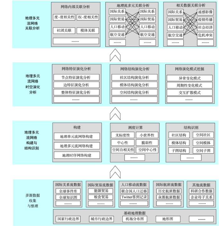
图1
全球尺度地理多元流网络化挖掘与关联分析的研究框架
Fig. 1
Research framework for networked mining and association analysis of geographical multiple flows in global scale
图1所示研究框架的具体说明如下:
(1)多源数据收集与整理
围绕“全球尺度地理多元流的网络化挖掘及关联分析”这一研究主题,收集并整理相关数据,构建实验数据集。包括:
1)基础地理数据:收集并整理多尺度(全球、洲、国家)的行政边界数据,以及城市、机场分布图等;
2)国际关系流数据:以全球事件、语言、语调数据(GDELT:Global Database of Event, Language, Tone)为主,收集并整理全球GDELT数据中的全球事件库数据、全球知识图数据。
3)国际贸易流数据:主要包括2个数据集: ① 由国际贸易中心提供的全球贸易地图数据(
4)全球人口移动流数据:主要包括2类:① 官方公开数据,其时间粒度往往较粗,如联合国发布的人口迁移数据、世界旅游组织开发的全球旅游流数据;② 研究者收集并整理的社交媒体数据,如根据Twitter和Foursquare等[37]社交媒体整理的人口迁移数据,这些数据的时间粒度较细。
5)全球航班流数据:根据OpenSky Network全球航班开源数据网站(
(2)地理多元流网络的构建与结构识别
复杂网络和多层网络理论、空间交互分析理论、地理多元流分析理论等,是构建地理多元流网络并进行测度分析与结构识别的理论基础。基于这些理论与方法进行地理多元流网络的构建与结构识别,具体包括:① 地理多元流网络构建:包括地理单元流网络构建、地理多元流网络构建、地理时序网络构建;② 地理多元流网络测度计算:研究反映网络、节点或边特性的测度指标并进行计算分析,包括无标度性、小世界性、中心性、脆弱性、空间中心性等;③ 地理多元流网络结构识别:研究网络的中观和微观结构并进行识别提取,包括社区、模体、子图,以及考虑空间效应的社区、模体、子图等。
(3)地理多元流网络的演化分析
对地理多元流网络的时序变化进行分析,可以发现其时空演变规律,从而为应用分析提供决策支持。主要研究内容包括:网络特征演化分析、网络结构演化分析、网络演化模式挖掘等。网络特征演化分析是对网络的测度或指标随时间变化的现象进行分析,包括节点特征演化分析、边特征演化分析、整体特征演化分析等;网络结构演化分析是对网络结构随时间的扩张、收缩、合并等现象进行分析,包括社区结构演化分析、模体结构演化分析、空间结构演化分析等;网络演化模式挖掘包括异常变化模式分析、周期性变化模式分析、交互扩散模式分析等。
(4)地理多元流网络的关联分析
地理多元流网络之间存在各种复杂的相互关联关系,地理多元流网络的关联分析包括:地理流网络内部的关联分析、地理流网络的多元关联分析、地理流网络与相关数据的关联分析等。地理流网络内部关联分析是对地理单元流网络内的测度与结构之间的关联关系进行分析,包括度-度相关性、权-度相关性、社团关联、模体关联等;地理流网络多元关联分析指对国际关系网络、国际贸易网络、全球人口移动网络、全球航空网络相互之间的关联关系进行分析;地理流网络与相关数据的关联分析是挖掘地理多元流网络与遥感影像、疫情传播、社会经济、危机冲突等其他相关数据之间的关联。
3 地理流的网络化挖掘与分析
采取综述分析与示例分析相结合的方式,分别探讨国际关系流、国际贸易流、全球航空交通流和全球人口移动流的网络化挖掘与分析方法。其中,国际关系流案例主要关注网络边强度分析,利用边强度解释国际关系的联系强度;贸易流案例侧重于网络度的演化,增加时序演化分析,并解释国际贸易的变化模式,该案例体现了网络时序分析的价值;全球航班流案例较为综合,既有复杂的网络测度如度分布分析、聚集系数分析,又进行了不同时间的对比,深入揭示了全球航空网络的结构特性,体现了复杂网络测度计算的价值。全球人口移动流侧重于从网络化挖掘的角度对相关研究进行梳理和分析。
3.1 国际关系流网络化挖掘与分析
国际关系是国际行为主体之间关系的总称,包括政治关系、经济关系、民族关系、军事关系、宗教关系、地域关系等。其中,国际政治关系是最重要最活跃的关系。本文中的“国际关系”主要是指国际政治关系(简称国际关系),包括国家/地区之间的合作、冲突,以及积极关系、消极关系等,可以理解为国家/地区之间的一种信息流。国际关系研究正从国家/地区间的关系研究走向日益开放和多元化的网络空间关系研究。社会网络分析已经成为国际关系研究的一种新范式[38-39]。从地理视角探究国家/地区间各种关系的地缘政治,与社会网络分析对“关系”的关注非常吻合,可以借助社会网络分析研究地缘政治环境[24,40]。国际关系具有复杂性、及时性、时空性等特点,迫切需要时空大数据分析技术为其提供新的思路和技术手段。利用社会网络分析和时空大数据分析技术进行国际关系网络化挖掘是一种有效的新思路[41⇓⇓-44]。基于大众媒体数据构建的GDELT数据为网络化视角的国际关系研究提供了丰富的数据源。GDELT数据库实时监测世界上印刷、广播、网络媒体中的新闻,并对其进行分析,提炼并记录人物、地点、组织和事件类型等关键信息。基于GDELT可开展国际关系相关的多种社会与人文研究,包括研究新闻事件的影响[45-46]、预测国际事件[47-48]、分析新闻事件与可持续发展目标之间的关系[49]等。GDELT数据已被应用于国际关系的网络化挖掘与分析中[44,50]。基于GDELT数据可以构建网络,从而分析合作或竞争的国际关系[51],或者辅助国内生产总值、消费者信心指数等社会经济指标的预测[52]。基于不同时间的事件构造时序网络,可以发现国际关系和区域模式的时空演变规律[44]。在地理流视角下,基于GDELT数据中的国际交互事件可以构建国际关系地理流网络[25,44]。本文选取2020年1月8日至14日的GDELT事件数据,根据事件参与者的国家和新闻语调,分别构造积极事件和消极事件的国际关系网络,以分析积极网络边强度排名前10的国家/地区对、消极网络边强度排名前10的国家/地区对。如图2所示,横轴表示国家/地区对构成的网络边,例如“加拿大-英国”表示加拿大和英国之间的边;纵轴表示边的强度,其值反映了国家/地区之间的积极(图2(a))或消极(图2(b))事件数。由图2可见,积极网络中强度排名前三的边是“加拿大-英国”、“英国-美国”和“加拿大-美国”,消极网络中强度排名前三的边则是“美国-伊朗”、“伊拉克-伊朗”和“伊拉克-美国”。前者可能受“2020年1月8日英国哈里王子夫妇欲定居加拿大”及其所引发的国际舆情影响,后者则可能与“2020年1月3日伊朗高级将领苏莱曼尼在伊拉克遭美军空袭身亡”及一系列相关冲突事件有关。无论积极网络还是消极网络,美国在强度排名前10的边中都多次出现,反映了美国在积极国际关系、消极国际关系中都处于相对活跃的状态。
图2

图2
国际关系积极/消极网络边强度前10国家/地区对
Fig. 2
Top 10 pairs of countries with the strongest connection in positive/negative international relationship network
3.2 国际贸易流网络化挖掘与分析
国家/地区之间的贸易往来形成了以国家/地区为节点、贸易关系(贸易额或贸易商品和服务量)为边的国际贸易流网络。国际贸易流的网络化挖掘是研究国际贸易格局的重要方法。国际贸易流网络是一个典型的复杂网络[53],即:节点度分布具有无标度性、网络具有较高的平均聚集系数和较短的平均最短路径等。复杂网络为国际贸易流的研究提供了重要的理论和方法,相关研究包括:国际贸易网络的演化研究[54]、社区结构研究[55]等。国际贸易涉及的商品和服务复杂多样、时间跨度大。对此可构造多层网络模型进行挖掘和分析[56]。可以基于贸易进出口额构建网络,也可以基于特定地区或特定商品和服务构造国际贸易流网络,如聚焦于“一带一路”国家/地区[57]或聚焦于化石能源[56]。
国际贸易中心网站(
图3

图3
“一带一路”Top5国家的出入度演化特征
Fig. 3
The evolution features of the Top5 countries networks in the Belt and Road
3.3 全球航班流网络化挖掘与分析
航空航班数据是一种典型的流数据,它按照时间顺序记载了大量且连续的的航班记录,据此可以对航空交通运输情况进行分析,广泛应用于航空流量监测、热点分析等领域。航空航班的主要数据源包括:OpenSky Network全球航班开源数据、全球众源航线数据variFlightMap、OAG历史航班数据等。这些国际航班数据包含了航司、时间、航班出发机场和到达机场等信息。将机场或机场所属的国家/地区作为网络节点,一段时间内机场或国家/地区之间的航班数量作为航空网络中边的权重,由此可以建立全球航班流网络。
本部分以OAG数据为例进行实验研究和分析。首先对数据进行清洗,完成机场三字码与国家/地区间的映射,并建立全球航班流网络。聚合一个月的航班数据为一个网络,以新冠疫情为背景,选择2019年3月、2020年3月和2021年3月的网络进行对比分析,对网络的基本测度指标进行统计。如图4所示,NS代表节点强度、C(NS)代表节点强度至少为NS的概率,不同颜色代表不同的网络构建时间(201903表示2019年3月、202003表示2020年3月、202103表示2021年3月)。分析结果表明, 3个时间段的全球航班网络的累计概率分布模式基本相似,都能用Zipf-Mandelbrot函数进行较好的拟合,当引入平移参数ρ后,Zipf拟合曲线更加理想。这说明全球航空网络的节点强度符合幂律分布,具有无标度特征,即少数国家/地区参与了大多数的航班运输,而另外的大部分国家/地区所参与的航班运输事件很少,即使在疫情影响下,这种分布规律仍然没有改变。
图4
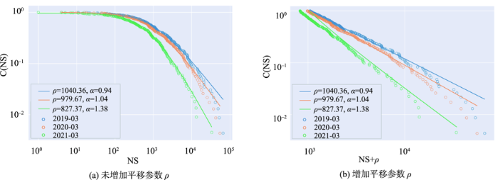
如表1所示,2019年3月和2020年3月的航空网络在节点数、连边数以及平均聚集系数等指标上变化不大,表明在疫情暴发初期,全球航班的运输总体情况较为稳定。但是,到了2021年3月,当疫情持续蔓延,尤其美国、欧洲等国家/地区的疫情没有得到有效控制,全球航班运输系统受到了较大影响,网络的节点、连边以及平均聚集系数均有较大程度的下降,并且平均最短路径变长,表明网络的连通性变差。全球航空网络的变化反映了疫情对全球交通运输造成了不利影响。
表1 2019—2021年3月全球航空网络基础测度统计
Tab. 1
| 时间 | 测度 | ||||
|---|---|---|---|---|---|
| 节点数/个 | 连边数/条 | 图密度 | 平均最短路径长度 | 平均聚集系数 | |
| 2019年3月 | 230 | 2693 | 0.102 | 2.29 | 0.642 |
| 2020年3月 | 231 | 2699 | 0.102 | 2.29 | 0.648 |
| 2021年3月 | 222 | 1994 | 0.081 | 2.36 | 0.619 |
3.4 人口移动流网络化挖掘与分析
网络化挖掘是研究宏观人口移动的重要方法,其思路是将个体的移动聚合到大尺度地理区域上,形成以地理单元为节点、地理单元之间交互关系为边的空间交互网络,通过步长分布、重力模型拟合、社区提取等方法分析其背后的地理格局[68]。相关研究更多聚焦于城市尺度,或是将社区识别结果与行政区划进行对比分析[69],或是用于识别城市影响区及其时空模式[70],在城市规划和土地利用方面具有重要应用意义。近年来,随着多层网络模型日渐成熟,逐步被用于人口移动网络建模,主要适用于 2类情况:① 使用多源数据构造多层网络[32,71-72]; ② 使用时序数据构造多层网络[33]。相比于单层网络,多层网络模型下的人口迁移网络可以描述更复杂的系统,具有更丰富的信息量。
随着全球化的发展,世界各国/地区之间的人口迁移越来越频繁,并推动着全球范围内物质、资本、信息等的加速流动和优化,全球人口迁移网络正逐步形成。全球尺度的人口移动问题得到了诸多学者的重视。全球范围内的人口移动包括永久性人口迁移和短期旅行2大类型。例如,发表于《Science》的论文《Quantifying Global International Migration Flows》利用1990—2010年的198个国家/地区每5年的人口迁移数据对全球人口移动流进行量化分析[73]。通过研究发现:自1995年以来,每5年的人口迁移量约为0.6%,最大规模的人口迁移发生在南亚与西亚、拉丁美洲到北美洲,以及非洲内部。通过全球性的人口移动可以分析全球社会的结构[74-75],研究人口迁移与各国/地区之间的经济联系[31,76]等。旅游是典型的短期人口移动类型。根据世界各国/地区之间的游客旅行情况可以构造以国家/地区为节点,以国家/地区之间的旅游流为边(权重根据游客量确定)的全球旅游流网络。通过研究发现全球旅游流网络具有非常明显的无标度特性[77]。特别是在新冠疫情期间,全球性的人口短期旅行与疫情传播之间具有密切的联系。为了阻断疫情的传播链,一些国家/地区纷纷采取了航班停运等策略,通过减少人员的国际旅行以减缓疫情传播[78-79]。
通过对全球人口移动流的网络化挖掘与分析,可以探索全球范围内的人口移动规律,从而为全球人口问题及可持续发展研究提供参考和依据,并进一步与国际关系、国际贸易等进行关联分析,研究全球尺度的政治、经济、人口和交通之间的相互影响与联系,从而为促进全球范围的可持续发展提供基础。
4 地理多元流网络的关联分析
世界是一个网络,且是相互关联的。“万物皆有联”是大数据时代的核心思维。关联分析是大数据时代的核心分析方法,也是大数据分析的魅力之所在。通过关联分析,可将一些看似毫无联系的因素联系起来,从而发现潜在的、未知的具有重要意义的规律。关联分析包括相关性、频繁性和因果性等[81]。
国际关系对人口移动具有重要影响。例如,国际关系的好坏对国际难民的流动具有重要影响。在对国际难民流进行研究的过程中,使用多元回归二次分配模型分析国际难民流与国家/地区之间友好关系程度的关联关系,反映出二者具有比较显著的依赖性[87]。
国际关系流、国际贸易流、全球航班流、全球人口移动流之间存在着各种复杂的关联关系(图5)。图5(a)反映了4个流之间的关联和叠加。国家之间的冲突、合作、积极和消极关系等,对国际贸易有着重要影响,国际政治关系网络与国际贸易网络相互作用构成了国际政治关系与国际贸易的关联关系;国际关系网络与全球人口移动网络相互作用形成了国际关系与人口移动问题;全球人口移动网络与全球航班网络相互作用,形成了人口移动与航班变化的关系研究。图5(b)对国际关系流、国际贸易流、全球人口移动流、全球航班流两两之间的关系进行了示例分析。例如,航班流和人口移动流都可以反映国家间的人员流通,但航班流具有细时间粒度的展示能力,人口移动流尤其是移民流侧重于长时间跨度,二者相结合可完整地刻画国际交互模式;GDELT新闻事件流和贸易流都可反映国家间的合作关系,但前者是虚拟空间的信息流,后者是现实空间的物质流,二者可相互佐证、相互影响,将它们结合在一起分析可更全面地认识复杂的国际关系格局。
图5
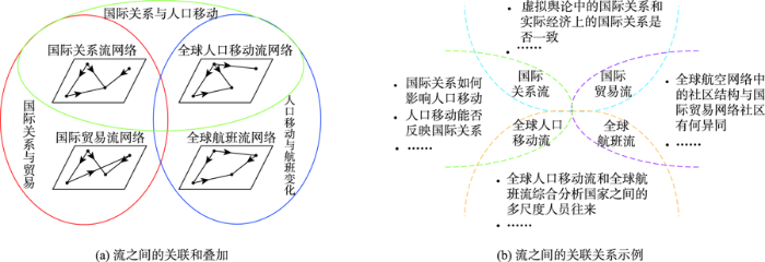
图5
地理多元流网络关联分析示意图
Fig. 5
Association analysis of geographical multiple flow networks
关联分析是大数据时代的魅力所在,如何在纷繁复杂的地理多元流网络中,深入分析和挖掘各种因素(政治、经济、交通、人口等社会人文因素,以及气候、环境等自然因素)之间错综复杂的相互关联关系,从而为全球性问题的研究和解决提供相应支持是未来发展的方向和面临的挑战。
5 结论与展望
世界是一个网络,并且是相互关联的。全球化时代的人口移动、疾病传播、国际关系、全球治理等全球性问题具有全球性、综合性和挑战性等特点,迫切需要从地理和网络视角分析全球性问题相关要素之间错综复杂的相互关系、时空格局和时空演化规律。本文提出了全球尺度地理多元流网络化挖掘及关联分析的研究框架,并从地理与网络视角综述分析了国际关系流、国际贸易流、全球航班流、全球人口移动流的网络化挖掘与分析的研究及示例,并进一步从关联分析视角初步探索了国际关系流、国际贸易流、全球航班流、全球人口移动流之间的相关关系和相互影响。本文研究属于地理信息科学与社会科学跨学科交叉融合的探索性研究,既针对地理信息科学领域的关键问题“地理多元流网络化挖掘及关联分析方法”进行研究,包括地理多元流网络的测度与结构识别方法、地理多元流网络的时空演变分析方法、地理多元流网络的关联分析方法等,同时围绕全球人口移动、国际关系等全球性的跨学科难题展开探索性试验,研究国际关系、国际贸易、全球航班网络、全球人口移动等相关因素之间的相互关系与互作用机制,探索时空大数据分析方法在国际关系分析、国际贸易分析、全球航班分析、全球人口移动分析以及交叉学科领域的应用。
进一步的研究方向包括:① 从地理视角、网络视角进一步优化全球尺度地理多元流网络化挖掘及关联分析的研究框架;② 深入探索地理多元流网络化挖掘及关联分析方法,为发展基于地理流的时空大数据分析理论与方法提供基础;③ 从关联分析视角,探索国际关系网络、国际贸易网络、全球人口移动网络、全球航空航班网络之间的相互关系与互作用机制,为研究全球性的政治问题、经济问题、人口问题及交通问题等提供决策支持和参考。
参考文献
地理流的空间模式:概念与分类
[J].
DOI:10.12082/dqxxkx.2020.190736
[本文引用: 3]

地理流被定义为地理对象在不同空间位置间的流动,而地理流通常涵盖了物质、信息、资金、能量等的空间转移。位置之间各种流的出现与强化,改变了以距离衰减效应为基本规律的传统认知。因此,针对地理流的研究将有助于从新的角度理解地理格局及其形成机理。本文认为可采用2种模型对地理流进行表达:① 将地理流抽象为包含起点和终点坐标的四元组(又称地理流正交模型);② 将其抽象为包含起点坐标、流长度与流方向的模型(又称地理流极坐标模型)。在地理流表达模型的基础上,流空间可以定义为由两个二维空间通过笛卡尔积形成的四维空间。本文给出了流空间中4种距离(最大距离、加和距离、平均距离和加权距离)、不同距离下地理流的r邻域体积以及地理流密度等测度的定义。根据地理流极坐标模型中不同要素随机性的组合方式,将地理流模式分为随机、丛集、聚散、社区、并行与等长6种常见的单一模式,并梳理了不同模式的识别方法。单一模式之间的组合可以形成混合模式,而多类流数据之间可以形成多元流模式。在未来的研究中,地理流的基础统计理论、地理流模式的挖掘方法以及在实际问题中的应用将是其重要的发展方向。
The concept and classification of spatial patterns of geographical flow
[J],
大数据时代的空间交互分析方法和应用再论
[J].
DOI:10.11821/dlxb202007014
[本文引用: 1]
空间交互是理解地表人文过程的重要基础,与空间依赖一起共同体现了地理空间的独特性、关联性以及对嵌入该空间的地理分布格局的影响,具有鲜明的时空属性,因此对于地理学研究具有重要意义。大数据为空间交互研究带来了新的机遇,能够使我们在不同时空尺度感知和观察空间交互模式并对其动态演化特征进行模拟和预测,从而为揭示人类活动规律及区域空间结构提供有力支持。本文在探讨空间交互与地理空间模式关系的基础上,描述了利用地理大数据感知空间交互的方式和定量模型,介绍了空间交互分析方法的研究进展及其在空间规划与交通、公共卫生、旅游等领域的应用情况,并就一些基本问题进行了讨论,以期为大数据支持下空间交互相关研究提供指导。
Analytical methods and applications of spatial interactions in the era of big data
[J].Spatial interaction is a critical basis of understanding human processes on the land surface. Together with spatial dependence, it embodies the uniqueness and relatedness of geographical space, as well as the impact on the embedded geographical distribution patterns. Spatial interaction also has distinctive space-time attributes, and thus it is significant to geographical research. Big data bring new opportunities for the studies of spatial interaction, which enables us to sense and observe spatial interaction patterns at different spatial scales, and simulate and predict their dynamic evolution. This provides great support for the research of human activity regularities and regional spatial structures. In this article, we first demonstrated the relationship between spatial interaction and geospatial patterns, and introduced how to sense spatial interaction with big geodata. Then, we generalized the progress of relevant models and analytical methods, and introduced the corresponding applications in fields of spatial planning, urban transportation, public health and tourism. Some key issues were also discussed. We hope this review can provide guidance for the studies of spatial interaction supported by big data.
Collective dynamics of 'small-world' networks
[J].
Emergence of scaling in random networks
[J].Systems as diverse as genetic networks or the World Wide Web are best described as networks with complex topology. A common property of many large networks is that the vertex connectivities follow a scale-free power-law distribution. This feature was found to be a consequence of two generic mechanisms: (i) networks expand continuously by the addition of new vertices, and (ii) new vertices attach preferentially to sites that are already well connected. A model based on these two ingredients reproduces the observed stationary scale-free distributions, which indicates that the development of large networks is governed by robust self-organizing phenomena that go beyond the particulars of the individual systems.
Community structure in social and biological networks
[J].A number of recent studies have focused on the statistical properties of networked systems such as social networks and the Worldwide Web. Researchers have concentrated particularly on a few properties that seem to be common to many networks: the small-world property, power-law degree distributions, and network transitivity. In this article, we highlight another property that is found in many networks, the property of community structure, in which network nodes are joined together in tightly knit groups, between which there are only looser connections. We propose a method for detecting such communities, built around the idea of using centrality indices to find community boundaries. We test our method on computer-generated and real-world graphs whose community structure is already known and find that the method detects this known structure with high sensitivity and reliability. We also apply the method to two networks whose community structure is not well known--a collaboration network and a food web--and find that it detects significant and informative community divisions in both cases.
Fast unfolding of communities in large networks
[J].
Lethality and centrality in protein networks
[J].
Classes of small-world networks
[J].We study the statistical properties of a variety of diverse real-world networks. We present evidence of the occurrence of three classes of small-world networks: (a) scale-free networks, characterized by a vertex connectivity distribution that decays as a power law; (b) broad-scale networks, characterized by a connectivity distribution that has a power law regime followed by a sharp cutoff; and (c) single-scale networks, characterized by a connectivity distribution with a fast decaying tail. Moreover, we note for the classes of broad-scale and single-scale networks that there are constraints limiting the addition of new links. Our results suggest that the nature of such constraints may be the controlling factor for the emergence of different classes of networks.
复杂网络理论与城市交通系统复杂性问题的相关研究
[J].首先综述了当今关于小世界网络、无标度网络以及复杂加权网络的最新研究成果,并从城市交通系统的角度出发,指出了综合利用复杂网络理论、动态系统理论、现代控制理论及交通科学和工程等多学科的理论与方法,在探索城市交通网络的时空复杂性及其演化机理,揭示交通流的演化过程,缓解和预防交通拥堵,指导交通实践等方面,都具有重大的科学理论意义与实际应用价值,是值得深入研究与探讨的大问题。并进一步指出了一些今后关于城市交通网络复杂性问题的研究主题。
Research on problems related to complex networks and urban traffic systems
[J].
The structure and dynamics of multilayer networks
[J].
Network analysis in the social sciences
[J].Over the past decade, there has been an explosion of interest in network research across the physical and social sciences. For social scientists, the theory of networks has been a gold mine, yielding explanations for social phenomena in a wide variety of disciplines from psychology to economics. Here, we review the kinds of things that social scientists have tried to explain using social network analysis and provide a nutshell description of the basic assumptions, goals, and explanatory mechanisms prevalent in the field. We hope to contribute to a dialogue among researchers from across the physical and social sciences who share a common interest in understanding the antecedents and consequences of network phenomena.
Identifying influential and susceptible members of social networks
[J].Identifying social influence in networks is critical to understanding how behaviors spread. We present a method that uses in vivo randomized experimentation to identify influence and susceptibility in networks while avoiding the biases inherent in traditional estimates of social contagion. Estimation in a representative sample of 1.3 million Facebook users showed that younger users are more susceptible to influence than older users, men are more influential than women, women influence men more than they influence other women, and married individuals are the least susceptible to influence in the decision to adopt the product offered. Analysis of influence and susceptibility together with network structure revealed that influential individuals are less susceptible to influence than noninfluential individuals and that they cluster in the network while susceptible individuals do not, which suggests that influential people with influential friends may be instrumental in the spread of this product in the network.
Computational social science
[J].
新计算社会学:大数据时代的社会学研究
[J].
New computational sociology: Sociological studies in the era of big data
[J].
智慧社会:社会物理学与网络科学
[J].
Society: Social physics and network science
[J].
空间综合人文学与社会科学研究进展
[J].
Development on spatially integrated humanities and social science
[J].Two basic dimensions for describing the human social development and human cultural phenomena are space and time. Previous humanities research emphasizes much of the attribution of phenomena itself and time dimension because of the technologic limitation and epistemological difference. Sometimes these research ignored the space dimension or retained the attitude of excluding it. Fortunately, more and more scholars have rethought the importance of spatial coordination system and begun to use spatial thinking in their research. These scholars come from the discipline of history, philosophy, literature, economics, sociology, anthropology, archeology, geography, politics, statistics, etc. This article, based on the instructive thought of space and integrated humanities and social science research, intends to take modern geographic information science and methodology and related space technology as a platform, to tentatively discuss the spatio -temporal characteristics of multi-disciplinary humanity and social science research. Emphases are given particularly to the spatial attribute, space distribution, spatially mutual affection and space evolution rule of the economic and cultural phenomena in human society. In this article, the authors put forward the elementary thought of spatially integrated humanities and social science research which includes basic concept, research object, basic methodology and development direction and wish it can promote the discussion.
空间综合人文学与社会科学研究综述
[J].
DOI:10.12082/dqxxkx.2020.200232
[本文引用: 2]
地理信息科学与哲学、历史、文学、艺术、社会学、经济学、政治学、管理学等人文学与社会科学进行了全面的深度融合。一方面,地理信息科学领域的学者积极拓展研究领域,为人文学与社会科学领域的学者提供空间化、可视化的技术手段;另一方面,人文学与社会科学领域的学者积极学习和掌握地理信息技术,在研究中积极引入空间思维和空间可视化方法。同时,一些适用于人文学与社会科学研究者的开放平台、代码和工具不断涌现。本文在对空间综合人文学与社会科学的最新进展进行全面总结的基础上,探讨了空间人文学与社会科学研究的思路和框架,并分别对该框架各分支的研究进展进行了梳理和评述,包括:历史GIS,文学GIS,语言学GIS,GIS与哲学、人类动力学、人文地理学等;以及GIS与政治学及国际关系学,GIS与管理学、空间计量经济学、社会地理计算、空间社会网络与空间交互网络、犯罪地理学、健康地理与公共卫生学等。接着,本文对空间综合人文学与社会科学的研究方法进行了分析,包括:空间思维与空间计量、认知心理学与空间认知、空间可视化与虚拟地理分析、平台研发等。最后,对空间综合人文学与社会科学研究的关键问题和未来发展方向进行了展望。
A review of spatially integrated humanities and social sciences
[J].
从地缘关系视角解析“一带一路”的行动路径
[J].
DOI:10.11821/dlyj201801001
[本文引用: 2]
“一带一路”倡议是人类历史上最伟大的全球治理工程,开辟了政治地理学研究的新纪元,为地缘关系研究提供了大舞台。地理学是从时间、空间和自然—社会系统三个维度理解陆地表层过程的科学,对地缘关系研究具有独特的功能和作用。因此,从地理学视角研究地缘关系具有其他学科无法比拟的优势。“一带一路”是当前最具挑战的科学和政策命题,从地缘关系视角研究“一带一路”,需要加强四个方面的结合:① 在科学思维上,需要还原论与系统论思维相结合;② 在科学数据建设上,需要社会人文与自然环境数据相结合;③ 在科学问题选择上,需要社会过程、人文过程、政治过程和自然过程相结合;④ 在研究方法上,需要经验方法、实证方法、系统方法与大数据研究方法相结合。中国地理学者应兼顾政治地理学科建设、地缘关系的学科交叉研究和“一带一路”全球实践开展研究。
Undertaking research on Belt and Road Initiative from the geo-relation perspective
[J].
DOI:10.11821/dlyj201801001
[本文引用: 2]
The Belt and Road Initiative is the greatest project aimed to improve global governance in human history ever before. It opens a new era for the research of political geography, and in particular it provides great opportunities for geo-relation research. Geography is a science that explores the surface of earth from three perspectives including the time, space and nature-society system, which equips it to undertake geo-relation research with unique tools and advantages. The Belt and Road Initiative is one of the most challenging scientific and policy issues in the world. To better study the Belt and Road Initiative from the geo-relation perspective, geographers need to make combinations in the following four ways: (1) combining reductionism and system theory in scientific thoughts; (2) combining data of both human-society and nature-environment; (3) combining research questions based on social, human, political and natural processes; (4) combining research methods on empirical, positivism, systematic, and big data. Chinese Geographers need to give considerations to balance the development of political geography, multi-discipline oriented research on geo-relations and the implementation of the Belt and Road Initiative globally.
特殊事件中国际关系网络时序演化分析
[J].
DOI:10.12082/dqxxkx.2021.200366
[本文引用: 3]
21世纪以来的国际关系错综复杂、瞬息万变,给世界的经济、政治、安全、外交等带来了深刻影响。及时掌握国际关系的变化对中国外交政策制定、整体发展规划有着极为重要的意义。随着大数据时代的来临,应用大数据方法结合国际关系定量分析的工具对国际关系变化模式进行及时、有效地挖掘成为了一个重要的议题。强时效性、高信息量的新闻事件大数据蕴含能及时地反映出国际事件影响全球国际关系的信息。网络化挖掘作为一种面向大数据的信息挖掘方法,因其具象化的关系表达方式和丰富的结构分析方法组成为数据驱动的国际关系研究的重要方法。以短期国际事件为背景,对新闻事件大数据进行网络化挖掘,进行国际关系网络的时序演化分析,能够在短期国际事件造成国际关系变化的场景下,提供应对国际关系变化的解决方案参考。本文以中美贸易战为例研究特殊事件中国际关系网络的时序演化模式:基于GDELT新闻事件数据进行国际关系网络的构建,利用复杂网络方法进行信息挖掘并进行国际关系分析。首先利用该数据构建国际关系网络,然后用动态社区划分方法对其进行时序演化模式探测,最后结合点分布模式、核密度分析、空间自相关等空间分析方法对其进行空间特性分析。研究发现:① 在特殊事件发生过程中,网络社区的演化方式与发生的子事件类型具有很强的相关性;② 同一社区的节点在空间分布上一般呈现明显的聚集特征,特定区域节点加入不同社区频率高,节点网络属性值的空间高值分布随事件发生而改变;③ 网络局部特征值随子事件发生往往会发生较大变化。本文的研究为短期国际事件中的国际关系动态变化实证分析提供了一个新的视角,为国际关系研究的空间转向提供了一个新的思路,在方法层面对数据驱动的国际关系研究进行了补充,同时也为大数据的网络化挖掘提供了参考。
Sequential evolution analysis of international relations network in special events
[J].
中国与“一带一路”沿线国家的双边关系波动对贸易往来的影响——基于GDELT海量事件数据的实证分析
[J].
The effect of bilateral relations fluctuation on trade between China and the countries along the Belt and Road
[J].
基于GDELT新闻数据的冲突强度定量表达及冲突事件检测研究
[J].
DOI:10.12082/dqxxkx.2021.210172
[本文引用: 1]
全球范围内各种冲突经常发生,及时分析各种冲突关系并监测其变化,提前干预、实施人道主义救援,可以有效避免冲突的爆发与升级。冲突事件通常被各种新闻媒体及时报道,并被记录于新闻数据库中。提取新闻数据中的冲突事件信息并量化冲突强度,从而分析国家冲突强度的变化是一种可行思路。GDELT实时监测着不同来源的新闻,自动提取新闻中的事件与事件属性信息,并将事件总体划分为冲突与合作2种类型。本文以GDELT为数据源,综合考虑事件数量、事件影响性、事件关注度多个因素,针对不同空间研究尺度提出了一种利用全球冲突指数与局部冲突指数对冲突强度定量表达的方法。在全球尺度上,计算全球各国全球冲突指数衡量国家冲突强度,分析全球国家冲突强度空间分布规律。在国家尺度上,计算局部冲突指数衡量一个国家的冲突强度变化情况,并在冲突强度定量表达的基础上,研究一种基于距离的时间序列冲突检测方法检测冲突事件的发生。研究发现:① 冲突强度高的国家主要集中在非洲和中东地区,全球冲突强度在空间上存在明显的集聚现象;② 国家局部冲突指数的突增通常对应于一些冲突事件的发生,使用本文的冲突检测方法可以有效地及时检测这种突增现象,并能为冲突预警提供支持。本文的研究成果可以为国际冲突关系分析,以及国际救援组织的决策提供参考。
Quantitative expression of conflict intensity and conflict event detection based on GDELT news data
[J].
大数据关联关系度量研究综述
[J].
Review for variable association measures in big data
[J].
大数据相关分析综述
[J].
A survey on correlation analysis of big data
[J].
Transportation interventions reshaping NYC commute: the probabilistic simulation framework assessing the impacts of ridesharing and Manhattan congestion surcharge
[EB/OL].
Does human migration affect international trade? a complex-network perspective
[J].
A multilayer perspective for the analysis of urban transportation systems
[J].Public urban mobility systems are composed by several transportation modes connected together. Most studies in urban mobility and planning often ignore the multi-layer nature of transportation systems considering only aggregated versions of this complex scenario. In this work we present a model for the representation of the transportation system of an entire city as a multiplex network. Using two different perspectives, one in which each line is a layer and one in which lines of the same transportation mode are grouped together, we study the interconnected structure of 9 different cities in Europe raging from small towns to mega-cities like London and Berlin highlighting their vulnerabilities and possible improvements. Finally, for the city of Zaragoza in Spain, we also consider data about service schedule and waiting times, which allow us to create a simple yet realistic model for urban mobility able to reproduce real-world facts and to test for network improvements.
Measuring hub locations in time-evolving spatial interaction networks based on explicit spatiotemporal coupling and group centrality
[J].
多元流视角下东北城市网络特征分析
[J].
Analysis of network characteristics of northeast cities from the perspective of multi-flow
[J].
多元流空间视角下长江中游城市群网络结构特征
[J].
Network structure characteristics of middle Yangtze urban agglomeration from the perspective of multi-flow
[J].
Country centrality in the international multiplex network
[J].DOI:10.1007/s41109-019-0114-7 URL [本文引用: 1]
ODT FLOW: Extracting, analyzing, and sharing multi-source multi-scale human mobility
[J].
Network analysis for international relations
[J].DOI:10.1017/S0020818309090195 URL [本文引用: 1]
国际关系的网络分析研究简评
[J].
Network analysis of international relations
[J].
社会网络分析方法在地缘政治领域的应用
[J].
Social network analysis in geo-politics studies
[J].
Exploring inter-country connection in mass media: A case study of China
[J].
近40年中美地缘政治关系波动及背景解析
[J].
DOI:10.13249/j.cnki.sgs.2019.07.004
[本文引用: 1]
基于GDELT数据利用概率分析和自适应分形分析方法,从合作与冲突的角度分析1979年以来历届美国总统任期内中美态度的差异以及中美态度的持久性。结果分析表明:① 中美地缘政治关系经历3个时期,分别是冷战期、转变期和经贸合作期。这3个时期的特征是中美关系的战略基础历经从联合抗苏到经贸关系转变;② 美国对华的冲突态度在老布什和克林顿时期发展和提高,在小布什时期和奥巴马前期有所缓和,但是在奥巴马后期趋于严重。③ 美国对华整体态度持续性存在约4 a时间尺度,而且主要受冲突态度的影响。在当前特朗普政府时期,中美地缘政治关系的政治和经济要素已经发生重大转变,建议中美关系政策制定者和研究者要重视这种转变,寻求新思维和新途径应对进入新阶段的中美关系。
The fluctuation and background analysis of geopolitical relations between China and the United States during the last 40 years
[J].China-US relations have always been the most important part of international geopolitical relations. Discovering and analyzing of the attitude of two sides to each other from an international multilateral perspective is of great significance for understanding the internal causes of variations in China-US geopolitical relations. Due to differences in political systems, the analysis of characteristics of the China-US changes from the perspective of the presidency of the U.S. can provide a deeper knowledge of the international geopolitical tendencies. From the time series analysis of China-US relations, we can understand the evolutionary stages of China-US geopolitical relations. An in-depth analysis of the motives of China-US relations changes is of great significance for properly making international geo-strategies. Based on the GDELT data, this paper utilized probability analysis and adaptive fractal analysis methods to analyze the attitudes' differences between China and the U.S. during the US presidential terms since 1979 from the perspectives of cooperation and conflict. Moreover, the persistence of China-US attitudes since the establishment of diplomatic ties was also studied. The results show that: 1) China-US geopolitical relations have experienced three periods: the Cold War period, the transition period and the economic and trade cooperation period. The characteristics of these three periods are that the strategic basis of China-US relations has changed from a joint anti-Soviet to economic and trade relations. 2) The negative attitude of the US toward China developed and improved during the George H.W. Bush and Clinton periods. It eased during the George W. Bush era and the early Obama period, but it became more serious in the later period of Obama. 3) The overall attitude of US toward China persists for about 4 years, and is mainly influenced by negative attitudes. During the current Trump administration, the political and economic factors of China-US geopolitical relations have undergone major transitions. It is recommended that policy-makers and researchers of China-US relations should pay attention to this transformation and seek new thoughts and new pathways to cope with China-US relations in a new stage.
GDELT:感知全球社会动态的事件大数据
[J].
DOI:10.3969/j.issn.1004-9479.2020.01.2019800
[本文引用: 1]
正确解析国家间政治关系及其演化过程是开展地缘关系研究的重要基础。从大数据的角度开展地缘关系研究为该领域的探索提供了一种新的途径。国家或区域的局部政治倾向数据无法为地缘关系研究提供全面和翔实的数据支撑。论文介绍的一个全新的事件数据库GDELT(Global Database of Event, Language, Tone),它在诸多方面弥补了传统数据的不足。该数据不仅详细记录了全球范围事件的发生时间、地点、内容以及参与者信息,而且系统地对事件进行分类和评分。本文从数据内容、事件评分和分类体系三方面详细介绍GDELT数据,并总结了该数据的优势和潜在研究方向,以期为我国地缘关系研究等领域提供帮助和参考。
GDELT: Big event data for sensing global social dynamics
[J].
DOI:10.3969/j.issn.1004-9479.2020.01.2019800
[本文引用: 1]
Properly analyzing the international political relations and their evolution process is an essential for geo-relationships research. Geo-relationships research from the perspective of big data provides a new approach for the exploration in this field. Data reflecting international political trends by traditional methods is unable to provide comprehensive and informative data support for regional or global research. A new event database GDELT (Global Database of Event, Language, Tone) introduced in this article has offset the deficiency of traditional data in many aspects. The data not only records the date-time, place, content and participant of events worldwide but also systematically classifies and scores events. This article introduces GDELT data in detail from three aspects of data content, event scoring, and classification system, and summarize the advantages and potential research directions of the data, intending to provide help and reference for China’s geo-relationships research and other fields.
GDELT数据网络化挖掘与国际关系分析
[J].
DOI:10.12082/dqxxkx.2019.180674
[本文引用: 4]
21世纪以来的国际关系错综复杂、瞬息万变,给世界的经济、安全、外交等带来了深刻变化。这些变化对中国的内外政策产生了重大影响。全面及时地分析国际关系及其变化特征,对于中国的经济和外交发展规划具有重要参考价值。国际关系研究具有复杂性、及时性、时空性等特点,迫切需要时空大数据分析技术为其提供新的思路和技术手段。大众媒体如报纸、广播等记录着世界上发生的各种各样的事件,蕴含着丰富的信息,相对于记录个人活动的社交媒体数据,其更加适合于对人类社会进行大规模和长时间的分析。GDELT是一个免费开放的新闻数据库,它实时监测世界上印刷、广播、网络媒体中的新闻,对其进行文本分析并提取出人物、地点、组织和事件等关键信息。本文利用复杂网络的理论和方法对GDELT进行网络化挖掘并进一步分析国家关系。首先利用该数据构建国家交互网络,然后通过网络特征统计分析国家之间的交互关系,最后探测国家冲突事件交互网络的时序变化。研究发现:① 国家交互网络具有无标度特性,网络连接在整体和局部上都呈现出不均匀性,少数国家与其他国家有大量交互,大多数国家与其他国家的交互很少;一个国家与少数国家有大量交互,而与大多数国家的交互很少。② 国家冲突事件交互网络的突然变化往往对应一些重大事件。本文的研究可以为大数据时代的国际关系探索提供一个新的视角,同时也为新闻媒体数据的分析提供参考。
Networked mining of GDELT and international relations analysis
[J].
Tracking disaster response and relief following the 2015 Nepal earthquake
[C]//
A first look at global news coverage of disasters by using the GDELT dataset
[M]//
Predicting social unrest events with hidden Markov models using GDELT
[J].
Detecting and forecasting domestic political crises: a graph-based approach
[C]//
Data describing the relationship between world news and sustainable development goals
[J].
Computational approach to detecting and predicting occupy protest events
[C]//
The underlying causal network from global dyadic events: allies and rivals in international relations
[C]//
Big data analysis of economic news: hints to forecast macroeconomic indicators
[J].
Topology of the world trade web
[J].
Structure and evolution of the world trade network
[J].
Identifying the community structure of the international-trade multi-network
[J].
Features and evolution of international fossil energy trade relationships: A weighted multilayer network analysis
[J].
“一带一路”贸易网络与全球贸易网络的拓扑关系
[J].
DOI:10.18306/dlkxjz.2017.11.003
[本文引用: 1]
共建“一带一路”倡议致力于建设开放型经济、确保自由包容性贸易。本文基于社区发现法、拓扑网络可视化等方法,对比分析“一带一路”贸易网络与全球贸易网络的拓扑关系,明确其贸易在全球的地位,以期为“一带一路”自由包容性贸易体系建设提供科学支撑。研究发现:①全球贸易网络可以识别出5个组团,其核心节点分别是中国、美国、德—荷—法—英等欧洲发达国家、俄罗斯、印度—阿联酋。②“一带一路”沿线可以识别出3个主组团及2个次组团,其中,亚欧大组团以中国为核心、俄罗斯为次核心,南亚—西亚组团以印度、阿联酋、沙特阿拉伯为核心。③在全球贸易网络中,大部分沿线国家仍被中国、俄罗斯、印度—阿联酋等核心节点所吸引,且与“一带一路”沿线的贸易联系较强;中东欧国家主要被德—荷—法—英等西欧国家核心节点所吸引,是“一带一路”低渗透国家;部分东南亚国家虽然被吸纳到以中国为核心的亚澳—南非组团,但与“一带一路”贸易联系还需加强。
Topological relationship between trade network in the Belt and Road Initiative area and global trade network
[J].Unimpeded trade is one of the priorities of cooperation in the Belt and Road Initiative proposed by China. On 15 May 2017, the Joint Communique of the Leaders Roundtable of the Belt and Road Forum for International Cooperation reaffirmed the participants' shared commitment to build an open economy and ensure free and inclusive trade. The Belt and Road Initiative (BRI) is not only China's new action to drive its open and global development, but also a platform for increasingly more countries to explore free and inclusive trade. It is therefore important to examine the topological relationship between BRI trade network and global trade network, for promoting a universal, rule-based, open, nondiscriminatory, and equitable multilateral trading system. Based on a literature review, this article first analyzes community structure and trade network based on community detection algorithm, and then estimates the topological relationship of different trade communities. The findings of this article are as follows. First, we identified five trade communities in global trade network through community detection algorithm, in which China, USA, Russia, India-UAE, and Germany-the Netherlands-France-Britain and other European developed countries are the cores of the five trade communities, respectively. Second, we identified three trade communities and two sub-communities in the BRI trade network, in which China is the core, Russia is the sub-core of the biggest trade community, and India, UAE, and Saudi Arabia are cores of the second trade community (South Asia-West Asia). Third, the topological analysis results indicate that in the global trade network, most BRI countries are attracted by the core nodes in the BRI area, such as China, Russia, India-UAE core nodes, and have strong trade contact with BRI countries. Most Central-East European countries are mainly attracted by Germany-the Netherlands-France-Britain and other European developed countries with low penetration of BRI trade. Although some Southeast Asian countries are incorporated into the Asia-Australia-South Africa community with China as the core, they still need to strengthen trade linkages with BRI countries.
The evolution of aviation network: global airport connectivity index 2006-2016
[J].
Quantifying the resilience of the US domestic aviation network during the COVID-19 pandemic
[J].
Travel time analysis in the Chinese coupled aviation and high-speed rail network
[J].
全球疫情下的中国内地航空网络对外连通性
[J].
DOI:10.7527/S1000-6893.2020.24569
[本文引用: 1]
新冠肺炎疫情给世界航空网络的连通性造成重大影响,网络的通达程度明显降低。为了研究中国内地的航空网络对外连通性在疫情影响下的变化,提出对外连通效率这一评价指标,并根据国内外疫情爆发不同阶段的特点采用不同的链路删除规则进行分析。研究结果表明:在疫情爆发前期,因许多国家对中国内地旅客采取入境限制措施,中国内地的航空网络对外连通效率与疫情前相比下降率最大达到39.8%,同等情形下,禁止入境措施对中国内地的对外连通性影响比停飞直航大将近一个数量级,而这两种限制措施造成的影响在不同国家间的横向差异性也巨大。此外,一些与中国内地不存在直航的国家如果采取限制入境措施,也会对中国内地的对外连通性产生很大影响。在疫情爆发中后期,全球的航线连接缩减并未对中国内地的航空对外连通性产生明显影响,中国国际航线间的连通替代关系大大提升了航空网络在此类极端情形下的鲁棒性。
External connectivity of China's mainland's air transport network in COVID-19 pandemic
[J].
新冠疫情对中国国际航空网络连通性的影响及空间差异
[J].
DOI:10.13284/j.cnki.rddl.003248
[本文引用: 1]
航空运输在实现各国互联互通、推动全球经济发展中发挥着重要作用。突发公共卫生事件或恶劣天气等均易对航空网络的连通性造成影响。本研究以新冠疫情为例,从全球航空网络视角探讨新冠疫情对中国国际航空网络连通性的影响及地区差异。研究结果表明:疫情期间,中国境外通航城市、国际航班、国际航线数量均大幅缩减,航空网络连通效率显著降低,但其空间格局未发生根本性变化,东亚和东南亚仍是中国对外主要联系地区,经济联系与贸易仍然起着重要作用。航线停飞对中国与中亚、西亚和大洋洲航空网络的连通性影响最大,而航班缩减对中国与东亚、中亚和东南亚航空网络的连通性影响最大。在国内,北京、上海和广州仍然是中国对外联系的枢纽城市,且其聚集度在疫情期间得到提升。
The impacts of COVID-19 on the connectivity of China's international air transport network and the spatial differences
[J].
DOI:10.13284/j.cnki.rddl.003248
[本文引用: 1]
Air transportation plays an important role in connecting countries and promoting global economic development. Recently, China’s international air transport network expanded rapidly in terms of navigable countries and cities and the number of air routes and flights. In this context, the connectivity and stability of the air transportation network attracted significant attention, which could be threaten by many factors such as public health emergencies, poor weather conditions, policies, etc. Focusing on COVID-19, this paper depicted the spatial patterns of canceled flights after the spread of the COVID-19 pandemic across Chinese cities and the impact on connected countries and cities overseas. Next, this paper investigated the impacts of public health emergencies on the connectivity of China’s international air transportation network by comparing the changes of the average shortest path and weighted average shortest path before and after the outbreak of the COVID-19 pandemic. The results could be summarized as follows. First, the spread of this pandemic has significantly impacted the connectivity of China's international air transport networks. The number of navigable cities, routes and flights has substantially reduced, as has the efficiency of China's international air transportation. However, the COVID-19 pandemic has not significantly influenced the worldwide air transport network in this period. Additionally, the degree of effect of COVID-19 on air transportation connection was various across regions. For example, the air route suspension has the greatest impact on China's aviation network connectivity with Central Asia, West Asia and Oceania, while flight reduction has the greatest impact on China's aviation network connectivity with Northeast Asia, Central Asia and Southeast Asia. Second, there are no significant differences between the spatial patterns of the connectivity of China’s international air transportation network before and after the outbreak of the COVID-19 pandemic; the connectivity between China and Northeast Asia, Southeast Asia, North America, and Europe remains better than other areas. The findings indicate that labor mobility, economic communication, and trade are vital in shaping the spatial pattern of the connectivity of China’ international air transport network. However, the flight aggregation degree for international flights has increased. The proportion of flights among the top 5 countries has increased from 58.1% to 67.2%, which is also closely related to factors such as the proximity and necessity of personnel, economy, and trade links. The international route networks in Beijing, Shanghai and Guangzhou are more reliable than other cities. Thus, following the outbreak of COVID-19, the distribution of China’s international routes and flights has been concentrated in these major cities. The proportion of international air routes increased from 28.8% to 38.9%. Moreover, the concentration of international flights increased from 46.6% to 76.4%, which is a higher concentration than international air routes. While expanding its focus on the depth and breadth of international air transport links, China should focus on strengthening the reliability of international air transportation networks to cope with the impact of various emergencies and ensure basic connectivity and stable operation of international air transportation networks.
基于位置感知设备的人类移动研究综述
[J].
A review of human mobility research based on location aware devices
[J].
大数据驱动的人类移动模式和模型研究
[J].
Towards big data-driven human mobility patterns and models
[J].
大数据时代的人类移动性研究
[J].
DOI:10.3724/SP.J.1047.2014.00665
[本文引用: 1]
人类个体/群体移动特征是多学科共同关注的研究主题。移动定位、无线通讯和移动互联网技术的快速发展使得获取大规模、长时间序列、精细时空粒度的个体移动轨迹和相互作用定量化成为可能。同时,地理信息科学、统计物理学、复杂网络科学和计算机科学等多学科交叉也为人类移动性研究的定量化提供了有力支撑。本文首先系统总结了大数据时代开展人类移动性研究的多源异构数据基础和多学科研究方法,然后将人类移动性研究归纳为面向人和面向地理空间两大方向。面向人的研究侧重探索人类移动特性的统计规律,并建立模型解释相应的动力学机制,或分析人类活动模式,并预测出行或活动;面向地理空间的研究侧重从地理视角分析人类群体在地理空间中的移动,探索宏观活动和地理空间的交互特征。围绕这两大方向,本文评述了人类移动性的研究进展和存在问题,认为人类移动性研究在数据稀疏性、数据偏斜影响与处理、多源异构数据挖掘、机器学习方法等方面依然面临挑战,对多学科研究方法的交叉与融合提出了更高要求。
Research on human mobility in big data era
[J].
Understanding individual human mobility patterns
[J].
预测人类移动行为的介入机会类模型研究进展
[J].
Research advances in intervening opportunity class models for predicting human mobility
[J].
Uncovering patterns of inter-urban trip and spatial interaction from social media check-in data
[J].DOI:10.1371/journal.pone.0086026 URL [本文引用: 1]
Detecting the regional delineation from a network of social media user interactions with spatial constraint: A case study of Shenzhen, China
[J].
Identification and analysis of urban influential regions using spatial interaction networks
[J].
The multilayer temporal network of public transport in Great Britain
[J].
Global multi-layer network of human mobility
[J].
Quantifying global international migration flows
[J].Widely available data on the number of people living outside of their country of birth do not adequately capture contemporary intensities and patterns of global migration flows. We present data on bilateral flows between 196 countries from 1990 through 2010 that provide a comprehensive view of international migration flows. Our data suggest a stable intensity of global 5-year migration flows at ~0.6% of world population since 1995. In addition, the results aid the interpretation of trends and patterns of migration flows to and from individual countries by placing them in a regional or global context. We estimate the largest movements to occur between South and West Asia, from Latin to North America, and within Africa.
Delineating geographical regions with networks of human interactions in an extensive set of countries
[J].
Geo-located Twitter as proxy for global mobility patterns
[J].Pervasive presence of location-sharing services made it possible for researchers to gain an unprecedented access to the direct records of human activity in space and time. This article analyses geo-located Twitter messages in order to uncover global patterns of human mobility. Based on a dataset of almost a billion tweets recorded in 2012, we estimate the volume of international travelers by country of residence. Mobility profiles of different nations were examined based on such characteristics as mobility rate, radius of gyration, diversity of destinations, and inflow-outflow balance. Temporal patterns disclose the universally valid seasons of increased international mobility and the particular character of international travels of different nations. Our analysis of the community structure of the Twitter mobility network reveals spatially cohesive regions that follow the regional division of the world. We validate our result using global tourism statistics and mobility models provided by other authors and argue that Twitter is exceptionally useful for understanding and quantifying global mobility patterns.
The relation between global migration and trade networks
[J].
Travel and tourism: Into a complex network
[J].
The association between international and domestic air traffic and the Coronavirus (COVID-19) outbreak
[J].The World Health Organization (WHO) has declared the current outbreak of the novel coronavirus (COVID-19) a global pandemic. Many countries are facing increasing numbers of COVID-19 cases, which are, in their origin mostly attributed to regular international flight connections with China. This study aims to investigate this relation by analyzing available data on air traffic volume and the spread of COVID-19 cases.and findings: We analyzed available data on current domestic and international passenger volume and flight routes and compared these to the distribution of domestic and international COVID-19 cases.Our data indicate a strong linear correlation between domestic COVID-19 cases and passenger volume for regions within China (r = 0.92, p = 0.19) and a significant correlation between international COVID-19 cases and passenger volume (r = 0.98, p < 0.01).The number of flight routes as well as total passenger volume are highly relevant risk factors for the spread of current COVID-19. Multiple regions within Asia, as well as some in North America and Europe are at serious risk of constant exposure to COVID-19 from China and other highly infected countries. Risk for COVID-19 exposure remains relatively low in South America and Africa. If adequate measures are taken, including on-site disease detection and temporary passenger quarantine, limited but not terminated air traffic can be a feasible option to prevent a long-term crisis. Reasonable risk calculations and case evaluations per passenger volume are crucial aspects which must be considered when reducing international flights.Copyright © 2020. Published by Elsevier B.V.
COVID-19 and international travel restrictions: the geopolitics of health and tourism
[J].
Community structure in time-dependent, multiscale, and multiplex networks
[J].Network science is an interdisciplinary endeavor, with methods and applications drawn from across the natural, social, and information sciences. A prominent problem in network science is the algorithmic detection of tightly connected groups of nodes known as communities. We developed a generalized framework of network quality functions that allowed us to study the community structure of arbitrary multislice networks, which are combinations of individual networks coupled through links that connect each node in one network slice to itself in other slices. This framework allows studies of community structure in a general setting encompassing networks that evolve over time, have multiple types of links (multiplexity), and have multiple scales.
Association, correlation and causation
[J].
Spatial cluster detection in spatial flow data
[J].
Flow Cross K-function: A bivariate flow analytical method
[J].
Identifying local spatial association in flow data
[J].
On the relation between tourism and trade: A network experiment
[C]//
The relation between migration and FDI in the OECD from a complex network perspective
[J].
How inter-state amity and animosity complement migration networks to drive refugee flows: A multi-layer network analysis
多层航线聚合网络建模及相关性分析
[J].
Multi-layer route aggregation network modeling and correlation analysis
[J].
Aviation diplomacy: A conceptual framework for analyzing the relationship between aviation and international relations
[J].DOI:10.1057/s41254-020-00172-5 URL [本文引用: 1]
Martin Kunz Memorial Lecture. Tourism benefits and aviation policy
[J].
Structural position in the world system and economic growth, 1955-1970: A multiple-network analysis of transnational interactions
[J].
Using four different online media sources to forecast the crude oil price
[J].
