王成军 , 毛政元, 徐伟铭
WANG Chengjun, MAO Zhengyuan, XU Weiming
通讯作者:
收稿日期: 2017-07-22
修回日期: 2017-09-24
网络出版日期: 2018-03-02
版权声明: 2018 《地球信息科学学报》编辑部 《地球信息科学学报》编辑部 所有
基金资助:
作者简介:
作者简介:王成军(1993-),男,江西萍乡人,硕士生,研究方向为计算机遥感图像处理,地理国情监测技术。E-mail: Wangchengjun_Giser@163.com
展开
摘要
针对高分辨率遥感影像变化检测结果较破碎,易产生椒盐噪声、监督训练过程中人工标注成本较高、训练样本冗余以及大量未标注样本信息未有效利用等问题,提出一种超像素与主动学习相结合的高分辨率遥感影像变化检测方法。利用超像素分割算法得到超像素对象,提取其光谱和纹理特征;引入并借助主动学习样本选择策略充分利用未标注样本信息,挖掘不确定性最大、最易错分的样本交由用户人工标注;为保证所选样本的多样性,加入基于余弦角距离的样本相似性度量,以减少样本间信息冗余,在减轻人工标注负担的同时获得良好的分类性能。通过对2组不同场景的遥感影像的实验,表明本文提出的2种方法能够在标注少量训练样本的情况下获得较好的变化检测结果,且加入样本相似性度量的变化检测方法在有效减少人工标注成本和训练样本冗余的同时,能够更快地达到收敛、提升检测质量。
关键词:
Abstract
In terms of change detection with high resolution remote sensing images, there are still some unresolved problems such as scattered plots with ragged boundaries in output, being prone to occurrence of “salt-and-pepper” noise, expensive cost of manual annotation in the process of supervised training, redundancy of training samples, underutilization of information in unlabeled samples and so on. In order to address these problems, this paper proposes a new high resolution remote sensing image change detection method by combining the superpixel segmentation technology and Active Learning (AL) approaches. The proposed method consists of the following steps. Firstly the difference image is derived from two temporal remote sensing images. Subsequently the lattice-like homogenous superpixel are obtained by applying the Simple Linear Iterative Clustering (SLIC) algorithm. Simultaneously, we compare the SLIC algorithm with entropy-rate-based and modified-watershed-based superpixel generating algorithms respectively by means of homogeneity of superpixel and their coherence with image object boundaries. Then we compute the means and standard deviations of three bands of superpixel objects as spectral features and extract the entropy, energy and angular second moment by employing Gray-Level Co-occurrence Matrix (GLCM) as texture features. After that, initial training samples are randomly selected and labeled by introducing and following the Margin Sampling (MS) active learning sample selection strategy which is a kind of SVM based AL algorithm taking advantage of SVM geometrical properties and suitable for bipartition problems. A cosine distance based sample similarity measurement called Angle Based Diversity (ABD) is introduced to relief redundancy and ensure diversity of the selected samples. Lastly change detection is carried out according to the extracted information from trained samples. The proposed algorithms (SLIC-MS, SLIC-MS+ABD) are utilized to process WorldViewⅡmultispectral remote sensing data of urban and suburb scenes and the detection result from proposed sampling is compared with that from random sampling to explain detection accuracy of our methods. To illustrate the efficiency of methods proposed in this article, we investigate the iterative times of three techniques for reaching the same detection accuracy. Experimental results confirm that both SLIC-MS and SLIC-MS+ABD can reduce manual labeling cost and achieve better change detection quality than random sampling methods. They also indicate that the two proposed methods can find out samples with high uncertainty, which can be labeled by user themselves, from the unlabeled sample pool by making full use of and mining unlabeled sample information. Compared with the other two methods, SLIC-MS+ABD is more accurate with respect to identical data sets (the same two mentioned remote sensing images) and the same labeled sample number because the diversity of new selected samples has been considered in the learning process. In addition, SLIC-MS+ABD can obviously reduce iterative times to converge for achieving the same detection accuracy than other two approaches. On the basis of the experiment, it can be concluded that our proposed methods greatly relief the amount of user marking and acquire good change detection performance on high resolution remote sensing data sets as well. Experimental results also indicate that the methods implemented in this article saliently exhibit their advantages of manual cost reduction in sample labeling, avoidance of training sample redundancy to reach the same change detection quality for the same data set.
Keywords:
变化检测在土地利用/覆被变化、城市扩张和灾害监测等方面发挥着重要的作用[1],它是通过观测一个对象或者现象在不同时刻的状态提取变化信息的过程[2]。近年来,一系列成功发射的高分商用卫星正在以越来越低的价格提供越来越丰富的高空间分辨率遥感影像(下文简称“高分辨率遥感影像”或“高分影像”)数据资源,为人类更加精细地检测地表变化提供新的可能性。同时,空间分辨率的提高,使高分影像的光谱异质性明显增大,过于丰富的地物细节信息、大量“同物异谱”和“同谱异物”现象以及阴影等因素的不利影响也给基于高分影像的变化检测带来了新的挑战。现有相关文献中提出了大量的变化检测方法[3,4,5],这些方法各具特色,但直接运用前人提出的方法实施高分影像变化检测中还存在以下问题:① 传统的基于像元的变化检测方法容易产生“椒盐现象”,检测结果图斑边缘破碎;② 基于对象的变化检测流程一般是通过某种分割算法将像元合并成影像对象,但现有的分割算法很难有效地提取合理表达影像空间结构信息的局部影像特征;③ 基于监督学习的变化检测方法需要选取大量的训练样本,人工标注成本较高,降低了变化检测的效率。
本文通过集成面向对象和监督学习方法的优势,提出一种超像素(Superpixel)与主动学习 (Active Learning,AL)相结合的高分辨率遥感影像变化检测方法。针对现有分割算法不能有效提取影像局部特征与合理表达影像空间结构信息的缺点,实现超像素尺度的高分辨率影像对象分割;针对监督学习变化检测方法效率低的问题,引入主动学习分类方法,提高变化检测的精度与效率。
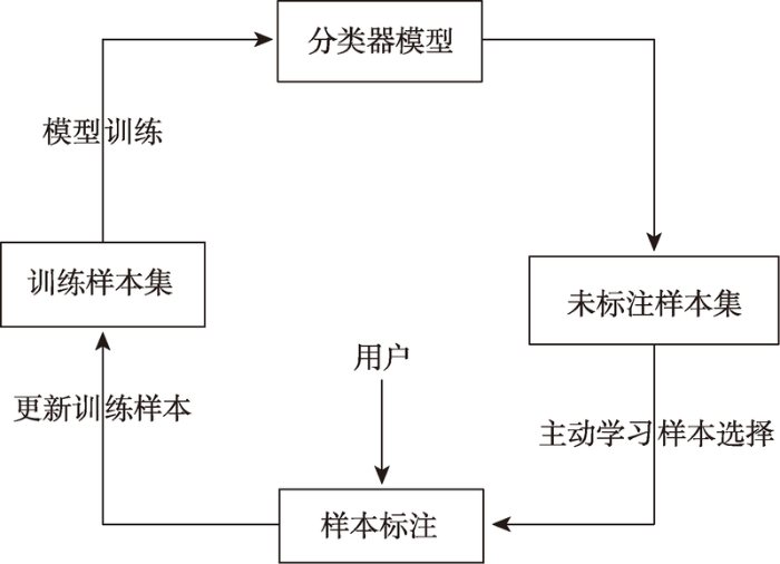
超像素分割与主动学习相结合的变化检测方法的基本思路如下:利用超像素分割算法对2个时相构造的差值影像进行分割得到一系列边缘特征较好的超像素影像对象;以超像素影像对象为基本处理单元,提取其光谱和纹理特征,选取少量样本进行标记,通过主动学习方法训练分类器获得良好的分类性能,从而在最大限度地控制标注成本的前提下,提高变化检测效率。具体算法流程如图1所示。
2003年,Ren等[4]首次提出了超像素的概念,超像素是指图像中具有局部一致性、能够保持图像局部结构特征的子区域,超像素分割就是将像素合并成超像素的过程[6]。基于图论和基于梯度上升是目前实现超像素分割的2种基本思路[7]。图割(Normalized Cuts)[8]、超像素网格(Superpixel Lattices)[9]、熵率超像素分割(Entropy Rate Superpixel Segmentation)[10]属于前者;分水岭(Watershed)[11]、Turbopixel[12]、简单线性迭代聚类(Simple Linear Iterative Clustering,SLIC)[13]属于后者。本文采用Achanta等[14,15]提出的SLIC算法获取超像素,该算法综合考虑了像素的光谱和空间特征,具有较快的运行速度、较高的存储效率以及较好的边缘信息保持度等优势。
SLIC是对K-Mean算法的改进,该算法仅需要一个参数K,表示期望得到的超像素个数。假设图像的像素为N,SLIC算法首先在
其中,
式中:m是紧致度系数,其值越大超像素越紧致,一般设为10;s为超像素大小;dc代表在CIELAB颜色空间中像素点(xi,yi)与(xi,yi)之间的颜色距离;Sp表示第p个波段;ds表示像元点(xi,yi)与(xi,yi)之间的空间距离,颜色距离控制超像素的同质性,空间距离控制超像素的紧致度[18]。
主动学习是一种利用未标注样本的学习技术,主动学习的思想是通过启发式学习策略,从样本集中选择高信息含量的样本训练得到高性能的分类器模型[19,20]。其基本流程如图2所示。
在主动学习中,学习器主动从未标注样本中选择对当前分类器模型最有价值的样本(即分类模糊度最大的样本)要求用户进行标注,并将这些样本添加到训练样本中,更新训练样本集,重新训练分类器,通过迭代更新分类器模型[21]。采用主动学习选择样本能显著地减少标注成本,提高变化检测效率。
样本选择策略是主动学习算法的核心,边缘采样(Margin Sampling,MS)、多层次不确定性采样(MultiClass Level Uncertainty,MCLU)、委员会采样(Query By Committee,QBC)和熵值不确定性采样(Entropy Query by Bagging,EQB)是4种常用的主动学习样本选择策略[22,23]。本文采用边缘采样(MS)样本选择策略。MS是一种基于SVM分类器的主动学习算法,适用于二分类问题,较好地利用了SVM分类器的几何特性。MS通过式(4)选择主动学习样本。
其中,
式中:
在MS主动学习样本选择算法中,选择与分类超平面距离最近的样本交由用户人工标注,这些样本的类别最不确定,意味着最容易被错分,包含的信息量也最多[25]。
选择样本的过程中需要综合考虑样本的不确定性与多样性(样本之间的相似性),尽管边缘采样策略选取的样本信息量大,但因每次挑选的多个样本距离分类面都较近,这些样本之间存在大量的信息冗余,对分类器模型的改善作用有限,同时不必要地增加了人工标注成本。为此,在SLIC-MS方法的基础进一步改进样本选择策略,提出基于余弦角距离的样本间相似性度量准则(Angle-Based Diversity,ABD)[26]以及应用该准则保持样本多样性的变化检测方法(SLIC-MS+ABD)。样本间的余弦角距离通过式(6)计算[26]。
式中:xi,xj表示样本i和样本j;
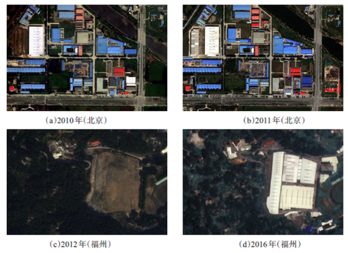
本文以城镇和山区2种不同场景作为研究区域,分别选用北京市局部区域(337×510)和福州市局部区域(689×1045)不同时相的WorldView Ⅱ多光谱影像(包含红、绿、蓝、近红外4个波段,1.8 m空间分辨率)为数据源进行实验。对影像进行辐射校正、几何校正以及匹配等预处理,结果如图3所示。其中,福州试验区2期影像植被种类存在一定变化,但本文重点检测人为地物变化,故不予考虑。
图3 不同时相的研究区真彩色(RGB)影像
Fig. 3 True color composite(RGB) images of case study area at different times
由于影像中变化区域所占比例较小,变化与未变化区域数量悬殊较大,导致Kappa系数评价结果不能正确反映样本数较少的变化区域[25],因此除Kappa系数外,本文还同时利用了漏检率(式(7))和误检率(式(8))2个指标,以便更加客观地反映检测结果的精度。式(7)、(8)中,TPR与FPR分别表示漏检率与误检率,其余各变量含义见表1所示的变化检测误差矩阵。
表1 变化误差矩阵
Tab. 1 Error matrix of change detection
| 实际变化像元数 | 实际未变化像元数 | 行像元数之和 | |
|---|---|---|---|
| 检测变化像元数 | TP | FP | P |
| 检测未变化像元数 | FN | TN | N |
| 列像元数之和 | P′ | N′ | T |
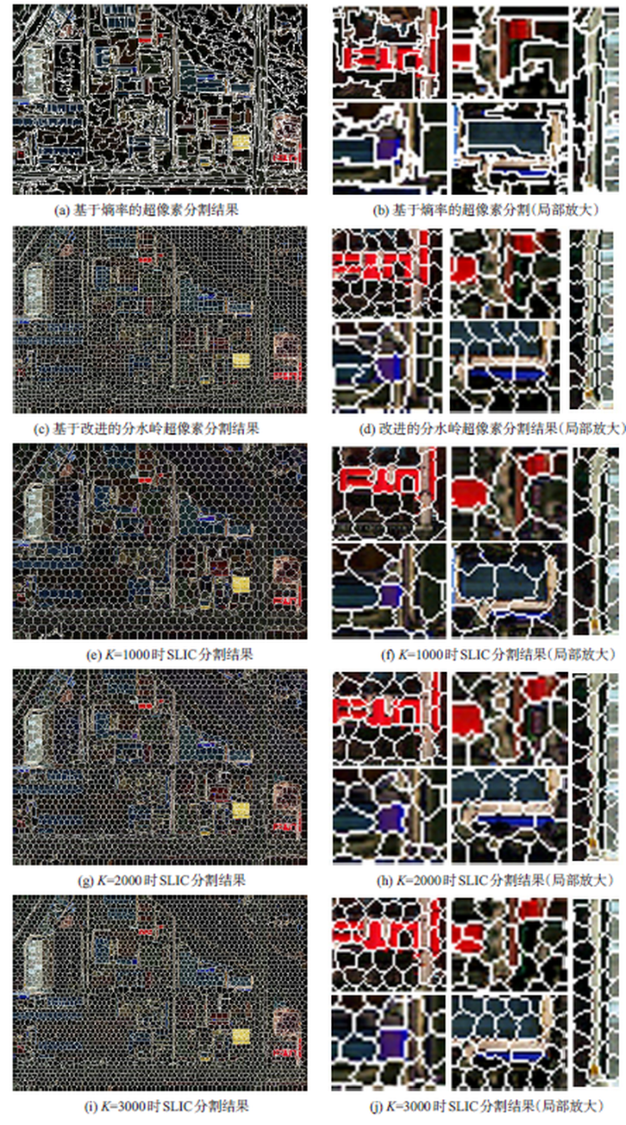
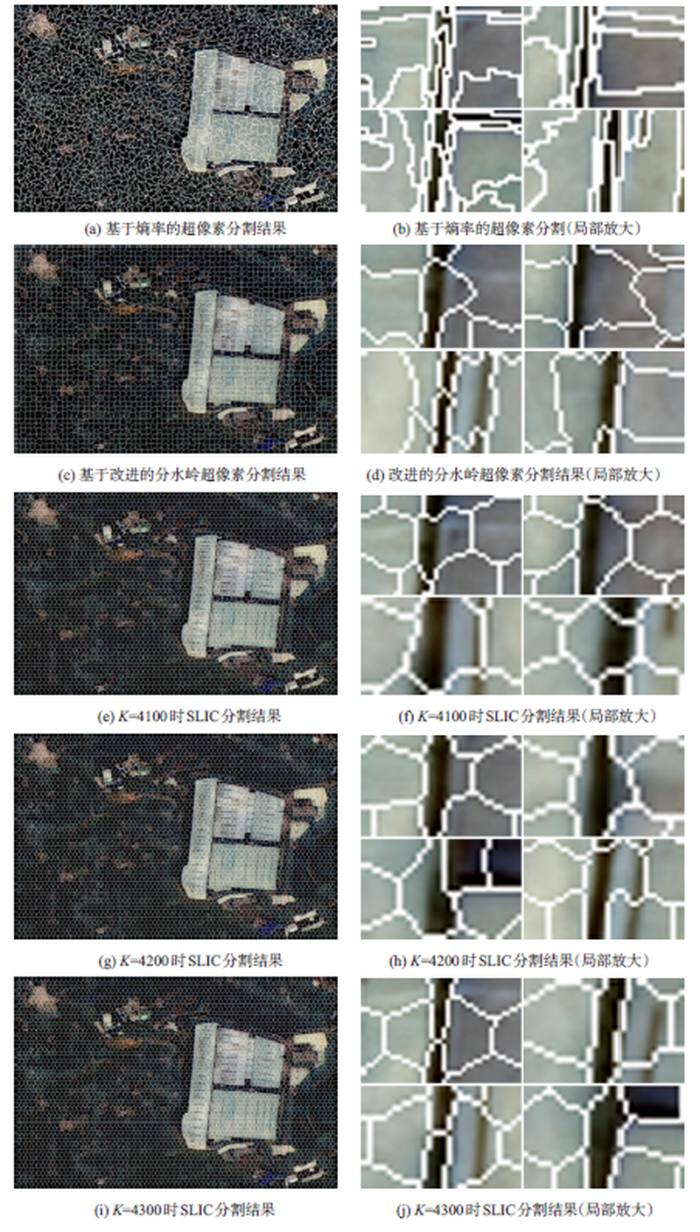
按照本文方法的技术路线,首先对2期影像求差得到差值图像(图4),采用SLIC算法选取不同分割参数对差值影像进行多次分割,保留其中效果最佳的超像素分割结果。图5为SLIC分割与基于熵率的超像素分割以及改进的分水岭超像素分割[26] 3种不同方法针对同一地区的分割结果。
本文用于对比的超像素分割算法均经过多次实验取最优结果,由分割结果可知,基于熵率的分割得到的超像素边缘贴合度好但是超像素形状不规则,超像素紧致度较差;基于改进的分水岭分割得到的超像素形状规则紧密,与SLIC较为相似,但是边缘贴合度较SLIC差,且不能控制生成的超像素数量。在SLIC分割中3种不同K值分割得到的结果与大部分地物边缘吻合较好,当K分别取3000和4300时,2幅影像分割边缘与真实地物边缘吻合达到最佳,细节边缘保持效果更加明显(见图5、6局部放大图)。
图5 北京地区超像素分割结果
Fig. 5 The segmentation results of different superpixel segmentation algorithms in Beijing
图6 福州地区超像素分割结果
Fig. 6 The segmentation results of different superpixel segmentation algorithms in Fuzhou
通过SLIC分割得到超像素对象,以超像素对象为基本处理单元,分别提取差值影像3个波段的均值以及标准差作为超像素的光谱特征,通过灰度共生矩阵求得超像素的熵、能量以及角二阶矩等纹理特征,构成特征向量。设置100个超像素为初始训练样本进行标记,由于初始标记样本数量较少,主动学习选择的样本信息量较少,进而导致训练得到的模型不准确,并且每次迭代选取的样本数过多会增加计算负荷。基于这2点考虑,本文每次迭代向训练集中加入10个样本,将训练的分类器模型用于变化检测,并将本文方法(SLIC-MS、SLIC-MS+ABD)与随机选择学习样本的主动学习方法(SLIC-RS)进行比较,结果如图7所示。
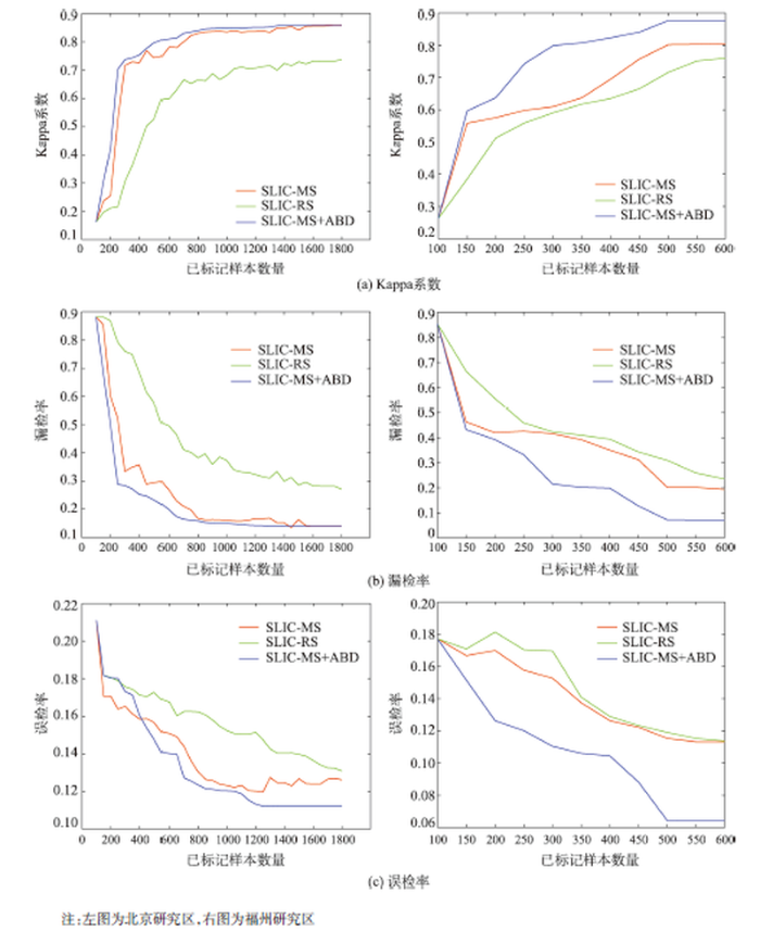
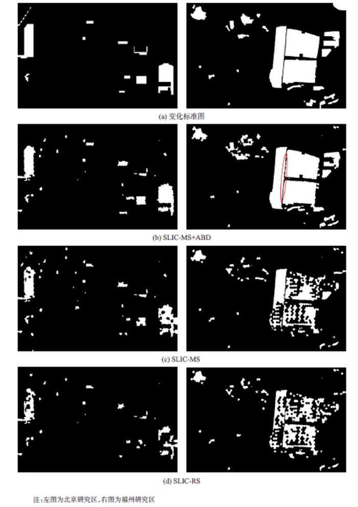
由图7可知,北京研究区建筑物较密集,地物类型较复杂,在迭代初期体现各种方法分类性能的Kappa系数和漏检率2项指标相差不大,这是由于样本数量较少,训练得到的分类器不是很准确,在这种情况下样本选择近似于随机选择,在样本为250(迭代15次)时,体现出SLIC-MS+ABD方法的优越性: Kappa系数由0.4246升至0.7030、漏检率由0.5018下降到0.3286,说明在第15次迭代时,MS+ABD策略选择了信息量更丰富的样本,分类器精度因此得到较大提升。上升过程中存在的小范围波动则是选择样本的信息含量较低所致。随着样本数量的增加,变化检测的精度逐渐稳定提高,而SLIC-MS方法在迭代20次后精度才出现较大提升。值得注意的是,3种方法的误检率都较低,且误检率下降趋势较为接近。虽然SLIC-MS+ABD方法的误检率在前迭代30次时比其他2种方法要高,但是在迭代30次后,误检率有了大幅下降,在迭代50次时(标注样本为700)接近收敛。福州地区地物较简单,覆被多为植被,变化区域明显,故本文提出的2种方法精度提升较快,但SLIC-MS+ABD方法提升趋势明显,迭代收敛速度较快,在第40次迭代时(标注样本为500)达到收敛,且收敛时精度明显高于其他2种方法,同时在迭代过程中波动较小,学习曲线稳定。图8展示了当SLIC-MS+ABD方法达到收敛时3种方法的变化检测结果图。表2展示了当SLIC-MS+ABD方法达到收敛时不同方法的检测 精度。
表2 不同方法的检测精度
Tab. 2 The change detection accuracy of different methods
| 北京 | 福州 | ||||||
|---|---|---|---|---|---|---|---|
| Kappa系数 | 漏检率 | 误检率 | Kappa系数 | 漏检率 | 误检率 | ||
| SLIC-MS+ABD | 0.8306 | 0.1630 | 0.1263 | 0.8763 | 0.0719 | 0.0642 | |
| SLIC-MS | 0.8008 | 0.2106 | 0.1439 | 0.8017 | 0.2018 | 0.1153 | |
| SLIC-RS | 0.6660 | 0.4106 | 0.1625 | 0.7157 | 0.3098 | 0.1190 | |
由图8可知,在迭代次数相同的条件下SLIC-MS+ABD方法能够获得质量较好的检测结果,而SLIC-MS和SLIC-RS这2种方法不能高质量地保持变化区域的完整性以及边界特征,检测结果较为破碎,收敛速度较慢,精度较低。在训练样本较少的情况下,由于SLIC-RS算法在选择样本时是随机的,而SLIC-MS算法在增加训练样本时只是单纯地考虑样本的不确定性,没有考虑训练样本的多样性,加入到训练集中的样本信息量不足,甚至存在冗余样本,没有充分利用分类器模型的学习效能,从而制约了变化检测的精度与效率;SLIC-MS+ABD方法能够检测出绝大部分变化区域,且噪声较少、边缘保持度好(图8(b)中红圈区域)、变化区域结构完整,漏检率和误检率较低。这是由于在少量训练样本的前提下,SLIC-MS+ABD方法能够从未标记的样本中选择对分类器最具学习价值的样本,从而使分类器获取较好的分类性能,减少了人工标注负担,提高了变化检测效率。为说明SLIC-MS+ABD方法在减少人工标注负担上所起的作用,采用迭代次数来反映人工样本标注成本,迭代次数越多标注成本越高。表3展示了在达到相同检测精度(以Kappa 系数为0.7为例)时,3种方法所需的迭代次数。
表3 3种方法达到相同精度所需迭代次数
Tab. 3 The numbers of iteration rounds required by different methods for achieving the same classification accuracy on the two research areas
| 研究区迭代次数 | ||
|---|---|---|
| 北京 | 福州 | |
| SLIC-MS+ABD | 15 | 13 |
| SLIC-MS | 20 | 30 |
| SLIC-RS | 90 | 50 |
SLIC算法分割得到的超像素对象具有边缘特征保持度好、内部同质性强等优势。 MS主动学习方法从未标记样本集中选择不确定性大的样本交由用户标注,但未考虑样本的多样性,对分类器性能的改善作用有限;MS+ABD主动学习方法在确定样本的过程中同时考虑了样本的不确定性与多样性,通过选择最具信息量、最有价值的样本提交用户人工标注,再将其加入到训练集中,明显加快了学习速度。本文提出的SLIC-MS+ABD变化检测方法集成了二者的相对优势,实现了变化检测精度和效率的同时提升。实验结果表明:① SLIC分割产生的超像素对象边缘贴合度以及紧密度较好、超像素内部的同质性较高,避免了地物细节信息的丢失;② 利用主动学习方法只需标记少量训练样本便可以达到较好的检测结果,减少了训练过程中的人工标注成本,有效地提高了变化检测效率。如何合理选择初始样本以及初始样本中各类别样本数目并通过与其它半监督分类方法结合进一步减少样本标注负担、提高算法的泛化能力和鲁棒性是后续研究的目标。
The authors have declared that no competing interests exist.
| [1] |
Change detection from multi-temporal remote sensing images by integrating multiple features [J].
Traditional change detection approaches from multi-temporal remote sensing images are mainly based on spectral information in original images,without utilizing other derived features,such as texture,geometrical structure and shape.With the increasing spatial resolution in remote sensing imagery,change detection only relying on spectral information cannot guarantee the completeness and accuracy of change targets,suggesting the importance to integrate the merits of different features.After extracting multiple features from original images,two change detection procedures based on information fusion strategies are proposed in this paper:weighted similarity distance in one-dimensional feature space,and fuzzy set theory and support vector machines in n-dimensional feature space,respectively.Multi-temporal QuickBird high-resolution images are used as experimental data for land cover change detection over urban areas,and the results demonstrate the effectiveness of the proposed method.By integrating the merits of different features,the stability and applicability can be improved,and the structure and shape can be well preserved to highlight the important change targets at the same time.
|
| [2] |
Digital change detection techniques using remotely sensed data [J]. |
| [3] |
遥感影像变化检测方法探讨 [J].
利用同一区域不同时相的遥感影像进行变化检测的应用一直是遥感应用研究的热点之一.本文对遥感变化检测技术的研究现状和新进展进行了一定的归纳和总结,对以往分类方法进行了介绍,分别对基于像素、基于对象以及结合特定理论的变化检测方法进行了重点讨论,并对每种方法涉及的理论和最新研究进展进行了评述.
Review on change detection methods of remote sensing images [J].
利用同一区域不同时相的遥感影像进行变化检测的应用一直是遥感应用研究的热点之一.本文对遥感变化检测技术的研究现状和新进展进行了一定的归纳和总结,对以往分类方法进行了介绍,分别对基于像素、基于对象以及结合特定理论的变化检测方法进行了重点讨论,并对每种方法涉及的理论和最新研究进展进行了评述.
|
| [4] |
A novel change detection method of multi-resolution remotely sensed images based on the decision level fusion [J].https://doi.org/10.1155/2011/531540 URL [本文引用: 2] 摘要
According to the characteristics and merits of multi-resolution remotely sensed images and objectives of different change detection applications, the idea using coarse to fine (CTF) hierarchical detection and decision level fusion are introduced into change detection process. The technical flow of change detection based on CTF is designed and implemented with multi-temporal ALOS images as the experimental data. The four band ALOS multi-spectral images are viewed as coarse resolution data, and the panchromatic image and fusion image of multispectral and panchromatic data are viewed as fine data. After processing the fine and coarse datasets individually, results are integrated to form a new dataset which reflects the location and intensity of final changes based on specific fusion rules. Land cover change detection of two study case areas over the urban area and mining area of Xuzhou City are conducted. Comparing the proposed approach with other common methods, it is concluded that the proposed CTF decision level fusion change detection approach outperforms other traditional algorithms, and it is effective to conduct change detection using multi-resolution remotely sensed images, further providing the important target change areas of field work.
|
| [5] |
多尺度分割的高分辨率遥感影像变化检测 [J].https://doi.org/10.11834/jrs.20165074 URL [本文引用: 1] 摘要
针对高空间分辨率的遥感影像,提出了一种基于多尺度分割的变化检测算法。采用Mean-Shift分割算法对影像进行多尺度分割,构建了不同尺度上的地理对象,以不同尺度上的地理对象灰度均值构建了变化检测的多尺度特征向量,采用变化矢量分析法获得最后的变化检测结果。以城镇区和农田区的Quick Bird影像对本文算法进行了检验,从精度评价的效果来看,无论城镇区还是农田区,采用面向对象的变化检测方法精度都高于基于单像素的检测方法,且当尺度层数固定时,多尺度组合的变化检测结果优于单一尺度的变化检测结果,对城镇、农田区域的变化检测的精度分别达到87.57%和81.55%。本文算法既可以顾及大面积同质区域变化,又可以反映小的地物目标及边缘部分的变化,能够很好地满足城镇、农田等不同环境背景下的变化检测需求,在国土资源监测中具有一定的应用价值。
Change detection for high-resolution images using multilevel segment method [J].https://doi.org/10.11834/jrs.20165074 URL [本文引用: 1] 摘要
针对高空间分辨率的遥感影像,提出了一种基于多尺度分割的变化检测算法。采用Mean-Shift分割算法对影像进行多尺度分割,构建了不同尺度上的地理对象,以不同尺度上的地理对象灰度均值构建了变化检测的多尺度特征向量,采用变化矢量分析法获得最后的变化检测结果。以城镇区和农田区的Quick Bird影像对本文算法进行了检验,从精度评价的效果来看,无论城镇区还是农田区,采用面向对象的变化检测方法精度都高于基于单像素的检测方法,且当尺度层数固定时,多尺度组合的变化检测结果优于单一尺度的变化检测结果,对城镇、农田区域的变化检测的精度分别达到87.57%和81.55%。本文算法既可以顾及大面积同质区域变化,又可以反映小的地物目标及边缘部分的变化,能够很好地满足城镇、农田等不同环境背景下的变化检测需求,在国土资源监测中具有一定的应用价值。
|
| [6] |
Learning a classification model for segmentation [C]// |
| [7] |
图像分割中的超像素方法研究综述 [J].https://doi.org/10.11834/jig.20150502 URL [本文引用: 1] 摘要
目的超像素(superpixel)是近年来快速发展的一种图像预处理技术,它将图像快速分割为一定数量的具有语义意义的子区域,相比于传统处理方法中的基本单元——像素,超像素更有利于局部特征的提取与结构信息的表达,并且能够大幅度降低后续处理的计算复杂度,在计算机视觉领域尤其是图像分割中得到了广泛的应用,为使国内外研究者对超像素理论及其在图像分割中的应用有一个比较全面的认识,对其进行系统综述。方法以图像分割为应用背景,在广泛调研文献特别是超像素最新发展成果的基础上,结合对比实验,对每种方法的基本思想、方法特点进行总结,并对超像素分割目前存在的局限性进行说明,对未来可能发展方向进行展望。结果不同的超像素分割算法在分割思想、性能特点上各不相同。当前的超像素方法普遍在超像素数量、紧密度与分割质量、算法实用性之间存在相互制约,同时对于某些特殊目标的分割也难以取得较好的结果。结论超像素作为一种有效的图像预处理手段具有较高的研究价值,但针对目前超像素存在的一些局限性还需要进行深入的研究。
Review on super-pixel methods in image segmentation [J].https://doi.org/10.11834/jig.20150502 URL [本文引用: 1] 摘要
目的超像素(superpixel)是近年来快速发展的一种图像预处理技术,它将图像快速分割为一定数量的具有语义意义的子区域,相比于传统处理方法中的基本单元——像素,超像素更有利于局部特征的提取与结构信息的表达,并且能够大幅度降低后续处理的计算复杂度,在计算机视觉领域尤其是图像分割中得到了广泛的应用,为使国内外研究者对超像素理论及其在图像分割中的应用有一个比较全面的认识,对其进行系统综述。方法以图像分割为应用背景,在广泛调研文献特别是超像素最新发展成果的基础上,结合对比实验,对每种方法的基本思想、方法特点进行总结,并对超像素分割目前存在的局限性进行说明,对未来可能发展方向进行展望。结果不同的超像素分割算法在分割思想、性能特点上各不相同。当前的超像素方法普遍在超像素数量、紧密度与分割质量、算法实用性之间存在相互制约,同时对于某些特殊目标的分割也难以取得较好的结果。结论超像素作为一种有效的图像预处理手段具有较高的研究价值,但针对目前超像素存在的一些局限性还需要进行深入的研究。
|
| [8] |
Normalized Cuts and Image Segmentation [J].https://doi.org/10.1109/34.868688 URL [本文引用: 1] 摘要
ABSTRACT We propose a novel approach for solving the perceptual grouping problem in vision. Rather than focusing on local features and their consistencies in the image data, our approach aims at extracting the global impression of an image. We treat image segmentation as a graph partitioning problem and propose a novel global criterion, the normalized cut, for segmenting the graph. The normalized cut criterion measures both the total dissimilarity between the different groups as well as the total similarity within the groups. We show that an efficient computational technique based on a generalized eigenvalue problem can be used to optimize this criterion. We have applied this approach to segmenting static images and found results very en- couraging.
|
| [10] |
Superpixel lattices [C]// |
| [11] |
Entropy rate superpixel segmentation [C]// |
| [12] |
Watersheds in digital spaces: an efficient algorithm based on immersion simulations [J].https://doi.org/10.1109/34.87344 URL [本文引用: 1] 摘要
A fast and flexible algorithm for computing watersheds in digital gray-scale images is introduced. A review of watersheds and related motion is first presented, and the major methods to determine watersheds are discussed. The algorithm is based on an immersion process analogy, in which the flooding of the water in the picture is efficiently simulated using of queue of pixel. It is described in detail provided in a pseudo C language. The accuracy of this algorithm is proven to be superior to that of the existing implementations, and it is shown that its adaptation to any kind of digital grid and its generalization to n-dimensional images (and even to graphs) are straightforward. The algorithm is reported to be faster than any other watershed algorithm. Applications of this algorithm with regard to picture segmentation are presented for magnetic resonance (MR) imagery and for digital elevation models. An example of 3-D watershed is also provided.
|
| [13] |
TurboPixels: Fast superpixels using geometric flows [J].https://doi.org/10.1109/TPAMI.2009.96 URL PMID: 19834148 [本文引用: 1] 摘要
We describe a geometric-flow-based algorithm for computing a dense oversegmentation of an image, often referred to as superpixels. It produces segments that, on one hand, respect local image boundaries, while, on the other hand, limiting undersegmentation through a compactness constraint. It is very fast, with complexity that is approximately linear in image size, and can be applied to megapixel sized images with high superpixel densities in a matter of minutes. We show qualitative demonstrations of high-quality results on several complex images. The Berkeley database is used to quantitatively compare its performance to a number of oversegmentation algorithms, showing that it yields less undersegmentation than algorithms that lack a compactness constraint while offering a significant speedup over N-cuts, which does enforce compactness.
|
| [14] |
SLIC superpixels compared to State-of-the-Art superpixel methods [J].https://doi.org/10.1109/TPAMI.2012.120 URL PMID: 22641706 [本文引用: 1] 摘要
Computer vision applications have come to rely increasingly on superpixels in recent years, but it is not always clear what constitutes a good superpixel algorithm. In an effort to understand the benefits and drawbacks of existing methods, we empirically compare five state-of-the-art superpixel algorithms for their ability to adhere to image boundaries, speed, memory efficiency, and their impact on segmentation performance. We then introduce a new superpixel algorithm, simple linear iterative clustering (SLIC), which adapts a k-means clustering approach to efficiently generate superpixels. Despite its simplicity, SLIC adheres to boundaries as well as or better than previous methods. At the same time, it is faster and more memory efficient, improves segmentation performance, and is straightforward to extend to supervoxel generation.
|
| [15] |
Efficient image segmentation algorithm using SLIC superpixels and boundary-focused region merging [C]// |
| [16] |
SLIC Superpixels for efficient graph-based dimensionality reduction of hyperspectral imagery [C]// |
| [17] |
Classification of detected changes from multitemporal High-Res Xband SAR Images: Intensity and texture descriptors from super pixels [J].https://doi.org/10.1109/JSTARS.2016.2621818 URL [本文引用: 1] 摘要
Remote sensing has been widely employed for monitoring land cover and usage by change detection techniques. In this paper, we cope with the early detection of the first signs of deforestation, which is the gateway for illegal activities, such as unauthorized urban sprawl and grazing use. In recent years, object-based approaches have emerged as a more suitable alternative than pixel-based methods for change detection in remote sensing images. Even though several classifiers have been tested, there was little effort in selecting appropriated features for the classification of detected changes. After a deep analysis of the existing segmentation, feature extraction, and classification approaches, we propose an object-based methodology that consists of: 1) segmenting multitemporal Xband high-resolution synthetic aperture radar (SAR) images into superpixels employing the simple linear iterative clustering algorithm; 2) extracting features using the object correlation images framework and with the gray-level cooccurrence matrix; and 3) classifying areas into unchanged, deforestation, and other changes by means of a multilayer perceptron supervised learning technique. Experiments were performed using high-resolution SAR images obtained by the airborne sensor OrbiSAR-2 from BRADAR in challenging scenarios of the Brazilian Atlantic Forest, including a wide variety of vegetation, rivers, sea coasts, urban, harvest and open areas, and humidity changes. We perform an extensive experimental analysis of the results, comparing the proposed method with a state-of-the-art approach. The results demonstrate that our method yields an improvement of over 10% in the accuracy while detecting changes and classifying deforested areas.
|
| [18] |
Superpixel-based roughness measure for multispectral satellite image segmentation [J].https://doi.org/10.3390/rs71114620 URL [本文引用: 1] 摘要
The new generation of artificial satellites is providing a huge amount of Earth observation images whose exploitation can report invaluable benefits, both economical and environmental. However, only a small fraction of this data volume has been analyzed, mainly due to the large human resources needed for that task. In this sense, the development of unsupervised methodologies for the analysis of these images is a priority. In this work, a new unsupervised segmentation algorithm for satellite images is proposed. This algorithm is based on the rough-set theory, and it is inspired by a previous segmentation algorithm defined in the RGB color domain. The main contributions of the new algorithm are: (i) extending the original algorithm to four spectral bands; (ii) the concept of the superpixel is used in order to define the neighborhood similarity of a pixel adapted to the local characteristics of each image; (iii) and two new region merged strategies are proposed and evaluated in order to establish the final number of regions in the segmented image. The experimental results show that the proposed approach improves the results provided by the original method when both are applied to satellite images with different spectral and spatial resolutions.
|
| [19] |
Fast Segmentation and classification of very high resolution remote sensing data using SLIC superpixels [J].https://doi.org/10.3390/rs9030243 URL [本文引用: 1] 摘要
Speed and accuracy are important factors when dealing with time-constraint events for disaster, risk, and crisis-management support. Object-based image analysis can be a time consuming task in extracting information from large images because most of the segmentation algorithms use the pixel-grid for the initial object representation. It would be more natural and efficient to work with perceptually meaningful entities that are derived from pixels using a low-level grouping process (superpixels). Firstly, we tested a new workflow for image segmentation of remote sensing data, starting the multiresolution segmentation (MRS, using ESP2 tool) from the superpixel level and aiming at reducing the amount of time needed to automatically partition relatively large datasets of very high resolution remote sensing data. Secondly, we examined whether a Random Forest classification based on an oversegmentation produced by a Simple Linear Iterative Clustering (SLIC) superpixel algorithm performs similarly with reference to a traditional object-based classification regarding accuracy. Tests were applied on QuickBird and WorldView-2 data with different extents, scene content complexities, and number of bands to assess how the computational time and classification accuracy are affected by these factors. The proposed segmentation approach is compared with the traditional one, starting the MRS from the pixel level, regarding geometric accuracy of the objects and the computational time. The computational time was reduced in all cases, the biggest improvement being from 5 h 35 min to 13 min, for a WorldView-2 scene with eight bands and an extent of 12.2 million pixels, while the geometric accuracy is kept similar or slightly better. SLIC superpixel-based classification had similar or better overall accuracy values when compared to MRS-based classification, but the results were obtained in a fast manner and avoiding the parameterization of the MRS. These two approaches have the potential to enhance the automation of big remote sensing data analysis and processing, especially when time is an important constraint.
|
| [17] |
最小差异采样的主动学习图像分类方法 [J].Minimal difference sampling for active learning image classification [J]. |
| [20] |
主动学习与图的半监督相结合的高光谱影像分类 [J].https://doi.org/10.11947/j.AGCS.2015.20140221 URL Magsci [本文引用: 1] 摘要
<p>针对当前高光谱影像分类时,人工标注样本费时费力以及大量未标记样本未有效利用等问题,提出了一种主动学习与图的半监督相结合的高光谱影像分类方法。首先,将像素的光谱信息与其邻域内的空间信息相结合,利用重排序机制得到一种旋转不变的空谱特征表达。在此基础上,利用主动学习算法选择最不确定性样本(即分类模糊度最大的样本),提交操作者标注得到标记样本集。最后将该标记样本与未标记样本组合,用于图的半监督分类。该算法可保证类别边界样本的选择,利于分类器的边界构造,同时,在较少标记样本情况下,通过引入大量的未标记样本,可以达到较好的分类效果。在3幅真实高光谱影像上的试验表明,该方法可以取得精度较高的分类结果。</p>
Semi-supervised graph-based hyperspectral image classification with active learning [J].https://doi.org/10.11947/j.AGCS.2015.20140221 URL Magsci [本文引用: 1] 摘要
<p>针对当前高光谱影像分类时,人工标注样本费时费力以及大量未标记样本未有效利用等问题,提出了一种主动学习与图的半监督相结合的高光谱影像分类方法。首先,将像素的光谱信息与其邻域内的空间信息相结合,利用重排序机制得到一种旋转不变的空谱特征表达。在此基础上,利用主动学习算法选择最不确定性样本(即分类模糊度最大的样本),提交操作者标注得到标记样本集。最后将该标记样本与未标记样本组合,用于图的半监督分类。该算法可保证类别边界样本的选择,利于分类器的边界构造,同时,在较少标记样本情况下,通过引入大量的未标记样本,可以达到较好的分类效果。在3幅真实高光谱影像上的试验表明,该方法可以取得精度较高的分类结果。</p>
|
| [21] |
基于主动学习和半监督学习的多类图像分类 [J].https://doi.org/10.3724/SP.J.1004.2011.00954 URL Magsci [本文引用: 1] 摘要
多数图像分类算法需要大量的训练样本对分类器模型进行训练.在实际应用中, 对大量样本进行标注非常枯燥、耗时.对于一些特殊图像,如合成孔径雷达 (Synthetic aperture radar, SAR)图像, 对其内容判读非常困难,因此能够获得的标注样本数量非常有限. 本文将基于最优标号和次优标号(Best vs second-best, BvSB)的主动学习和带约束条件的自学习(Constrained self-training, CST) 引入到基于支持向量机(Support vector machine, SVM)分类器的图像分类算法中,提出了一种新的图像分类方法.通过BvSB 主动学习去挖掘那些对当前分类器模型最有价值的样本进行人工标注,并借助CST半 监督学习进一步利用样本集中大量的未标注样本,使得在花费较小标注代价情况下, 能够获得良好的分类性能.将新方法与随机样本选择、基于熵的不确定性采样主动学 习算法以及BvSB主动学习方法进行了性能比较.对3个光学图像集及1个SAR图像集分类 问题的实验结果显示,新方法能够有效地减少分类器训练时所需的人工标注样本的数 量,并获得较高的准确率和较好的鲁棒性.
Multi-class image classification with active learning and semi-supervised learning [J].https://doi.org/10.3724/SP.J.1004.2011.00954 URL Magsci [本文引用: 1] 摘要
多数图像分类算法需要大量的训练样本对分类器模型进行训练.在实际应用中, 对大量样本进行标注非常枯燥、耗时.对于一些特殊图像,如合成孔径雷达 (Synthetic aperture radar, SAR)图像, 对其内容判读非常困难,因此能够获得的标注样本数量非常有限. 本文将基于最优标号和次优标号(Best vs second-best, BvSB)的主动学习和带约束条件的自学习(Constrained self-training, CST) 引入到基于支持向量机(Support vector machine, SVM)分类器的图像分类算法中,提出了一种新的图像分类方法.通过BvSB 主动学习去挖掘那些对当前分类器模型最有价值的样本进行人工标注,并借助CST半 监督学习进一步利用样本集中大量的未标注样本,使得在花费较小标注代价情况下, 能够获得良好的分类性能.将新方法与随机样本选择、基于熵的不确定性采样主动学 习算法以及BvSB主动学习方法进行了性能比较.对3个光学图像集及1个SAR图像集分类 问题的实验结果显示,新方法能够有效地减少分类器训练时所需的人工标注样本的数 量,并获得较高的准确率和较好的鲁棒性.
|
| [22] |
Active learning methods for remote sensing image classification [J].https://doi.org/10.1109/TGRS.2008.2010404 URL [本文引用: 1] 摘要
In this paper, we propose two active learning algorithms for semiautomatic definition of training samples in remote sensing image classification. Based on predefined heuristics, the classifier ranks the unlabeled pixels and automatically chooses those that are considered the most valuable for its improvement. Once the pixels have been selected, the analyst labels them manually and the process is iterated. Starting with a small and nonoptimal training set, the model itself builds the optimal set of samples which minimizes the classification error. We have applied the proposed algorithms to a variety of remote sensing data, including very high resolution and hyperspectral images, using support vector machines. Experimental results confirm the consistency of the methods. The required number of training samples can be reduced to 10% using the methods proposed, reaching the same level of accuracy as larger data sets. A comparison with a state-of-the-art active learning method, margin sampling, is provided, highlighting advantages of the methods proposed. The effect of spatial resolution and separability of the classes on the quality of the selection of pixels is also discussed.
|
| [23] |
SVM active learning approach for image classification using spatial information [J].https://doi.org/10.1109/TGRS.2013.2258676 URL [本文引用: 1] 摘要
In the last few years, active learning has been gaining growing interest in the remote sensing community in optimizing the process of training sample collection for supervised image classification. Current strategies formulate the active learning problem in the spectral domain only. However, remote sensing images are intrinsically defined both in the spectral and spatial domains. In this paper, we explore this fact by proposing a new active learning approach for support vector machine classification. In particular, we suggest combining spectral and spatial information directly in the iterative process of sample selection. For this purpose, three criteria are proposed to favor the selection of samples distant from the samples already composing the current training set. In the first strategy, the Euclidean distances in the spatial domain from the training samples are explicitly computed, whereas the second one is based on the Parzen window method in the spatial domain. Finally, the last criterion involves the concept of spatial entropy. Experiments on two very high resolution images show the effectiveness of regularization in spatial domain for active learning purposes.
|
| [24] |
A Survey of active learning algorithms for supervised remote sensing image classification [J].https://doi.org/10.1109/JSTSP.2011.2139193 URL [本文引用: 1] 摘要
Defining an efficient training set is one of the most delicate phases for the success of remote sensing image classification routines. The complexity of the problem, the limited temporal and financial resources, as well as the high intraclass variance can make an algorithm fail if it is trained with a suboptimal dataset. Active learning aims at building efficient training sets by iteratively improving the model performance through sampling. A user-defined heuristic ranks the unlabeled pixels according to a function of the uncertainty of their class membership and then the user is asked to provide labels for the most uncertain pixels. This paper reviews and tests the main families of active learning algorithms: committee, large margin, and posterior probability-based. For each of them, the most recent advances in the remote sensing community are discussed and some heuristics are detailed and tested. Several challenging remote sensing scenarios are considered, including very high spatial resolution and hyperspectral image classification. Finally, guidelines for choosing the good architecture are provided for new and/or unexperienced user.
|
| [25] |
Active and semisupervised learning for the classification of remote sensing images [J].https://doi.org/10.1109/TGRS.2014.2305805 URL [本文引用: 2] 摘要
This paper aims at analyzing and comparing active learning (AL) and semisupervised learning (SSL) methods for the classification of remote sensing (RS) images. We present a literature review of the two learning paradigms and compare them theoretically and experimentally when addressing classification problems characterized by few training samples (w.r.t. the number of features) and affected by sample selection bias. Commonalities and differences are highlighted in the context of a conceptual framework used to describe the workflow of the two approaches. We point out advantages and disadvantages of the two approaches, delineating the boundary conditions on the applicability of the two paradigms with respect to both the amount and the quality of available training samples. Moreover, we investigate the integration of concepts that are in common between the two learning paradigms for improving state-of-the-art techniques and combining AL and SSL in order to jointly leverage the advantages of both approaches. In this framework, we propose a novel SSL algorithm that improves the progressive semisupervised support vector machine by integrating concepts that are usually considered in AL methods. We performed several experiments considering both synthetic and real multispectral and hyperspectral RS data, defining different classification problems starting from different initial training sets. The experiments are carried out considering classification methods based on support vector machines.
|
| [26] |
Incorporating diversity in active learning with support vector machines [C]// |
| [27] |
面向对象的高分辨率影像城市多特征变化检测研究 [D].
Object-oriented change detection with multi-feature in urban high-resolution remote sensing imagery [D].
|
| [28] |
Watershed superpixel [C]//
|

/
| 〈 |
|
〉 |

