宋晓阳 , 黄耀欢, 董东林
SONG Xiaoyang, HUANG Yaohuan, DONG Donglin
通讯作者:
收稿日期: 2017-12-25
修回日期: 2018-01-27
网络出版日期: 2018-05-20
版权声明: 2018 《地球信息科学学报》编辑部 《地球信息科学学报》编辑部 所有
基金资助:
作者简介:
作者简介:宋晓阳(1988-),女,博士生,主要从事GIS应用研究。E-mail: songxy@student.cumtb.edu.cn
展开
摘要
城市土地利用是城市生态学中的关键问题,深入了解城市的土地利用对合理规划城市功能分区、提升用地效益、促进区域经济与环境发展具有重要意义。因此,城市土地利用类型分类研究一直是城市规划学和城市地理学研究的核心内容之一。快速发展的无人机技术为城市土地利用分类提供了丰富的数据支撑,基于无人机遥感影像建立的数字表面模型(DSM)和数字正射影像(DOM)可以有效提高城市土地利用分类的精度。为了充分利用无人机遥感影像的丰富信息,本文提出了一种融合高分辨率DOM和DSM的城市土地利用分类方法。本文融合了DOM和DSM作为数据源。在面向对象分类方法的基础上,DSM分别被用于多尺度分割过程中像元融合的最终阈值和地物分类过程中的地物高度特征。该方法在天津市宝坻区的京津新城进行了验证,结果表明,相对于最初的多尺度分割方法,融合DSM后的多尺度分割方法的分割质量指数(QR)、过分割指数(OR)、欠分割指数(UR)和综合指数(CR)都有所降低,分割效果明显提高。优化后的面向对象分类方法,在分类精度上有所提高,尤其是道路、建筑物和其他建设用地。总体精度由85%提高到了87.25%,Kappa系数由0.79提高到0.82。由此可看出,优化后的面向对象分类方法可以更有效地进行城市土地利用分类。
关键词:
Abstract
Urban land use is a key issue of urban ecology. It is of great significance to understand the urban land use for planning urban functional zones, improving land use efficiency, estimating human population, analyzing urban landscape and promoting regional economic and environmental development. Therefore, urban land use classification research has been one of the core contents of urban planning and urban geography. With the rapid development of Unmanned Aerial Vechicle (UAV) technology, rich UAV data have widely been used in different kinds of fields, especially in the urban land use classification. Digital surface model (DSM) and digital orthophoto map (DOM) obtained from UAV remote sensing images can effectively improve the accuracy of urban land use classification. In order to make full use of the rich information of UAV remote sensing images, an urban land use classification method is proposed using high-resolution DOM and DSM. In this study, the composite bands of DOM and DSM were used as data source. Considering the characteristics of urban land use, the object-oriented classification method was optimized by combining DOM spectral information with DSM, which is used as the final threshold of the pixel merge in multi-resolution segmentation and as height feature in objects classification, respectively. The method was validated in Jingjinxincheng located in Baodi District, Tianjin City. The results showed that, comparing with the initial multi-resolution segmentation method, all of the segmentation quality rate (QR), over-segmentation rate (OR), under-segmentation rate (UR) and comprehensive rate (CR) of optimized multi-resolution segmentation method were reduced, and the effects of image segmentation has been improved significantly. The optimized object-oriented classification method improved the classification accuracy, especially for the extraction of roads, buildings and other constructions. The overall accuracy of the classification results increased from 85% to 87.25% and the Kappa coefficient also increased from 0.79 to 0.82. Therefore, the optimized object-oriented classification method can be used for urban land use study more effectively.
Keywords:
由人类活动引起的土地利用变化被认为是全球和区域气候变化的重要驱动因素[1,2],土地利用不但影响了气候、土壤和水文等自然环境要素[3],还造成了生物多样性、生态系统的物质循环与能力流动的巨大变化[4]。随着社会经济的快速发展,城市化进程不断加快,城市土地利用变化十分剧烈[5]。因此城市土地利用/土地覆被变化受到了科学界的广泛关注,一直是国内外学者的研究热点。
随着空间技术发展,运用遥感影像对城市土地利用进行分类已经得到广泛应用。DStow等[6]基于QuickBird卫星遥感影像数据,采用面向对象方法,提取加纳阿克拉市的城区建筑物,总体精度达到75%。郑盛等[7]利用中巴地球资源卫星(CBERS)和环境与灾害监测预报小卫星B星(HJ-1B 星)光学数据,基于最大似然法对深圳土地利用进行了分类研究。Myint 等[8]利用亚利桑那凤凰城中部的QuickBird卫星遥感影像数据验证了面向对象分类方法的效果,结果表明面向对象方法可以有效进行城市土地利用。周亦等以高分一号卫星数据为数据源,内蒙古自治区包头市和江苏省徐州市为研究区,采用面向对象分类方法进行了土地利用分类[9]。然而,随着城市的快速发展,城市环境越来越复发,而且由于遥感卫星数据很容易受到天气的影响,多光谱遥感影像会受到云的影响,以至于影像信息不完整[10],仅依靠单一的遥感数据源很难满足城市土地利用研究的需求。数字表面模型(DSM)信息等许多辅助信息被用于土地利用分类研究,提高分类精度[11,12]。Zhou 等[13]利用DSM来区分透水面和不透水面,Miliaresis等[14]融合了从LIDAR数据反演的DSM,用面向对象方法提取了建筑物。然而,由于激光雷达数据的不连续性和不规则性,很难直接进行土地利用分类。
近年来,无人机遥感技术发展迅速,因其可以弥补卫星在多云雾地区难以获取遥感数据的缺陷,获得具有更高分辨率、更丰富信息的遥感影像,已成为遥感监测的一种重要手段[15]。胡勇等[16]利用无人机遥感影像提取了重庆市长寿区双荣珍的农村房屋,取得了较好的效果。付萧等[17]充分利用无人机灵活性较高的优点,进行了山区地体利用信息动态监测,快速、高效的获得了土地利用变更信息。但是在大多数应用中,无人机遥感影像仅仅作为高分辨率影像,影像信息利用率较低。本研究为了充分利用无人机高分辨率遥感影像的丰富信息,提出了针对城市土地利用融合DSM信息的面向对象分类方法,即在面向对象分类方法的2个关键步骤(多尺度分割和地物分类)中加入高度信息DSM,以期提高城市土地利用分类的精度。
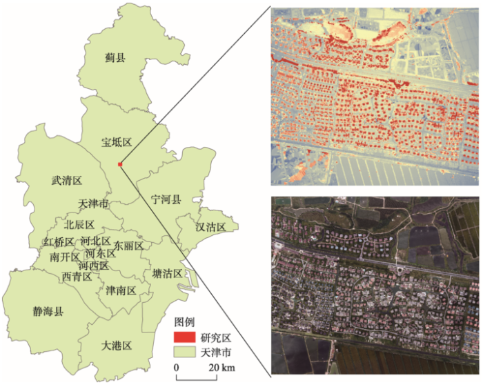
京津新城位于天津市宝坻区,处于环渤海湾经济区的心脏地带,地处北温带大陆性气候,地热和其他自然资源丰富。京津新城规划总面积53 km2,是2006年经国务院批准设立的、天津市在滨海新区开发开放战略中重点打造的十一座新城之一。京津新城以地热综合开发为特色,着力培育旅游度假、温泉疗养、生态居住、文化教育、会议会展、现代金融服务等新兴产业,是以现代服务业为特色的新型城市。本研究区位于京津新城的西南部,地理坐标为39°31′ N,117°22′ E,是一片别墅区。
利用多旋翼无人机平台获取遥感影像,影像拍摄时间为2017年9月11日,设定的无人机飞行高度是254 m,飞翔方向重叠度是70%,旁向的重叠度则是40%。飞行共获得700张影像,整体覆盖了约 2 km2。搭载的相机是FC6310,镜头焦距为8.8 mm。无人机原始影像是真彩色影像,包括红、绿、蓝3个波段,分辨率为7.7 cm。通过旋转影像、畸形变差改正、增强处理、空三加密等处理,获取DSM数据和DOM数据,分辨率都为7.7 cm。考虑到数据边缘数据有缺失,本文裁取了中间一部分矩形区域作为研究区,如图1所示。从影像中可以看出,研究区土地利用类型比较简单,主要包括有居民地、道路、水体、绿地等。
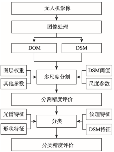
无人机遥感影像不仅具有高空间分辨率,而且具有丰富的内部纹理和形状信息。本文在面向对象分类方法的基础上,融合高度信息DSM,提出了针对城市土地利用的面向对象分类方法(图2)。在优化的面向对象分类方法中,在关键步骤多尺度分割过程中,DSM被用作其中像元合并的最终阈值;在地物分类过程中,DSM被用作描述地物图斑的特征值。
图2 基于无人机遥感的城市土地利用分类流程
Fig. 2 Flow chart of land use classification using UAV remote sensing imagery
多尺度分割是一个自下而上基于区域生长合并的分割方法,通过分析像元的相似性,将相邻的相同或相似像元合并成一个不规则的多边形对象[18]。在分割程序执行过程中,成对的对象迭代合并,相邻对象的同质性是判断对象是否合并的唯一准则。多尺度分割指的是多次分割的迭代过程,需要设定每个图层的权重、光谱因子、光滑度因子以及分割尺度4个参数,其中每个图层的权重、光谱因子和光滑度因子3个参数用来计算异质性,分割尺度用来终止分割[19,20]。分割的流程具体如下:① 第一次分割以单个像元作为种子对象,分析该种子对象与其相邻像元的异质性,找到异质性最小的邻居像元;② 计算该邻居像元与其邻居像元的异质性,找到该邻居像元的异质性最小的邻居像元,并判断其是否为种子对象;③ 如果是种子对象,则种子对象和种子像元的邻居像元互为异质性最小邻居像元,且异质性小于分割尺度,则合并2个像元;④ 如果不是种子对象,则以种子像元的邻居像元,作为新的种子对象,继续寻找新的种子对象的最小异质性像元;⑤ 所有像元遍历完成后,以第一次分割出来的多边形为新的起点开始第二次分割;⑥ 多次迭代分割过程,直至所有的对象与邻居对象的最小异质性都大于设定的分割尺度[21]。
异质性(f)由光谱异质性和形状异质性的加权值计算,公式如下:
式中:hcolor为光谱异质性;hshape为形状异质性;w1为光谱异质性权重。
光谱异质性是由对象像元的光谱值计算的:
式中:b为影像的总波段数;wc为影像中c波段的权重;nm为合并后对象的像元个数;σm为合并后对象的标准方差;n1、n2为合并前2个相邻对象的像元个数;σ1、σ2为合并前2个相邻对象的标准方差。
形状异质性是由对象的形状计算的:
式中:w2为紧致度的权重;hcom为紧致度异质性;hsmooth为光滑度异质性。
与以往研究[22]将DSM当做一个图层用来计算光谱异质性不同,本文不仅仅将DSM作为一个图层,而且将其作为决定相邻对象是否合并的条件阈值。城区中主要的土地类型包括建筑物、绿地、水体及道路等,DSM可以有效地区分各类地物。例如,建筑物是城市中占地最大的地物类型,DSM值在建筑物边界内部均匀一致,只有在边界处存在着高度的剧烈变化[23],因此DSM可以有效区分建筑物和道路等其他人工地物。DSM作为决定2个成对对象是否合并的最后一个准则,公式如下:
式中:Merge等于1,则2个对象合并;Merge等于0,则2个对象不合并。如果2个对象Object1和 Object2通过分析其与相邻对象的异质性,发现2个对象可以合并,则U[Object1,Object2]为1。PN是2个对象相邻像元对的个数,PN(Δdsm≥3 m)是其中DSM差值大于3 m的相邻像元对的个数。
分割过程中,对象合并过程具体如图3所示。
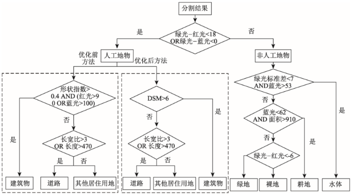
通过多尺度分割,影像变为多个由同质像元组成的不规则多边形对象。本研究区地物比较简单,且分类比较明显,因此本文采用基于规则的分类方法。通过分析分割后的对象的信息,组合各种不同的特征,建立规则集,实现对研究区的分类。对象特征一般包含光谱特征、形状特征和纹理特征。光谱特征包含光谱均值、亮度值和光谱标准差等;形状特征包含面积、长宽比等;纹理特征是基于灰度共生矩阵计算的熵、对比度和相关度等。DSM可以有效的表达地表建筑物、桥梁及树木等各类地物的高度信息,因此DSM作为高度信息被加入到规则集中。
根据已有的参考文献及研究区的背景知识和目视解译情况[24,25,26],本文定义了耕地、建筑物、道路、水体、绿地及其他居住用地。通过分析影像和地物类别,首先利用光谱信息将所有地物分成人工地物和非人工地物2类。人工地物包括建筑物、道路及其他居住用地。非人工地物包括水体和绿地。然后根据高度信息提取人工地物中的建筑物,根据形状及纹理信息区分道路和其他居住用地,根据光谱和纹理信息区分水体和绿地,完成城市土地利用分类。图4为构建的规则集。
本文采用遥感影像分割精度评价指标来对分割结果进行评价,指标包括分割质量合格率(QR)、过分割指数(OR)、欠分割指数(UR)和综合指数(CR)[27,28,29]。具体指标计算方法如表1所示。
表1 分割结果评价指标
Tab. 1 Metrics of segmentation accuracy assessment
| 评价指数 | 公式 | 说明 |
|---|---|---|
| QR | x是指实际的地物对象,y是指的分割结果。 | |
| OR | ||
| UR | ||
| CR |
本文基于分类结果和人工目视解译结果,构建混淆矩阵进行分类精度评价。根据混淆矩阵。计算分类精度评价指标:用户精度(UA)、制图精度(PA)、总体精度(OA)和kappa系数(Ka)[30]。具体指标计算方法如表2所示。
表2 分类结果评价指标
Tab. 2 Metrics of classification accuracy assessment
| 评价指标 | 公式 | 说明 |
|---|---|---|
| UA | r是混淆矩阵中总列数(即总的类别数);xii是混淆矩阵中第i行第i列上像元数量(即正确分类的数目);xi+和x+i分别是第i行和第i列的总像元数量;N是总的用于精度评估的像元数量 | |
| PA | ||
| OA | ||
| Ka |
为了与加入DSM的多尺度分割方法相比,本文采用原始的多尺度分割方法对本研究区进行了分割。两次分割采用同样的分割参数,考虑到影像分辨率比较高,而且地物比较分明,因此分割尺度为200。无人机遥感影像只有红绿蓝3个波段,每个波段都一样重要,因此每个图层的权重都设为1。DSM作为其中的一个图层,图层的权重也设为1。光谱因子权重设为0.8,形状权重为0.2,紧致度和光滑度的权重都为0.5。
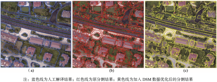
分割结果直接影响分类结果,分析比较2种方法的分割结果是很有必要的。利用QR、OR、UR和CR 4个指标来定量评价2种方法的分割效果。在2个分割结果中选取多组图斑进行评价指标的计算,参考数据为手工数字化的该区的地物,参考数据含有30个样本,为得到准确的评价结果,样本尽量包括不同类型、不同面积的地物图斑。图5展示了一组典型地物的分割结果与参考数据的对比,蓝色实线为手工数字化分割参考数据,红色实线为原影像分割方法分割的结果,黄色实线为加入DSM数据的影像分割的结果。其中手工数字化将图像分割成了119个对象,原始分割方法将图像分割成了289个对象,加入DSM数据后分割将影像分割成了317个对象。从分割结果的图斑个数来看,加入DSM后,由于加入了新的条件,分割的图斑有所增加。从2种分割方法的评价结果来看(表3),二者QR有细微的差别,相差0.05,加入DSM后分割质量有略微提升。2种方法的OR都接近0.5,存在过分割情况,而未加入DSM的分割方法更为严重。而2种方法的UR没有较大差别,基本一致欠分割情况较轻。从4种指数综合来看,加入DSM数据,优化后的分割方法的具有更好的分割效果。
表3 2种分割方法的评价结果
Tab. 3 Assessment results of two segmentation methods
| QR | OR | UR | CR | |
|---|---|---|---|---|
| 原分割方法 | 0.69 | 0.49 | 0.33 | 0.42 |
| 优化后分割方法 | 0.64 | 0.42 | 0.32 | 0.38 |
本研究利用构建的规则集对分割图斑进行土地利用分类,分类结果如图6所示。研究区总面积为1.81 km2,从图6可以看出,研究区土地利用类型包括绿地、耕地、水体、道路、建筑物及其他建设用地。在本研究区,绿地是主要的地物类型,面积为0.87 km2,约占研究区总面积的一半,高达48.15%。其次是水体和道路,面积为0.29 km2和0.24 km2,分别占研究区总面积的16.00%和13.59%。耕地的面积(0.16 km2)和建筑物的面积(0.18 km2)相对较少,分别占总面积的8.75%和9.66%。剩余的土地利用类型为其他建设用地,面积很小,为0.07 km2,仅占研究区总面积的3.85%。总体来看,绿地、水体和道路所占比例较大,耕地、建筑物和其他建设用地所占比例相对较小。
本文通过计算分类精度来验证方法的可行性。对试验区进行目视解译以及实地调查采样,将其样本作为真实参考。根据实验区范围,在其内水平方向、垂直方向均布设20条样线,样线呈均匀分布,选择其交叉点为采样点,共有400个样本点,进行实地调查样本点的土地利用类型。基于参考数据和分类结果,构建混淆矩阵(表4),计算UA、PA、OA和Ka 4个评价指标,验证分类的实际精度。
表4 分类结果的混淆矩阵
Tab. 4 Confusion matrix of the classification
| 类型 | 实际土地利用 | ||||||||
|---|---|---|---|---|---|---|---|---|---|
| 耕地 | 绿地 | 水体 | 道路 | 建筑物 | 其他建设用地 | 总计 | 用户精度/% | ||
| 优化前土地利用分类 | 耕地 | 28 | 3 | 0 | 2 | 0 | 0 | 33 | 84.85 |
| 绿地 | 4 | 171 | 9 | 6 | 7 | 2 | 199 | 85.93 | |
| 水体 | 0 | 3 | 59 | 1 | 0 | 1 | 64 | 92.19 | |
| 道路 | 0 | 2 | 0 | 24 | 4 | 3 | 33 | 72.73 | |
| 建筑物 | 0 | 2 | 0 | 2 | 36 | 3 | 43 | 83.72 | |
| 其他建设用地 | 0 | 3 | 0 | 0 | 3 | 22 | 28 | 78.57 | |
| 总计 | 32 | 184 | 68 | 35 | 50 | 31 | 400 | ||
| 制图精度/% | 87.50 | 92.93 | 86.76 | 68.57 | 72.00 | 70.97 | |||
| 优化后土地利用分类 | 耕地 | 28 | 3 | 0 | 2 | 0 | 0 | 33 | 84.85 |
| 绿地 | 4 | 173 | 9 | 6 | 8 | 0 | 200 | 86.50 | |
| 水体 | 0 | 3 | 59 | 1 | 1 | 64 | 92.19 | ||
| 道路 | 0 | 2 | 0 | 26 | 0 | 5 | 33 | 78.79 | |
| 建筑物 | 0 | 0 | 0 | 0 | 40 | 2 | 42 | 95.24 | |
| 其他建设用地 | 0 | 3 | 0 | 0 | 2 | 23 | 28 | 82.14 | |
| 总计 | 32 | 184 | 68 | 35 | 50 | 31 | 400 | ||
| 制图精度/% | 87.50 | 94.02 | 86.76 | 74.29 | 80.00 | 74.19 | |||
通过分析混淆矩阵(表4)、制图精度和用户精度可以看出,建筑物具有最高的用户精度,精度达到95.24%。主要是因为建筑物分布比较规律,而且在DSM上建筑物和其他地物类型具有明显的区别,建筑物的颜色明显区别于其他地物,因此用户精度较高。建筑物的制图精度相对较低,主要是部分建筑物被树木遮挡,因此在分类时被树木遮挡的建筑物被分成了绿地。道路的用户精度最低,精度为78.79%,主要是居住区内的道路和其他建设用地的光谱非常相似,很难分割开。道路的制图精度也比较低,主要道路和两边的行道树有所混淆。绿地的制图精度最高,高达94.02%;而用户精度相对较低,主要是部分水体、道路和建筑物被错分成了绿地,其中道路和建筑物是由于树木的遮挡被错分成绿地,而水体则是由于水体富营养化或水草较多,使其呈现为与绿地相同的特征,从而被错分成绿地。相对于优化前的分类结果,主要是在道路、建筑物和其他建设用地3种土地利用类型的分类精度有所提高,其中建筑物的精度提高的最多,制图精度由72%提高到了80%,道路的制图精度由68.57%提高到了74.29%。优化前分类结果的总体精度为85%,Kappa系数为0.79。优化后的分类结果总体精度和Kappa系数都有所提高,总体精度为87.25%,Kappa系数为0.82。总体来说,优化后的面向对象分类方法能够更有效地应用于无人机遥感影像城市土地利用分类。
无人机遥感影像不仅具有丰富的光谱信息,而且具有高度信息。基于无人机遥感影像反演的DSM可以有效的表达地表、桥梁及树木等各类地物的高度信息。针对无人机遥感影像数据,本文提出了一种融合了DSM数据的面向对象分类方法。在原来面向对象分类方法的基础上,加入高度信息DSM,优化面向对象分类方法,充分利用无人机遥感影像的丰富信息,从而实现高精度的土地利用分类。在面向对象分类方法的关键步骤多尺度分割中,加入DSM作为决定2个成对对象是否合并的最终准则;在地物分类过程中,DSM被用作描述地物图斑高度的特征值。
本文基于优化后的面向对象分类方法,对天津市宝坻区的京津新城的土地利用进行了分类研究,并分别对分割结果和分类结果进行了精度评价。结果表明,加入DSM后的分割效果更好,分割质量略微提升,欠分割情况和过分割情况有所改善,综合测量指数明显下降。从分割评价指数综合来看,优化后的分割方法的具有更好的分割效果。本文基于实地采样进行分类精度评价,建筑物、水体、绿地等城市主要地物类型分类效果都比较好,相对于优化前,总体精度从85%提高到了87.25%,Kappa系数由0.79提高到了0.82。总体看来,利用优化后的面向对象分类方法得到了较高精度城市土地利用分类。
The authors have declared that no competing interests exist.
| [1] |
The importance of land-cover change in simulating future climates [J].https://doi.org/10.1126/science.1118160 URL [本文引用: 1] |
| [2] |
土地利用对气候变化影响研究进展与图谱分析 [J].https://doi.org/10.11820/dlkxjz.2011.07.020 URL Magsci [本文引用: 1] 摘要
本文利用知识可视化工具针对土地利用对气候变化影响研究进行文献共被引分析,整理得出土地利用和气候变化研究的主要知识聚类和研究热点,同时基于大气碳循环和土壤有机碳研究知识群进行施引文献分析并总结其研究主题,然后进一步归纳了气候变化背景下影响全球碳平衡的驱动因素及其对策。本研究可以详细分析基于土地利用对气候变化影响背景下不同知识群及其研究对象的特点,得出研究对象变化的驱动因素及对策,以期为科学研究提供基础。
Research progress and TUPU analysis on the impacts of land use on climate change [J].https://doi.org/10.11820/dlkxjz.2011.07.020 URL Magsci [本文引用: 1] 摘要
本文利用知识可视化工具针对土地利用对气候变化影响研究进行文献共被引分析,整理得出土地利用和气候变化研究的主要知识聚类和研究热点,同时基于大气碳循环和土壤有机碳研究知识群进行施引文献分析并总结其研究主题,然后进一步归纳了气候变化背景下影响全球碳平衡的驱动因素及其对策。本研究可以详细分析基于土地利用对气候变化影响背景下不同知识群及其研究对象的特点,得出研究对象变化的驱动因素及对策,以期为科学研究提供基础。
|
| [3] |
Global consequences of land use [J].https://doi.org/10.1126/science.1111772 URL [本文引用: 1] |
| [4] |
Climate change mitigation: A spatial analysis of global land suitability for clean development mechanism afforestation and reforestation [J].https://doi.org/10.1016/j.agee.2008.01.014 URL [本文引用: 1] 摘要
Within the Kyoto Protocol, the clean development mechanism (CDM) is an instrument intended to reduce greenhouse gas emissions, while assisting developing countries in achieving sustainable development, with the multiple goals of poverty reduction, environmental benefits and cost-effective emission reductions. The CDM allows for a small percentage of emission reduction credits to come from afforestation and reforestation (CDM-AR) projects. We conducted a global analysis of land suitability for CDM-AR carbon -榮ink- projects and identified large amounts of land (749 Mha) as biophysically suitable and meeting the CDM-AR eligibility criteria. Forty-six percent of all the suitable areas globally were found in South America and 27% in Sub-Saharan Africa. In Asia, despite the larger land mass, relatively less land was available. In South America and Sub-Saharan Africa the majority of the suitable land was shrubland/grassland or savanna. In Asia the majority of the land was low-intensity agriculture. The sociologic and ecological analyses showed that large amounts of suitable land exhibited relatively low population densities. Many of the most marginal areas were eliminated due to high aridity, which resulted in a generally Gaussian distribution of land productivity classes. If the cap on CDM-AR were raised to compensate for a substantially greater offset of carbon emission through sink projects, this study suggests that it will be increasingly important to consider implications on local to regional food security and local community livelihoods.
|
| [5] |
基于多源遥感影像融合的武汉市土地利用分类方法研究 [J].https://doi.org/10.11870/cjlyzyyhj201610014 Magsci [本文引用: 1] 摘要
准确高效的获取土地利用信息,对于合理利用和开发土地资源具有十分重要的意义。在快速城镇化地区,土地利用活动频繁且密集,土地利用格局演变十分剧烈,增加了城市土地利用精准分类的不确定性;且受环境气候和云雨天气影响增加了有效光学影像获取的难度。为提高城市土地分类精度,该文选取武汉市中心城区为研究案例,以Sentinel-1A和Landsat8 OLI影像为数据源,采用Gram-Schmidt变换方法进行影像融合,选取最大似然、支持向量机、CART决策树、BP神经网络等4种分类方法对融合的影像进行分类,提取了研究区土地利用信息,并对其进行分析。进一步,通过与光学影像的分类结果对比,探究了Sentinel-1A和Landsat8 OLI融合影像在土地利用信息提取方面是否具有优势。研究结果表明:(1)对比其他3种方法,CART决策树分类方法对于融合后的影像分类精度最高,总体分类精度和Kappa系数分别达到88.55%和0.841 4;(2)与光学影像相比,Sentinel-1A和Landsat8 OLI融合影像可以更有效地获取高精度城市土地利用信息;(3)基于多源遥感影像融合的CART决策树分类方法是获取研究区高精度土地利用信息的一种行之有效的技术手段。研究成果可为快速城镇化区域的土地利用分类提供参考。
Research of wuhan city land use classification method based on multi-source remote sensing image fusion [J].https://doi.org/10.11870/cjlyzyyhj201610014 Magsci [本文引用: 1] 摘要
准确高效的获取土地利用信息,对于合理利用和开发土地资源具有十分重要的意义。在快速城镇化地区,土地利用活动频繁且密集,土地利用格局演变十分剧烈,增加了城市土地利用精准分类的不确定性;且受环境气候和云雨天气影响增加了有效光学影像获取的难度。为提高城市土地分类精度,该文选取武汉市中心城区为研究案例,以Sentinel-1A和Landsat8 OLI影像为数据源,采用Gram-Schmidt变换方法进行影像融合,选取最大似然、支持向量机、CART决策树、BP神经网络等4种分类方法对融合的影像进行分类,提取了研究区土地利用信息,并对其进行分析。进一步,通过与光学影像的分类结果对比,探究了Sentinel-1A和Landsat8 OLI融合影像在土地利用信息提取方面是否具有优势。研究结果表明:(1)对比其他3种方法,CART决策树分类方法对于融合后的影像分类精度最高,总体分类精度和Kappa系数分别达到88.55%和0.841 4;(2)与光学影像相比,Sentinel-1A和Landsat8 OLI融合影像可以更有效地获取高精度城市土地利用信息;(3)基于多源遥感影像融合的CART决策树分类方法是获取研究区高精度土地利用信息的一种行之有效的技术手段。研究成果可为快速城镇化区域的土地利用分类提供参考。
|
| [6] |
Object-based classification of residential land use within Accra, Ghana based on QuickBird satellite data [J].https://doi.org/10.1080/01431160701604703 URL PMID: 2677813 [本文引用: 1] 摘要
A segmentation and hierarchical classification approach applied to QuickBird multispectral satellite data was implemented, with the goal of delineating residential land use polygons and identifying low and high socio‐economic status of neighbourhoods within Accra, Ghana. Two types of object‐based classification strategies were tested, one based on spatial frequency characteristics of multispectral data, and the other based on proportions of Vegetation–Impervious–Soil sub‐objects. Both approaches yielded residential land‐use maps with similar overall percentage accuracy (75%) and kappa index of agreement (0.62) values, based on test objects from visual interpretation of QuickBird panchromatic imagery.
|
| [7] |
基于国产卫星数据的深圳城市化进程中土地利用/覆盖变化探讨 [J].A study on land use and land cover change during urbanization in Shenzhen using data from Chinese satellites [J]. |
| [8] |
Per-pixel vs. object-based classification of urban land cover extraction using high spatial resolution imagery [J].https://doi.org/10.1016/j.rse.2010.12.017 URL [本文引用: 1] 摘要
78 We demonstrate if spectral information alone is practical in urban classification. 78 We develop multiscale object-based classification procedures for urban mapping. 78 We discuss the application of various parameters and features for segmentation. 78 We report uncertainties and limitations associated with object-based classifier. 78 We find that the object-based approach is more accurate than per-pixel classifiers.
|
| [9] |
利用eCognition进行高分一号卫星数据土地利用现状解译能力测试 [J].A test of land use status interpretation ability based on GF-1 satellite data using eCognition [J]. |
| [10] |
激光雷达和高光谱数据融合的城市土地利用分类方法研究[D] .Fusion of hyperspectral and LiDAR data for urban land use classification [J]. |
| [11] |
Sub-pixel mapping of urban land cover using multiple endmember spectral mixture analysis: Manaus, Brazil [J].https://doi.org/10.1016/j.rse.2006.09.005 URL [本文引用: 1] 摘要
The spatial and spectral variability of urban environments present fundamental challenges to deriving accurate remote sensing products for urban areas. Multiple endmember spectral mixture analysis (MESMA) is a technique that potentially addresses both challenges. MESMA models spectra as the linear sum of spectrally pure endmembers that vary on a per-pixel basis. Spatial variability is addressed by mapping sub-pixel components of land cover as a combination of endmembers. Spectral variability is addressed by allowing the number and type of endmembers to vary from pixel to pixel. This paper presents an application of MESMA to map the physical components of urban land cover for the city of Manaus, Brazil, using Landsat Enhanced Thematic Mapper (ETM+) imagery. We present a methodology to build a regionally specific spectral library of urban materials based on generalized categories of urban land-cover components: vegetation, impervious surfaces, soil, and water. Using this library, we applied MESMA to generate a total of 1137 two-, three-, and four-endmember models for each pixel; the model with the lowest root-mean-squared (RMS) error and lowest complexity was selected on a per-pixel basis. Almost 97% of the pixels within the image were modeled within the 2.5% RMS error constraint. The modeled fractions were used to generate continuous maps of the per-pixel abundance of each generalized land-cover component. We provide an example to demonstrate that land-cover components have the potential to characterize trajectories of physical landscape change as urban neighborhoods develop through time. Accuracy of land-cover fractions was assessed using high-resolution, geocoded images mosaicked from digital aerial videography. Modeled vegetation and impervious fractions corresponded well with the reference fractions. Modeled soil fractions did not correspond as closely with the reference fractions, in part due to limitations of the reference data. This work demonstrates the potential of moderate-resolution, multispectral imagery to map and monitor the evolution of the physical urban environment.
|
| [12] |
Multisource classification using support vector machines [J].https://doi.org/10.14358/PERS.74.2.239 URL [本文引用: 1] 摘要
Remote sensing image classification has proven to be attractive for extracting useful thematic information such as land-cover. However, often for a given application, spectral information acquired by a remote sensing sensor may not be sufficient to derive accurate information. Incorporation of data from other sources such as a digital elevation model (DEM), and geophysical and geological data may assist in achieving more accurate land-cover classification from remote sensing images. Recently, support vector machines (SVM) have been proposed as an alternative for classification of remote sensing data, and the results are promising. In this paper, we employ the SVM algorithm to perform multisource classification. An IRS-IC LISS HI image along with normalized differenced vegetation index (NDVI) image and DEM are used to produce a land-cover classification for a region in the Himalayas. The accuracy of SVM-based multisource classification is compared with several other non-parametric algorithms namely a decision tree classifier, and back propagation and radial basis function neural network classifiers. The well-known kappa coefficient of agreement is used to assess classification accuracy. The differences in the kappa coefficient of classifiers have been statistically evaluated using a pairwise Z-test. The results show a significant increase in the accuracy of the SVM based classifier on incorporation of ancillary data over classification performed solely on the basis of spectral data from remote sensing sensors.
|
| [13] |
An object-based approach for urban land cover classification: integrating LiDAR height and intensity data [J].https://doi.org/10.1109/LGRS.2013.2251453 URL [本文引用: 1] 摘要
Digital surface models (DSMs) derived from light detection and ranging (LiDAR) data have been increasingly integrated with high-resolution multispectral satellite/aerial imagery for urban land cover classification. Fewer studies, however, have investigated the usefulness of LiDAR intensity in aid of urban land cover classification, particularly in highly developed urban settings. In this letter, we use an object-based classification approach to investigate whether a combination of LiDAR height and intensity data can accurately map urban land cover. We further compare the approach to a method that uses multispectral imagery as the primary data source, but LiDAR DSM as ancillary data to aid in classification. The study site is a suburban area in Baltimore County, MD. The LiDAR data were acquired in March 2005, from which DSM and two intensity layers (first and last returns), with 1-m spatial resolution were generated, respectively. Four classes were included: 1) buildings; 2) pavement; 3) trees and shrubs; and 4) grass. Our results indicated that the object-based approach provided flexible and effective means to integrate LiDAR height and intensity data for urban land cover classification. A combination of the LiDAR height and intensity data proved to be effective for urban land cover classification. The overall accuracy of the classification was 90.7%, and the overall Kappa statistics equaled 0.872, with the user's and producer's accuracies ranging from 86.8% to 93.6%. The accuracy of the results were far better than those using multispectral imagery alone, and comparable to using DSM data in combination with high-resolution multispectral satellite/aerial imagery.
|
| [14] |
Automatic segmentation of raw LIDAR data for extraction of building roofs [J].https://doi.org/10.3390/rs6053716 URL [本文引用: 1] 摘要
Automatic extraction of building roofs from remote sensing data is important for many applications, including 3D city modeling. This paper proposes a new method for automatic segmentation of raw LIDAR (light detection and ranging) data. Using the ground height from a DEM (digital elevation model), the raw LIDAR points are separated into two groups. The first group contains the ground points that form a -渂uilding mask-. The second group contains non-ground points that are clustered using the building mask. A cluster of points usually represents an individual building or tree. During segmentation, the planar roof segments are extracted from each cluster of points and refined using rules, such as the coplanarity of points and their locality. Planes on trees are removed using information, such as area and point height difference. Experimental results on nine areas of six different data sets show that the proposed method can successfully remove vegetation and, so, offers a high success rate for building detection (about 90% correctness and completeness) and roof plane extraction (about 80% correctness and completeness), when LIDAR point density is as low as four points/m2. Thus, the proposed method can be exploited in various applications.
|
| [15] |
无人机遥感系统的研究进展与应用前景 [J].https://doi.org/10.13203/j.whugis20140045 URL [本文引用: 1] 摘要
阐述了无人机遥感兴起的背景。从无人飞行平台、飞行姿态控制与导航、数据传输与存储、数据处理、传感器技术、空域使用政策等方面探讨了发展无人机遥感系统的基础、问题、研究进展和趋势。通过描述无人机遥感系统在大量相关行业领域的应用与实践,点出了发展无人机遥感系统的必要性与意义所在。最后,从科技、政策等方面给出了发展无人机遥感技术和产业的建议。
Research advance and application prospect of unmanned aerial vehicle remote sensing system [J].https://doi.org/10.13203/j.whugis20140045 URL [本文引用: 1] 摘要
阐述了无人机遥感兴起的背景。从无人飞行平台、飞行姿态控制与导航、数据传输与存储、数据处理、传感器技术、空域使用政策等方面探讨了发展无人机遥感系统的基础、问题、研究进展和趋势。通过描述无人机遥感系统在大量相关行业领域的应用与实践,点出了发展无人机遥感系统的必要性与意义所在。最后,从科技、政策等方面给出了发展无人机遥感技术和产业的建议。
|
| [16] |
无人机遥感影像中农村房屋信息快速提取 [J].https://doi.org/10.6046/gtzyyg.2016.03.16 URL Magsci [本文引用: 1] 摘要
针对无人机遥感技术应用中信息提取自动化、智能化不足的问题,提出了一种基于面向对象分割的农村房屋信息提取方法。该方法首先利用双边滤波器滤掉影像中的噪声,然后利用移动均值算法分割影像,最后根据分割后房屋对象的特征建立提取规则,对房屋信息进行提取。实验结果表明,该方法可有效提取无人机遥感影像中的农村房屋信息,平均提取精度约为92%。
Rural residential area extraction from UAV remote sensing imagery [J].https://doi.org/10.6046/gtzyyg.2016.03.16 URL Magsci [本文引用: 1] 摘要
针对无人机遥感技术应用中信息提取自动化、智能化不足的问题,提出了一种基于面向对象分割的农村房屋信息提取方法。该方法首先利用双边滤波器滤掉影像中的噪声,然后利用移动均值算法分割影像,最后根据分割后房屋对象的特征建立提取规则,对房屋信息进行提取。实验结果表明,该方法可有效提取无人机遥感影像中的农村房屋信息,平均提取精度约为92%。
|
| [17] |
利用无人机影像进行山区土地利用信息动态监测 [J].Landuse information of mountain areas dynamic monitoring based on uav images [J]. |
| [18] |
Multi-resolution, object-oriented fuzzy analysis of remote sensing data for GIS-ready information [C]. |
| [19] |
An optimization approach for high quality multi-scale image segmentation [C]. |
| [20] |
Optimization in multi-scale segmentation of high-resolution satellite images for artificial feature recognition [J].https://doi.org/10.1080/01431160701241746 URL [本文引用: 1] 摘要
Multi‐resolution segmentation, as one of the most popular approaches in object‐oriented image segmentation, has been greatly enabled by the advent of the commercial software, eCognition. However, the application of multi‐resolution segmentation still poses problems, especially in its operational aspects. This paper addresses the issue of optimization of the algorithm‐associated parameters in multi‐resolution segmentation. A framework starting with the definition of meaningful objects is proposed to find optimal segmentations for a given feature type. The proposed framework was tested to segment three exemplary artificial feature types (sports fields, roads, and residential buildings) in IKONOS multi‐spectral images, based on a sampling scheme of all the parameters required by the algorithm. Results show that the feature‐type‐oriented segmentation evaluation provides an insight to the decision‐making process in choosing appropriate parameters towards a high‐quality segmentation. By adopting these feature‐type‐based optimal parameters, multi‐resolution segmentation is able to produce objects of desired form to represent artificial features.
|
| [21] |
ECognition Developer8.7 reference book [M]. |
| [22] |
Quick Extraction of Buildings Based on DSM and RGB-Aerial Image [J].https://doi.org/10.1007/s11783-011-0280-z URL [本文引用: 1] 摘要
【Key Words】:
|
| [23] |
利用DSM以及彩色遥感航空影像快速提取建筑物目标信息 [J].Quick extraction of buildings based on dsm and rgb-aerial image [J]. |
| [24] |
福州市晋安区土地适宜性评价 [J].https://doi.org/10.3969/j.issn.1560-8999.2002.01.014 URL Magsci [本文引用: 1] 摘要
本文探讨了应用 GIS技术开展土地适宜性评价的步骤方法 ,包括评价对象的选择、分类体系的确定 ,参评因子选择 ,参评因子指标分级、等级分值及权重值确定等.
The evaluation of land resource suitability in Jinan district of Fuzhou supported by GIS [J].https://doi.org/10.3969/j.issn.1560-8999.2002.01.014 URL Magsci [本文引用: 1] 摘要
本文探讨了应用 GIS技术开展土地适宜性评价的步骤方法 ,包括评价对象的选择、分类体系的确定 ,参评因子选择 ,参评因子指标分级、等级分值及权重值确定等.
|
| [25] |
最优分割尺度下的多层次遥感地物分类实验分析 [J].https://doi.org/10.3724/SP.J.1047.2011.00409 Magsci [本文引用: 1] 摘要
为了快速、准确地提取我国海岸带地区土地利用及其变化信息,选择高分辨率遥感影像作为数据源,提出了最优分割尺度下的遥感多层次地物识别分类方法。首先,通过改进的局部方差法进行最优分割尺度的确定,建立影像中各对象的方差均值与变化率随分割尺度变化曲线,确定方差均值的峰值,以变化率开始呈现下降趋势时所对应的分割值为最优分割尺度参考;然后,针对地物分类特征差异选取各自适宜的分割尺度,建立多层次地物特征表达与规则,最后,实现最优尺度分割选择下的遥感多层次识别分类,即实现较大尺度下分割形成父对象,而较小尺度下分割出其若干子对象的目标,提出了快速、自动化获取土地利用/覆盖图的策略流程。本文选取了广东省珠海市海岸带地区作为实验区,利用多层次遥感分类方法进行地物识别分类。结果表明,其目视效果以及总体精度、Kappa系数,均优于传统方法和单一分割尺度下的影像分类方法。
Optimal segmentation scale selection and evaluation for multi-layer Image recognition and classification [J].https://doi.org/10.3724/SP.J.1047.2011.00409 Magsci [本文引用: 1] 摘要
为了快速、准确地提取我国海岸带地区土地利用及其变化信息,选择高分辨率遥感影像作为数据源,提出了最优分割尺度下的遥感多层次地物识别分类方法。首先,通过改进的局部方差法进行最优分割尺度的确定,建立影像中各对象的方差均值与变化率随分割尺度变化曲线,确定方差均值的峰值,以变化率开始呈现下降趋势时所对应的分割值为最优分割尺度参考;然后,针对地物分类特征差异选取各自适宜的分割尺度,建立多层次地物特征表达与规则,最后,实现最优尺度分割选择下的遥感多层次识别分类,即实现较大尺度下分割形成父对象,而较小尺度下分割出其若干子对象的目标,提出了快速、自动化获取土地利用/覆盖图的策略流程。本文选取了广东省珠海市海岸带地区作为实验区,利用多层次遥感分类方法进行地物识别分类。结果表明,其目视效果以及总体精度、Kappa系数,均优于传统方法和单一分割尺度下的影像分类方法。
|
| [26] |
大连市城区绿地时空特征的热环境效应研究 [J].https://doi.org/10.3724/SP.J.1047.2016.01087 Magsci [本文引用: 1] 摘要
本文选择大连市沙河口和西岗区为研究区,以Landsat ETM、SPOT等数据为基础,通过遥感解译和反演得到1999年和2013年研究区内绿地及地表温度空间分布及演变特征,结合温度-植被指数(TVX)空间分析法测度城区发展过程中绿色空间减退所引起的热环境效应,以提出更有针对性的城市气候变化适应性规划。研究结果表明:(1)1999-2013年,研究区绿地面积减少43.8%,绿地斑块增加42.9%,城市绿地呈现面积减少、空间分布碎化的演变特征。其中,森林绿地、公园绿地和街区绿地转化为建设用地的贡献率分别为43.8%、42.9%和13.3%,街区绿地因原始面积小且转化率高,被建设用地侵占最为严重。(2)1999-2013年,研究区地表温度最高值上升5.2 K,地表温差增加1.7 K,地温聚集区间由301.6 ~304.7 K上升至306.5~310.9 K,热环境效应加剧。(3)TVX模型追踪结果显示,快速城市化过程中研究区内城市绿地转化为建设用地引起植被覆盖度下降和地表温度上升,其中街区绿地被侵占造成的地表热环境效应大于公园绿地和森林绿地。
Study on thermal environmental effect of spatial-temporal characteristics of urban green space in the city of Dalian [J].https://doi.org/10.3724/SP.J.1047.2016.01087 Magsci [本文引用: 1] 摘要
本文选择大连市沙河口和西岗区为研究区,以Landsat ETM、SPOT等数据为基础,通过遥感解译和反演得到1999年和2013年研究区内绿地及地表温度空间分布及演变特征,结合温度-植被指数(TVX)空间分析法测度城区发展过程中绿色空间减退所引起的热环境效应,以提出更有针对性的城市气候变化适应性规划。研究结果表明:(1)1999-2013年,研究区绿地面积减少43.8%,绿地斑块增加42.9%,城市绿地呈现面积减少、空间分布碎化的演变特征。其中,森林绿地、公园绿地和街区绿地转化为建设用地的贡献率分别为43.8%、42.9%和13.3%,街区绿地因原始面积小且转化率高,被建设用地侵占最为严重。(2)1999-2013年,研究区地表温度最高值上升5.2 K,地表温差增加1.7 K,地温聚集区间由301.6 ~304.7 K上升至306.5~310.9 K,热环境效应加剧。(3)TVX模型追踪结果显示,快速城市化过程中研究区内城市绿地转化为建设用地引起植被覆盖度下降和地表温度上升,其中街区绿地被侵占造成的地表热环境效应大于公园绿地和森林绿地。
|
| [27] |
Accuracy Assessment Measures for Object-based Image Segmentation Goodness [J].https://doi.org/10.14358/PERS.76.3.289 URL [本文引用: 1] 摘要
To select an image segmentation from sets of segmentation results, measures for ranking the segmentations relative to a set of reference objects are needed. We review selected vector-based measures designed to compare the results of object-based image segmentation with sets of training objects extracted from the image of interest. We describe and compare area-based and location-based measures that measure the shape similarity between segments and training objects. By implementing the measures in two object-based image processing software packages, we illustrate their use in terms of automatically identifying parsimonious parameter combinations from arbitrarily large sets of segmentation results. The results show that the measures have divergent performance in terms of the identification of parameter combinations, Clustering of the results in measure space narrows the search. We illustrate combination schemes for the measures for generating rankings of segmentation results. The ranked segmentation results are illustrated and described.
|
| [28] |
Automated parameterisation for multi-scale image segmentation on multiple layers [J]. |
| [29] |
高空间分辨率遥感影像分割定量实验评价方法综述 [J].https://doi.org/10.3969/j.issn.1560-8999.2017.06.011 URL [本文引用: 1] 摘要
GEOBIA(Geographic Object-Based Image Analysis)技术针对高空间分辨率遥感影像分析的效果和精度远优于基于像元的传统方法。影像分割作为GEOBIA中的关键技术,学者们对此已经做了大量的研究,提出众多分割算法。对分割算法进行评价和分割技术本身同样重要,通过分割评价可以对分割算法的性能进行评价,比较不同分割算法的优劣,为影像选择合适的分割算法并设定合适的分割参数。影像分割的目的是为了实现影像分析操作的自动化,而主观评价法、系统评价法和分析评价法,因其无法给出客观定量指标的特点,难以应用于实时、自动化的高分辨率影像信息提取与分析系统当中。加之近年来针对分割评价方法的研究远远落后于分割算法本身,因此对定量分割评价方法进行综述对于影像分割方法及其应用研究意义重大。本文对现有的评价方法进行系统总结,建立了针对高空间分辨率遥感影像分割评价方法的分类体系。对各种方法,特别是定量的实验评价法进行对比,分析其应用范围和优劣,最后指出了高空间分辨率遥感影像分割评价未来的改进方向和应用前景。
An overview of quantitative experimental methods for segmentation evaluation of high spatial remote sensing images [J].https://doi.org/10.3969/j.issn.1560-8999.2017.06.011 URL [本文引用: 1] 摘要
GEOBIA(Geographic Object-Based Image Analysis)技术针对高空间分辨率遥感影像分析的效果和精度远优于基于像元的传统方法。影像分割作为GEOBIA中的关键技术,学者们对此已经做了大量的研究,提出众多分割算法。对分割算法进行评价和分割技术本身同样重要,通过分割评价可以对分割算法的性能进行评价,比较不同分割算法的优劣,为影像选择合适的分割算法并设定合适的分割参数。影像分割的目的是为了实现影像分析操作的自动化,而主观评价法、系统评价法和分析评价法,因其无法给出客观定量指标的特点,难以应用于实时、自动化的高分辨率影像信息提取与分析系统当中。加之近年来针对分割评价方法的研究远远落后于分割算法本身,因此对定量分割评价方法进行综述对于影像分割方法及其应用研究意义重大。本文对现有的评价方法进行系统总结,建立了针对高空间分辨率遥感影像分割评价方法的分类体系。对各种方法,特别是定量的实验评价法进行对比,分析其应用范围和优劣,最后指出了高空间分辨率遥感影像分割评价未来的改进方向和应用前景。
|
| [30] |
基于决策树的多角度遥感影像分类 [J].https://doi.org/10.3724/SP.J.1047.2016.00416 Magsci [本文引用: 1] 摘要
快速准确地获取土地利用/覆被信息是遥感领域研究的一个热点课题.本文用5种决策树分类器及MISR多角度数据,对塔里木河下游地区进行土地覆被分类研究.通过对不同波段和观测角数据组合形成的6个数据集进行分类比较发现:(1)无论使用哪种分类器,相比于天底角观测方式,多角度观测都能获得更高的分类精度,特别是能显著提高灌木,林地和草地类型的分类精度,说明多角度观测能有效地反映地物的反射异质性信息,更好地区分地物.(2)与MLC分类法相比,决策树算法的分类精度更高,特别是随机森林和C 5.0方法最为突出,说明决策树的分类能力要优于MLC法.使用多角度数据集时,这种差别更明显,说明决策树能更有效地利用多角度信息.(3)4种决策树算法(J48,Random Forest,LMT,C 5.0)使用近红外波段的分类效果好于使用红光波段的分类效果,说明近红外波段能提供更多的地物反射异质性信息.
Classification of MISR multi- angle imagery based on decision tree classifier [J].https://doi.org/10.3724/SP.J.1047.2016.00416 Magsci [本文引用: 1] 摘要
快速准确地获取土地利用/覆被信息是遥感领域研究的一个热点课题.本文用5种决策树分类器及MISR多角度数据,对塔里木河下游地区进行土地覆被分类研究.通过对不同波段和观测角数据组合形成的6个数据集进行分类比较发现:(1)无论使用哪种分类器,相比于天底角观测方式,多角度观测都能获得更高的分类精度,特别是能显著提高灌木,林地和草地类型的分类精度,说明多角度观测能有效地反映地物的反射异质性信息,更好地区分地物.(2)与MLC分类法相比,决策树算法的分类精度更高,特别是随机森林和C 5.0方法最为突出,说明决策树的分类能力要优于MLC法.使用多角度数据集时,这种差别更明显,说明决策树能更有效地利用多角度信息.(3)4种决策树算法(J48,Random Forest,LMT,C 5.0)使用近红外波段的分类效果好于使用红光波段的分类效果,说明近红外波段能提供更多的地物反射异质性信息.
|

/
| 〈 |
|
〉 |

