地球信息科学理论与方法

基于元胞自动机模型的河道汇流过程模拟

  • 张文富 , 1 ,
  • 林广发 , 1, 2, 3, * ,
  • 张明锋 1, 2, 3 ,
  • 李清远 1
展开
  • 1. 福建师范大学地理研究所,福州 350007
  • 2. 福建省陆地灾害监测评估工程技术研究中心,福州 350007
  • 3. 海西地理国情动态监测与应急保障研究中心,福州 350007
*通讯作者:林广发(1970-),男,福建上杭人,博士,副教授,主要从事地理信息系统应用研究。E-mail:

作者简介:张文富(1990-),男,河南沈丘人,硕士生,研究方向为地理信息系统。E-mail:

收稿日期: 2016-08-15

  要求修回日期: 2017-04-07

  网络出版日期: 2017-07-10

基金资助

国家重点研发计划重点专项(2016YFC0502905)

福建省公益类科研院所专项(2015R1034-1)

福建省测绘地理信息局科技基金项目(2017JX03)

研究生科研创新基金立项项目(GY201609)

The Simulation of Channel Flow Process based on Cellular Automation

  • ZHANG Wenfu , 1 ,
  • LIN Guangfa , 1, 2, 3, * ,
  • ZHANG Mingfeng 1, 2, 3 ,
  • LI Qingyuan 1
Expand
  • 1. Institute of Geography, Fujian Normal University, Fuzhou 350007, China
  • 2. Fujian Provincial Engineering Research Center for Monitoring and Assessing Terrestrial Disasters, Fuzhou 350007, China
  • 3. Research Center for National Geographical Condition Monitoring and Emergency Support in the Economic Zone on the West Side of the Taiwan Strait, Fuzhou 350007, China
*Corresponding author: LIN Guangfa, E-mail:

Received date: 2016-08-15

  Request revised date: 2017-04-07

  Online published: 2017-07-10

Copyright

《地球信息科学学报》编辑部 所有

摘要

对河道汇流过程进行模拟可为洪水灾害预警预报提供参考。利用水力水文学方法能很好地模拟河道汇流过程,但需要输入的参数多,运算过程复杂,对数据精度要求高,而且在无资料区流域无法确定河道上断面流量情况下,该方法具有一定局限性。本文将元胞自动机模型与水文模型相结合,构建了河道汇流过程中的元胞自动机模型和产流汇流规则。通过建立河道坡面拓扑关系,利用SCS-CN(Soil Conservation Service-Curve Number)模型逐个计算河道元胞上的坡面入流,并利用曼宁方程模拟河道汇流过程,最后在ArcEngine平台下进行二次开发,实现了河道汇流可视化。本文以厦门市茂林溪流域为研究区,对1997年5月6日至7日的一场降雨进行了模拟。将本文模拟结果与该流域其他学者的研究进行了对比分析,结果表明在输入数据与水文模型参数相同的情况下,本文不仅模拟出每次降雨间隔产生的较小洪峰,并且整场降雨产生的最大洪峰流量精度与时间精度均提高了5倍,可以更准确地模拟河道汇流过程,适用于河道汇流可视化,该模拟可以为洪水灾害预警预报提供一定参考。

本文引用格式

张文富 , 林广发 , 张明锋 , 李清远 . 基于元胞自动机模型的河道汇流过程模拟[J]. 地球信息科学学报, 2017 , 19(7) : 880 -885 . DOI: 10.3724/SP.J.1047.2017.00880

Abstract

Simulating the channel flow process can provide suggestion to flood disaster forecasting and warning. The hydraulics and hydrology model presently used in simulating channel flow process have many disadvantages, for example, many parameters need to be input and the operation process is complex. What is more, there are high requirements for data precision and it is inapplicable to the ungagged catchments where the condition of river section flow is unknown. In this study, the cellular automata model of the overland runoff and channel confluence rules was constructed by combining the cellular automata model with the hydrological model. Through establishing the river slope topology, we used the SCS-CN (Soil Conservation Service-Curve Number) to calculate the slope inflow of each channel cellular. Then, we used Manning equation to simulate river confluence process. In the end, the process was visualized using ArcEngine. The basin of Maolin Creek in Xiamen was taken as a study case, in which the rainfall-runoff process during May 6-7 in 1997 was simulated to conform this model. Compared with other scholars’ study results, our results can not only simulate the small flood peak in each rain interval but also increase 5 times in the maximum peak flow precision and 5 times in the time precision under the same condition of the input data and hydrologic model parameters. Using the cellular automation can get higher accuracy and it is suitable for channel flow visualization, which can provide reference to flood disaster forecastingand warning.

1 引言

模拟河道汇流过程是水力水文学研究的主要内容之一,对洪水灾害预警预报具有重要的意义。水力学方法一般以圣维南方程组为依据进行演算,而水文学方法则以水量平衡方程和槽蓄方程联立求解进行演算[1]。上述方法计算过程中一般假设已知上断面流量,推算下断面流量,适用于模拟小尺度范围内已知上断面流量的河道的汇流过程。而对于以整个流域为研究范围,无法确定上断面流量的情况下难以直接使用上述方法。元胞自动机(Cellular Automaton,CA)是一种时空离散化的局部动力学模型,特别适用于地理空间系统的动态模拟研究[2]。将CA与水力水文学方法相结合能有效模拟,以流域为研究范围且无法确定上断面流量情况下的河道汇流过程。
目前CA在水文模拟的研究方向主要有降雨径流模拟[3-5]、淹没蔓延模拟[6-11]、水力侵蚀模拟[12-14]等,而针对河道汇流方面的研究还比较少。汤富平等[3]构建了基于CA的分布式水文模型,模拟了小流域内的降雨径流过程,结果表明将CA与水文模型相结合不仅可以计算流域内降雨的产流量还可以动态显示径流的空间变化过程,但其研究中未划分坡面与河道,当流域尺度、河道特征变化较大时会引起较大误差;Shao Q等[4]建立了RunCA(The Runoff Model Based on Cellular Automata)模拟地表径流,并分别在实验室环境和Pine Glen流域进行了模拟验证,结果表明该模型可以很好地模拟径流时空变化;王伟等[15]在传统DEM槽蓄量计算法的基础上,探讨了一种采用CA构建河道水流演进模型并计算槽蓄量的方法,表明把CA引入水文领域进行河道水流模拟和计算是可行的,但其研究只实现了河道水流从上段面向下断面的演进,没有考虑降雨及旁侧入流的影响,不适用于整个流域的河道汇流过程模拟。
现有研究通常利用水力水文学方法模拟河道汇流过程,该方法假设已知河道上断面流量的情况下计算下断面流量,虽然可以模拟河道汇流过程,但输入参数多,计算过程复杂,对数据精度要求高,在无资料区流域无法确定上断面流量的情况下具有明显的局限性。本文将CA应用于河道汇流过程模拟,把每个河道单元定义为一个元胞,通过建立河道坡面拓扑关系,计算基于河道元胞的坡面等流时单元,利用SCS-CN(Soil Conservation Service-Curve Number)模型计算每个河道元胞上的坡面入流,然后利用曼宁方程定义河道元胞汇流规则,模拟河道洪水汇流过程,最后在ArcEngine平台下进行二次开发实现了该模拟过程。

2 河道汇流过程中元胞自动机模型的构建与实现

2.1 元胞自动机模型描述

CA模型是一种时间、空间和状态都离散的动力学模型,是描述、认识和模拟复杂系统行为强有力的方法,并逐步演化为认识和理解客观世界的一种新的科学[16]。典型的元胞自动机模型如式(1) 所示。
CA = ( L d , N , S , f ) (1)
式中:L表示元胞空间;d表示元胞空间维数,元胞空间由一定数量的元胞组成;S表示元胞的有限的、离散的状态集合;N表示一个所有邻域内元胞的组合(包括中心元胞);f表示元胞状态转换规则。

2.2 元胞与元胞空间的定义

基于CA的河道汇流模型中将所有河网作为元胞空间。将河道按一定距离进行划分,每个河道单元作为一个元胞,每个元胞的形状大小等特征由该元胞对应的河道单元属性特征决定。每个河道元胞包含属性:元胞ID、下游元胞nextID、坡度s、水流流向dir、水流长度l、坡面单元集合O、曼宁糙率系数n、元胞流量V。元胞状态表达式如式(2)所示。
S = < ID , nextID , s , dir , l , O , n , V > (2)

2.3 邻域定义

将元胞按照河道上下游关系进行邻域划分,当上下游没有分叉河道时认为该元胞邻域为与其紧邻的2个河道元胞。当河道单元上游有多个支流时,认为该河道元胞邻域为上游各支流中每个与当前河道相邻的河道单元及下游临近河道单元,本文提取河网后上游元胞最多有2个临近元胞,因此研究中只对上游存在1个或2个邻近元胞的情况进行邻域定义(图1)。而实际研究中部分河段可能存在更多支流同时汇入,这种情况下仍然可以按以上方法进行邻域定义。
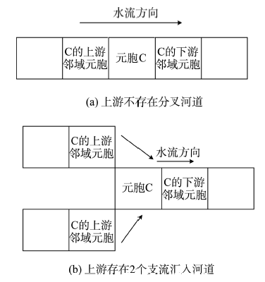
Fig. 1 Definition of the cellular neighborhood

图1 元胞邻域定义

2.4 转换规则构建

基于CA的河道汇流过程中转换规则主要用于描述元胞流量属性状态变化。元胞流量主要由坡面入流、邻域元胞入流、元胞自身存储流量、降雨量构成,其中降雨量可以从降雨情景数据中获取,而其他流量变化通过构建相应的规则进行获取,因此需要建立的转换规则有坡面产流计算规则与河道汇流计算规则(图2)。
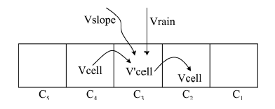
Fig. 2 Flow process of channel base on CA

图2 基于CA的河道汇流过程图

2.4.1 坡面产流计算规则
通过构建坡面产流计算规则,可以获取流入每个河道元胞的坡面入流量。以单个坡面单元为研究对象,产流过程由SCS-CN模型[17]计算。
F S = Q P - I a (3)
按水量平衡原理:
P = I a + F + Q (4)
经整理后,可用式(5)计算元胞上任一坡面径流深:
Q = P - I a 2 P - I a + S (5)
式中:S为土壤潜在最大滞蓄量/mm;Ia为降雨初损/mm;P为降雨量/mm;F为实际入渗量/mm。根据径流深Q及降雨时长t可计算净雨强度ic
i c = Q t (6)
坡面流流速用近似运动波动力方程和连续方程[18]来估算,因此对平稳流单个格网的坡面汇流时间t可以用运动波方程表示。
t = l 0.6 n 0.6 i c 0.4 s 0.3 (7)
式中:ic是净雨强度/(m/s);l是该坡面单元水流长 度/m;n是曼宁糙率系数;s是坡面单元的坡度 值/(m/m)。
2.4.2 河道汇流规则
河道汇流模型中局部转换规则用于描述水流在河道中流动过程,主要为上游河道元胞向下游流量分配过程。元胞中流量汇流模型由曼宁方程和连续方程[18]求得,计算公式为:
v = s 0.3 q 0.4 n 0.6 B 0.4 (8)
式中:s是单元坡度值/(m/m);q是汇流量/(m3/s);B是河道宽度/m;n为一级土地覆盖分类对应的曼宁粗糙系数。sBn作为元胞静态属性分别根据河道单元具体特征在构建元胞时写入到元胞属性中,q作为元胞动态属性,在计算过程中由坡面入流Vslope、上游元胞入流Vcell、元胞自身存储流量V′cell、降雨量Vrain计算得出。
q = V slope + V cell + V ' cell + V rain (9)
河道汇流过程中的水流流动为上游元胞向下游元胞的水流分配过程,为了避免计算时间步长对模拟结果产生影响,根据模拟时间间隔t内的水流长度与元胞长度进行比例换算得到流入下游元胞的流量 q
l ' = vt (10)
q = q l ' l , l ' l q ( l ' - nl ) l , l ' > l , 其中 n = l ' / l 向下取整 (11)
经过以上步骤建立了基于CA的河道汇流模型,具体实现算法流程图如图3所示。
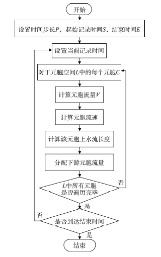
Fig. 3 Flow chart of concentration algorithm

图3 汇流算法流程图

2.5 模型实现

在ArcEngine平台下进行二次开发实现以上模型,主要设计功能有:河道元胞构建、河道等流时单元计算、坡面入流过程线计算、河道汇流计算(图4)。
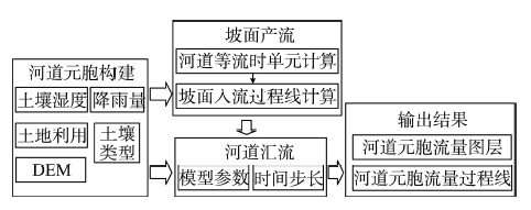
Fig. 4 Data process flow chart of the model

图4 各功能模块流程图

(1) 河道元胞构建:在获取研究区土地利用数据、土壤湿度、土壤类型、降雨数据的基础上构建河道元胞。构建的河道元胞具有曼宁糙率系数、坡面单元集合、水流流向、坡度、水流长度等属性。最终将构建的河道元胞在XML中表示。
(2) 河道等流时单元计算:传统意义上的等流时单元以出山口为基准,所有具有相同值的等流时单元到达出山口时间相同。河道单元的等流时单元以河道为基准,具有相同值的等流时单元流到其对应河道单元时间相同。根据元胞中的坡面汇流时间、汇流方向及坡面单元集合等属性数据可计算每个河道单元的坡面等流时单元。根据河道单元的等流时图层可以计算流入到河道元胞的坡面入流流量。
(3) 坡面入流过程线计算:在以上功能的基础上,利用每个河道元胞的坡面单元集合对河道等流时单元进行统计,获取每个河道元胞的坡面入流流量过程线。
(4) 河道汇流计算:在构建河道元胞,获取每个元胞对应坡面流量过程线的基础上,设定模型参数、模拟运行时间及时间步长,利用构建的河道汇流规则模拟河道水流过程,可以输出某一时间的所有河道元胞流量和具体某一河道元胞的流量过程线。

3 模型应用与分析

3.1 研究区概况及基本参数设置

茂林溪流域位于福建省厦门市同安区北部,发源于汪前村云顶山,最终汇入汀溪水库。流域地形主要为山地和丘陵,总面积为50.5 km2,高程为 80 ~ 1169.93 m,平均高程为502.78 m。土壤类型以红壤和水稻土为主,土地覆盖类型以林地和农业用地为主。本文选取该区域1997年5月6日至7日的降水事件作为模型验证的案例,并根据降雨时间分布特征进行了场次划分,并对每个场次引起的出山口河道断面洪峰流量进行了模拟。
实验数据包括:DEM数据、土地利用数据、土壤类型数据、降雨数据等(来自福省陆地灾害监测评估工程技术研究中心)。为了验证该模型的精度,便于与未使用CA情况下进行对比,模拟试验中所用数据格式与模型参数均参考了文献[19],模型参数均使用经验值。

3.2 计算结果及分析

图5为本文将CA模型与水文学方法相结合进行模拟的结果,图6为文献[19]仅使用水文学方法模拟的结果。在模拟数据与模型参数均相同情况下,将本文结果与文献[19]的结果进行对比分析:本次降雨模拟共引起4次洪峰,从图5表1中本文模拟结果可以看出第1、2、4次洪峰模拟结果洪峰流量均接近真实值,相对误差均在10%以内,峰现时差均小于10 min,模拟效果较好;在文献[19]模拟的结果中,第1次洪峰误差约为200%,未模拟出第2、3次洪峰,第4次洪峰相对误差为20.7%。第4次洪峰实测值为943 m3/s,为本次降雨模拟最大洪峰流量,本文模拟的洪峰流量为980 m3/s,相对误差为4%,峰现时差为360 s,文献[19]的模拟流量为748 m3/s,相对误差为20.7%,峰现时差约为0.5 h。综上,本文模拟结果相比文献[19]不仅模拟出每次降雨间隔产生的较小洪峰,并且在整场降雨产生的最大洪峰流量精度与时间精度上均提高了5倍。
Fig. 5 Discharge lines of measured value and simulated value in outlet cellular

图5 出山口实测流量与模拟流量对比

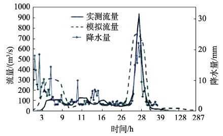
Fig. 6 Discharge lines of measured value and simulated value on May, 6-7th, 1997

图6 1997年5月6日至7日实测与模拟流量过程线[19]

Tab.1 Error of flood peak in outlet

表1 出山口洪峰流量误差表

洪峰序号 实测洪峰/(m3/s) 计算洪峰/(m3/s) 洪峰相对误差/% 峰现时差/s
1 107 109 2 600
2 127 114 10 800
3 102 188 84 700
4 943 980 4 360
本文第3次洪峰模拟误差较大,模型建立过程中将坡面流产流过程独立计算,假定同一降雨情景下坡面汇流过程中不存在净雨强度变化,未考虑坡面汇流过程中雨强变化对坡面流速的影响。在本次模拟过程中,5×104 ~ 6×10⁴ s产生较强降雨,坡面汇流过程中流速较大,6×104 ~ 8×10⁴ s雨强几乎为零,该时间内坡面汇流流速较小,而在本模型中将5×10⁴ ~ 6×10⁴ s产生的降雨始终使用原来的雨强进行计算,因此产生洪峰较大并且提前,而洪峰过后流量偏小。但本次降雨模拟的总体纳什系数为0.84,达到了精度要求。
利用CA模型不仅可以计算出河道中任意断面的流量还可以实现河道汇流可视化。根据河道中流量变化情况对洪水形成过程进行分析研究,从模拟的河道流量过程图中可以看出,河道中不同断面流量变化过程,从图7(a)中可以看出降雨初始阶段河道中上游和下游流量较小,中游流量相对增大,随着降雨的持续而在图7(b)、(c)中可以看出河道中流量增大,而中下游流量相对较大。
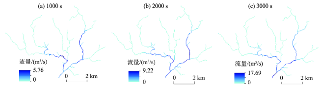
Fig.7 Distribution of simulated discharge in channels

图7 部分时刻模拟河道汇流流量

4 结论

本文利用元胞自动机基于简单的规则可以模拟复杂事物动态变化的优点,模拟了河道汇流过程。首先根据河道属性特征构建了河道元胞,利用SCS-CN模型构建坡面产流规则,计算了每个河道元胞上的坡面入流;然后利用曼宁方程构建河道汇流规则,模拟河道汇流过程;在ArcEngine平台下实现了河道汇流可视化。利用厦门市茂林溪流域1997年5月6日至7日的降雨径流数据进行模拟验证,将本文模拟结果与该流域其他学者的研究结果进行了对比分析,在输入数据与水文模型参数相同的情况下,本文模拟的最大洪峰流量精度与时间精度均提高了5倍,可以更准确地模拟河道汇流过程。
本文中通过建立河道坡面拓扑关系,计算每个河道元胞的坡面入流,而实际应用中无法对每个河道元胞的坡面产流汇流模型进行参数率定,因此获取的河道元胞上的坡面入流具有一定误差,该方面还需要进一步研究。

The authors have declared that no competing interests exist.

[1]
范世香. 水文学原理[M].北京:中国水利水电出版社,2014.

[ Fan S X.Principles of hydrology[M]. Beijing: Chinese Water & Power Press, 2014. ]

[2]
周成虎. 地理元胞自动机研究[M].北京:科学出版社,1999.

[ Zhou C H, Sun Z L, Xie Y C.Research of geographical cellular automata[M]. Beijing: Science Press, 1999. ]

[3]
汤富平,李满春,秦奋,等.基于CA的小流域分布式降雨径流模拟[J].水科学进展,2010,21(2):173-178.构建基于元胞自动机(CA)模型的分布式水文模型,模拟小流域内降雨径流过程。从元胞状态、转换规则与时间步长3个方面扩展普通CA模型,包括5个子状态、5个元胞系数及两条转换规则,并实现模型与GIS的集成。以黄土高原岔巴沟流域的降雨径流观测数据对模型进行了验证分析。试验结果表明,确定性系数、峰现时差与洪峰误差3个评价指数都达到一定精度,实现了流域内径流过程的可视化。结合CA模型与GIS技术可以较为有效地模拟流域次降雨径流过程,模型在该试验区是基本适用的。

[ Tang F P, Li M C, Qin F, et al.Distributed rainfall-runoff simulating based on cellular automata for small watersheds[J]. Advances in Water Science, 2010,21(2):173-178. ]

[4]
Shao Q, Weatherley D, Huang L, et al.RunCA: A cellular automata model for simulating surface runoff at different scales[J]. Journal of Hydrology, 2015,529:816-829.The Runoff Model Based on Cellular Automata (RunCA) has been developed to simulate surface runoff at different scales by integrating basic cellular automata (CA) rules with fundamental measureable hydraulic properties. In this model, a two-dimensional lattice composed of a series of rectangular cells was employed to cover the study area. Runoff production within each cell was simulated by determining the cell state (height) that consists of both cell elevation and water depth. The distribution of water flow among cells was determined by applying CA transition rules based on the minimization-of-difference algorithm and the calculated spatially varied flow velocities. RunCA was verified and validated by three steps. Good agreement with the analytical solution was achieved under simplified conditions in the first step. Then, results from runoff experiments on small laboratory plots (2m 1m) showed that the model was able to well predict the hydrographs, with the mean Nash utcliffe efficiency greater than 0.90. RunCA was also applied to a large scale site (Pine Glen Basin, USA) with data taken from literature. The predicted hydrograph agreed well with the measured results. Simulated flow maps in this basin also demonstrated the model capability in capturing both the spatial and temporal variations in the runoff process. Model sensitivity analysis results showed that the calculated total runoff and total infiltration were most sensitive to the input parameters representing the final steady infiltration rate at both scales. The Manning roughness coefficient and the setting of cell size did not affect the results much at the small plot scale, but had large influences at the large basin scale.

DOI

[5]
Mendicino G, Pedace J, Senatore A.Stability of an overland flow scheme in the framework of a fully coupled eco-hydrological model based on the macroscopic cellular automata approach[J]. Communications in Nonlinear Science and Numerical Simulation, 2015,21(1):128-146.Cellular Automata are often used for modeling the evolution in time of environmental systems mainly because they are directly compatible with parallel programming. Nevertheless, defining the optimal time step criterion for integrating forward in time numerical processes can further enhance model computational efficiency. To this aim, a numerical stability analysis of an original overland flow model, within the framework of a fully coupled eco-hydrological system based on the Macroscopic Cellular Automata paradigm, is performed. According to the other modules of the system describing soil water flow, soil-surface-atmosphere fluxes and vegetation dynamics, overland flow model equations were derived through a direct discrete formulation (i.e. no differential equations were discretized), adopting the diffusion wave model as an approximation of the full De Saint Venant equations and including the capability of accounting for specific processes, such as the increasing roughness effects due to vegetation growth or surface-soil water exchanges. Suitable formulations of robust tools usually applied in the stability analyses, such as Courant riedrichs ewy and von Neumann conditions, were initially derived for the CA-based overland flow model. Afterwards, the theoretical stability conditions were compared to experimental time step constraints through several numerical simulations of a 5-h rain event. Specifically, adopting a constant (i.e. not adaptive) time step for simulations, and discretizing head losses in a way that increases model stability, experimental upper limits preventing numerical instability were found for 13 test cases with different slopes, precipitation intensities, vegetation densities and depths of surface depressions. Even though von Neumann condition and experimental values were well positively correlated, the latter were almost always sensibly lower, excluding cases when free surface gradients tended to zero. Therefore, based on the original method, two alternative criteria were developed. Numerical tests showed that the joint use of these criteria greatly helps in finding the optimal time steps for convergent and stable simulations of the overland flow model.

DOI

[6]
李宗花,叶正伟.基于元胞自动机的洪泽湖洪水蔓延模型研究[J].计算机应用,2007,27(3):718-720.Basic principle and structure of Cellular Automata (CA) was analyzed, and flood spreading model of Hongze Lake was established by making use of CA rule. Based on grid spatial data structure, adopting the two-dimensional CA model, the cellular space and cellular states were established, and the rule for flood spreading modeling was made. The update of the cellular sate acted according to the rule of 9 neighbors. The computed data by choosing typical index was tested. The results show that two-dimensional CA model can model the flood spreading process more simply and faster.

[ Li Z H, Ye Z W.Study on flood spreading model of Hong ze Lake based on cellular automata[J]. Journal of Computer Applications, 2007,27(3):718-720. ]

[7]
蔡新,李益,吴威,等.基于体积法思想的洪水淹没元胞自动机模型[J].水力发电学报,2013,32(5):30-34.针对体积法中存在的计算循环次 数多、用时长、不能较好反映洪水淹没时空特性的问题,在体积法思想基础上,引入元胞自动机理论,构建了基于体积法思想的洪水淹没模拟元胞自动机模型。较为 详细地阐述了所建立模型中溃口流量、计算时间步长、淹没流量以及淹没水位的计算方法,并对长江荆江段进行了实例模拟。结果表明元胞自动机模型能够较好地反 映洪水淹没的时空特性,可为堤防工程防洪减灾预警与应急决策提供参考。

[ Cai X, Li Y, Wu W, et al.Cellular automaton model of flood submergence based on bulk method[J]. Journal of Hydroelectric Engineering, 2013,32(5):30-34. ]

[8]
钟燃,朱军,李毅,等.基于层次分析法的泄洪区选址及模拟分析研究[J].自然灾害学报,2013,22(4):82-91.

[ Zhong R, Zhu J, Li Y, et al.AHP-based site selection of flood discharge zones and simulation analysis[J]. Journal of Natural Disasters, 2013,22(4):82-91. ]

[9]
Ghimire B, Chen A S, Guidolin M, et al.Formulation of a fast 2D urban pluvial flood model using a cellular automata approach[J]. Journal of Hydroinformatics, 2013,15(3):676-686.ABSTRACT With the increase in frequency and severity of flash flood events in major cities around the world, the infrastructure and people living in those urban areas are exposed continuously to high risk levels of pluvial flooding. The situation is likely to be exacerbated by the potential impact of future climate change. A fast flood model could be very useful for flood risk analysis. One-dimensional (1D) models provide limited information about the flow dynamics whereas two-dimensional (2D) models require substantial computational time and cost, a factor that limits their use. This paper presents an alternative approach using cellular automata (CA) for 2D modelling. The model uses regular grid cells as a discrete space for the CA setup and applies generic rules to local neighbourhood cells to simulate the spatio-temporal evolution of pluvial flooding. The proposed CA model is applied to a hypothetical terrain and a real urban area. The synchronous state updating rule and inherent nature of the proposed model contributes to a great reduction in computational time. The results are compared with a hydraulic model and good agreement is found between the two models.

DOI

[10]
Liu L, Liu Y, Wang X, et al.Developing an effective 2-D urban flood inundation model for city emergency management based on cellular automata[J]. Natural Hazards & Earth System Sciences, 2014,2(3):6173-6199.Flash floods have occurred frequently in the urban areas of southern China. An effective process-oriented urban flood inundation model is urgently needed for urban storm-water and emergency management. This study develops an efficient and flexible cellular automaton (CA) model to simulate storm-water runoff and the flood inundation process during extreme storm events. The process of infiltration, inlets discharge and flow dynamics can be simulated with little preprocessing on commonly available basic urban geographic data. In this model, a set of gravitational diverging rules are implemented to govern the water flow in a rectangular template of three cells by three cells of a raster layer. The model is calibrated by one storm event and validated by another in a small urban catchment in Guangzhou of southern China. The depth of accumulated water at the catchment outlet is interpreted from street-monitoring closed-circuit television (CCTV) videos and verified by on-site survey. A good level of agreement between the simulated process and the reality is reached for both storm events. The model reproduces the changing extent and depth of flooded areas at the catchment outlet with an accuracy of 4 cm in water depth. Comparisons with a physically based 2-D model (FloodMap) show that the model is capable of effectively simulating flow dynamics. The high computational efficiency of the CA model can meet the needs of city emergency management.

DOI

[11]
赖泽辉,包世泰,陈顺清,等.基于元胞自动机的城市地表积水模拟研究[J].水土保持通报,2015,35(6):182-186.目的]对城市地表水文产汇流时空过程进行模拟研究,以期为城市排水防涝应急决策提供依据.[方法]针对城市地表覆盖破碎性和地形复杂性的特征,构建基于元胞自动机(CA)的城市地表积水模型,结合水力水文学原理定义元胞及其规则.[结果]与传统统计经验模型、物理模型相比,该模型避免了汇水区划分、水流路径确定、参数提取等数据预处理问题,以广州市番禺区富华东路段区域作为试验区进行参数率定及模型验证,根据规则更新每个元胞的状态参数可获得任意时刻地表积水量、径流量和水流.[结论]该CA模型可以准确模拟地表水流时空分布及其变化,模拟结果可靠、表达直观;通过雨水口不同排放量模拟和常用数学模型对比分析表明,CA城市地表积水模型在城市内涝模拟中具有良好的实用性及易操作性.

[Lai Z H, Bao S T, Chen S Q, et al. An urban surface flooding modeling based on cellular automata[J]. Bulletin of Soil and Water Conservation, 2015,35(6):182-186. ]

[12]
刘星飞,原立峰,吴淑芳,等.不同空间尺度下的土壤侵蚀元胞自动机建模评述[J].中国水土保持科学,2012,10(4):113-120.土壤侵蚀系统是一个典型的非线性动力系统,系统内部的侵蚀发育演化过程十分复杂,为了对该过程进行精确的模拟和预测,需要发展有效的技术和方法。元胞自动机(cellular automata,CA)是一种具有时空特征的离散动力学模型,采用&ldquo;自下而上&rdquo;的构模方式,对于模拟和分析具有空间特征的土壤侵蚀系统具有先天优势。由于空间尺度变化所引起的土壤侵蚀因子对侵蚀产沙过程的影响不同,CA 模型在坡面尺度下主要针对细沟侵蚀和土壤颗粒的变化,在小流域尺度下涉及到更多的元胞状态和更加完整的侵蚀过程,在大区域尺度下重点研究气候和地貌之间的相互作用。不同空间尺度建立的CA 模型没有确定的转换规则,模型通用性较低,今后需要在三维可视化、智能化等方面深入研究CA 模型在土壤侵蚀领域的应用。

[ Liu X F, Yuan L F, Wu S F, et al.Review of soil erosion modeling using Cellular Automata in different spatial scales[J]. Science of Soil and Water Conservation, 2012,10(4):113-120. ]

[13]
曹敏,汤国安,张芳,等.基于元胞自动机的黄土小流域地形演变模拟[J].农业工程学报,2012,28(22):149-155.黄土高原以沟沿线为基准分为正地形和负地形2种基本的地貌形态,黄土小流域正负地形演变是黄土高原地貌形态发育的缩影。该文采用元胞自动机建模方法,对人工降雨条件下室内黄土小流域正负地形的动态演变过程进行建模与模拟。试验使用近景摄影测量方法监测小流域发育过程,处理获得10mm分辨率的数字高程模型。模拟迭代过程逼真地刻画了黄土负地形区向正地形区不断蚕食的动态演化过程,并能反映出非常重要的黄土陷穴现象的发生。模拟结果在数量上和空间分布上都取得了较好的模拟效果。研究认为元胞自动机建模方法可以用来模拟黄土小流域的正负地形演变,有助于揭示黄土地形演化机制。

DOI

[ Cao M, Tang G A, Zhang F, et al. Simulation of terrain evolution in small loess watershed based on cellular automata[J]. Transactions of the Chinese Society of Agricultural Engineering, 2012,28(22):149-155. ]

[14]
Heung B, Bakker L, Schmidt M G, et al.Modeling the dynamics of soil redistribution induced by sheet erosion using the Universal Soil Loss Equation and cellular automata[J]. Geoderma, 2013,202:112-125.As a landscape changes, so do the flows of matter that run across it. These flows modify the landscape and can thereby alter their own course in a feedback mechanism. This study focuses on one instance of this process: medium-term background soil redistribution induced by sheet erosion. Previous studies that have modelled this phenomenon have either focused exclusively on a feedback loop, or have not included it at all. We incorporate all relevant soil-environmental variables, including a feedback loop, into a single model. A unique feature of the proposed model is in the handling of the fluvial sediment flux (q(s)), which may be determined from the Universal Soil Loss Equation (USLE). The USLE itself does not explicitly incorporate a feedback loop, but can readily be made to incorporate it by calculating a new, spatially distributed value for qs at each time step in response to topographical changes. Hence, the objective of this study was to develop a soil redistribution model that considers q(s) as being both spatially distributed and temporally dynamic.Rainfall erosivity was derived from mean annual precipitation, vegetation cover from satellite imagery, and slope characteristics from a DEM; in addition, soil erodibility values were derived from legacy soil survey data. The developed model was tested on Bowen Island, British Columbia, Canada at a 25 m spatial resolution. Soil redistribution simulations were made for 100 years, where 95% of the soil depth change was between a 3.01 cm loss and a 2.40 cm accumulation. The model was tested in order to assess the effects of different flow routing algorithms, resolutions, and soil deposition regimes on soil redistribution. Incorporating a feedback loop into the model yielded a disproportionate effect on soil redistribution; hence, small changes in the model state resulted in effects that are several orders of magnitude larger than the original change. (C) 2013 Elsevier B.V. All rights reserved.

DOI

[15]
王伟,李欣,陈能成,等.利用元胞自动机计算河道槽蓄量[J].武汉大学学报·信息科学版,2013,38(2):235-239.构建基于元胞自动机的河道水流漫延模型,在该模型中针对河道地形特点处理边界问题,基于水力学中的曼宁公式构建模型局部转换规则,并利用元胞自动机的模拟空间复杂系统动态演变能力的特点,模拟了水流由上断面向下断面流动的动态过程,形成符合上下断面水位的水面,进而计算河道槽蓄量.实验结果表明,把元胞自动机模型引入水文领域计算河道槽蓄量的方法具有可行性.

[ Wang W, Li X, Chen N C, et al.Computing river storage based on cellular automata[J]. Geomatics and Information Science of Wuhan University, 2013,38(2):235-239. ]

[16]
周成虎,欧阳,马廷,等.地理系统模拟的CA模型理论探讨[J].地理科学进展,2009,28(6):833-838.在系统认识和理解地理元胞自动 机(CA)模型的基本性质基础上,重点从自然与人文综合的复杂地理系统模拟研究角度,对地理元胞模型所涉及的基本理论与方法问题进行了进一步的探讨。研究 表明:从地理系统的模拟看,CA模型的研究和应用提供了一种从地理系统的微观出发、将自然与人文统一的地理系统模拟的新视角与新途径。在此基础上,提出了 地理系统模拟的CA模型需要解决的三队基本关系和三个基本科学方法问题。

DOI

[ Zhou C H, Ou Y, Ma T, et al, Theoretical perspectives of CA-based geographical system modeling[J]. Progress in Geography, 2009,28(6):833-838. ]

[17]
刘家福,蒋卫国,占文凤,等.SCS模型及其研究进展[J].水土保持研究,2010,17(2):120-124.流域水文模型主要用于模拟流域上发生的水文过程,美国水土保持局提出的SCS模型是目前广泛应用的地表径流模型之一。SCS模型具有结构简单、所需参数少、对观测数据的要求不严格等特点,能够客观描述不同土地利用方式、土壤类型、前期土壤含水量及降水条件下的地表径流过程,对于小面积集水区径流预报具有较强的能力。介绍了SCS模型的基本原理,从模型应用、发展与改进等角度对SCS模型的研究进行了回顾与总结。指出了SCS模型在时空尺度、预报精度等方面尚存的问题。最后,对SCS模型的发展趋势进行了展望,以期为我国的地表径流研究提供借鉴。

[ Liu J F, Jiang W G, Zhan W F, et al.Processes of SCS model for hydrological simulation : A review[J]. Research of Soil and Water Conservation, 2010,17(2):120-124. ]

[18]
Melesse A M, Graham W D.Storm runoff prediction based on a spatially distributed travel time method utilizing remote sensing and GIS[J]. Journal of the American Water Resources Association, 2004,40(4):863-879.ABSTRACT: In this study, remotely sensed data and geographic information system (GIS) tools were used to estimate storm runoff response for Simms Creek watershed in the Etonia basin in northeast Florida. Land cover information from digital orthophoto quarter quadrangles (DOQQ), and enhanced thematic mapper plus (ETM+) were analyzed for the years 1990, 1995, and 2000. The corresponding infiltration excess runoff response of the study area was estimated using the U.S. Department of Agriculture (USDA), Natural Resources Conservation Service Curve Number (NRCS-CN) method. A digital elevation model (DEM)/GIS technique was developed to predict stream response to runoff events based on the travel time from each grid cell to the watershed outlet. A comparison of predicted to observed stream response shows that the model predicts the total runoff volume with an efficiency of 0.98, the peak flow rate at an efficiency of 0.85, and the full direct runoff hydrograph with an average efficiency of 0.65. The DEM/GIS travel time model can be used to predict the runoff response of ungaged watersheds and is useful for predicting runoff hydrographs resulting from proposed large scale changes in the land use.

DOI

[19]
陈俊明. 基于情景模拟的小山洪灾害预警方法研究与系统实现[D].福州:福建师范大学,2012.

[ Chen J M, A flash flood disaster warning system based on scenarios simulation[D]. Fuzhou: Fujian Normal University, 2012. ]

文章导航

/