
1974-2017年山东省大陆海岸围填海动态变化分析
|
宫 萌(1995-),女,山东威海人,硕士生,研究方向为海岸带资源开发与规划管理。E-mail: mgong@yic.ac.cn |
收稿日期: 2019-04-16
要求修回日期: 2019-09-09
网络出版日期: 2019-12-25
基金资助
中国科学院重点部署项目资助(KZZD-EW-14)
中国科学院战略性先导科技专项(A类)资助(XDA11020305)
版权
Reclamation Dynamics Along the Mainland Coast of Shandong Province during 1974-2017
Received date: 2019-04-16
Request revised date: 2019-09-09
Online published: 2019-12-25
Supported by
Key Project of the Chinese Academy of Sciences(KZZD-EW-14)
Strategic Priority Research Program of the Chinese Academy of Sciences(XDA11020305)
Copyright
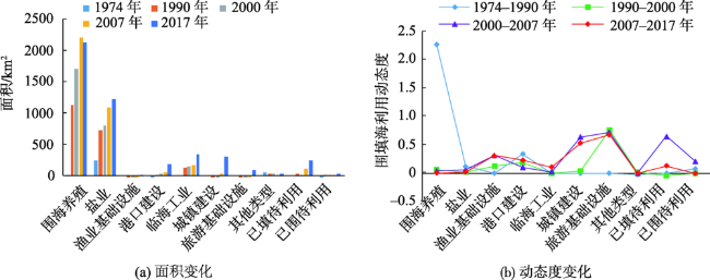
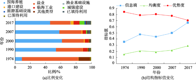
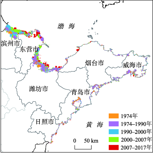
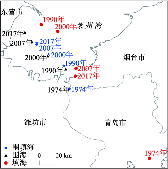
围填海是沿海地区解决土地资源短缺的重要手段,及时准确地监测地区围填海时空动态变化对于合理保护海岸带资源和推进地区社会经济可持续发展具有重要意义。本文基于遥感、GIS技术,结合多种数据源,提取并分析1974-2017年山东省大陆海岸围填海时空动态变化特征。结果表明,43年来山东省大陆海岸围填海面积持续增长,到2017年总面积达到4649.26 km 2,围海为主要利用方式。围海活动多分布于黄河三角洲及莱州湾滩涂海域,填海活动则集中分布于沿海各大港口海域和城市滨海区域。全省围填海呈现出明显的阶段性特征,特别是2000年后,填海造地面积增加迅速,围海利用向填海造地转换现象突出,主要用于港口及临港产业发展和城镇与旅游基础设施建设,受沿海地区发展战略和城镇化、工业化驱动明显,围填海利用向综合化、多元化和集中集约化发展。
宫萌 , 吴晓青 , 于璐 . 1974-2017年山东省大陆海岸围填海动态变化分析[J]. 地球信息科学学报, 2019 , 21(12) : 1911 -1822 . DOI: 10.12082/dqxxkx.2019.190175
With the rapid socioeconomic development, human activities continue to expand from mainland toward the sea. In this context, reclamation has become an important way to solve the shortage of land resources in coastal areas. However, high-intensity and unreasonable reclamation has caused tremendous pressure on the eco-environment in the coastal zone. Timely and accurately monitoring regional reclamation is of great significance for the protection of coastal resources and the promotion of regional sustainable development. Shandong Province is a major marine province with a long history of reclamation, with prominent coastal eco-environment problems caused by reclamation. By summarizing the existing literature, we found that there are few studies focused on unraveling the human-environmetal laws of reclamation, especially in Shandong province. So we extracted the vector data of reclamation using remote sensing images, and analyzed the spatiotemporal dynamics along the mainland coast of Shandong Province from 1974 to 2017. The present study was based on RS/GIS technology, combined with a variety of data sources and aiming to inform reclamation management and related planning of the coastal zone in the study area. Results showed that: (1) The reclamation area of the mainland coast of Shandong Province had reached 4649.26 km 2 by 2017, presenting a sustained growth trend during the research period. The main type of utilization was sea-based reclamation. (2) Sea-based reclamation was mainly distributed in the Yellow River delta and the tidal flat areas of Laizhou Bay, while land-based reclamation was concentrated in the coastal areas of major ports and cities. The gravity center of reclamation moved from southeast to northwest during 1974-2017. (3) Frequent conversion from sea-based reclamation to land-based reclamation was prominent, and reclamation utilization types changed from being single to more diversified. The proportion of harbors, towns, industries, and other utilization types in reclamation development had increased rapidly, and the development of aquaculture and salt industry was no longer the main way. The reclamation utilization turned to be more comprehensive, diversified, and intensified. (4) Coastal reclamation in the whole province presented obvious multi-stage characteristics. Before 2000, reclamation in Shandong Province was mainly used to develop aquaculture and salt industry. While after 2000, especially from 2007 to 2017, the land-based reclamation area had increased rapidly, mainly used for port construction, urban and tourism infrastructure construction, and industrial development of coastal ports, due to the impact of the coastal development strategy, urbanization and industrialization. (5) The types of reclamation had been transformed between each other frequently. The new land in Shandong Province came not only from land reclamation to the sea, but also from the transformation of original reclamation types such as aquaculture ponds and salt fields.
表1 围填海利用类型分类及其内涵Tab. 1 Different reclamation utilization types and connotations |
| 分类 | 说明 |
|---|---|
| 围海养殖 盐业 渔业基础设施 港口建设 临海工业 城镇建设 旅游基础设施 其他类型 已填待利用 已围待利用 | 指筑堤围割海域进行封闭或半封闭式养殖生产的围海 指用于盐业生产的围填海,包括盐田、盐场等 指用于渔船停靠、进行装卸作业和避风,以及用以繁殖重要苗种的围填海 指供船舶停靠、装卸作业、避风和调动等所使用的围填海,如开敞式的货运和客运码头 指用于开展工业生产所使用的围填海,包括船舶工业、电力工业等 指通过筑堤围割海域,填成土地后用于城镇(含工业园区、公园等)建设的围填海 指为满足娱乐活动需要而建设的配套工程设施所使用的围填海 指用于其他用途的围填海,包括海岸防护工程、水库等 指正在建设或已填未开发利用的填海活动 指正在建设或已围未开发利用的围海活动 |
表2 不同时间段山东大陆海岸新增填海造地来源Tab. 2 Sources of newly reclaimed land along the Shandong mainland coast in different time periods |
| 时段/年 | 新增填海/km2 | 围海转向填海 | 占比/% | |
|---|---|---|---|---|
| 面积/km2 | 速度/(km2/a) | |||
| 1974-1990 | 169.49 | 2.19 | 0.14 | 1.29 |
| 1990-2000 | 67.85 | 45.31 | 4.53 | 66.78 |
| 2000-2007 | 210.05 | 104.01 | 14.86 | 49.52 |
| 2007-2017 | 786.33 | 582.83 | 58.28 | 74.12 |
| [1] |
|
| [2] |
徐谅慧, 杨磊, 李佳林 , 等. 1990-2010年浙江省围填海空间格局分析[J]. 海洋通报, 2015,34(6):688-694.
[
|
| [3] |
柯丽娜, 曹君, 武红庆 , 等. 基于多源遥感影像的锦州湾附近海域围填海动态演变分析[J]. 资源科学, 2018,40(8):1645-1657.
[
|
| [4] |
雷宁, 胡小颖, 周兴华 . 胶州湾围填海的演进过程及其生态环境影响分析[J]. 海洋环境科学, 2013,32(4):506-509.
[
|
| [5] |
王伟伟, 王鹏, 郑倩 , 等. 辽宁省围填海海洋开发活动对海岸带生态环境的影响[J]. 海洋环境科学, 2010,29(6):927-929.
[
|
| [6] |
刘述锡, 马玉艳, 卞正和 . 围填海生态环境效应评价方法研究[J]. 海洋通报, 2010,29(6):707-711.
[
|
| [7] |
鞠明明, 汪闽, 张东 , 等. 基于面向对象图像分析技术的围填海用海工程遥感检测[J]. 海洋通报, 2013,32(6):678-684.
[
|
| [8] |
温礼, 吴海平, 姜方方 , 等. 基于高分辨率遥感影像的围填海图斑监测分类体系和解译标志的建立[J]. 国土资源遥感, 2016,28(1):172-177.
[
|
| [9] |
温礼, 吴海平, 姜方方 , 等. 高分遥感影像的围填海变化图斑自动提取方法[J]. 测绘科学, 2015,41(6):42-45,76.
[
|
| [10] |
朱丽丽, 邵峰晶, 王常颖 , 等. 基于数据挖掘的遥感影像围填海智能检测方法研究[J]. 青岛大学学报(自然科学版), 2012,25(2):53-57,66.
[
|
| [11] |
李治, 杜云艳, 杨晓梅 , 等. 海岸工程变化的BJ-1遥感监测分析[J]. 地球信息科学报, 2012,14(4):540-547.
[
|
| [12] |
陈凤桂, 吴耀建, 陈斯婷 . 福建省围填海发展趋势及驱动机制研究[J]. 中国土地科学, 2012,26(5):23-29.
[
|
| [13] |
黄杰, 索安宁, 孙家文 , 等. 中国大规模围填海造地的驱动机制及需求预测模型[J]. 大连海事大学学报( 社会科学版), 2016,15(2):13-18.
[
|
| [14] |
宋红丽, 刘兴土 . 围填海活动对我国河口三角洲湿地的影响[J]. 湿地科学, 2013,11(2):297-304.
[
|
| [15] |
马田田, 梁晨, 李晓文 , 等. 围填海活动对中国滨海湿地影响的定量评估[J]. 湿地科学, 2015,13(6):653-659.
[
|
| [16] |
张雨 . 中国沿海围填海管控分区方案研究[D]. 天津:天津师范大学, 2017.
[
|
| [17] |
陈甫源, 王琪, 曾剑 , 等. 浙江省海岸线分类保护与围填海分类管理[J]. 海洋开发与管理, 2018,35(6):62-65,70.
[
|
| [18] |
黄发明, 于东升, 王初升 . 海湾围填海强度指数的应用[J]. 亚热带资源与环境学报, 2013,8(3):10-14.
[
|
| [19] |
安国强 . 基于多源数据的山东省围填海造地特点及发展趋势研究[J]. 海洋开发与管理, 2018,3(3):15-20.
[
|
| [20] |
靳宇弯, 杨薇, 孙涛 , 等. 围填海活动对黄河三角洲滨海湿地生态系统的影响评估[J]. 湿地科学, 2015,13(6):682-689.
[
|
| [21] |
田艳, 于定勇, 李云路 . 莱州湾围填海工程对海洋环境的累积影响研究[J]. 中国海洋大学学报, 2018,48(1):117-124.
[
|
| [22] |
|
| [23] |
HY/T 123-2009 海域使用分类[S]. 北京: 标准出版社, 2009.
[ HY/T 123-2009 Sea area use classification[S]. Beijing: Standards Press of China, 2009. ]
|
| [24] |
GB/T 21010-2017 土地利用现状分类[S]. 北京: 标准出版社, 2007.
[ GB/T21010-2017 Current land use condition classification[S]. Beijing: Standards Press of China, 2007. ]
|
| [25] |
柯丽娜, 庞琳, 王权明 , 等. 围填海景观格局演变及存量资源分析——以大连长兴岛附近海域为例[J]. 生态学报, 2018,38(15):5498-5508.
[
|
| [26] |
刘敬财, 周宝同, 赵昆昆 , 等. 基于信息熵的土地利用结构变化影响因素分析——以重庆市丰都县为例[J]. 中国农学通报, 2011,27(32):221-225.
[
|
| [27] |
王德智, 邱彭华, 方源敏 , 等. 海口市海岸带土地利用时空格局变化分析[J]. 地球信息科学报, 2014,16(6):933-940.
[
|
| [28] |
柯丽娜, 董颖娜, 庞琳 , 等. 1995-2015年锦州湾海域围填海空间格局变化分析[J]. 海洋环境科学, 2018,37(3):389-395.
[
|
| [29] |
黄鹄, 戴志军, 胡自宁 , 等. 广西海岸环境脆弱性研究[M]. 北京: 海洋出版社, 2005.
[
|
| [30] |
张翠萍, 谢健, 娄全胜 , 等. 广东省填海造地的发展经验及对策研究[J]. 海洋环境科学, 2013,32(2):311-315.
[
|
| [31] |
谢丽, 王芳, 刘慧 . 广东省围填海历程及其环境影响研究[J]. 江苏科技信息, 2015(24):67-70.
[
|
| [32] |
付元宾, 曹可, 王飞 , 等. 围填海强度与潜力定量评价方法初探[J]. 海洋开发与管理, 2010,27(1):27-30.
[
|
| [33] |
马万栋, 吴传庆, 殷守敬 , 等. 辽宁省岸线及围填海变化分析[J]. 环境与可持续发展, 2014,39(6):54-57.
[
|
/
| 〈 |
|
〉 |


