
多模态地理大数据时空分析方法
|
邓 敏(1974— ),男,江西临川人,教授,博士生导师,从事时空数据挖掘与信息服务研究。E-mail:dengmin@csu.edu.cn |
收稿日期: 2019-09-04
要求修回日期: 2019-11-25
网络出版日期: 2020-04-08
基金资助
国家自然科学基金重点项目(41730105)
国家重点研发计划项目(2016YFB0502303)
版权
Spatio-temporal Analysis Methods for Multi-modal Geographic Big Data
Received date: 2019-09-04
Request revised date: 2019-11-25
Online published: 2020-04-08
Supported by
National Natural Science Foundation of China(41730105)
National Key Research and Development Foundation of China(2016YFB0502303)
Copyright
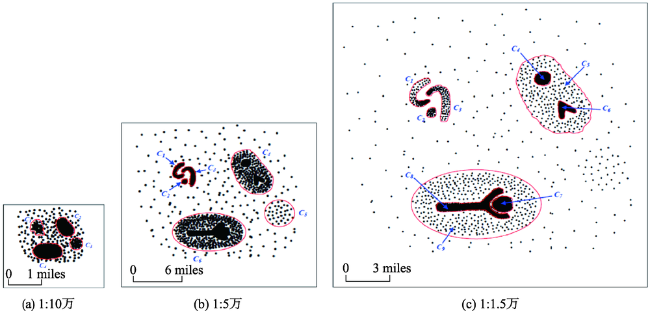
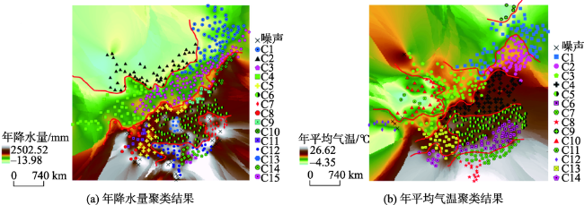
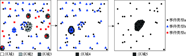
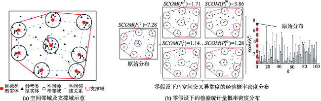
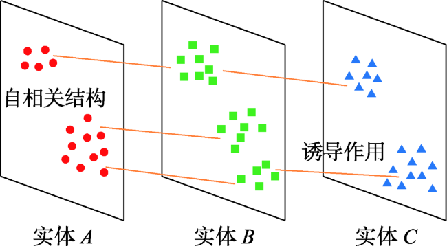
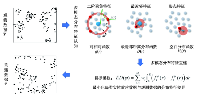
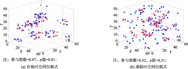
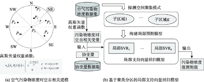
多模态地理大数据时空分析旨在融合地理大数据的多模态信息发现有价值的时空分布规律、异常表现、关联模式与变化趋势,是全空间信息系统的核心研究内容,并有望成为推进地理学人地关系研究的重要突破口。为应对地理大数据时代的新机遇与挑战,本文围绕4类核心的时空分析方法(时空聚类分析、时空异常分析、时空关联分析与时空预测分析),系统归纳了国内外研究现状,探讨了时空分析中多尺度建模、多视角协同、多特征认知与多特性表达的研究难点。进而,介绍了多模态地理大数据时空聚类、异常、关联与预测分析模型,更加全面、客观、精准地认知与理解时空大数据中潜在的地理知识,并且能够在气象环境监测、公共安全管理、城市设施规划等多个应用领域发挥关键作用。

邓敏 , 蔡建南 , 杨文涛 , 唐建波 , 杨学习 , 刘启亮 , 石岩 . 多模态地理大数据时空分析方法[J]. 地球信息科学学报, 2020 , 22(1) : 41 -56 . DOI: 10.12082/dqxxkx.2020.190491
Multi-modal spatio-temporal analysis is aimed at discovering valuable knowledge about the spatio-temporal distributions, associations and revolutions underlying the multi-modal geographic big data. It is a core task of the pan-spatial information system, and is expected to facilitate the study of relationship between human and space. With emerging opportunities and challenges in an era of geographic big data, we systematically summarized four main methods for spatial-temporal analysis based on previous study, including spatio-temporal cluster analysis, spatio-temporal outlier detection, spatio-temporal association mining and spatio-temporal prediction. We discussed the challenges when applying the four methods in multi-scale modeling, multi-view fusion, multi-characteristic cognition, and multi-characteristic expression for spatial-temporal analysis. First, two types of scales (including data scale and analysis scale) are of great importance in the spatio-temporal clustering task. Given the data scale, the best analysis scale for detecting spatio-temporal clusters can be determined using a permutation test method by evaluating the significance of clusters. Second, in the spatio-temporal outlier detection method, the cross-outliers in the context of two types of points are known as the abnormal associations between different types of points and the validity of cross-outliers is assessed through significance tests under the null hypothesis of complete spatial randomness. Third, in the spatio-temporal association mining method, the multi-modal distribution characteristics of each feature quantitatively described in the observed dataset are employed to construct the null hypothesis that the spatio-temporal distributions of different features are independent of each other, and then the evaluation of spatio-temporal associations is modeled as a significance test problem under the null hypothesis of independence. Finally, in the spatio-temporal prediction model, the effects of multiple characteristics of spatio-temporal data (e.g., spatio-temporal auto-correlation and heterogeneity) on the prediction results are fully considered using a space-time support vector regression model. These methods can reveal the geographic knowledge in a more comprehensive, objective, and accurate way, and play a key role in supporting the smart city applications, such as meteorological and environmental monitoring, public safety management, and urban facility planning. For example, the spatio-temporal clustering method can be used to identify the meteorological division, the spatio-temporal outliers can contribute to the detection of the abnormal distribution of urban facilities, the spatio-temporal association mining method can help discover and understand the relationship among different types of crimes, and the spatio-temporal prediction method can be employed to predict the concentration of air pollutants.
| [1] |
|
| [2] |
|
| [3] |
|
| [4] |
|
| [5] |
傅伯杰, 冷疏影, 宋长青 . 新时期地理学的特征与任务[J]. 地理科学, 2015,35(8):939-945.
[
|
| [6] |
|
| [7] |
|
| [8] |
朱庆, 付萧 . 多模态时空大数据可视分析方法综述[J]. 测绘学报, 2017,46(10):1672-1677.
[
|
| [9] |
杨振山, 龙瀛,
[
|
| [10] |
华一新, 周成虎 . 面向全空间信息系统的多粒度时空对象数据模型描述框架[J]. 地球信息科学学报, 2017,19(9):1142-1149.
[
|
| [11] |
裴韬, 刘亚溪, 郭思慧 , 等. 地理大数据挖掘的本质[J]. 地理学报, 2019,74(3):586-598.
[
|
| [12] |
周成虎 . 全空间地理信息系统展望[J]. 地理科学进展, 2015,34(2):129-131.
[
|
| [13] |
华一新 . 全空间信息系统的核心问题和关键技术[J]. 测绘科学技术学报, 2016,33(4):331-335.
[
|
| [14] |
宋长青 . 地理学研究范式的思考[J]. 地理科学进展, 2016,35(1):1-3.
[
|
| [15] |
李德仁, 王树良, 史文中 , 等. 论空间数据挖掘和知识发现[J]. 武汉大学学报·信息科学版, 2001,26(6):491-499.
[
|
| [16] |
李德仁, 王树良, 李德毅 , 等. 论空间数据挖掘和知识发现的理论与方法[J]. 武汉大学学报·信息科学版, 2002,27(3):221-233.
[
|
| [17] |
王劲峰, 葛咏, 李连发 , 等. 地理学时空数据分析方法[J]. 地理学报, 2014,69(9):1326-1345.
[
|
| [18] |
|
| [19] |
何占军, 邓敏, 蔡建南 , 等. 顾及背景知识的多事件序列关联规则挖掘方法[J]. 武汉大学学报·信息科学版, 2018,43(5):766-772.
[
|
| [20] |
|
| [21] |
|
| [22] |
邓敏, 刘启亮, 李光强 , 等. 空间聚类分析及应用[M]. 北京: 科学出版社, 2011.
[
|
| [23] |
|
| [24] |
|
| [25] |
|
| [26] |
|
| [27] |
|
| [28] |
|
| [29] |
汪中, 刘贵全, 陈恩红 . 一种优化初始中心点的K-means算法[J]. 模式识别与人工智能, 2009,22(2):299-304.
[
|
| [30] |
|
| [31] |
|
| [32] |
焦利民, 张欣, 毛立凡 . 自组织双重空间聚类算法的城市扩张结构分析应用[J]. 地球信息科学学报, 2015,17(6):638-643.
[
|
| [33] |
|
| [34] |
|
| [35] |
石岩, 刘启亮, 邓敏 , 等. 融合图论与密度思想的混合空间聚类方法[J]. 武汉大学学报·信息科学版, 2012,37(11):1276-1280.
[
|
| [36] |
|
| [37] |
|
| [38] |
吉根林, 孙鸿艳, 赵斌 . 时空轨迹群体运动模式挖掘研究进展[J]. 南京航空航天大学学报, 2016,48(5):615-624.
[
|
| [39] |
龚玺, 裴韬, 孙嘉 , 等. 时空轨迹聚类方法研究进展[J]. 地理科学进展, 2011,30(5):522-534.
[
|
| [40] |
刘文凯, 唐建波, 蔡建南 , 等. 面向城市交通应用的移动对象聚类算法比较研究[J]. 地理与地理信息科学, 2016,32(6):69-74.
[
|
| [41] |
|
| [42] |
邓敏, 石岩, 龚健雅 , 等. 时空异常探测方法研究综述[J]. 地理与地理信息科学, 2016,32(6):43-50.
[
|
| [43] |
|
| [44] |
|
| [45] |
|
| [46] |
|
| [47] |
|
| [48] |
|
| [49] |
|
| [50] |
|
| [51] |
|
| [52] |
邓敏, 刘启亮, 李光强 . 采用聚类技术探测空间异常[J]. 遥感学报, 2010,14(5):944-958.
[
|
| [53] |
|
| [54] |
|
| [55] |
|
| [56] |
毛嘉莉, 金澈清, 章志刚 , 等. 轨迹大数据异常检测:研究进展及系统框架[J]. 软件学报, 2017,28(1):17-34.
[
|
| [57] |
|
| [58] |
|
| [59] |
刘启亮, 邓敏, 王佳璆 , 等. 时空一体化框架下时空异常探测[J]. 遥感学报, 2011,15(3):457-474.
[
|
| [60] |
|
| [61] |
|
| [62] |
|
| [63] |
|
| [64] |
|
| [65] |
|
| [66] |
|
| [67] |
|
| [68] |
|
| [69] |
|
| [70] |
|
| [71] |
|
| [72] |
|
| [73] |
|
| [74] |
|
| [75] |
|
| [76] |
田晶, 王一恒, 颜芬 , 等. 一种网络空间现象同位模式挖掘的新方法[J]. 武汉大学学报·信息科学版, 2015,40(5):652-660.
[
|
| [77] |
|
| [78] |
|
| [79] |
|
| [80] |
|
| [81] |
|
| [82] |
|
| [83] |
|
| [84] |
|
| [85] |
|
| [86] |
|
| [87] |
|
| [88] |
|
| [89] |
|
| [90] |
|
| [91] |
|
| [92] |
|
| [93] |
|
| [94] |
|
| [95] |
|
| [96] |
李小文, 曹春香, 张颢 . 尺度问题研究进展[J]. 遥感学报, 2009,13(s1):12-20.
[
|
| [97] |
|
| [98] |
孙庆先, 李茂堂, 路京选 , 等. 地理空间数据的尺度问题及其研究进展[J]. 地理与地理信息科学, 2007,23(4):53-56.
[
|
| [99] |
|
| [100] |
李志林, 刘启亮, 唐建波 . 尺度驱动的空间聚类理论[J]. 测绘学报, 2017,46(10):1534-1548.
[
|
| [101] |
|
| [102] |
唐建波, 刘启亮, 邓敏 , 等. 空间层次聚类显著性判别的重排检验方法[J]. 测绘学报, 2016,45(2):233-240.
[
|
| [103] |
|
| [104] |
|
| [105] |
|
| [106] |
|
| [107] |
|
| [108] |
|
| [109] |
|
| [110] |
|
| [111] |
|
| [112] |
|
| [113] |
|
| [114] |
|
| [115] |
孙中伟, 路紫 . 流空间基本性质的地理学透视[J]. 地理与地理信息科学, 2005,21(1):109-112.
[
|
| [116] |
程昌秀, 史培军, 宋长青 , 等. 地理大数据为地理复杂性研究提供新机遇[J]. 地理学报, 2018,73(8):1397-1406.
[
|
/
| 〈 |
|
〉 |