
基于无人机遥感的滨海盐碱地土壤空间异质性分析与作物光谱指数响应胁迫诊断
|
朱婉雪(1994- ),女,四川乐山人,博士生,研究方向为无人机农业遥感应用。E-mail: zhuwx. 16b@igsnrr.ac.cn |
收稿日期: 2020-03-26
要求修回日期: 2020-06-11
网络出版日期: 2021-05-25
基金资助
中国科学院先导A专项子课题(XDA23050102)
中国科学院重点部署项目(KFZD-SW-113)
国家重点研发项目课题(2017YFC0503805)
版权
Analysis of Spatial Heterogeneity for Soil Attributes and Spectral Indices-based Diagnosis of Coastal Saline-Alkaline Farmland Stress Using UAV Remote Sensing
Received date: 2020-03-26
Request revised date: 2020-06-11
Online published: 2021-05-25
Supported by
Strategic Priority Research Program of the Chinese Academy of Sciences(XDA23050102)
Key Projects of the Chinese Academy of Sciences(KFZD-SW-113)
National Key Research and Development Program of China(2017YFC0503805)
Copyright
在已集中连片改造为农田的盐碱地上,开展无人机遥感作物土壤空间异质性分析与光谱指数响应胁迫诊断对于提升盐碱地利用效率、创造更多经济效益与生态价值具有重要意义。本研究以山东省东营市黄河三角洲典型滨海盐碱地集中连片旱作农田的主要作物——高粱和玉米为研究对象,利用固定翼无人机获取400 hm2滨海盐碱地多光谱遥感数据,并结合地面195个采样点的3个土层(0~10 cm、10~20 cm、20~40 cm)的土壤属性数据,对该研究区域内作物生长的土壤环境因子进行空间异质性分析与光谱指数响应胁迫诊断。基于土壤属性数据,利用反距离加权插值法,绘制该研究区域内土壤盐分、pH、有机质、全氮和速效氮共5个指标含量的水平与垂直空间分布图。插值结果显示,5种土壤属性指标存在显著水平和垂直空间异质性。基于随机森林模型,采用递归特征消除法,结合土壤指标对光谱指数的重要性值,探讨影响作物生长的主要土壤环境胁迫因子。结果表明,5种土壤属性因子均会对玉米和高粱生长造成影响,但主要胁迫因子分别为土壤速效氮含量(10~20 cm)和3个土层的盐分含量。本研究为大面积农情胁迫监测提供了一项有效的地面与航空协同监测方案,为盐碱地旱作农田管理与决策提供了理论依据和技术支持。

朱婉雪 , 孙志刚 , 李彬彬 , 杨婷 , 刘振 , 彭金榜 , 朱康莹 , 李仕冀 , 娄金勇 , 侯瑞星 , 李静 , 于武江 , 王永利 , 张峰 , 刘向冶 , 胡华浪 , 欧阳竹 . 基于无人机遥感的滨海盐碱地土壤空间异质性分析与作物光谱指数响应胁迫诊断[J]. 地球信息科学学报, 2021 , 23(3) : 536 -549 . DOI: 10.12082/dqxxkx.2021.200144
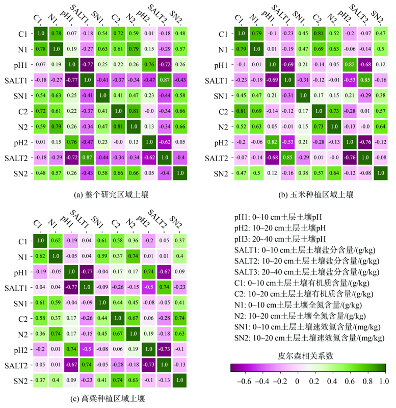
Analysis of the spatial heterogeneity of soil attributes and diagnosis of the soil stress for crops cultivated at large-scale saline-alkali farmland based on remote sensing spectral indices are important to improve the land utilization efficiency and contribute to improve economic and ecological benefits. In this study, we conducted an Unmanned Aerial Vehicle (UAV) remote sensing observation and field measurement over a typical coastal saline-alkali farmland (400 hm2) in the Yellow River Delta of Dongying City, Shandong province in China during the growing season of maize and sorghum in 2019. An eBee wing-fixed UAV platform (SenseFly, Cheseaux-Lausanne, Switzerland) equipped with a multiSPEC-4C multispectral camera (SenseFly, Cheseaux-Lausanne, Switzerland) was used to capture the spectral information of crops. Nine Vegetation Indices (VIs) were selected to characterize the growth status of crops. Among the nine VIs, MCARI, TCARI/OSAVI, and NDREI were sensitive to Leaf Chlorophyll Content (LCC); OSVAI, GNDVI, and MSR were sensitive to Above-Ground Biomass (AGB); and NDVI, EVI2, and MSRRE were sensitive to Leaf Area Index (LAI). Soil sampling (n = 195) at three layers (0~10 cm, 10~20 cm, and 20~40 cm) were implemented evenly across the study area. In total, five soil attributes were measured, including soil salinity (SALT, g/kg), pH, organic matter content (C, g/kg), total nitrogen content (N, g/kg), and available nitrogen content (SN, mg/kg). In our study, we first conducted an interpolation method using Inverse Distance Weighted (IDW) to map the spatial heterogeneity of soil attributes. Our interpolation results show that all the soil attributes showed obvious horizontal spatial heterogeneity, while pH and SALT showed remarkable vertical spatial heterogeneity. Second, we conducted the Pearson Correlation Analysis (PCA) between different soil attributes at each soil layer. The results of PCA showed that SALT and pH had a significantly negative correlation, and these two attributes were not related to SN, N, and C. While SN, N, and C had significantly positive relationships with each other. Finally, the influences of soil attributes on the growth status of maize and sorghum were assessed separately using the Recursive Feature Elimination (RFE) method along with the random forest model based on 3-fold cross validation and 100 times iteration. According to the importance values of soil attributes to VIs, the influence of soil attributes on crop growth from high to low was that SN>N, C>pH>SALT for maize, and SALT>pH>SN, N, C for sorghum. However, the dominant soil attributes that influenced crop growth were SN2 (i.e., SN at 10~20 cm soil layer) and SALT at 0~40 cm soil layer for maize and sorghum, respectively. This study proposes a 'soil-crop growth-VIs' framework for monitoring crop growth status based combining field sampling and UAV remote sensing observations, which is essential for agronomic management in saline-alkali land and contributes to the development of precision agriculture.

Key words: UAV remote sensing; multispectral; vegetation index; soil; crop; saline-alkaline land; precision agriculture; maize; sorghum
表1 研究选用的光谱指数及计算方法Tab. 1 Vegetation indices used in this study |
| 作物参数 | 光谱指数及公式 | 公式编号 | 参考文献 |
|---|---|---|---|
| LCC | (1) | [24] | |
| (2) | [25] | ||
| (3) | [26] | ||
| AGB | (4) | [22] | |
| (5) | |||
| (6) | |||
| LAI | (7) | [23] | |
| (8) | |||
| (9) |
注:R为红波段反射率;G为绿波段反射率;E为红边波段反射率;NIR为近红外波段反射率;x为调整系数,通常取值为0.16。 |
| [1] |
马玉蕾, 王德, 刘俊民, 等. 黄河三角洲典型植被与地下水埋深和土壤盐分的关系[J]. 应用生态学报, 2013,24(9):2423-2430.
[
|
| [2] |
|
| [3] |
|
| [4] |
|
| [5] |
|
| [6] |
|
| [7] |
|
| [8] |
|
| [9] |
|
| [10] |
|
| [11] |
|
| [12] |
|
| [13] |
|
| [14] |
|
| [15] |
|
| [16] |
|
| [17] |
|
| [18] |
|
| [19] |
|
| [20] |
|
| [21] |
鲍士旦等. 土壤农化分析[M]. 北京: 中国农业出版社, 2000.
[
|
| [22] |
|
| [23] |
|
| [24] |
|
| [25] |
|
| [26] |
|
| [27] |
郭勃. 基于RS和GIS的黄河三角洲盐碱地分级与治理研究[D]. 济南:山东师范大学, 2015.
[
|
| [28] |
|
| [29] |
余笑眉, 吕晓男, 王美琴, 等. 南方丘陵耕地土壤有机质空间插值精度比较——以衢江区为例[J]. 浙江农业学报, 2010,22(5):639-643.
[
|
| [30] |
周四维. 土壤属性三维建模方法及不确定性分析[D]. 武汉:华中农业大学, 2018.
[
|
| [31] |
|
| [32] |
|
| [33] |
赵英时等. 遥感应用分析原理与方法[M]. 北京: 科学出版社, 2003.
[
|
| [34] |
|
| [35] |
|
/
| 〈 |
|
〉 |