
基于坡位-地块单元的流域最佳管理措施空间优化配置方法
|
史亚星(1993— ),女,山西阳泉人,硕士生,主要从事流域系统综合模拟与情景分析研究。E-mail: shiyx@lreis.ac.cn |
收稿日期: 2020-06-29
要求修回日期: 2020-08-04
网络出版日期: 2021-06-25
基金资助
国家自然科学基金面上项目(41871362)
中国科学院A类战略性先导科技专项课题(XDA23100503)
版权
Spatial Optimization of Watershed Best Management Practices based on Slope Position-Field Units
Received date: 2020-06-29
Request revised date: 2020-08-04
Online published: 2021-06-25
Supported by
National Natural Science Foundation of China(41871362)
Chinese Academy of Sciences(XDA23100503)
Copyright
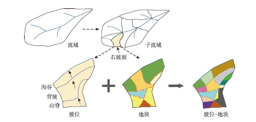
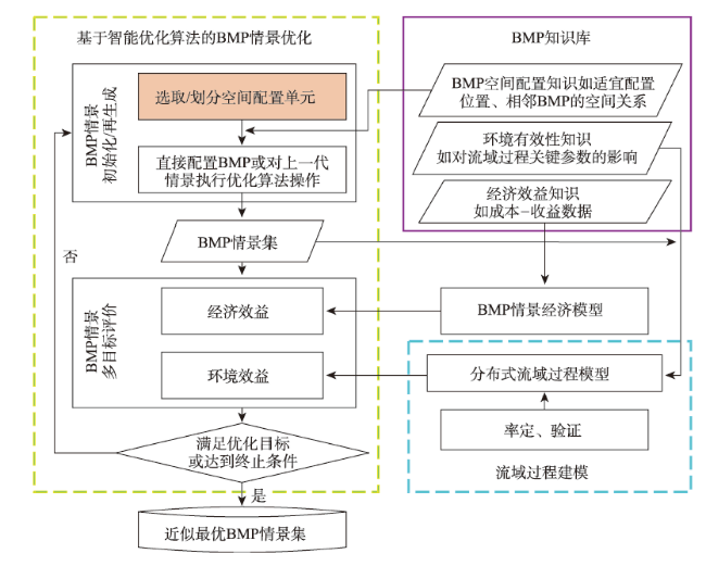
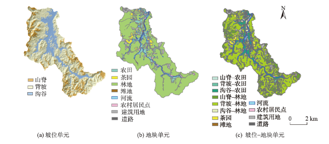
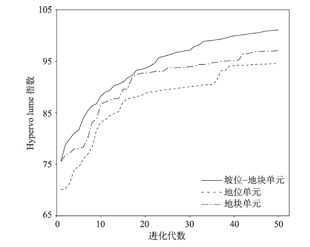
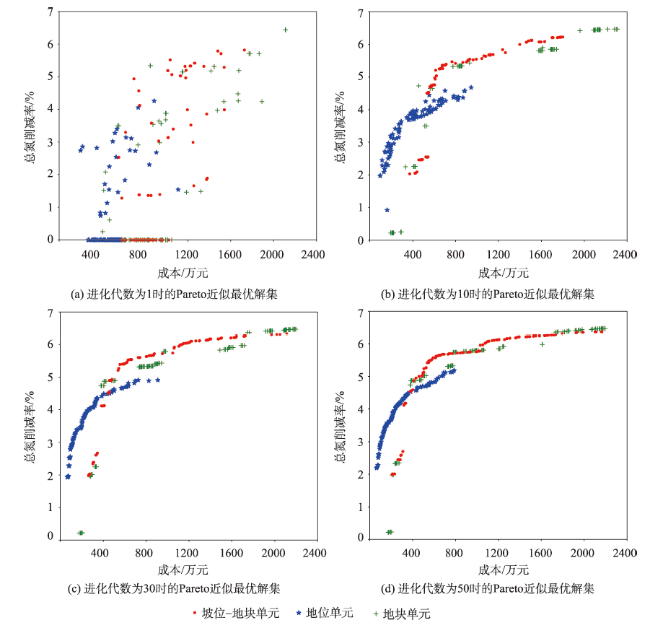
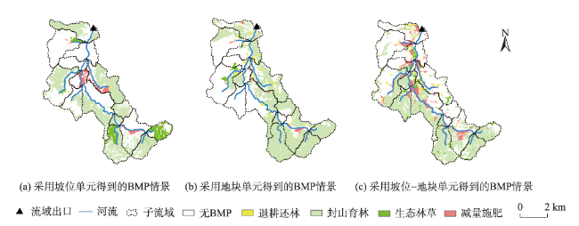
最佳管理措施(BMP)是治理流域土壤侵蚀、非点源污染等环境问题的有效途径,基于流域过程模拟的情景优化方法可得到综合效益近似最优的BMP空间配置方案集。目前用于配置BMP的空间单元(如子流域、水文响应单元、地块、坡位)均不能有效地综合体现BMP与地形部位间的空间关系以及同一地形部位内不同土地利用斑块上的BMP差异。本文提出将坡位单元与地块单元叠加生成的坡位-地块单元作为BMP空间配置单元,结合分布式流域建模框架SEIMS和多目标优化算法NSGA-II建立一套流域BMP空间优化配置方法。以江苏省溧阳市中田舍流域的非点源污染治理为例,选取减量施肥、退耕还林、封山育林和生态林草4种典型BMP,以最大化总氮削减率、最小化经济成本为优化目标,分别采用坡位单元、地块单元、坡位-地块单元进行情景优化。结果表明:相比坡位单元和地块单元,采用坡位-地块单元可获得最多具有近似最优综合效益的BMP情景,定量评价解集分布性和收敛性的Hypervolume指数分别提升了7%和4%,且BMP在空间上分布更加精细、配置更加灵活。本文方法可有效、合理地优化流域最佳管理措施的空间配置,为流域治理提供决策支持。
史亚星 , 朱良君 , 秦承志 , 朱阿兴 . 基于坡位-地块单元的流域最佳管理措施空间优化配置方法[J]. 地球信息科学学报, 2021 , 23(4) : 564 -575 . DOI: 10.12082/dqxxkx.2021.200335
Best Management Practices (BMPs) are effective ways to control environmental problems in watersheds such as soil erosion and nonpoint source pollution. BMP scenario optimization method based on watershed modeling and intelligent optimization algorithms can obtain near-optimal Pareto solutions with comprehensive cost-effectiveness. Existing spatial units used for BMP configuration in optimizing BMP scenarios (e.g., subbasins, Hydrological Response Units (HRUs), farms, and slope position units) cannot comprehensively represent spatial relationships between BMPs and topographical positions and differences of BMPs configured on various landuse units within the same topographical position. In other words, these spatial units cannot effectively consider both the characteristics of natural processes and the flexibility of BMP configuration during BMP scenario optimization in a watershed. In this paper, a composite type of spatial unit, the so-called "slope position-field" unit, is proposed to be the BMP configuration unit, which can incorporate the advantage of slope positions (i.e., effectively considering spatial allocation relationship between BMP and topographic position at the hillslope scale) and that of landuse fields (i.e., effectively considering the difference of BMP configurations on various landuse units within a topographical location). Based on a distributed watershed modeling framework named SEIMS (Spatially Explicit Integrated Modeling System) and a multi-objective optimization algorithm named NAGA-II ( Non-dominated Sorting Genetic Algorithm II), a methodological spatial optimization framework of BMP configuration based on the slope position-field units is designed. The method was examined by a case study of controlling nonpoint source pollution in the Zhongtianshe watershed, Liyang city, Jiangsu province, China. Four types of BMPs (e.g., reducing fertilizer application, returning farmland to forest, closed forest, and planting ecologic forest and grass) were selected. The optimization objectives are maximizing the reduction rate of total nitrogen output at the watershed outlet and minimizing the economic cost of the BMP scenario. The proposed BMP configuration unit was compared with two existing types of BMP configuration units such as slope position unit and field unit on the effectiveness of watershed BMP scenario optimization. The results present that: (1) compared with slope position units and field units, taking slope position-field units as BMP configuration units can obtain the largest number of optimized BMP scenarios that have the best comprehensive cost-effectiveness, which can be interpreted from the scatter plot of Pareto solutions, and proved by the quantitative Hypervolume index (with an increase of 7% and 4%, respectively); (2) BMP scenarios based on slope position-field units have more fragmented but finer spatial distribution of BMPs. Therefore, slope position-field units are more flexible for BMP configuration and hence maybe more beneficial for actual BMP implementation. In conclusion, the proposed method can optimize the spatial configuration of BMPs effectively and reasonably, so as to support decision making for watershed management.
表1 研究区选用的4种BMP简介及其适宜配置的坡位类型和土地利用类型Tab. 1 Brief descriptions of the four selected BMPs associated with their suitable slope positions and landuse types |
| BMP | 简介 | 适宜坡位 | 适宜土地利用类型 |
|---|---|---|---|
| 减量施肥 | 在保证作物产量的前提下合理减少施肥量,降低造成污染的可能性 | 背坡、沟谷 | 农田 |
| 退耕还林 | 从保护和改善生态环境目的出发,在易造成水土流失的耕地上,逐步停止耕种,因地制宜植树造林 | 背坡、沟谷 | 农田 |
| 封山育林 | 山区定期封山,禁止砍柴、垦荒、放牧等人为活动,利用自然的更新能力,恢复森林植被 | 山脊、背坡 | 林地 |
| 生态林草 | 通过种植草、乔木、灌木等方式降低土壤侵蚀,减少养分随土壤迁移 | 山脊、背坡、沟谷 | 林地 |
表2 研究区日尺度模型在流域出口流量、泥沙和总氮的率定结果及月尺度水文模型的率定标准Tab. 2 The calibration results at a daily timestep of streamflow, sediment and total nitrogen at the watershed outlet of the Youwuzhen watershed model, compared to the satisfactory standards of hydrological modeling at a monthly timestep |
| 率定变量 | 率定结果(2014-01-01—2014-12-31) | 月尺度模拟的可接受范围[35] | |||||
|---|---|---|---|---|---|---|---|
| NSE | RSR | PBIAS /% | NSE | RSR | |PBIAS| /% | ||
| 流量/m3s-1 | 0.65 | 0.59 | -2.62 | >0.50 | ≤0.70 | <25 | |
| 泥沙/kg | 0.43 | 0.75 | 22.83 | >0.50 | ≤0.70 | <55 | |
| 总氮/kg | 0.59 | 0.64 | 33.70 | >0.50 | ≤0.70 | <70 | |
感谢南京师范大学李硕教授水文研究组提供的研究区水文、水质数据。
| [1] |
陈洪波, 王业耀. 国外最佳管理措施在农业非点源污染防治中的应用[J]. 环境污染与防治, 2006,28(4):279-282.
[
|
| [2] |
张玉珍, 陈能汪, 曹文志, 等. 南方丘陵地区农业小流域最佳管理措施模拟评价[J]. 资源科学, 2005,27(6):151-155.
[
|
| [3] |
朱阿兴, 朱良君, 史亚星, 等. 流域系统综合模拟与情景分析——自然地理综合研究的新范式?[J]. 地理科学进展, 2019,38(8):1111-1122.
[
|
| [4] |
耿润哲, 梁璇静, 殷培红, 等. 面源污染最佳管理措施多目标协同优化配置研究进展[J]. 生态学报, 2019,39(8):2667-2675.
[
|
| [5] |
|
| [6] |
吴辉, 刘永波, 朱阿兴, 等. 流域最佳管理措施空间配置优化研究进展[J]. 地理科学进展, 2013,32(4):570-579.
[
|
| [7] |
高会然, 秦承志, 朱良君, 等. 以坡位为空间配置单元的流域管理措施情景优化方法[J]. 地球信息科学学报, 2018,20(6):781-790.
[
|
| [8] |
|
| [9] |
|
| [10] |
|
| [11] |
|
| [12] |
|
| [13] |
|
| [14] |
|
| [15] |
|
| [16] |
|
| [17] |
|
| [18] |
|
| [19] |
|
| [20] |
|
| [21] |
|
| [22] |
|
| [23] |
蔡强国, 朱阿兴, 毕华兴. 中国主要水蚀区水土流失综合调控与治理范式[M]. 北京: 中国水利水电出版社, 2012.
[
|
| [24] |
|
| [25] |
|
| [26] |
|
| [27] |
|
| [28] |
|
| [29] |
|
| [30] |
|
| [31] |
|
| [32] |
|
| [33] |
|
| [34] |
|
| [35] |
|
| [36] |
|
| [37] |
|
| [38] |
|
| [39] |
|
| [40] |
|
| [41] |
|
| [42] |
李兆富, 刘红玉, 李恒鹏. 天目湖流域湿地对氮磷输出影响研究[J]. 环境科学, 2012,33(11):3753-3759.
[
|
| [43] |
席庆, 李兆富, 罗川. 基于扰动分析方法的AnnAGNPS模型水文水质参数敏感性分析[J]. 环境科学, 2014,35(5):1773-1780.
[
|
| [44] |
吴俊, 樊剑波, 何园球, 等. 苕溪流域不同施肥条件下稻田田面水氮磷动态特征及产量研究[J]. 土壤, 2013,45(2):207-213.
[
|
| [45] |
王媛, 楚春礼, 刘夏, 等. 率水流域非点源污染分析及施肥措施模拟[J]. 水资源与水工程学报, 2019,30(4):6-13.
[
|
| [46] |
|
| [47] |
|
| [48] |
|
| [49] |
|
/
| 〈 |
|
〉 |

