
基于沙地指数模型的沙地监测方法
|
李宇君(1996— ),女,山西太原人,硕士生,主要从事沙化土地分类研究。E-mail: liyj@radi.ac.cn |
收稿日期: 2020-04-03
要求修回日期: 2020-06-16
网络出版日期: 2021-06-25
基金资助
国家重点研发计划项目(2016YFC0500806)
版权
Sandy Land Monitoring Method based on Classification Index Model
Received date: 2020-04-03
Request revised date: 2020-06-16
Online published: 2021-06-25
Supported by
National Key Research and Development Programof China(2016YFC0500806)
Copyright
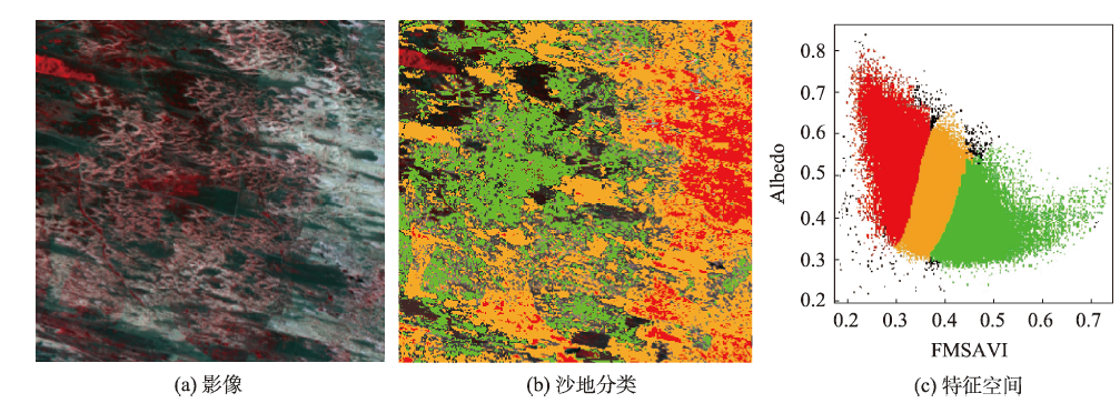
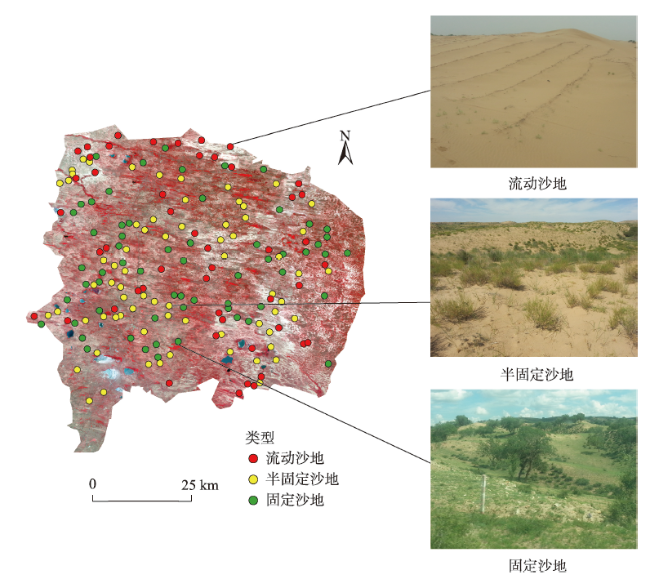
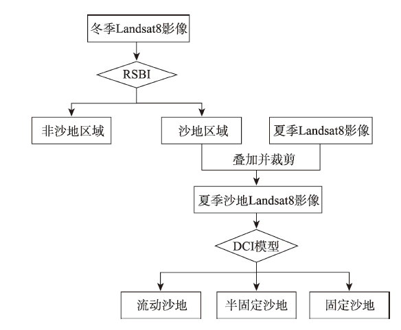
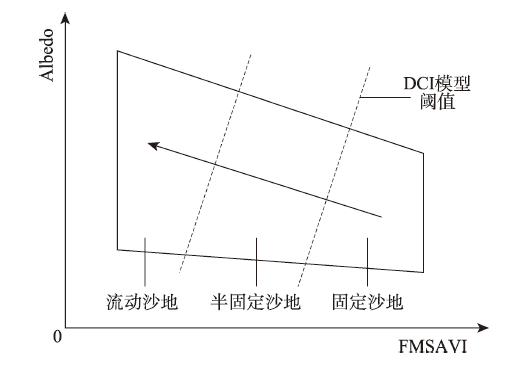
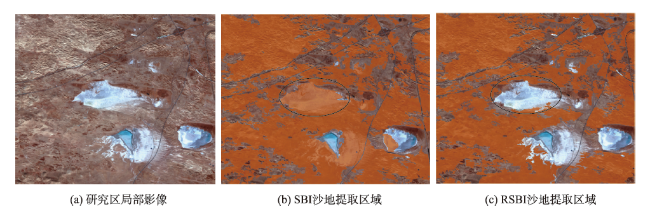
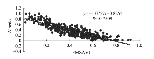
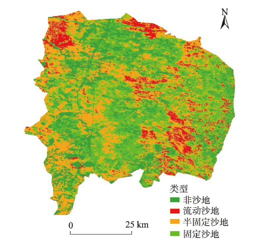
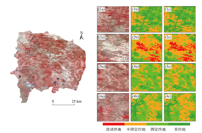
沙漠化是干旱、半干旱地区的重要生态环境问题,我国西北地区沙漠化土地分布广泛,加剧的沙漠化问题影响着区域经济和社会的发展,遥感技术的进步为沙漠化评估与制图提供了重要手段。本文以内蒙古自治区浑善达克沙地为研究区,基于面向对象方法,对研究区Landsat8 OLI影像进行沙地最优尺度分割。以分割对象为基础,实验在冬夏季影像上分层分阶段提取沙地。在冬季影像上,本文提出新比值型指数RSBI(Ratio Soil Brightness Index)对沙地进行提取,精度较SBI指数提高4.11%。后基于改进型植被覆盖度指数(FMSAVI)与反照率(Albedo)构建二维特征空间,建立沙地分类指数模型(DCI),对夏季影像沙区分类。该方法总体精度为83.24%,较NDVI-Albedo二维特征空间模型精度提高5.59%,较FMSAVI模型提高16.20%。本文结合RSBI指数与FMSAVI-Albedo特征空间反演的DCI指数模型来提取沙地信息并对沙地分类,减少了沙地提取误差,提高了分类精度,为沙地信息的研究提供了新思路。
李宇君 , 张磊 . 基于沙地指数模型的沙地监测方法[J]. 地球信息科学学报, 2021 , 23(4) : 680 -691 . DOI: 10.12082/dqxxkx.2021.200161
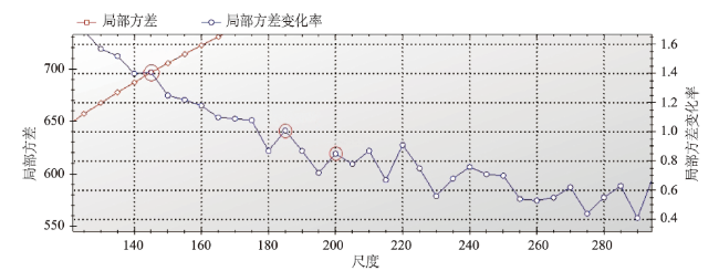
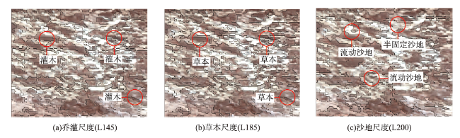
Desertification has become one of the most serious environmental problems facing the world today, which is also one of serious environmental threats in southwest China. Remote sensing technology offers substantial information for assessment of desertification. Based on remote sensing technology, our study aimed to extract the sandy land information and map the land cover classification in Otindag sandy land. We proposed a new sandy land extraction index and a new sandy land classification model to extract and classify sandy land at different times and levels on the basis of object-oriented classification. First, we segmented the image of study area using optimal segmentation scales evaluated by ESP2 in eCognition. The results show that the optimal segmentation scales for sandy land, shrub, and herb were 200, 145, and 185, respectively. Then in order to extract sandy land, we proposed the Ratio Soil Brightness Index (RSBI). Compared with SBI, RSBI can avoid the misclassification between water body and non-sandy land and hence had higher precision. In order to avoid the misclassification between the fixed sandy land and areas with relatively high vegetation coverage, we extracted sandy land at different times and levels. We first used RSBI to extract sandy land in the winter image. The index of MSAVI was introduced to derive the coverage of vegetation, named as FMSAVI. FMSAVI and Albedo were selected to construct two-dimensional feature space in sandy land area extracted by RSBI in the summer image. After normalization of FMSAVI and Albedo, a liner regression analysis was performed. Based on this, a Desertification Classification Index (DCI) was developed. The DCI was a collection of lines perpendicular to the fit line. Different positions of the lines mean different sandy land classifications. A map of sandy land classification was generated and we grouped sandy land into three classes, namely shifting sandy land, semi-fixed sandy land, and fixed sandy land. Our result show that the overall accuracy of DCI model was 83.24%, higher than traditional methods using modified vegetation coverage (67.04%) and NDVI-Albedo feature space (77.65%) to classify sandy land. We proposed the RSBI to extract sandy land in the winter image and constructed FMSAVI-Albedo feature space to classify sandy land in summer image. These two indexes improved classification accuracy. Our methods are simple, robust, powerful, and easy to use for the extraction and classification of sandy land.
Key words: object-oriented; sandy land; sandy land index; feature space; classification model; NDVI; MSAVI; Albedo
表1 Landsat8 OLI波段信息Tab. 1 Band information of Landsat8 OLI |
| 波段 | 波长范围/μm | 空间分辨率/m |
|---|---|---|
| 海岸波段 | 0.433~0.453 | 30 |
| 蓝波段 | 0.450~0.515 | 30 |
| 绿波段 | 0.525~0.600 | 30 |
| 红波段 | 0.630~0.680 | 30 |
| 近红外波段 | 0.845~0.885 | 30 |
| 短波红外1 | 1.560~1.660 | 30 |
| 短波红外2 | 2.100~2.300 | 30 |
| 全色波段 | 0.500~0.680 | 15 |
| 卷云波段 | 1.360~1.390 | 30 |
| 热红外1 | 10.60~11.19 | 100 |
| 热红外2 | 11.50~12.51 | 100 |
表2 沙地与非沙地混淆矩阵与分类精度Tab. 2 Confusion matrix and classification accuracy of of sandy land and non-sandy land |
| 指标 | 类别 | 沙地 | 非沙地 | 用户精度/% |
|---|---|---|---|---|
| RSBI | 沙地 | 71 | 6 | 92.40 |
| 非沙地 | 12 | 76 | 86.81 | |
| 生产者精度/% | 85.88 | 92.94 | ||
| 总体精度/% | 89.41 | |||
| SBI | 沙地 | 72 | 16 | 82.60 |
| 非沙地 | 9 | 69 | 88.46 | |
| 生产者精度/% | 89.41 | 81.18 | ||
| 总体精度/% | 85.30 | |||
表3 各类沙化土地类型混淆矩阵与分类精度Tab. 3 Confusion matrix and classification accuracy of different types of sandy land |
| 流动沙地 | 半固定沙地 | 固定沙地 | 用户精度/% | |
|---|---|---|---|---|
| 流动沙地 | 48 | 9 | 0 | 84.21 |
| 半固定沙地 | 7 | 49 | 5 | 80.32 |
| 固定沙地 | 0 | 8 | 52 | 86.67 |
| 非沙地 | 0 | 0 | 1 | |
| 生产者精度/% | 87.27 | 74.24 | 89.66 | |
| 总体精度/% | 83.24 | |||
| [1] |
冯益明, 郑冬梅, 智长贵, 等. 面向对象的沙化土地信息提取[J]. 林业科学, 2013,49(1):126-133.
[
|
| [2] |
李金桐, 镨拉提, 纪良, 等. 基于GIS的MODIS环境荒漠化监测中的应用方法研究[J]. 沙漠与绿洲气象, 2003,26(2):21-23.
[
|
| [3] |
李宝林, 周成虎. 东北平原西部沙地近10年的沙质荒漠化[J]. 地理学报, 2001,68(3):307-315.
[
|
| [4] |
宋伟东, 张亚男, 高琳, 等. 面向对象与决策树模型的辽西北地区沙化信息提取[J]. 辽宁工程技术大学学报(自然科学版), 2018,37(3):149-155.
[
|
| [5] |
|
| [6] |
|
| [7] |
冯娟, 丁建丽, 魏雯瑜. 基于Albedo-MSAVI特征空间的渭库绿洲土壤盐渍化研究[J]. 中国农村水利水电, 2018(2):147-152.
[
|
| [8] |
|
| [9] |
王志波, 高志海, 王琫瑜, 等. 基于面向对象方法的沙化土地遥感信息提取技术研究[J]. 遥感技术与应用, 2012(5):770-777.
[
|
| [10] |
美国地质调查局[EB/OL].(https://earthexplorer.usgs.gov/).
[ United states geological survey[EB/OL]. (https://earthexplorer.usgs.gov/). ]
|
| [11] |
|
| [12] |
钟春棋, 曾从盛, 柳铮铮. 基于谱间特征与比值型指数的水体影像识别分析[J]. 地球信息科学, 2008,10(5):663-669.
[
|
| [13] |
|
| [14] |
中华人民共和国国家质量监督检验检疫总局, 中国国家标准化管理委员会. GB/T24255-2009: 沙化土地监测技术规程[S]. 北京: 中国标准出版社, 2009.
[ General Administration of Quality Supervision, Inspection and Quarantine of the People's Republic of China, Standardization Administration. GB/T24255-2009, Technical code of practice on the sandified land monitoring[S]. Beijing:Standards Press of China, 2009. ]
|
| [15] |
曾永年, 向南平, 冯兆东, 等. Albedo-NDVI特征空间及沙漠化遥感监测指数研究[J]. 地理科学, 2006,26(1):75-81.
[
|
| [16] |
|
| [17] |
|
| [18] |
|
| [19] |
|
| [20] |
刘英, 李遥, 鲁杨, 等. 2000—2016年黄土高原地区荒漠化遥感分析[J]. 遥感信息, 2019,34(2):30-35.
[
|
| [21] |
岳辉, 刘英. 基于NDVI-Albedo特征空间的陕西省干旱与荒漠化遥感监测[J]. 西北林学院学报, 2019,34(1):204-211.
[
|
| [22] |
|
| [23] |
|
| [24] |
|
| [25] |
|
/
| 〈 |
|
〉 |


