
基于改进Markov-CA模型的黄土高原土地利用多情景模拟
|
孙定钊(1996— ),男,贵州遵义人,硕士生,主要从事生态系统服务评估研究。E-mail:dingzhao_sun@163.com |
收稿日期: 2020-06-04
要求修回日期: 2020-07-22
网络出版日期: 2021-07-25
基金资助
国家自然科学基金项目(41601184)
黄土高原土壤侵蚀与旱地农业国家重点实验室开放基金(A314021402-202110)
版权
Multi-scenario Simulation of Land Use Dynamic in the Loess Plateau using an Improved Markov-CA Model
Received date: 2020-06-04
Request revised date: 2020-07-22
Online published: 2021-07-25
Supported by
National Natural Science Foundation of China(41601184)
Open Fund of State Key Laboratory of Soil Erosion and Dryland Farming on the Loess Plateau(A314021402-202110)
Copyright
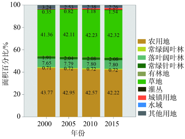
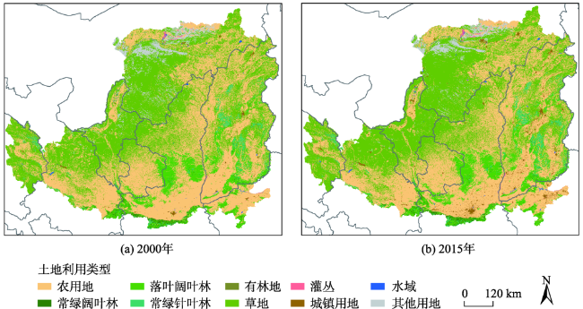
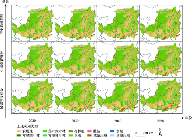
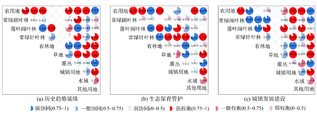
土地利用/覆被的时空变化研究能为区域生态环境恢复和生态系统集成管理提供科学支持。集成Logistic回归模型、改进的Markov与FLUS模型模拟黄土高原2020—2050年3种典型情景土地利用变化。发现各情景土地利用面积变化及空间置换转移主要集中在农用地、草地和城镇用地;历史趋势延续情景下农用地减少15 205 km2,草地、城镇用地分别增加2742 km2和16 007 km2;生态保育管护情景中草地增加7076 km2,林草用地增长存在权衡关系(r主要林地-草地=-0.66),在典型区域的生态恢复管理中应加以重视;城镇发展建设情景中农用地减少20 256 km2,城镇用地增加22 032 km2,变化均达到极值,其中,南部城镇扩张与农用地减少存在强权衡关系(r农用地-城镇用地=-1)。改进的Markov-FLUS模型适用于黄土高原地区的土地利用模拟,情景分析可有效揭示区域生态保护与城镇扩张的阈值变化,为区域土地利用政策权衡管理和水土保育提供科学依据。

孙定钊 , 梁友嘉 . 基于改进Markov-CA模型的黄土高原土地利用多情景模拟[J]. 地球信息科学学报, 2021 , 23(5) : 825 -836 . DOI: 10.12082/dqxxkx.2021.200283
Simulating the spatiotemporal land use and land cover dynamic can provide a scientific support for regional ecological environment restoration and integrated ecosystem management. In this study, an improved Logistic-Markov-FLUS model was used to simulate land-use changes (2020—2050) under multi-scenarios in the Loess Plateau. Results show that the changes of land use area and spatial displacement were mainly concentrated in agricultural land, grassland, and urban land. In the historical trend scenario, a decreasing trend was observed in cropland with a decreased area of 15 205 km2, while an increasing trend was found in the grassland and urban land with an increased area of 2742 km2 and 16 007 km2, respectively. In the ecological conservation management scenario, the policy for vegetation protection had a significant effect on the increase of grassland (7076 km2), showing a significant trade-off ($r_{main forestland-grassland}=-0.66$) between grassland and forest growth due to the coexistence of land transformation. Ecological protection and construction should fully consider this ecological trade-off in specific regions. The reduction of cropland (20,256 km2) and urban land (22 032 km2) in the urban development and construction scenario was the largest. There was a strong trade-off ($r_{agricultural-urban}=-1$) between the expansion of urban land and the reduction of cropland in the southern regions. The improved Markov-FLUS model had better performance on multi-scale land use dynamic simulation in the Loess Plateau. The scenario-based method can also be used to explore the abrupt changes in ecological protection and urban expansion for better LUCC decision-making and trade-off management of ecosystems.
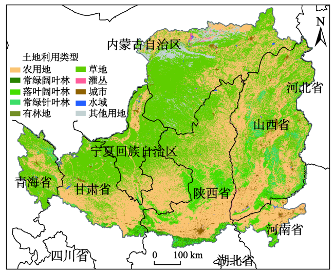
表1 ESA CCI土地利用数据的重分类Tab. 1 Reclassification of land-use types for the ESA CCI dataset |
| 重分类编号 | 重分类名称 | 原始地类编号 | 原始地类描述及编号 |
|---|---|---|---|
| 1 | 农用地 | 10 | 农田、雨养 |
| 20 | 农田、灌溉或注水后 | ||
| 30 | 镶嵌农田(>50%)/自然植被(树木、灌丛、草本覆盖) (<50%) | ||
| 40 | 镶嵌自然植被(树木,灌丛,草本覆盖) (>50%)/农田(<50%) | ||
| 2 | 常绿阔叶林 | 50 | 树木覆盖、阔叶、常绿、郁闭度(>15%) |
| 3 | 落叶阔叶林 | 60 | 树木覆盖、阔叶、落叶、郁闭度 (>15%) |
| 4 | 常绿针叶林 | 70 | 树木覆盖、针叶、常绿、郁闭度(>15%) |
| 5 | 有林地 | 80 | 树木覆盖、针叶、落叶、郁闭度(>15%) |
| 100 | 镶嵌树木和灌丛(>50%)/草本覆盖(<50%) | ||
| 160 | 树木覆盖、淹没、淡水或半咸水 | ||
| 170 | 树木覆盖、淹没、咸水 | ||
| 6 | 草地 | 110 | 镶嵌草本覆盖(>50%)/树木和灌丛(<50%) |
| 130 | 草地 | ||
| 7 | 灌丛 | 120 | 灌木地 |
| 180 | 灌木和草本覆盖、淹没、淡水/咸水/半咸水 | ||
| 8 | 城镇用地 | 190 | 城镇地区 |
| 9 | 水域 | 210 | 水体 |
| 220 | 永久冰雪 | ||
| 10 | 其他用地 | 140 | 地衣和苔藓 |
| 150 | 稀疏植被(树木、灌丛、草本覆盖) (<15%) | ||
| 200 | 裸地 |
表2 不同情景的取值Tab. 2 Valuesof in different scenarios |
| 情景 | 描述 | 情景权重矩阵取值 |
|---|---|---|
| 历史趋势延续 | 继承历史时期各地类变化趋势 | — |
| 生态保育管护 | 农用地与城镇用地的扩张减缓,林草地快速增长 | Diag (0.95, 1.2, 1.2, 1.2, 1.2, 1.2, 1.1, 0.85, 1, 1) |
| 城镇发展建设 | 城镇用地的快速扩张,压缩林草地增长 | Diag (1.1, 0.9, 0.9, 0.9, 0.9, 0.9, 1, 1.2, 1,1) |
图5 黄土高原2020―2050年多情景土地利用需求预测Fig. 5 Predictionof Land use demand under different scenarios in the Loess Plateau during 2020-2050 |
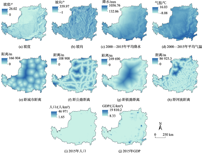
表3 驱动因子Logistic回归分析Tab. 3 Logistic regression analysisof driving factors |
| 驱动因子 | 农用地 | 常绿阔 叶林 | 落叶阔 叶林 | 常绿针 叶林 | 有林地 | 草地 | 灌丛 | 城镇用地 | 水域 | 其他用地 |
|---|---|---|---|---|---|---|---|---|---|---|
| 坡度 | -0.164 | 0.186 | 0.034 | 0.118 | 0.132 | 0.090 | -0.362 | -0.424 | -0.324 | -0.054 |
| 坡向 | -0.001 | ― | ― | 0.001 | ― | 0.001 | ― | ― | ― | 0.001 |
| 降水 | 0.000 | 0.001 | 0.002 | 0.001 | 0.001 | -0.001 | 0.000 | ― | 0.000 | -0.001 |
| 气温 | 0.011 | 0.006 | 0.002 | -0.017 | -0.100 | -0.023 | 0.026 | 0.014 | ― | -0.035 |
| 距城市距离 | 0.000 | 0.000 | 0.000 | 0.000 | ― | 0.000 | 0.000 | 0.000 | 0.000 | 0.000 |
| 距公路距离 | 0.000 | 0.000 | 0.000 | 0.000 | 0.000 | 0.000 | 0.000 | 0.000 | ― | 0.000 |
| 距铁路距离 | ― | 0.000 | 0.000 | 0.000 | 0.000 | 0.000 | 0.000 | 0.000 | 0.000 | 0.000 |
| 距河流距离 | 0.000 | ― | 0.000 | 0.000 | ― | 0.000 | ― | 0.000 | 0.000 | 0.000 |
| GDP | 0.000 | ― | ― | ― | ― | ― | ― | 0.000 | 0.000 | 0.001 |
| 人口 | 0.000 | ― | 0.000 | ― | ― | ― | ― | 0.000 | ― | -0.015 |
| 常数 | -0.871 | -13.944 | -13.555 | -7.422 | -8.239 | 3.586 | -7.520 | -2.711 | -3.628 | 3.806 |
| ROC值 | 0.738 | 0.962 | 0.916 | 0.901 | 0.882 | 0.811 | 0.830 | 0.889 | 0.744 | 0.941 |
注:“―”指P≤0.05时未通过检验被剔除。 |
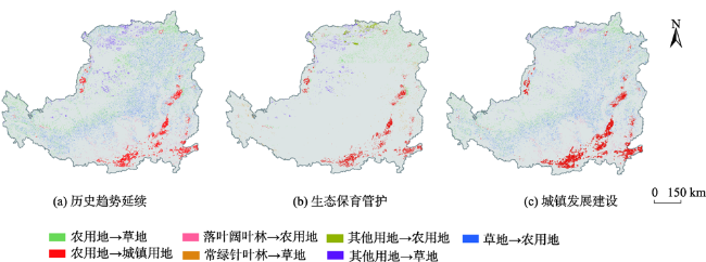
图8 黄土高原地区2015—2050年不同情景下的土地利用转移Fig. 8 Land-use transferring under different scenarios in the Loess Plateau from 2015 to 2050 |
| [1] |
李秀彬. 全球环境变化研究的核心领域——土地利用/土地覆被变化的国际研究动向[J]. 地理学报, 1996,51(6):553-558.
[
|
| [2] |
刘纪远, 张增祥, 庄大方, 等. 20世纪90年代中国土地利用变化时空特征及其成因分析[J]. 地理研究, 2003,22(1):1-12.
[
|
| [3] |
刘纪远, 张增祥, 徐新良, 等. 21世纪初中国土地利用变化的空间格局与驱动力分析[J]. 地理学报, 2009,64(12):1411-1420.
[
|
| [4] |
于兴修, 杨桂山. 中国土地利用/覆被变化研究的现状与问题[J]. 地理科学进展, 2002,21(1):51-57.
[
|
| [5] |
刘洋, 蒙吉军, 朱利凯. 区域生态安全格局研究进展[J]. 生态学报, 2010,30(24):6980-6989.
[
|
| [6] |
刘纪远, 张增祥, 张树文, 等. 中国土地利用变化遥感研究的回顾与展望——基于陈述彭学术思想的引领[J]. 地球信息科学学报, 2020,22(4):680-687.
[
|
| [7] |
王海军, 夏畅, 刘小平, 等. 大尺度和精细化城市扩展CA的理论与方法探讨[J]. 地理与地理信息科学, 2016,32(5):1-8.
[
|
| [8] |
|
| [9] |
|
| [10] |
|
| [11] |
周成虎, 欧阳, 马廷, 等. 地理系统模拟的CA模型理论探讨[J]. 地理科学进展, 2009,28(6):833-838.
[
|
| [12] |
|
| [13] |
|
| [14] |
赵小汎, 陈文波, 代力民. Markov和灰色模型在土地利用预测中的应用[J]. 水土保持研究, 2007,14(2):19-21.
[
|
| [15] |
|
| [16] |
|
| [17] |
王希营, 付梅臣, 刘宗强. 土地利用规划中建设用地需求量预测的两种模型比较——以东方市为例[J]. 资源与产业, 2009,11(5):87-91.
[
|
| [18] |
全泉, 田光进, 沙默泉. 基于多智能体与元胞自动机的上海城市扩展动态模拟[J]. 生态学报, 2011,31(10):2875-2887.
[
|
| [19] |
陆汝成, 黄贤金, 左天惠, 等. 基于CLUE—S和Markov复合模型的土地利用情景模拟研究——以江苏省环太湖地区为例[J]. 地理科学, 2009,29(4):577-581.
[
|
| [20] |
梁友嘉, 徐中民, 钟方雷. 基于SD和CLUE-S模型的张掖市甘州区土地利用情景分析[J]. 地理研究, 2011,30(3):564-576.
[
|
| [21] |
刘国彬, 上官周平, 姚文艺, 等. 黄土高原生态工程的生态成效[J]. 中国科学院院刊, 2017,32(1):11-19.
[
|
| [22] |
周书贵, 邵全琴, 曹巍. 近20年黄土高原土地利用/覆被变化特征分析[J]. 地球信息科学学报, 2016,18(2):190-199.
[
|
| [23] |
|
| [24] |
信忠保, 许炯心, 余新晓. 近50年黄土高原水土流失的时空变化[J]. 生态学报, 2009,29(3):1129-1139.
[
|
| [25] |
|
| [26] |
|
| [27] |
|
| [28] |
黄焕春, 运迎霞. 基于改进logistic-CA的城市形态多情景模拟预测分析——以天津滨海地区为例[J]. 地球信息科学学报, 2013,15(3):380-388.
[
|
| [29] |
|
| [30] |
|
| [31] |
|
| [32] |
国务院. 全国主体功能区规划[EB/OL]. http://www.gov.cn/zwgk/2011-06/08/content_1879180.htm.
[ State Council. National Major Function Zone Planning[EB/OL]. http://www.gov.cn/zwgk/2011-06/08/content_1879180.htm. ]
|
| [33] |
环境保护部.全国生态功能区划(修编版)[EB/OL]. .
[ Ministry of Ecology and Environment of the People’s Republic of China. National Ecological Function Zoning (Revised Edition)[EB/OL]. ]
|
| [34] |
国家发展改革委. 黄土高原地区综合治理规划大纲(2010-2030年)[EB/OL]. http://zfxxgk.ndrc.gov.cn/web/iteminfo.jsp?id=271.
[ National Development and Reform Commission. Outline of Comprehensive Management Plan for the Loess Plateau(2010-2030)[EB/OL]. http://zfxxgk.ndrc.gov.cn/web/iteminfo.jsp?id=271. ]
|
| [35] |
|
| [36] |
IPCC. Climate change 2013: The physical science basis. contribution of working group I to the fifth assessment report of the intergovernmental panel on climate change[R]. Cambridge and New York: Cambridge UniversityPress, 2013: 159-254.
|
| [37] |
孙艺杰, 任志远, 郝梦雅, 等. 黄土高原生态系统服务权衡与协同时空变化及影响因素——以延安市为例[J]. 生态学报, 2019,39(10):3443-3454.
[
|
| [38] |
|
/
| 〈 |
|
〉 |
