
顾及数据配准的江西省SRTM DEM精度评价和修正
|
杨 帅(1993— ),男,山东临沂人,硕士生,主要从事空间数据质量改善方面的研究。E-mail:shuai_yang0209@163.com |
收稿日期: 2020-07-25
要求修回日期: 2020-12-26
网络出版日期: 2021-07-25
基金资助
国家自然科学基金项目(41804001)
国家自然科学基金项目(41371367)
山东省自然科学基金项目(ZR2020YQ26)
山东省自然科学基金项目(ZR2019MD007)
山东省自然科学基金项目(ZR2019BD006)
山东省高等学校青创科技支持计划(2019KJH007)
版权
Accuracy Assessment and Improvement of SRTM DEM based on ICESat/GLAS under the Consideration of Data Coregistration over Jiangxi Province
Received date: 2020-07-25
Request revised date: 2020-12-26
Online published: 2021-07-25
Supported by
National Natural Science Foundation of China(41804001)
National Natural Science Foundation of China(41371367)
Shandong Provincial Natural Science Foundation, China(ZR2020YQ26)
Shandong Provincial Natural Science Foundation, China(ZR2019MD007)
Shandong Provincial Natural Science Foundation, China(ZR2019BD006)
A Project of Shandong Province Higher Educational Youth Innovation Science and Technology Program(2019KJH007)
Copyright
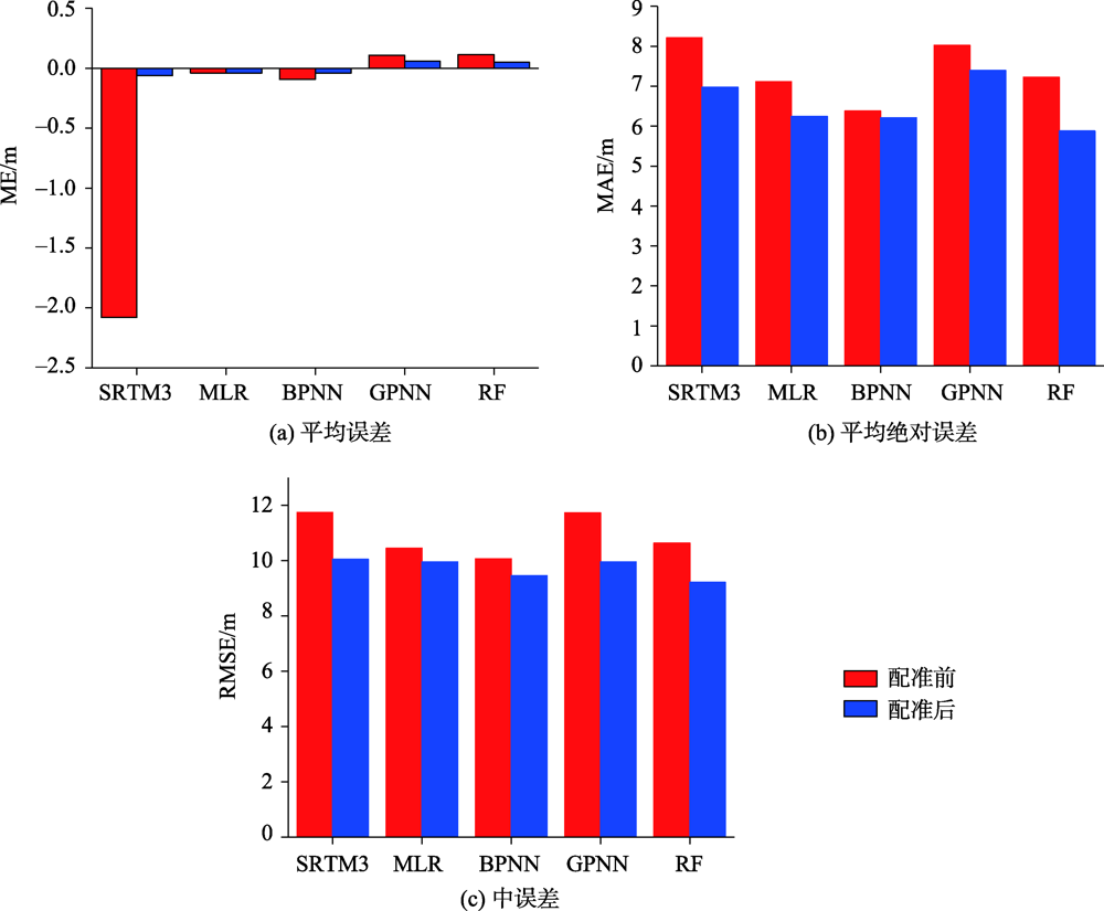
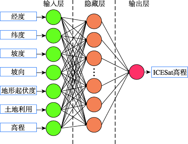
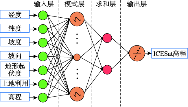
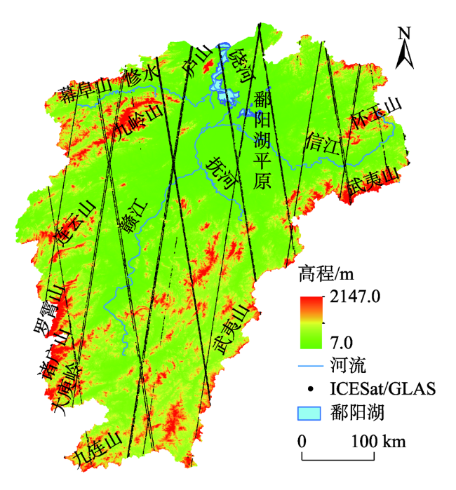
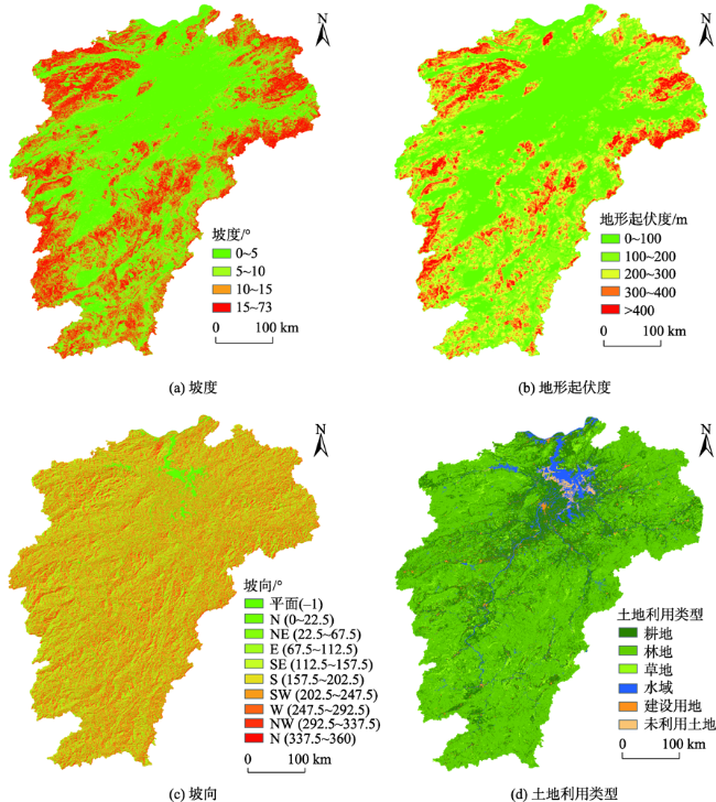
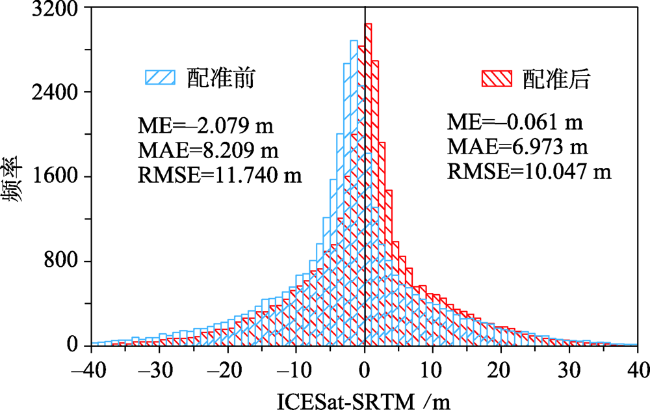
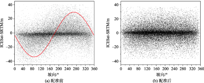
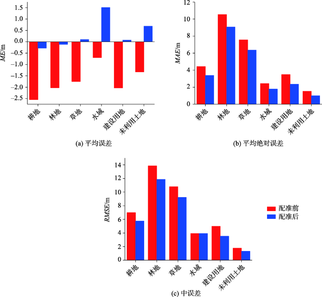
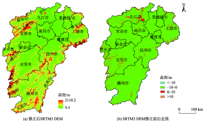
目前,ICESat/GLAS是大尺度SRTM DEM精度评价的主要数据源。然而,现有的精度评价方法均忽略了2组数据的有效配准。为此,本文分析了数据配准前、后SRTM DEM整体精度差异,以及不同地形因子和土地利用类型对SRTM DEM影响程度。在此基础上,充分考虑SRTM DEM精度影响因素,分别借助多元线性回归(MLR)、后向传播神经网络(BPNN)、广义回归神经网络(GRNN)以及随机森林(RF)对SRTM DEM修正。结果分析表明:配准前,ICESat/GLAS与SRTM DEM沿x、y方向的平均水平位移分别为-17.588 m、-29.343 m,高程方向系统偏差为-2.107 m;配准后,SRTM DEM的系统误差基本消除,而且中误差降低了14.4%。配准前,坡向与SRTM DEM误差呈正弦函数关系,配准后这种关系基本消失。SRTM DEM误差均随地形起伏度、坡度、高程的增加呈增大趋势; 6种土地利用类型中,SRTM DEM在林地误差最大,未利用土地误差最小。对配准后SRTM DEM修正表明,RF效果最优,其中误差分别比MLR、BPNN、GRNN降低了3.1%、2.7%、11.3%。
杨帅 , 杨娜 , 陈传法 , 常兵涛 , 高原 , 郑婷婷 . 顾及数据配准的江西省SRTM DEM精度评价和修正[J]. 地球信息科学学报, 2021 , 23(5) : 869 -881 . DOI: 10.12082/dqxxkx.2021.200396
At present, ICESat/GLAS has become the main data source for large-scale SRTM DEM accuracy assessment. Nevertheless, almost all the existing methods neglected the effective coregistration of the two datasets. In order to evaluate the importance of data coregistration, this paper took Jiangxi Province as the research area and analyzed the overall accuracy of SRTM DEM before and after data coregistration. Results show that after data coregistration, the Mean Bias (ME) of SRTM DEM was eliminated significantly, and the DEM Root Mean Square (RMSE) was reduced by 14.4%. We further analyzed the effect of terrain factors (terrain slope, terrain aspects, terrain relief, elevation) and land use types on the accuracy of SRTM DEM. Specifically, this study area was divided into different sub-regions according to slope ranges (0~5°, 5~10°, 10~15°, 15~20°, >20°), aspect ranges (-1, 0~22.5°, 22.5~67.5°, 67.5~112.5°, 112.5~157.5°, 157.5~202.5°, 202.5~247.5°, 247.5~292.5°, 292.5~337.5°, 337.5~360°), relief ranges and elevation ranges (0~100 m, 100~200 m, 200~300 m, >400 m), and land use types (cultivated land, forest cover, grassland, water area, built-up area, unused land), respectively. Then, the ME and RMSE of each sub-region were computed and analyzed. We found that the terrain aspects with a sine-like shape were strongly related to SRTM DEM errors before data coregistration; however, this relationship basically disappeared after data coregistration. The SRTM DEM errors increased with the increase of terrain relief, slope, and elevation. Among the six land use types, SRTM DEM had different accuracy under different land use types. More specifically, SRTM DEM had the highest accuracy on unused land and the lowest accuracy on forest land. Finally, by incorporating terrain slope, aspect, terrain relief, elevation, land use, and ICESat/GLAS data randomly selected with the proportion of 90% into the revision models, the SRTM DEM was improved by use of Multiple Linear Regression (MLR), Back Propagation Neural Network (BPNN), Generalized Regression Neural Network (GRNN), and Random Forest (RF), respectively. Accuracy evaluation of corrected SRTM DEM by use of the remaining 10% ICESat/GLAS data demonstrated that the four correction models with data coregistration obviously outperform themselves without the coregistration. Among the four corrected models, RF produced the best result while GRNN produced the worst result. The RMSE of RF was about 3.1%, 2.7%, and 11.3% lower than those of MLR, BPNN, and GRNN, respectively. Therefore, RF was finally selected to enhance accuracy of SRTM DEM.
Key words: SRTM; ICESat/GLAS; data coregistration; accuracy; linear regression; Random forest; DEM; enhancement; terrain factors; land use types
表1 配准结果Tab. 1 Result of coregistration (m) |
| 方向 | x | y | z |
|---|---|---|---|
| 位移 | -29.343(向左) | -17.588(向下) | -2.107 |
表2 SRTM DEM坡度分带精度统计Tab. 2 Accuracy statistics of SRTM DEM under different slopes (m) |
| 坡度/° | 点数/个 | ME | MAE | RMSE | |||||
|---|---|---|---|---|---|---|---|---|---|
| 配准前 | 配准后 | 配准前 | 配准后 | 配准前 | 配准后 | ||||
| 0~5 | 16 415 | -1.681 | 0.369 | 3.802 | 3.204 | 5.589 | 5.013 | ||
| 5~10 | 6962 | -2.153 | -0.253 | 9.966 | 8.820 | 12.463 | 11.104 | ||
| 10~15 | 5148 | -2.632 | -0.802 | 12.410 | 10.570 | 15.332 | 13.104 | ||
| 15~20 | 3229 | -2.653 | -0.372 | 13.924 | 11.386 | 17.135 | 14.143 | ||
| >20 | 2565 | -2.597 | -0.394 | 16.031 | 12.925 | 19.528 | 15.825 | ||
表3 SRTM DEM地形起伏度分带精度统计Tab. 3 Accuracy statistics of SRTM DEM under different relief (m) |
| 地形起伏度/° | 点数/个 | ME | MAE | RMSE | |||||
|---|---|---|---|---|---|---|---|---|---|
| 配准前 | 配准后 | 配准前 | 配准后 | 配准前 | 配准后 | ||||
| 0~100 | 14 222 | -1.692 | 0.371 | 3.671 | 3.043 | 5.525 | 4.826 | ||
| 100~200 | 7744 | -1.970 | -0.005 | 9.312 | 8.116 | 12.158 | 10.627 | ||
| 200~300 | 5846 | -2.750 | -0.753 | 11.684 | 10.044 | 14.728 | 12.677 | ||
| 300~400 | 3298 | -2.352 | -0.289 | 12.822 | 10.829 | 15.944 | 13.578 | ||
| >400 | 3188 | -2.574 | -0.607 | 14.606 | 12.004 | 18.053 | 14.826 | ||
表4 SRTM DEM高程分带精度统计Tab. 4 Accuracy statistics of SRTM DEM under different elevation (m) |
| 高程/m | 点数/个 | ME | MAE | RMSE | |||||
|---|---|---|---|---|---|---|---|---|---|
| 配准前 | 配准后 | 配准前 | 配准后 | 配准前 | 配准后 | ||||
| 0~100 | 13 361 | -1.804 | -0.182 | 3.632 | 2.995 | 5.611 | 4.907 | ||
| 100~200 | 7147 | -2.221 | -0.299 | 8.937 | 7.817 | 11.859 | 10.375 | ||
| 200~300 | 5044 | -2.517 | -0.522 | 11.228 | 9.740 | 14.351 | 12.472 | ||
| 300~400 | 3548 | -1.574 | -0.316 | 12.097 | 10.420 | 15.150 | 13.002 | ||
| >400 | 5231 | -2.543 | -0.184 | 13.352 | 11.165 | 16.660 | 13.880 | ||
| [1] |
卢丽君, 张继贤, 王腾. 一种基于高分辨率雷达影像以及外部DEM辅助的复杂地形制图方法[J]. 测绘学报, 2011,40(4):61-65.
[
|
| [2] |
|
| [3] |
|
| [4] |
闫业超, 张树文, 岳书平. 东北川岗地形区SRTM数据质量评价[J]. 中国科学院大学学报, 2008,25(1):41-46.
[
|
| [5] |
|
| [6] |
杜小平, 郭华东, 范湘涛, 等. 基于ICESat/GLAS数据的中国典型区域SRTM与ASTER GDEM高程精度评价[J]. 地球科学, 2013,38(4):887-897.
[
|
| [7] |
|
| [8] |
李鹏, 李振洪, 施闯, 等. 中国地区30 m分辨率SRTM质量评估[J]. 测绘通报, 2016(9):24-28.
[
|
| [9] |
|
| [10] |
|
| [11] |
|
| [12] |
|
| [13] |
|
| [14] |
|
| [15] |
|
| [16] |
秦臣臣, 陈传法, 杨娜, 等. 基于ICESat/GLAS的山东省SRTM与ASTER GDEM高程精度评价与修正[J]. 地球信息科学学报, 2020,22(3):351-360.
[
|
| [17] |
|
| [18] |
沈焕锋, 刘露, 岳林蔚, 等. 多源DEM融合的高差拟合神经网络方法[J]. 测绘学报, 2018,47(6):854-863.
[
|
| [19] |
|
| [20] |
|
| [21] |
|
| [22] |
|
| [23] |
|
| [24] |
|
| [25] |
|
| [26] |
|
| [27] |
王显威, 程晓, 黄华兵, 等. 结合GPS和GLAS数据生成Dome-A区域DEM[J]. 遥感学报, 2013,17(2):209-221.
[
|
| [28] |
|
| [29] |
|
| [30] |
|
| [31] |
|
/
| 〈 |
|
〉 |

