
基于多粒度时空对象数据模型的城市基础设施建模与管理
|
杨飞(1991- ), 男,四川绵阳人,博士生,研究方向为时空数据挖掘、智能设施管理。E-mail: wildfre2017@163.com |
收稿日期: 2021-07-16
要求修回日期: 2021-08-30
网络出版日期: 2022-01-25
基金资助
国家重点研发计划项目(2016YFB0502300)
版权
An Urban Facilities Modeling and Management Method based on the Multi-granularity Spatiotemporal Object Data Model
Received date: 2021-07-16
Request revised date: 2021-08-30
Online published: 2022-01-25
Supported by
National Key Research and Development Program of China, No(2016YFB0502300)
Copyright
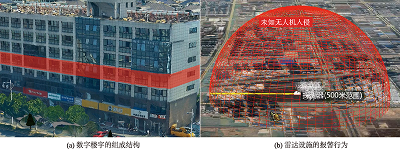
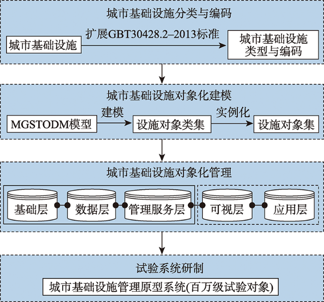
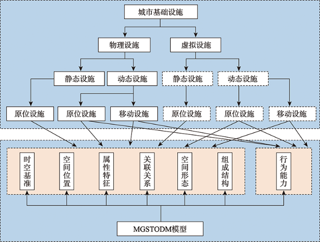
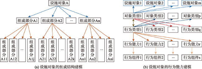
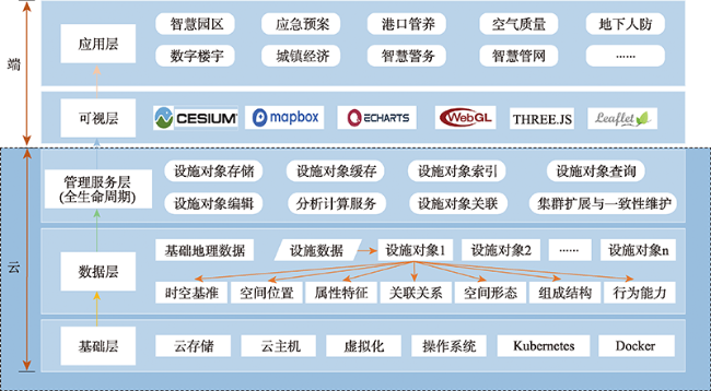
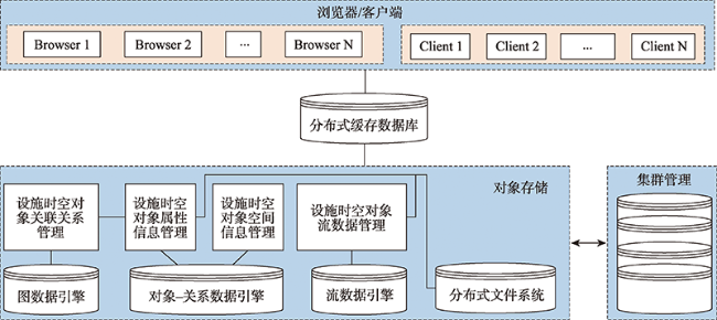
城市基础设施的全方位描述与信息化管理是建设新型智慧城市的重要基础。目前在城市基础设施建模与管理方面,以地图为模板的空间数据模型、传统的面向对象空间数据模型以及实时GIS数据模型不支持对时空对象组成结构、行为能力等要素的描述,无法全面、精细地表达设施对象信息,而计算机、物联网和地理信息系统(Geographic Information System,GIS)领域已有的城市基础设施管理方案忽略了对设施自身信息的管理,无法较好地支持设施对象及其产生数据的一体化管理。针对上述问题,首先通过扩展GBT30428.2-2013标准,完成了城市基础设施的分类与编码;然后基于多粒度时空对象数据模型(Multi-granularity Spatiotemporal Object Data Model, MGSTODM),提出了一种城市基础设施对象化描述模型,支持对城市基础设施信息的全方位描述与表达;在此基础上,提出一种城市基础设施对象化管理方法,设计了相应的技术架构,并研制了基于云存储的百万级城市基础设施对象化管理原型系统。试验结果表明,所提出的城市基础设施对象化描述模型与管理方法具备可行性、有效性和高效性。
杨飞 , 华一新 , 李响 , 李坡 , 杨振凯 , 曹一冰 . 基于多粒度时空对象数据模型的城市基础设施建模与管理[J]. 地球信息科学学报, 2021 , 23(11) : 1984 -1997 . DOI: 10.12082/dqxxkx.2021.210400
The construction of new smart cities has been proposed as an important strategic goal in the 14th Five Year Plan of China. Information management of urban facilities lays a solid foundation for the construction of new smart cities, which relies on the standard, uniform, and detailed modeling and management of such facilities. Current solutions for urban facility modeling are mainly based on three models, i.e., spatial data model using maps as templates, traditional object-oriented spatial data model, and real-time GIS data model. However, limited by the traditional visualization approaches of computers, it is hard for spatial data model using maps as templates to describe and express the hierarchical structure, behavioral interaction, and other necessary information of urban facilities with the data organization method of “geometry & attributes”; traditional object-oriented spatial data model can be used to describe the geometry, attributes, and relationships of urban facilities, but the hierarchical structure and behavioral interaction are still not considered in this model; the object state of real-time GIS data model mainly records traditional spatial and thematic attributes of urban facilities, while lacking the description of the composition structure and behavioral capabilities of temporal and spatial objects. Therefore, all the three models are unable to support the comprehensive and microscopical expression of facility objects. Current related research of urban facility management can be seen mainly in the domains of computer, Internet of Things (IoT) or Geographic Information System (GIS). Research in the domains of computer and IoT mainly focuses on the management of the data generated by urban facilities, ignoring the management of the facilities' own information; real-time GIS in the domain of GIS realizes the management of the information of facility spatiotemporal entities by managing facility data instead of facilities themselves. For example, it expresses taxis and cameras with the real-time data stream of them. Therefore, it still cannot support the management of the facilities' own information. To solve the problems above, firstly the classification and coding of urban facilities was completed by extending the GBT30428.2-2013 standard; then an urban facility object description model based on the Multi-granularity Spatiotemporal Object Data Model (MGSTODM) was proposed, which supports comprehensive description and expression of urban facilities' information; furthermore, an urban facilities management method was proposed, with the design of the corresponding technical architecture and the implementation of the prototype system for the mega level urban facilities management based on cloud storage afterwards. Finally, the proposed object description model and management method of urban infrastructure was proved to be feasible, effective, and efficient.
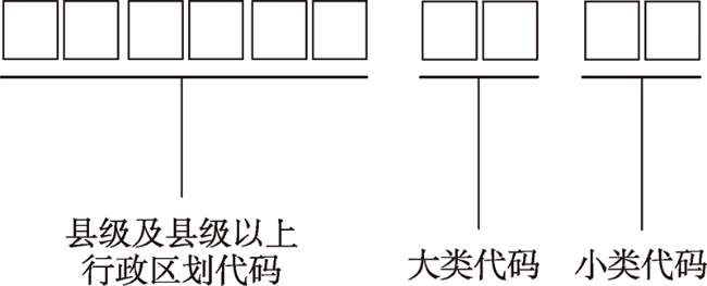
表1 基于扩展GBT30428.2-2013标准的城市基础设施分类与编码Tab. 1 Urban facilities classification and coding based on the extension of GBT30428.2-2013 standard |
| 一级分类 | 一级编码 | 二级分类 | 二级编码 | 三级分类 | 三级编码 | 四级分类与编码 | 实例 |
|---|---|---|---|---|---|---|---|
| 物理设施 | 0 | 静态设施 | 0 | 原位设施 | 0 | 与GBT30428.2-2013一致 | 城市道路、桥梁、建筑等 |
| 动态设施 | 1 | 原位设施 | 0 | 与GBT30428.2-2013一致 | 交通监控摄像头、路灯上的光敏传感器等 | ||
| 移动设施 | 1 | 与GBT30428.2-2013一致 | 车载GPS、船载显示器、无人机上的红外传感器等 | ||||
| 虚拟设施 | 1 | 静态设施 | 0 | 原位设施 | 0 | 与GBT30428.2-2013一致 | 建筑模型、仿真街道等 |
| 动态设施 | 1 | 原位设施 | 0 | 与GBT30428.2-2013一致 | 虚拟摄像头 | ||
| 移动设施 | 1 | 与GBT30428.2-2013一致 | 轨迹模拟器、无人机仿真程序等 |
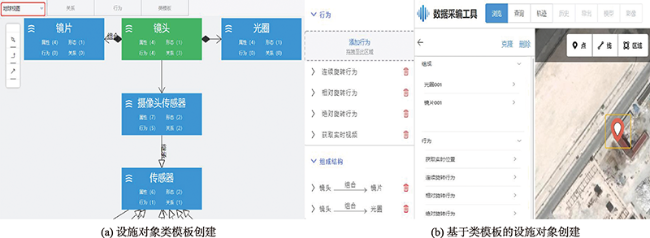
图7 基于交互式工具的城市基础设施对象化建模Fig. 7 Urban facility objects modeling based on interactive tool |
表2 百万级城市基础设施试验对象的统计信息Tab. 2 The statistics of mega level urban facility objects for test |
| 对象大类 | 包含的对象小类数量/个 | 包含的对象数量/个 |
|---|---|---|
| 行政区划 | 3 | 28 |
| 城市建筑 | 1 | 308 592 |
| 城市道路 | 1 | 2194 |
| 社会服务设施 | 15 | 21 621 |
| 社会部件设施 | 97 | 852 473 |
| 合计 | 117 | 1 184 908 |
Tab. 3 The efficiency comparison between MGSTODM-based and Geodatabase-based modeling method |
| 对象大类 | 包含的对象数量/个 | 基于MGSTODM的建模耗时/s | 基于Geodatabase的建模耗时/s |
|---|---|---|---|
| 行政区划 | 28 | 3 | 3 |
| 城市建筑 | 308 592 | 47 540 | 47 248 |
| 城市道路 | 2194 | 362 | 347 |
| 社会服务设施 | 21 621 | 3371 | 3305 |
| 社会部件设施 | 852 473 | 141 154 | 141 098 |
| 合计 | 1 184 908 | 192 430 | 192 001 |
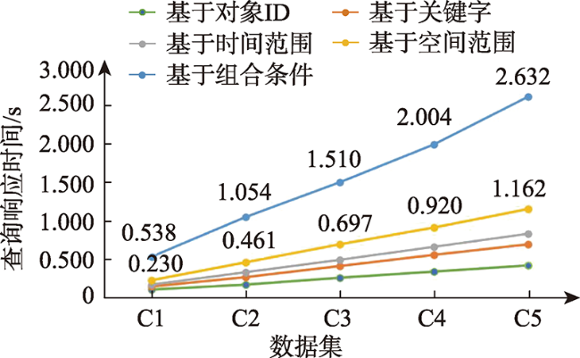
表4 面向系统性能分析的测试数据集Tab. 4 The test data set for system performance analysis |
| 对象大类 | C1 | C2 | C3 | C4 | C5 |
|---|---|---|---|---|---|
| 行政区划 | 5 | 10 | 15 | 20 | 25 |
| 城市建筑 | 52 568 | 105 136 | 157 704 | 210 272 | 262 840 |
| 城市道路 | 352 | 704 | 1056 | 1408 | 1760 |
| 社会服务设施 | 3514 | 7028 | 10 542 | 14 056 | 17 570 |
| 社会部件设施 | 143 561 | 287 122 | 430 683 | 574 244 | 717 805 |
| 合计 | 200 000 | 400 000 | 600 000 | 800 000 | 1 000 000 |
注:C1~C5依次表示设施对象数量为20万、40万、60万、80万和100万时的测试数据集。 |
| [1] |
臧维明, 李月芳, 魏光明. 新型智慧城市标准体系框架及评估指标初探[J]. 中国电子科学研究院学报, 2018, 13(1):1-7.
[
|
| [2] |
郭仁忠, 林浩嘉, 贺彪, 等. 面向智慧城市的GIS框架[J]. 武汉大学学报·信息科学版, 2020, 45(12):1829-1835.
[
|
| [3] |
武芳, 王泽根, 蔡忠亮, 等. 空间数据库原理[M]. 武汉: 武汉大学出版社, 2017.
[
|
| [4] |
龚健雅, 李小龙, 吴华意. 实时GIS时空数据模型[J]. 测绘学报, 2014, 43(3):226-232,275.
[
|
| [5] |
|
| [6] |
|
| [7] |
|
| [8] |
吴信才. 空间数据库[M]. 北京: 科学出版社, 2020.
[
|
| [9] |
|
| [10] |
华一新, 周成虎. 面向全空间信息系统的多粒度时空对象数据模型描述框架[J]. 地球信息科学学报, 2017, 19(9):1142-1149.
[
|
| [11] |
周成虎. 全空间地理信息系统展望[J]. 地理科学进展, 2015, 34(2):129-131.
[
|
| [12] |
华一新. 全空间信息系统的核心问题和关键技术[J]. 测绘科学技术学报, 2016, 33(4):331-335.
[
|
| [13] |
杨飞, 华一新, 李响, 等. 多粒度时空对象行为驱动的传感设施接入方法[J]. 测绘科学技术学报, 2020, 37(5):537-544.
[
|
| [14] |
中国国家标准化管理委员会. 数字化城市管理信息系统-第2部分:管理部件和事件(GBT30428.2)[S]. 2013.
[
|
| [15] |
张政, 华一新, 张晓楠, 等. 多粒度时空对象关联关系基本问题初探[J]. 地球信息科学学报, 2017, 19(9):1158-1163.
[
|
| [16] |
王培. 多粒度时空对象空间形态理论和方法研究[D]. 郑州:战略支援部队信息工程大学, 2019:18-23.
[
|
| [17] |
李锐, 石佳豪, 董广胜, 等. 多粒度时空对象组成结构表达研究[J]. 地球信息科学学报, 2021, 23(1):113-123.
[
|
| [18] |
丁小辉, 张树清, 陈祥葱, 等. 时空对象行为分类与形式化表达[J]. 地球信息科学学报, 2017, 19(9):1195-1200.
[
|
| [19] |
曹一冰, 华一新, 郭邵萌. 多粒度时空对象行为特征的描述方法研究[J]. 地理信息世界, 2018, 25(2):23-29.
[
|
| [20] |
|
| [21] |
北京数字空间科技有限公司. 地理国情监测云平台[EB/OL]. http://www.dsac.cn, 2021-04-02.
[ Beijing Digital View Technology Co., Ltd.. Geographical Information Monitoring Cloud Platform[EB/OL]. http://www.dsac.cn, 2021-04-02.]
|
| [22] |
成都比格图数据处理有限公司. 比格图[EB/OL].http://www.bigemap.com/index.html 2021-04-02.
[ Chengdu BIGEMAP Data Processing Co., Ltd.. BIGEMAP[EB/OL]. http://www.bigemap.com/index.html, 2021-04-02.]
|
/
| 〈 |
|
〉 |
