
泛北极地区植被数据集与制图:回顾与展望
|
薛守业(1997— ),男,甘肃平凉人,硕士生,从事北极植被变化研究。E-mail: xuesye@163.com |
收稿日期: 2021-06-03
要求修回日期: 2021-07-19
网络出版日期: 2022-05-25
基金资助
国家自然科学基金项目(41941015)
国家自然科学基金项目(32061143032)
中国科学院西部之光项目(2020)
甘肃省优秀研究生“创新之星”项目(2021CXZX-623)
版权
Vegetation Data and Classification in Pan-Arctic Terrestrial Regions: Retrospective and Perspective
Received date: 2021-06-03
Request revised date: 2021-07-19
Online published: 2022-05-25
Supported by
National Natural Science Foundation of China(41941015)
National Natural Science Foundation of China(32061143032)
West Light Foundation of the Chinese Academy of Sciences(2020)
Outstanding Graduate Students “The star of innovation”Foundation of Gansu Province, China(2021CXZX-623)
Copyright
泛北极地区位于北半球高纬度地区,主要属于低温限制型生态系统,因而泛北极地区植被对全球变暖敏感。要明确泛北极地区陆地生态系统对全球变暖响应过程和机理,就需要高精度的植被类型分类数据作为基础资料。但是,目前泛北极地区植被数据的结果还不完善。为更好地认识泛北极地区植被类型分类的现状、发展历史和未来研究方向,本文综述了泛北极地区植被类型制图的数据来源、植被类型划分方法和植被类型制图研究方法。总体而言,泛北极地区的植被调查从20世纪20年代就陆续开展,目前部分区域尺度上的地表覆盖类型的结果,但具体的植被类型制图工作还存在一系列难题。主要原因包括植被野外调查实测数据较少和分布不均、植被类型分类标准不一、苔原植被群落的异质性大、制图技术和分类算法优化困难等。因此,在下一步泛北极植被类型制图工作中,需要制定标准化分类策略,规范数据获取及数据库的整理工作,并发展新的制图方法,从而促进植被类型制图研究工作。
薛守业 , 徐海燕 , 甘子鹏 , 梁冰妍 , 种碧莹 , 王莉 , 张博 , 李小明 , 李莉莎 , 毛楠 , 刘桂民 , 吴晓东 . 泛北极地区植被数据集与制图:回顾与展望[J]. 地球信息科学学报, 2022 , 24(3) : 421 -436 . DOI: 10.12082/dqxxkx.2022.210311
Pan-Arctic area belongs to the high latitudes, and the vegetation in Pan-Arctic mainly belongs to the temperature-limited ecosystem, and thus the vegetation is sensitive to global warming. A vegetation atlas with high accuracy is the scientific basis for the study of response of vegetation to climate change and its driving mechanisms. However, there is a large room for improvement of vegetation type classification in the Pan-Arctic regions. For a better knowledge of the current status, history, and future trends in the vegetation mapping, we comprehensively reviewed the data resources, approaches, and methods of vegetation type classification in the Pan-Arctic region. Overall, the field survey of vegetation began in the 1920s, and there have been some land cover type data at the regional scale. However, there are still many challenges for Pan-Arctic vegetation type mapping, which can be attributed to several reasons such as differences in field survey data, standards for the land cover type classification, and the heterogeneities in tundra ecosystem, and differences in mapping methods and difficulties of optimizing algorithm. In the future work, more attentions should be paid to standard classification rules, and standard dataset preparation and integration, which will benefit the development of new methods for vegetation type mapping in the Pan-Arctic area.
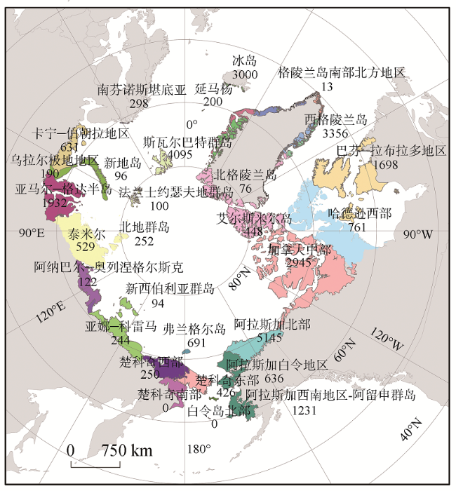
图2 北极植被档案馆AVA样点分布注:来源于https://www.caff.is/flora-cfg/ava/vegetation-plot-data。 Fig. 2 AVA plot data distribution |
表1 AVA数据库名单(部分)Tab. 1 List of AVA (PART) |
| 名称 | GIVD-ID | 样点区域 | 建立时间 | 注册时间 | 更新时间 | 样点数量/个 |
|---|---|---|---|---|---|---|
| Wetland Vegetation Database of Baikal Siberia | AS-RU-001 | 俄罗斯西伯利亚贝加尔湖 | 2002 | 2011-04-07 | 2015-09-23 | 2806 |
| Database of Siberian Vegetation | AS-RU-002 | 俄罗斯西伯利亚 | 1994 | 2012-03-14 | 2018-11-09 | 30 611 |
| Database of the University of Münster- Biodiversity and Ecosystem Research Group's Vegetation Research in Western Siberia and Kazakhstan | AS-RU-004 | 俄罗斯西西伯利亚 | 2002 | 2015-08-25 | 2015-09-23 | 440 |
| Nenets Tundra | AS-RU-005 | 俄罗斯亚马尔地区 | 2014 | 2017-04-06 | 2019-04-04 | 1240 |
| Vegetation Database of Québec | NA-CA-002 | 加拿大魁北克 | 1986 | 2010-10-22 | 2015-09-23 | 28 425 |
| Vegetation Database of Greenland | NA-GL-001 | 格陵兰岛 | 2013 | 2015-08-08 | 2016-01-23 | 664 |
| the Alaska Arctic Vegetation Achieve | NA-US-014 | 美国阿拉斯加 | 2013 | 2013/4/2 | 2018/11/9 | 3026 |
注:GIVD-ID:全球植被数据库索引。表中注册时间指注册GIVD数据库的时间。 |
表2 基于群落结构的植被类型分类系统Tab. 2 Vegetation types classification system based on Community structure |
| 基本形态单元 | 基本群落组成 | 二级分类 | CAVM分类水平[19]/AATVMⅡ级分类水平[101] | |
|---|---|---|---|---|
| 植被 | 苔原 | 禾本科植物苔原 | 隐花植物,丛生草苔原 | 隐花植物苔原 |
| 矮灌木(dwarf-shrub)苔原 | 匍匐矮灌木苔原 | |||
| 半匍匐矮灌木苔原 | ||||
| 直立灌木 | ||||
| 低灌木(Low-shrub)苔原 | 低灌木苔原 | |||
| 苔藓植物苔原 | 苔藓植物苔原 | 苔藓植物苔原 | ||
| 湿地 | 草本科植物湿地 | 禾本科植物湿地 | 莎草植物湿地 | |
| 灌木植物湿地 | 矮灌木植物湿地 | |||
| 低灌木植物湿地 | ||||
| 苔藓植物湿地 | 苔藓植物湿地 | 苔藓植物湿地 | ||
| 非植被 | 裸地 | 裸地 | 有植被覆盖的裸地 | 隐花植物裸地 |
| 草本植物裸地 | ||||
| 矮灌木裸地 | ||||
| 植被覆盖度极小的基岩 | 酸性基岩 | |||
| 非酸性基岩 | ||||
| 水体 | 水体 | 水体 | 海水 | |
| 淡水 | ||||
| 冰雪/冰川 | 冰雪/冰川 | 冰雪/冰川 | 冰雪/冰川 |
| [1] |
|
| [2] |
|
| [3] |
|
| [4] |
|
| [5] |
|
| [6] |
|
| [7] |
|
| [8] |
|
| [9] |
|
| [10] |
|
| [11] |
|
| [12] |
|
| [13] |
|
| [14] |
|
| [15] |
|
| [16] |
|
| [17] |
|
| [18] |
|
| [19] |
|
| [20] |
|
| [21] |
|
| [22] |
|
| [23] |
|
| [24] |
|
| [25] |
|
| [26] |
|
| [27] |
|
| [28] |
|
| [29] |
|
| [30] |
|
| [31] |
|
| [32] |
|
| [33] |
|
| [34] |
|
| [35] |
|
| [36] |
|
| [37] |
|
| [38] |
|
| [39] |
|
| [40] |
|
| [41] |
|
| [42] |
|
| [43] |
|
| [44] |
|
| [45] |
|
| [46] |
|
| [47] |
|
| [48] |
|
| [49] |
|
| [50] |
|
| [51] |
|
| [52] |
|
| [53] |
|
| [54] |
|
| [55] |
|
| [56] |
|
| [57] |
|
| [58] |
|
| [59] |
|
| [60] |
|
| [61] |
|
| [62] |
|
| [63] |
|
| [64] |
|
| [65] |
|
| [66] |
|
| [67] |
|
| [68] |
|
| [69] |
|
| [70] |
|
| [71] |
|
| [72] |
|
| [73] |
|
| [74] |
|
| [75] |
|
| [76] |
|
| [77] |
|
| [78] |
|
| [79] |
|
| [80] |
|
| [81] |
|
| [82] |
|
| [83] |
|
| [84] |
|
| [85] |
|
| [86] |
|
| [87] |
|
| [88] |
|
| [89] |
|
| [90] |
|
| [91] |
|
| [92] |
|
| [93] |
|
| [94] |
|
| [95] |
|
| [96] |
|
| [97] |
|
| [98] |
|
| [99] |
|
| [100] |
|
| [101] |
|
| [102] |
|
| [103] |
|
| [104] |
|
| [105] |
|
| [106] |
|
| [107] |
|
| [108] |
|
| [109] |
|
| [110] |
|
| [111] |
|
| [112] |
|
| [113] |
|
| [114] |
|
| [115] |
|
| [116] |
|
| [117] |
Federal Geographic Data Committee V S. United States National Vegetation Classification Database[DS]. 2019.
|
| [118] |
|
| [119] |
|
| [120] |
|
| [121] |
|
| [122] |
|
| [123] |
|
| [124] |
|
| [125] |
|
| [126] |
|
| [127] |
|
| [128] |
|
| [129] |
|
| [130] |
|
| [131] |
|
| [132] |
|
| [133] |
|
| [134] |
|
/
| 〈 |
|
〉 |