
基于潮汐动态淹没过程的长江口潮滩地形信息反演研究
|
章 敏(1997— ),男,安徽铜陵人,硕士生,研究方向为海岸带遥感。E-mail: N195527044@fzu.edu.cn |
收稿日期: 2021-07-27
要求修回日期: 2021-09-01
网络出版日期: 2022-05-25
基金资助
国家自然科学基金项目(41801393)
中央引导地方发展专项(2017L3012)
版权
Topographic Retrieval of the Tidal Flats in the Yangtze Estuary based on the Dynamic Tidal Submergence
Received date: 2021-07-27
Request revised date: 2021-09-01
Online published: 2022-05-25
Supported by
National Natural Science Foundation of China(41801393)
Special Project of Central Government Guiding Local Development(2017L3012)
Copyright
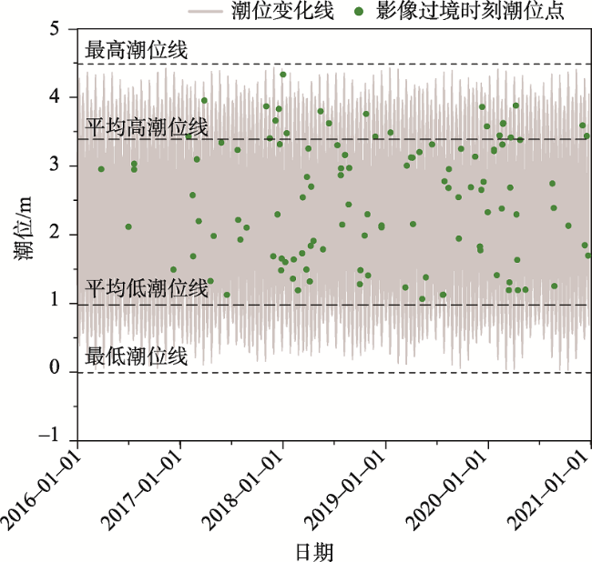
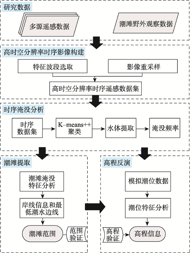
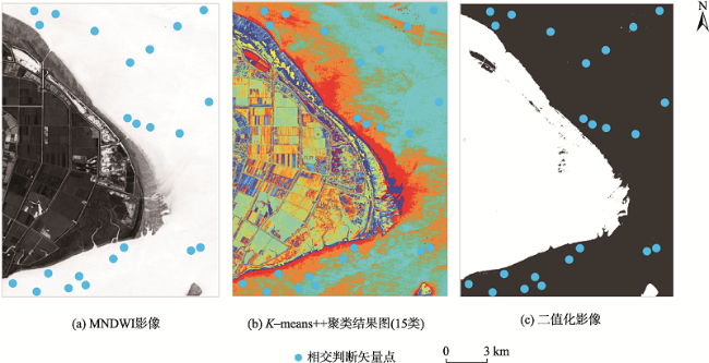
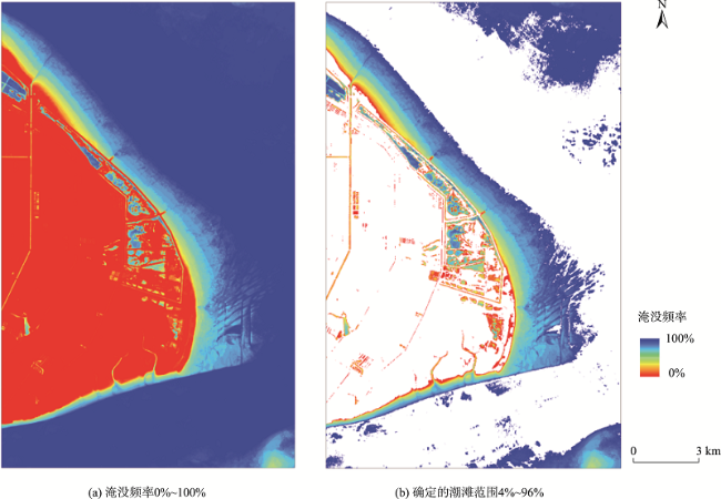
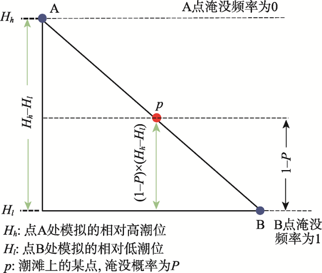
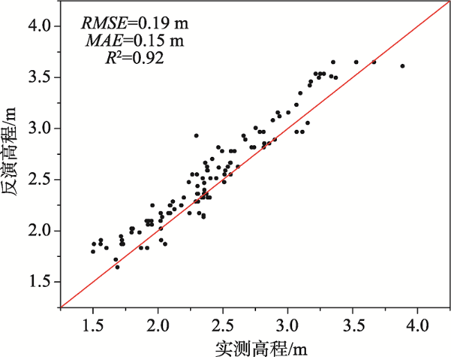
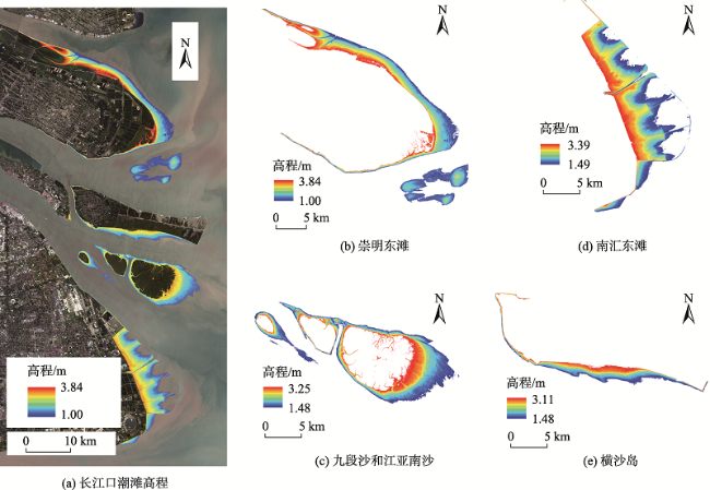
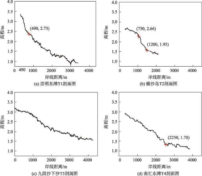
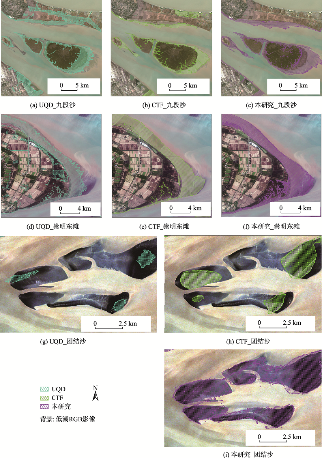
潮滩是陆地与海洋之间重要的生态过渡地带,具有复杂的生态过程和重要的服务功能。受陆海交互作用及人类活动的影响,潮滩处于高度动态变化过程中,而传统测绘技术受到潮滩可达性影响无法快速获取潮滩地形信息。为解决潮滩高程数据获取困难的问题,本文提出一种基于潮汐动态淹没过程和时序遥感影像的潮滩地形信息提取算法,利用K-means++聚类方法实现水域提取,并通过时序淹没特征计算潮滩淹没频率提取潮滩范围信息,最终综合区域潮汐特征反演潮滩地形。研究以崇明东滩为例,利用2016—2020年所有可用Sentinel-2和Landsat-8时序遥感影像,实现潮滩范围提取与高程反演,并通过实测高程数据进行精度验证。研究结果表明,潮滩范围提取总体精度为97.73%,F1_score为0.98;高程反演平均绝对误差为0.15 m,潮滩高程的反演精度与可用影像的数量呈正相关。研究利用该算法进一步反演长江口地区主要潮滩地形特征,结果表明区域内潮滩面积为346.93 km2,高程范围为1.00~3.84 m,且与现有潮滩范围数据集相比,本研究提取的长江口潮滩范围更为完整。该算法为潮滩地形的快速反演提供了可能,对潮滩资源动态监测和管理具有重要意义。
章敏 , 吴文挺 , 汪小钦 , 孙玉 . 基于潮汐动态淹没过程的长江口潮滩地形信息反演研究[J]. 地球信息科学学报, 2022 , 24(3) : 583 -596 . DOI: 10.12082/dqxxkx.2022.210429
Tidal flats are important transitional zones between terrestrial and marine ecosystems and have complicated ecological processes and essential ecosystem services. Tidal flats are highly dynamic under the influences of land-sea interactions and anthropogenic activities. Limited by the accessibility, it is difficult to map the tidal flat using traditional survey. To solve the difficulty in obtaining tidal flat elevation data, a tidal flat elevation inversion model suitable for large-scale with high accuracy is needed. In this study, we proposed an algorithm incorporating tidal submergence and time-series Remote Sensing (RS) data to map the topography of tidal flats. We used Chongming Dongtan as an example and further extended the results to the whole Yangtze Estuary. Firstly, the K-means++ clustering was employed to extract the inundation extent of tidal. Then, the frequency of tidal inundation of each pixel was calculated from the time series RS data. Finally, the tidal flat topography was retrieved based on the regional tidal frequency. All available Sentinel-2 and Landsat-8 images from 2016 to 2020 were used to build the time-series dynamic of tidal flats to map the topography. Verified by the in-situ data, the results showed that the total accuracy and F1-score of the inundation extent extraction of the tidal flats were 97.73% and 0.98, respectively. The average absolute error of elevation inversion was 0.15 m. The accuracy of tidal flat elevation was positively correlated with the number of available images. The total area of tidal flats was 346.93 km2 with an elevation range of 1.00~3.84 m. The tidal flats in the Yangtze Estuary were mainly distributed in Chongming Dongtan, Jiuduansha, Hengsha Dongtan, Nanhui Biantan, and Tuanjiesha. Among them, Nanhui beach had the largest area (107.44 km2), while Chongming east beach had the largest elevation difference (2.84 m). The distribution status of tidal flat was mainly affected by sediment hydrodynamics, vegetation, and human engineering activities. Compared with the existing dataset, our results showed a more robust capacity in the inundation extent extraction of tidal flats. With the increasing number of effective observations and tidal level information from time-series RS images in coastal areas, the extraction accuracy of tidal flat information could be further improved. The proposed algorithm has a great potential in rapid mapping of tidal flat topography and is of great significance for the dynamic monitoring and management of tidal flat resources.
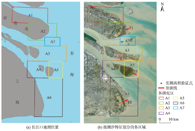
表1 各区域影像数量及潮位信息Tab. 1 The number of images and tidal range of the subareas |
| 区域 | 数量/景 | 相对最高潮/m | 相对最低潮/m |
|---|---|---|---|
| A1 | 115 | 3.94 | 0.92 |
| A2 | 101 | 3.95 | 1.08 |
| A3 | 81 | 3.39 | 1.33 |
| A4 | 90 | 3.18 | 1.41 |
| A5 | 111 | 3.21 | 1.37 |
| A6 | 104 | 3.34 | 1.39 |
| A7 | 86 | 3.47 | 1.41 |
注:潮位高程基准为吴淞高程。 |
表2 潮滩范围提取验证Tab. 2 the verification of extent mapping of tidal flats |
| 类别 | 潮滩 | 非潮滩 | 合计 | 用户精度/% | F1_score | 总体精度/% |
|---|---|---|---|---|---|---|
| 潮滩 | 300 | 1 | 301 | 99.67 | 0.98 | 97.73 |
| 非潮滩 | 12 | 261 | 273 | 95.60 | 0.97 | |
| 合计 | 312 | 262 | 574 | |||
| 生产精度/% | 96.15 | 99.62 |
图9 长江口各区域潮滩高程分布特征。Fig. 9 The spatial distribution of the retrieval elevation of the flats in the Yangtze Estuary |
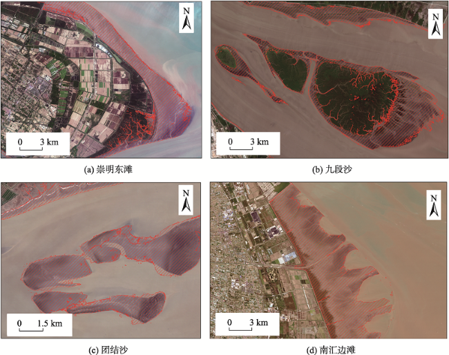
表3 各潮滩面积和高程范围Tab. 3 The area and elevation range of each tidal flat |
| 潮滩区域 | 面积/km2 | 高程范围/m |
|---|---|---|
| 崇明岛 | 97.59 | 1.00~3.84 |
| 团结沙 | 34.56 | 1.36~2.66 |
| 横沙岛 | 29.94 | 1.48~3.11 |
| 九段沙 | 68.72 | 1.48~3.25 |
| 江亚南沙 | 8.68 | 1.48~3.13 |
| 南汇东滩 | 107.44 | 1.49~3.39 |
| 合计 | 346.93 | 1.00~3.84 |
表4 各高程范围下的潮滩面积Tab. 4 Tidal flat area of each elevation range |
| 高程范围/m | 面积/km2 | 高程范围/m | 面积/km2 | |
|---|---|---|---|---|
| 1.00~1.20 | 4.61 | 2.60~2.80 | 23.05 | |
| 1.20~1.40 | 21.69 | 2.80~3.00 | 26.14 | |
| 1.40~1.60 | 39.66 | 3.00~3.20 | 29.33 | |
| 1.60~1.80 | 44.76 | 3.20~3.40 | 15.80 | |
| 1.80~2.00 | 39.40 | 3.40~3.60 | 5.79 | |
| 2.00~2.20 | 32.35 | 3.60~3.80 | 9.50 | |
| 2.20~2.40 | 28.02 | 3.80~3.84 | 3.42 | |
| 2.40~2.60 | 23.92 |
表5 影像数量差异对比Tab. 5 Comparison of the number of images |
| 影像数量/景 | R2 | RMSE/m |
|---|---|---|
| 101 | 0.92 | 0.19 |
| 60 | 0.86 | 0.21 |
| 32 | 0.83 | 0.32 |
| [1] |
韩倩倩, 牛振国, 吴孟泉, 等. 基于潮位校正的中国潮间带遥感监测及变化[J]. 科学通报, 2019, 64(4):456-473.
[
|
| [2] |
|
| [3] |
|
| [4] |
|
| [5] |
|
| [6] |
|
| [7] |
|
| [8] |
|
| [9] |
吴一全, 刘忠林. 遥感影像的海岸线自动提取方法研究进展[J]. 遥感学报, 2019, 23(4):582-602.
[
|
| [10] |
李天祺, 王建超, 吴芳, 等. 基于多算法水边线提取的潮滩DEM构建[J]. 国土资源遥感, 2021, 33(1):38-44.
[
|
| [11] |
|
| [12] |
刘杰, 程海峰, 韩露, 等. 流域水沙变化和人类活动对长江口河槽演变的影响[J]. 水利水运工程学报, 2021(2):1-9.
[
|
| [13] |
陈吉余, 沈焕庭, 恽才兴. 长江河口动力过程和地貌演变[M]. 上海: 上海科学技术出版社, 1988.
[
|
| [14] |
王浩斌. 风暴对长江口悬沙浓度的影响及其动力机制[D]. 上海:华东师范大学, 2018.
[
|
| [15] |
袁爽. 近35年长江口潮滩演变遥感研究——以崇明东滩与九段沙为例[D]. 南昌:江西理工大学, 2018.
[
|
| [16] |
中华人民共和国水利部. 中国河流泥沙公报(2019)[M]. 北京: 中国水利水电出版社,2020.
[ Ministry of Water Resources of China. China river water and sediment bulletin (2019)[M]. Beijing: China Water Resources and Hydropower Press, 2020. ]
|
| [17] |
范吉庆. 台风对长江口潮间带湿地沉积动力过程的影响[D]. 上海:华东师范大学, 2019.
[
|
| [18] |
欧洲航天局. 哥白尼开放存取中心[EB/OL]. https://scihub.copernicus.eu/dhus/#/home/ 2021-03-03.
[ European Space Agency. Copernicus Open Access Hub[EB/OL]. https://scihub.copernicus.eu/dhus/#/home/ 2021-03-03.]
|
| [19] |
美国地质勘探局.地球探索者平台[EB/OL]. http://earthexplorer.usgs.gov/ 2021-03-09.
[ United States Geological Survey. Earth Explorer[EB/OL]. http://earthexplorer.usgs.gov/ 2021-03-09.]
|
| [20] |
刘向阳. 基于遥感水边线的环渤海地区潮滩研究[D]. 烟台:中国科学院烟台海岸带研究所, 2016.
[
|
| [21] |
|
| [22] |
沈芳, 郜昂, 吴建平, 等. 淤泥质潮滩水边线提取的遥感研究及DEM构建——以长江口九段沙为例[J]. 测绘学报, 2008, 37(1):102-107.
[
|
| [23] |
|
| [24] |
|
| [25] |
|
| [26] |
|
| [27] |
张长宽, 徐孟飘, 周曾, 等. 潮滩剖面形态与泥沙分选研究进展[J]. 水科学进展, 2018, 29(2):269-282.
[
|
| [28] |
|
| [29] |
龚政, 白雪冰, 靳闯, 等. 基于植被和潮动力作用的潮滩剖面演变数值模拟[J]. 水科学进展, 2018, 29(6):877-886.
[
|
| [30] |
戴志军, 陈吉余, 程和琴, 等. 南汇边滩的沉积特征和沉积物输运趋势[J]. 长江流域资源与环境, 2005, 14(6):63-67.
[
|
| [31] |
罗锋, 蒋冰, 董冰洁, 等. 潮滩剖面形态特征及演变[J]. 科技导报, 2018, 36(14):35-41.
[
|
| [32] |
吴小根, 王爱军. 人类活动对苏北潮滩发育的影响[J]. 地理科学, 2005, 25(5):614-620.
[
|
| [33] |
路兵, 蒋雪中. 滩涂围垦对崇明东滩演化影响的遥感研究[J]. 遥感学报, 2013, 17(2):335-349.
[
|
| [34] |
朱绳祖, 张国安, 张卫国, 等. 近期长江口崇明岛周边岸滩沉积特征及影响机制[J]. 长江流域资源与环境, 2019, 28(10):2441-2451.
[
|
| [35] |
|
/
| 〈 |
|
〉 |