
城市地表热辐射方向性研究进展综述
|
韦乐田(1996— ),女,浙江杭州人,硕士生,主要从事热红外定量遥感研究。E-mail: weiletian19@mails.ucas.ac.cn |
收稿日期: 2021-07-23
修回日期: 2021-09-28
网络出版日期: 2022-06-25
基金资助
国家自然科学基金项目(41971319)
版权
Review of Urban Thermal Radiation Anisotropy
Received date: 2021-07-23
Revised date: 2021-09-28
Online published: 2022-06-25
Supported by
National Natural Science Foundation of China(41971319)
Copyright
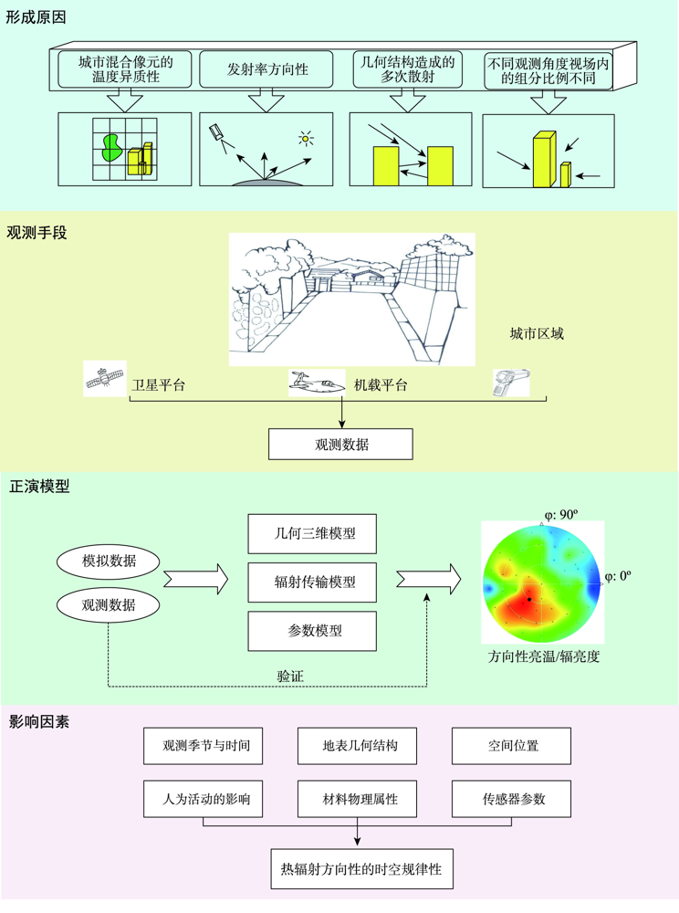
热辐射方向性是指从不同方向观测同一目标地物时,测得的热辐射值各异的现象,通常体现为方向性辐亮度或亮温各异。随着高空间分辨率遥感数据的出现,面对高精度地表温度产品的需求,热辐射方向性效应不可忽视,如今已成为热红外遥感重点关注的问题之一。对于物质组成不均一、几何结构复杂的城市地表来说,热辐射方向性尤为显著。本文整理、分析了在城市地区开展的一系列热辐射方向性观测试验和正演模型,其中也包括一些对地表温度真值的有益探索;并对城市热辐射方向性强度的影响因素进行了归纳,包括观测季节与时间、地表几何结构、材料自身的物理属性、观测角度、视场角等,这些因素会使热辐射方向性的强度呈现出一定的时空规律性。最后,针对提高城市地表温度的反演精度、如何更好地开展城市热辐射方向性研究提出了5点展望。
韦乐田 , 姜小光 , 吴骅 , 茹晨 . 城市地表热辐射方向性研究进展综述[J]. 地球信息科学学报, 2022 , 24(4) : 617 -630 . DOI: 10.12082/dqxxkx.2022.210422
Thermal radiation directionality refers to the phenomenon that thermal radiation values measured from different observation directions are different for a certain surface object, which is usually reflected in different directional radiance or different brightness temperature. With the emergence of high spatial resolution remotely sensed data and the demand for high-precision surface temperature products, the effect of thermal radiation anisotropy cannot be ignored. Now it has become one of the hottest issues concerned widely in the thermal infrared field. The thermal anisotropy is more obvious for the urban surface with diverse surface features and complex geometric structure. This article describes three observational experiments, including ground observation experiment, airborne observation experiment, and space observation experiment. These three methods have their own advantages and disadvantages and can be used in different situations. The observation data that represents the reality of urban radiation directionality often shows obvious thermal radiation anisotropy in urban areas during the daytime. In addition, a series of forward models of thermal radiation anisotropy carried out in urban areas are categorized and analyzed. These models can be divided into three categories: geometric three-dimensional model, radiative transfer model, and parameter model. According to existing academic papers, in-situ observation data are usually used to estimate the coefficients and verify the simulation accuracy of forward models. By combining these two approaches, observations and models, some scholars have made some achievements in this field. The purpose of studying thermal radiation anisotropy in urban areas is to obtain land surface parameters with higher accuracy. So, the exploration of true values of urban surface temperature are also included in this study. Furthermore, the impact factors of thermal radiation anisotropy are summarized, such as observation season and time, surface geometry, physical properties of surface materials, observation angle, FOV of sensor, etc. which influence the spatial and temporal patterns of intensity of thermal radiation anisotropy. At last, for the ultimate goal of improving the retrieval accuracy of urban surface temperature, five prospects are put forward: using high-resolution thermal infrared sensors to get the data of urban thermal background field, carrying out more thermal infrared multi-angle remote sensing experiments from different platforms, improving understanding of the mechanism of thermal radiation of non-isothermal heterogeneous pixels, performing validation of urban surface temperature, applying the research results into practice such as angle correction of satellite temperature products.
表1 常见的热辐射方向性模型Tab. 1 Commonly used thermal radiation anisotropy models |
| 模型 | 假设 | 优点 | 不足 | 适用场景 | |
|---|---|---|---|---|---|
| 几何三 维模型 | GUTA-sparse[39] | 建筑等高、方向随机 分布 | 将核驱动形式引入模型,线性结构使之更为灵活 | 至少需要4个方向的观测数据 | 建筑高距比小于1的稀疏城市表面 |
| GUTA-osg[40] | 建筑等高、方向随机 分布 | 运用布尔模型解决建筑物阴影重叠的情况 | 没有考虑多重散射和垂直墙面上的阴影 | 建筑高距比小于2的稀疏城市表面 | |
| GUTA-dense[41] | 建筑等高、方向随机 分布 | 运用布尔模型解决建筑物阴影重叠的情况 | 没有考虑多重散射和发射率的方向性 | 建筑高距比大于2时,需结合GUTA-osg和GUTA-dense模拟 | |
| SUM[23] | 建筑等高且屋顶均 水平 | 可以计算任一表面在观测视场角中所占的面积比例和光照情况 | 需要输入地表组分的温度和观测角度等信息,使其应用大大受限 | 简化的城市地表 | |
| SUMVEG[42] | 阴影叶片具有相同程度的阴影,接收的辐射值相同 | 使用光线追踪法和间隙概率法来估计叶片在视场中的辐射贡献 | 需要输入地表组分的温度和植被的生物物理属性等大量信息 | 植被冠层和简化的城市地表 | |
| 辐射传 输模型 | SOLENE[43,44] | 对流热传递系数是恒定的;建筑内部温度是恒定的 | 可用于计算几何形态较复杂的城市热辐射 | 计算时间长,验证难度大 | 晴朗无云的大气环境,适合微小尺度的热辐射分析 |
| TUF-3D[47] | 表面由平行的平面组成;能被细分为相同的方形斑块 | 相较于其它辐射传输模型,模型输入较少 | 对建筑的几何形态过于理想化;对流模拟过程较粗糙 | 可模拟复杂的城市地表 | |
| TITAN[49] | 建筑垂直于地面且等高;表面是朗伯体 | 可以得到总信号的所有辐射贡献 | 需要输入几何场景和大气等大量信息 | 简化的城市地表 | |
| DART[50,51] | 将体素作为辐射相互作用的存储单元 | 可以直接模拟大气辐射传输;用户界面操作方便;维护更新及时 | 输入参数多,计算时间长 | 可模拟复杂的城市地表 | |
| ATIMOU[52] | 建筑垂直于地面且等高;表面是朗伯体平面 | 能够给出LST的解析解,对于反演高精度的城市LST是一个有益的尝试 | 建筑对称等高、街道无限长等假设限制了其实际 应用 | 简化的城市地表 | |
| 参数 模型 | RL[17] | 同一水平冠层的散射体之间没有相互遮挡 | 关注热点效应 | 不考虑阴影效应;在夜间的拟合效果不佳;非线性形式限制其广泛运用 | |
| Vinnikov 三核驱动模型[36] | 模型由各向同性核、发射率核和太阳核构成 | 低LAI的植被冠层的模拟效果好 | 模拟热点效应能力弱 | ||
| TIR-BRDF模型[54,55] | 冠层由叶片、光照土壤和阴影土壤组成 | 观测天顶角小于45°时,TIR-BRDF的模拟效果好 | 至少需要4个方向的观测数据 | ||
| GUTA-T[65] | 建筑等高、方向随机 分布 | 太阳天顶角约45°时,模拟效果好 | 仅适用于太阳天顶角30~50°的情况;没有考虑热滞后效应 | ||
表2 城市区域热辐射方向性的影响因素总结Tab. 2 Summary of influence factors on urban thermal radiation anisotropy |
| 影响因素 | 主要参数 |
|---|---|
| 观测时间 | 季节、日尺度 |
| 地表几何结构 | 建筑高度、密度 |
| 高宽比(H/W) | |
| 观测表面方向、倾角 | |
| 天空可视因子 | |
| 材料物理属性 | 反射率 |
| 发射率 | |
| 热导率 | |
| 空间位置 | 观测距离 |
| 观测天顶角、方位角 | |
| 太阳天顶角、方位角 | |
| 传感器参数 | 视场角 |
| 空间分辨率 |
| [1] |
李召良, 段四波, 唐伯惠, 等. 热红外地表温度遥感反演方法研究进展[J]. 遥感学报, 2016,20(5):899-920.
[
|
| [2] |
毛克彪, 杨军, 韩秀珍, 等. 基于深度动态学习神经网络和辐射传输模型地表温度反演算法研究[J]. 中国农业信息, 2018,30(5):47-57.
[
|
| [3] |
阎广建, 李小文, 王锦地, 等. 宽波段热红外方向性辐射建模[J]. 遥感学报, 2000,4(3):189-193.
[
|
| [4] |
徐希孺, 范闻捷, 陈良富. 开放的复杂目标热辐射特性的矩阵表达式[J]. 中国科学(D辑:地球科学), 2001,31(12):1046-1051.
[
|
| [5] |
|
| [6] |
马伟, 陈云浩, 占文凤, 等. 城市模拟目标的3维热辐射方向性模型[J]. 遥感学报, 2013,17(1):62-76.
[
|
| [7] |
|
| [8] |
|
| [9] |
周纪, 陈云浩, 李京, 等. 城市区域热辐射方向性研究进展[J]. 地球科学进展, 2009,24(5):497-505.
[
|
| [10] |
|
| [11] |
|
| [12] |
|
| [13] |
|
| [14] |
|
| [15] |
|
| [16] |
|
| [17] |
|
| [18] |
|
| [19] |
|
| [20] |
|
| [21] |
|
| [22] |
|
| [23] |
|
| [24] |
占文凤, 陈云浩, 马伟, 等. 城市目标方向亮温观测的视场效应分析[J]. 遥感学报, 2010,14(2):372-386.
[
|
| [25] |
|
| [26] |
|
| [27] |
|
| [28] |
|
| [29] |
|
| [30] |
余涛, 田启燕, 顾行发, 等. 城市简单目标方向亮温研究[J]. 遥感学报, 2006,10(5):661-669.
[
|
| [31] |
刘强, 肖青, 刘志刚, 等. 黑河综合遥感联合试验中机载WiDAS数据的预处理方法[J]. 遥感技术与应用, 2010,25(6):797-804.
[
|
| [32] |
|
| [33] |
|
| [34] |
李召良,
[
|
| [35] |
阎广建, 姜海兰, 闫凯, 等. 多角度光学定量遥感[J]. 遥感学报, 2021,25(1):83-108.
[
|
| [36] |
|
| [37] |
|
| [38] |
|
| [39] |
|
| [40] |
|
| [41] |
|
| [42] |
|
| [43] |
|
| [44] |
|
| [45] |
|
| [46] |
|
| [47] |
|
| [48] |
|
| [49] |
|
| [50] |
|
| [51] |
|
| [52] |
|
| [53] |
|
| [54] |
彭菁菁, 刘强, 柳钦火, 等. 多角度热红外亮温值的模型拟合与应用[J]. 红外与毫米波学报, 2011,30(4):361-365,371.
[
|
| [55] |
|
| [56] |
|
| [57] |
|
| [58] |
|
| [59] |
|
| [60] |
|
| [61] |
|
| [62] |
|
| [63] |
|
| [64] |
|
| [65] |
|
| [66] |
符锴华. 基于3-D模拟的典型植被热辐射方向性研究[D]. 北京:中国科学院研究生院(遥感应用研究所), 2005.
[
|
| [67] |
|
| [68] |
|
| [69] |
|
| [70] |
|
| [71] |
|
| [72] |
|
| [73] |
周伟奇, 田韫钰. 城市三维空间形态的热环境效应研究进展[J]. 生态学报, 2020,40(2):416-427.
[
|
| [74] |
|
| [75] |
|
| [76] |
|
| [77] |
杨英宝, 苏伟忠, 江南. 基于遥感的城市热岛效应研究[J]. 地理与地理信息科学, 2006,22(5):36-40.
[
|
| [78] |
|
| [79] |
赵艳华, 赵利民. 红外多角度观测的优势分析[J]. 航天返回与遥感, 2017,38(1):30-37.
[
|
| [80] |
|
| [81] |
|
| [82] |
|
/
| 〈 |
|
〉 |