
基于厦门港的海上交通事故地理空间分布及风险预测研究
|
杨 洋(1994— ),女,四川眉山人,硕士生,主要从事海事地理信息研究。E-mail: 1042280675@qq.com |
收稿日期: 2021-08-04
修回日期: 2021-12-14
网络出版日期: 2022-11-25
基金资助
国家自然科学基金项目(71804059)
福建省自然科学基金项目(2021J01821)
福建省教育厅面上项目(JAT200265)
船舶辅助导航技术国家地方联合工程研究中心开放基金(JMCBZD202002)
Geographical Spatial Distribution and Risk Prediction of Maritime Traffic Accidents in Port of Xiamen
Received date: 2021-08-04
Revised date: 2021-12-14
Online published: 2022-11-25
Supported by
National Natural Science Foundation of China(71804059)
Natural Science Foundation of Fujian Province(2021J01821)
Science and Technology Project of Education Department of Fujian Province(JAT200265)
Open Foundation of National-Local Joint Engineering Research Center for Aids to Navigation(JMCBZD202002)
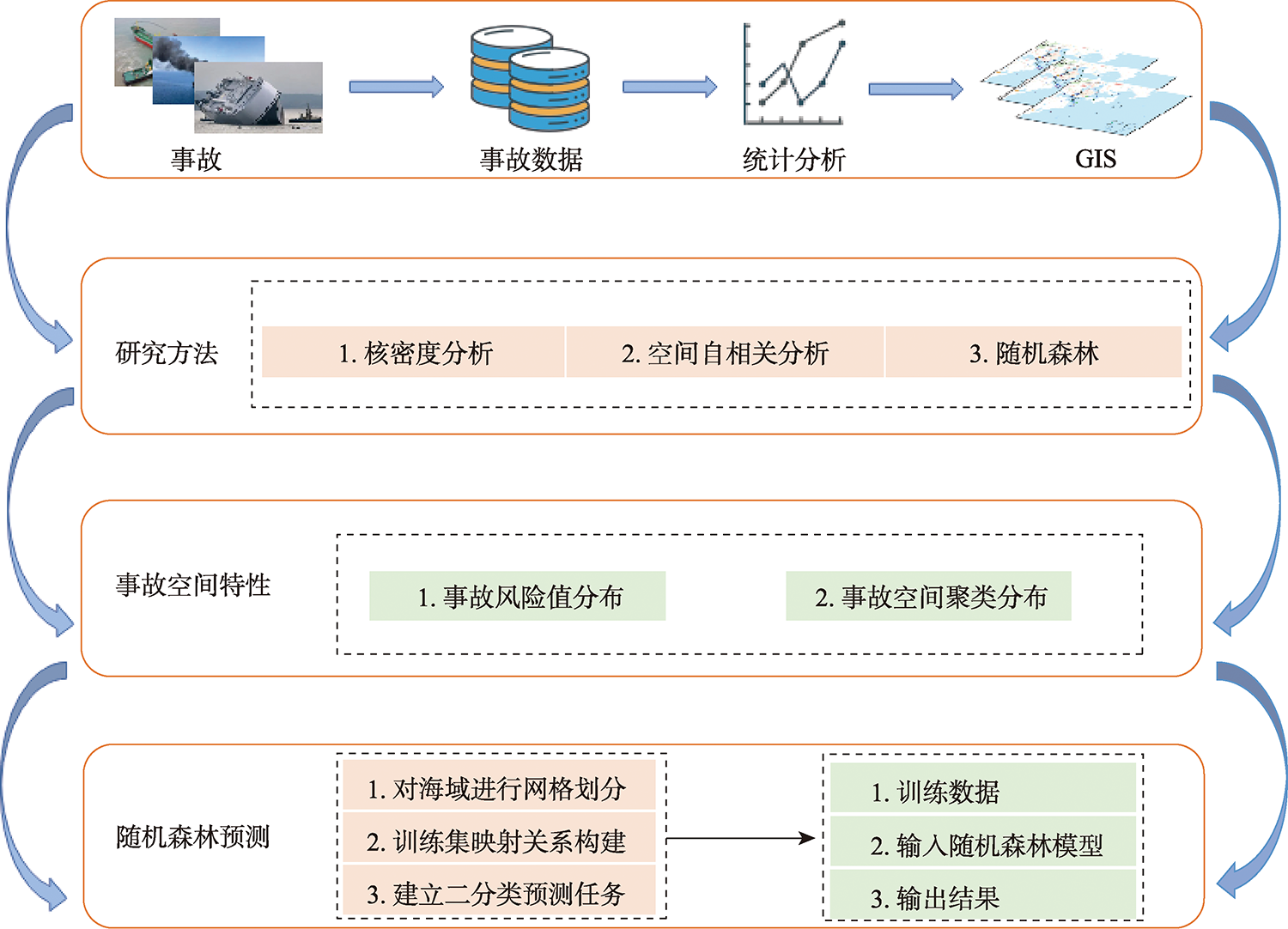
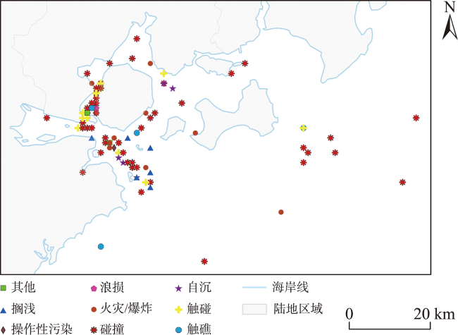
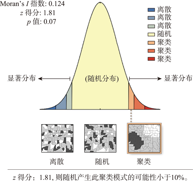
利用海上交通事故空间分布特征进行安全分析是海上交通安全管理的重要组成部分。本文使用厦门港2008—2020年的海上交通事故数据,经过事故数据空间分布特征提取、分析及预测等流程,最终得到厦门水域海上交通事故潜在危险区域。本文首先使用原始事故数据在GIS软件中进行空间定位,形成事故点的可视化空间分布图,然后使用核密度分析法鉴别海上交通事故多发区域,再利用空间自相关分析法,得到该区域事故空间的分布特征和具体的聚集点,最后使用该分布特征、对目标水域数据进行标准化网格切分,并利用机器学习算法对潜在事故风险区域进行预测。本文在核密度分析结果中发现:就事故频度而言,厦门湾和西海域交通事故频度较高。在空间自相关分析的结果中表明:就空间分布特征而言,厦门港的空间分布出现聚集特征且为空间正相关模式,且就事故具体的空间聚集点而言,厦门湾和西海域仍是事故高发的中心区域。而最后的厦门湾及周边水域风险预测模型显示:潜在事故风险区域多位于沿海和河口交汇区域。本文研究结果表明在基于地理空间数据分布特征提取和网格化分析的基础上,结合机器学习方法(随机森林),对于海上交通事故的预测具有良好的效果。
杨洋 , 邵哲平 , 赵强 , 潘家财 , 胡雨 , 梅强 . 基于厦门港的海上交通事故地理空间分布及风险预测研究[J]. 地球信息科学学报, 2022 , 24(9) : 1676 -1687 . DOI: 10.12082/dqxxkx.2022.210455
Safety analysis based on the spatial distribution of maritime traffic accidents is of great significance for maritime traffic safety management. In this paper, we obtained the potential risk areas of maritime traffic accidents in Xiamen waters through extraction, analysis, and prediction of spatial distribution of maritime traffic accident data in Xiamen Port from 2008 to 2020. The original accident data were firstly used for spatial orientation in GIS software to form a visualized spatial distribution map of accident points. Then, the areas where maritime traffic accidents frequently occur were identified using the kernel density analysis. In addition, the spatial autocorrelation analysis method was employed to obtain the spatial distribution characteristics and specific gathering points of accidents in this region. Finally, we performed standardized grid segmentation on the data in the target waters based on the spatial distribution characteristics and predicted potential risk areas of maritime traffic accidents using a machine learning algorithm (i.e., random forest). The kernel density analysis results showed that Xiamen Bay and Western Sea were high risk areas in terms of accident frequency. Moreover, the spatial autocorrelation analysis results indicated that in terms of spatial distribution characteristics, the spatial distribution of Xiamen Port showed aggregation characteristics and was positively correlated with time. For specific spatial gathering points of accidents, Xiamen Bay and Western Sea were still the centers with a high incidence of accidents. Furthermore, the risk prediction model of Xiamen Bay and its surrounding waters demonstrated that potential risk areas of maritime traffic accidents were mostly located at the intersection of coastal and estuary areas, because there were frequent crossings of vessels and fishing boats. The results of this study show that based on the distribution characteristics extracted and grid analysis of geospatial data, our proposed method has a good effect in predicting maritime traffic accidents by use of machine learning methods.
表1 事故严重等级分级及标准Tab. 1 Injury severity level of traffic crashes |
| 事故等级 | 人员伤亡 | 直接经济损失 | 水域环境污染 |
|---|---|---|---|
| 特别重大事故 | 30人以上死亡(含失踪),或者100人以上重伤 | 1亿元以上 | 溢油1000 t以上致污 |
| 重大事故 | 10~30人以下死亡(含失踪),或50~100人以下重伤 | 5000万元~1亿元以下 | 溢油500~1000 t致污 |
| 较大事故 | 3~10人以下死亡(含失踪),或10~50人以下重伤 | 1000万元~5000万元以下 | 溢油100~500 t致污 |
| 一般事故 | 1~3人以下死亡(含失踪),或1~10人以下重伤 | 100万元~1000万元以下 | 溢油1~100 t致污 |
| 小事故 | 指未达到一般事故等级 | ||
表2 z值、p值与置信度Tab. 2 z-value, p-value and confidence level |
| Z得分(标准差) | P值(概率) | 置信度/% |
|---|---|---|
| <-1.65或>+1.65 | <0.10 | 90 |
| <-1.95或>+1.95 | <0.05 | 95 |
| <-2.58或>+2.58 | <0.01 | 99 |
表3 全局莫兰汇总Tab. 3 Moran's I summary |
| Moran's I指数 | 预期指数 | 方差 | Z得分 | P值 |
|---|---|---|---|---|
| 0.1245 | -0.0101 | 0.0055 | 1.8108 | 0.0705 |
感谢上海海事大学胡勤友教授提供的AIS数据。
| [1] |
王焕新, 刘正江. 基于N-K模型的海上交通安全风险因素耦合分析[J]. 安全与环境学报, 2021, 21(1):56-61.
[
|
| [2] |
沈贤达, 张洁, 郭辰, 等. 基于风险分析的海上风机基础安全性评价研究[J]. 水利学报, 2015, 46(S1):326-330.
[
|
| [3] |
郑义彬, 杨慧慧, 倪荣. 基于系统动力学方法的江汉运河通航风险管理策略模拟及其效果分析[J]. 水运管理, 2021, 43(1):13-16,27.
[
|
| [4] |
张骞予, 杨家其. 基于ARERAC评价模型的水上交通安全风险源评估[J]. 水运管理, 2020, 42(7):35-40.
[
|
| [5] |
鲁峰, 李伟, 于仁海, 等. 可拓云评价模型在航道通航环境安全评价中的应用[J]. 天津航海, 2021(1):1-6.
[
|
| [6] |
虞盈, 兰培真. 基于灰色马尔科夫模型的福建辖区船舶交通事故预测[J]. 中国航海, 2017, 40(3):69-72.
[
|
| [7] |
汪强. 基于组合模型的海上交通事故预测研究[J]. 钦州学院学报, 2019, 34(5):10-14.
[
|
| [8] |
徐东星, 尹勇, 张秀凤, 等. 基于改进三参数灰色模型的海上交通事故预测[J]. 中国航海, 2020, 43(1):12-17.
[
|
| [9] |
王清斌, 王文亮, 赵睿. 基于改进XGBoost算法的船舶事故风险与类型预测[J/OL]. 安全与环境学报,1-9[2021-11-16].
[
|
| [10] |
|
| [11] |
|
| [12] |
|
| [13] |
|
| [14] |
|
| [15] |
|
| [16] |
|
| [17] |
|
| [18] |
|
| [19] |
|
| [20] |
|
| [21] |
阚小溪, 高悦尔, 杨春, 等. 路网形态对城市购物中心布局的影响—以福建厦门岛为例[J]. 地域研究与开发, 2021, 40(2):68-73.
[
|
| [22] |
陆化普, 罗圣西, 李瑞敏. 基于GIS分析的深圳市道路交通事故空间分布特征研究[J]. 中国公路学报, 2019, 32(8):156-164.
[
|
| [23] |
邢晓语, 杨秀春, 徐斌, 等. 基于随机森林算法的草原地上生物量遥感估算方法研究[J]. 地球信息科学学报, 2021, 23(7):1312-1324.
[
|
| [24] |
方秀琴, 郭晓萌, 袁玲, 等. 随机森林算法在全球干旱评估中的应用[J]. 地球信息科学学报, 2021, 23(6):1040-1049.
[
|
| [25] |
柳林, 刘文娟, 廖薇薇, 等. 基于随机森林和时空核密度方法的不同周期犯罪热点预测对比[J]. 地理科学进展, 2018, 37(6): 761-771.
[
|
| [26] |
中华人民共和国福建海事局.[EB/OL]. http://www.fj.msa.gov.cn/ 2021-08-04.
[ Fujian Maritime Safety Administration of People's Republic of China.[EB/OL]. http://www.fj.msa.gov.cn/ 2021-08-04. ]
|
| [27] |
水上交通事故统计办法[J]. 中华人民共和国国务院公报. 2015(1):44-47.
[Statistical Measure of Water Transport Accidents[J]. Gazette of the State Council of the People's Republic of China, 2015(1):44-47 ]
|
| [28] |
李佳, 古腾飞, 金磊, 等. 兴趣点定位的餐饮业空间特征分析方法[J]. 导航定位学报, 2021, 9(2):54-61.
[
|
| [29] |
蒋海兵, 李业锦. 京津冀地区制造业空间格局演化及其驱动因素[J]. 地理科学进展, 2021, 40(5):721-735.
[
|
| [30] |
上海海事大学.[ EB/OL]. https://www.shmtu.edu.cn/ 2021-08-04.
[Shanghai Maritime University.[EB/OL]. https://www.shmtu.edu.cn/ 2021-08-04. ]
|
| [31] |
|
/
| 〈 |
|
〉 |


