
向心扩张指数构建及其在郑州都市圈城镇空间扩张中的应用
|
刘天禹(1996— ),男,北京人,硕士生,主要从事土地资源与区域发展研究。E-mail: 201921051127@mail.bnu.edu.cn |
收稿日期: 2022-01-21
修回日期: 2022-03-11
网络出版日期: 2022-11-25
基金资助
科技基础资源调查专项(2019FY202502)
The Centripetal Expansion Index and Its Application in Urban Spatial Expansion in Zhengzhou Metropolitan Area
Received date: 2022-01-21
Revised date: 2022-03-11
Online published: 2022-11-25
Supported by
The Special Project of Science and Technology Basic Resources Survey(2019FY202502)
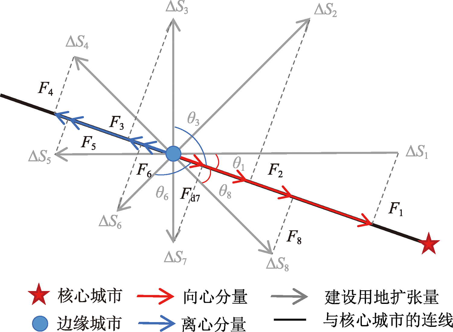
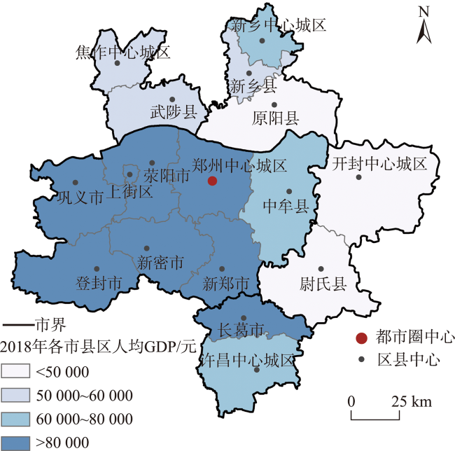
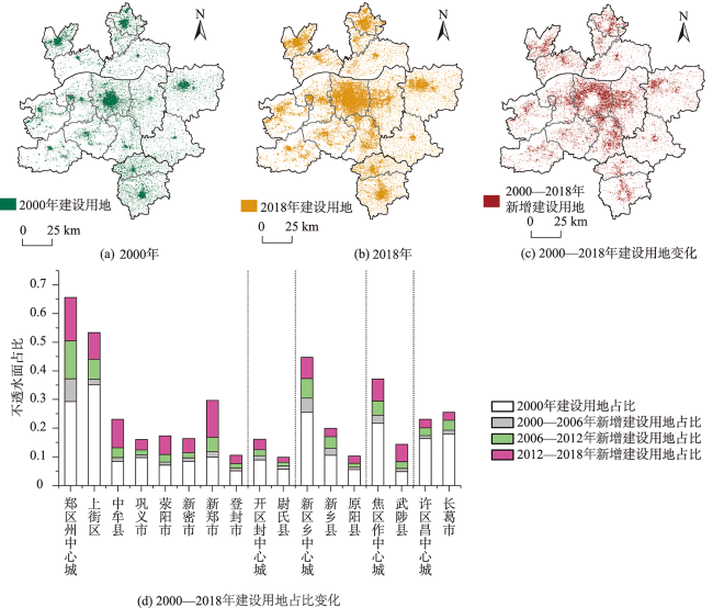
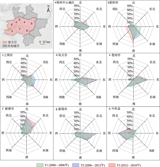
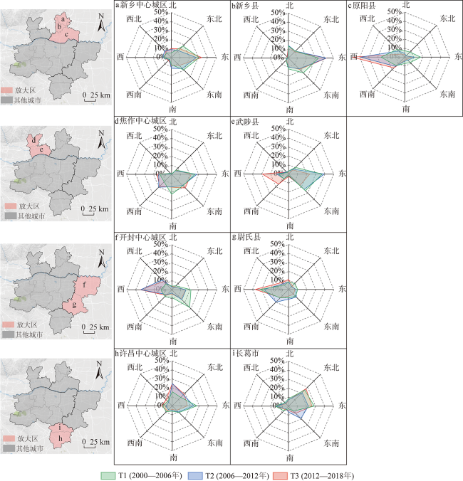
探究城镇空间扩张的方向性及其时间变化特征,能够反映都市圈发展过程中核心城市与边缘地区空间关联的动态过程,为制定都市圈发展的相关政策提供科学依据。本文从都市圈的核心城市与边缘地区相互关联的视角,借鉴物理学中力的分解原理,构建了同时兼顾扩张强度和方向性的向心扩张指数CEI,并以郑州都市圈为对象,采用2000—2018年30 m分辨率的全球人造不透水面数据产品GAIA,分析了建设用地扩张的总体数量和占比变化、动态度及强度变化、以及空间方向性变化等特征,进一步应用多元逻辑回归模型,揭示了影响城镇空间扩张向心性的关键因素。结果表明:① 向心扩张指数CEI为揭示都市圈核心城市对边缘地区的辐射带动作用提供方法支撑,能够定量刻画边缘地区朝向核心城市的发展趋势;② 在郑州都市圈近20年的快速扩张过程中,尽管各区县市的DEI指数和CEI指数随时间而增减波动,但郑州都市圈总体呈现“核心—边缘”发展模式,除个别地级市中心城区及其下辖县以外,多数区县市的向心性显著且随时间增强,郑州市中心城区对于边缘地区具有显著的辐射带动作用;③ 核心城市与边缘地区的人均GDP差异及城镇化率差异是影响边缘地区向心扩张的重要因素,与核心城市是否相邻、行政隶属关系及行政等级也对向心扩张具有一定影响。
刘天禹 , 陈晓琳 , 李强 , 陈晋 . 向心扩张指数构建及其在郑州都市圈城镇空间扩张中的应用[J]. 地球信息科学学报, 2022 , 24(9) : 1771 -1784 . DOI: 10.12082/dqxxkx.2022.220039
Exploring the urban spatial expansion and temporal change in metropolitan areas can reflect the dynamic spatial relationship between the core city and the peripheral areas. It can provide a scientific basis for formulating guidelines and policies for metropolitan areas. Considering the association between the core city and the peripheral areas in a metropolitan area, the paper constructs the Centripetal Expansion Index (CEI), which includes the expansion intensity and direction. Using the global artificial impervious layer data product (i.e., GAIA), this paper analyzes the expansion characteristics of urban development area of cities and towns in Zhengzhou metropolitan area from 2000 to 2018. And using the multiple logistic regression model, the paper further analyzes the factors that affect the centripetal expansion of cities and towns. The results show that: (1) The CEI provides a method support for revealing the effect of core city on the peripheral areas and measuring the expanding trend of the peripheral areas towards core city in metropolitan areas; (2) The Zhengzhou metropolitan area has experienced rapid spatial expansion in the past 20 years. Though the DEI index and CEI index of the peripheral areas fluctuate over time, Zhengzhou metropolitan area has a core-periphery development pattern. Most of the peripheral areas except the central urban areas of individual prefecture-level cities and their subordinate counties, are significantly centripetal and increase over time. The core city has a significant effect on the peripheral areas; (3) The differences in both per capita GDP and urbanization rate between core city and the peripheral areas are important factors influencing the centripetal expansion of the peripheral areas, while administrative affiliation, administrative rank, and proximity to core city also have influence on centripetal expansion.
表1 数据来源Tab. 1 Data Sources |
| 数据 | 来源 | 时间 |
|---|---|---|
| 建设用地 | 全球30 m分辨率人造不透水面逐年动态数据产品 (Global artificial impervious area,GAIA) http://data.ess.tsinghua.edu.cn/ | 2000—2018年 |
| 人均GDP | 《河南省统计年鉴》[27] | 2000—2018年 |
| 人口城镇化率 | 《河南省统计年鉴》[27] | 2000—2018年 |
表2 郑州都市圈2000—2018年建设用地扩张动态度及强度变化Tab. 2 Changes of urban land expansion dynamics and strength in Zhengzhou metropolitan area from 2000 to 2018 (%) |
| 城市 | 地区 | 动态度 | 强度 | ||||
|---|---|---|---|---|---|---|---|
| T1 | T2 | T3 | T1 | T2 | T3 | ||
| 郑州市 | 郑州中心城区 | 26.74 | 35.47 | 30.22 | 1.31 | 2.20 | 2.54 |
| 上街区 | 5.40 | 18.62 | 21.33 | 0.32 | 1.15 | 1.56 | |
| 中牟县 | 14.31 | 35.42 | 75.31 | 0.20 | 0.57 | 1.65 | |
| 巩义市 | 10.98 | 15.07 | 29.67 | 0.18 | 0.27 | 0.61 | |
| 荥阳市 | 15.55 | 33.02 | 59.55 | 0.18 | 0.45 | 1.08 | |
| 新密市 | 13.98 | 18.64 | 42.99 | 0.20 | 0.30 | 0.82 | |
| 新郑市 | 18.92 | 42.77 | 76.07 | 0.31 | 0.84 | 2.14 | |
| 登封市 | 21.06 | 24.53 | 38.82 | 0.18 | 0.25 | 0.49 | |
| 开封市 | 开封中心城区 | 15.73 | 20.21 | 29.71 | 0.23 | 0.35 | 0.62 |
| 尉氏县 | 20.33 | 18.10 | 21.95 | 0.19 | 0.21 | 0.30 | |
| 新乡市 | 新乡中心城区 | 19.08 | 22.61 | 19.58 | 0.81 | 1.15 | 1.22 |
| 新乡县 | 23.72 | 30.28 | 17.48 | 0.42 | 0.66 | 0.50 | |
| 原阳县 | 15.70 | 21.04 | 33.34 | 0.14 | 0.22 | 0.43 | |
| 焦作市 | 焦作中心城区 | 12.72 | 20.05 | 25.97 | 0.46 | 0.82 | 1.28 |
| 武陟县 | 22.16 | 39.43 | 74.05 | 0.18 | 0.39 | 1.02 | |
| 许昌市 | 许昌中心城区 | 6.27 | 15.74 | 14.72 | 0.17 | 0.46 | 0.49 |
| 长葛市 | 7.09 | 18.23 | 12.40 | 0.21 | 0.59 | 0.47 | |
| 郑州都市圈 | 16.39 | 25.76 | 35.39 | 0.30 | 0.55 | 0.95 | |
表3 模型变量及共线性检验Tab. 3 Model variables and collinearity test |
| 变量 | 表征值 | 数据来源 | VIF |
|---|---|---|---|
| Y:扩张趋势 | 离心、弱向心、强向心,类型 | CEI的计算结果 | - |
| X1:与核心城市人均GDP差异 | GDP差值,数值 | 统计年鉴 | 1.72 |
| X2:与核心城市人口城镇化率差异 | 人口城镇化率差值,数值 | 统计年鉴 | 2.00 |
| X3:与核心城市是否相邻 | 0=不相邻,1=相邻 | 行政区划图 | 1.56 |
| X4:行政级别是否为县级行政单元 | 0=非县级,1=县级 | 统计年鉴 | 2.29 |
| X5:行政管辖是否归属郑州市 | 0=非郑州下辖,1=郑州下辖 | 统计年鉴 | 2.49 |
表4 多元逻辑回归模型的结果Tab. 4 The result of multiple logistic regression model |
| 因变量 | 强向心 | 弱向心 | 强向心 |
|---|---|---|---|
| 参考类别 | 离心 | 离心 | 弱向心 |
| 解释变量 | 标准化系数β | ||
| 人均GDP差异 | 5.929*** | 0.972 | 4.957*** |
| 人口城镇化率差异 | 1.032 | 2.472** | -1.440 |
| 是否相邻 | 1.940*** | 0.161 | 1.779*** |
| 是否县级 | -1.293** | -0.058 | -1.235** |
| 是否郑州所辖 | 2.478*** | 1.369** | 1.109** |
注:***表示在0.01水平上显著,**表示在0.05水平上显著。 |
| [1] |
|
| [2] |
汪宇明. 核心-边缘理论在区域旅游规划中的运用[J]. 经济地理, 2002, 22(3):372-372.
[
|
| [3] |
中华人民共和国中央人民政府. 国家发展改革委关于培育发展现代化都市圈的指导意见[EB/OL]. 2019-02-21.
[ The Central People's Government of the People's Republic of China. Guiding opinions of the National Development and Reform Commission on cultivating and developing modern Metropolitan Areas[EB/OL]. 2019-02-21. ]
|
| [4] |
王亚飞, 樊杰. 中国主体功能区核心—边缘结构解析[J]. 地理学报, 2019, 74(4):710-722.
[
|
| [5] |
杜志威, 吕拉昌, 黄茹. 中国地级以上城市工业创新效率空间格局研究[J]. 地理科学, 2016, 36(3):321-327.
[
|
| [6] |
金凤君, 焦敬娟, 齐元静. 东亚高速铁路网络的发展演化与地理效应评价[J]. 地理学报, 2016, 71(4):576-590.
[
|
| [7] |
|
| [8] |
史春云, 张捷, 尤海梅, 等. 四川省旅游区域核心—边缘空间格局演变[J]. 地理学报, 2007, 62(6):631-639.
[
|
| [9] |
朱会义, 李秀彬. 关于区域土地利用变化指数模型方法的讨论[J]. 地理学报, 2003, 58(5):643-650.
[
|
| [10] |
王海军, 王惠霞, 邓羽, 等. 武汉城市圈城镇用地扩展的时空格局与规模等级模式分异研究[J]. 长江流域资源与环境, 2018, 27(2):272-285.
[
|
| [11] |
|
| [12] |
|
| [13] |
|
| [14] |
董廷旭, 秦其明, 王建华. 近30年来绵阳市城市用地扩展模式研究[J]. 地理研究, 2011, 30(4):667-675.
[
|
| [15] |
康红刚, 孙希华. 基于RS和GIS的城市扩展及驱动机制研究——以济南市为例[J]. 地域研究与开发, 2009, 28(3):135-139.
[
|
| [16] |
周一星, 许学强. 城市地理学[M]. 北京: 高等教育出版社, 2009.
[
|
| [17] |
赵东霞, 韩增林, 赵彪. 东北地区城市经济联系的空间格局及其演化[J]. 地理科学, 2016, 36(6):846-854.
[
|
| [18] |
刘帅宾, 杨山, 王钊. 基于人口流的中国省域城镇化空间关联特征及形成机制[J]. 地理学报, 2019, 74(4):648-663.
[
|
| [19] |
贺泽亚, 吴必虎, 刘瑜. 基于社交网络签到数据的城市空间相互作用和节点吸引力研究[J]. 北京大学学报(自然科学版), 2017, 53(5):862-872.
[
|
| [20] |
胡盈, 韩增林. 基于改进引力模型的辽中南城市群网络结构研究[J]. 地理与地理信息科学, 2019, 35(5):101-108.
[
|
| [21] |
|
| [22] |
|
| [23] |
李德仁, 罗晖, 邵振峰. 遥感技术在不透水层提取中的应用与展望[J]. 武汉大学学报·信息科学版, 2016, 41(5):569-577.
[
|
| [24] |
|
| [25] |
徐涵秋, 王美雅. 地表不透水面信息遥感的主要方法分析[J]. 遥感学报, 2016, 20(5):1270-1289.
[
|
| [26] |
中华人民共和国住房和城乡建设部. 住房城乡建设部办公厅关于国家标准《城乡用地分类与规划建设用地标准GB50137(修订)(征求意见稿)》公开征求意见的通知[EB/OL]. https://www.mohurd.gov.cn/gongkai/fdzdgknr/zqyj/201805/20180522_236162.html 2018-05-22.
[ Ministry of Housing and Urban-Rural Development of People’s Republic of China. Notice of the General Office of the Ministry of Housing and Urban-Rural development on public comments on the national standard "Urban and rural land classification and planning and construction land standard GB50137 (Revised) (Draft for Comment)"[EB/OL]. https://www.mohurd.gov.cn/gongkai/fdzdgknr/zqyj/201805/20180522_236162.html 2018-05-22. ]
|
| [27] |
河南省统计局. 河南统计年鉴[M]. 北京: 中国统计出版社, 2019.
[ Henan Province Bureau of Statistics. Henan statistical yearbook[M]. Beijing: China Statistics Press, 2019. ]
|
| [28] |
|
| [29] |
|
| [30] |
|
| [31] |
冯珊珊, 樊风雷. Landsat/OLI与夜间灯光数据在提取城市不透水面中的精度差异分析[J]. 地球信息科学学报, 2019, 21(10):1608-1618.
[
|
| [32] |
|
| [33] |
|
| [34] |
河南省发展和改革委员会. 郑州大都市区包含哪些城市?[EB/OL]. http://fgw.henan.gov.cn/2019/02-22/735304.html 2019-01-17.
[ Henan Provincial Development and
|
| [35] |
中华人民共和国中央人民政府. 国务院关于支持河南省加快建设中原经济区的指导意见[EB/OL]. http://www.gov.cn/gongbao/content/2011/content_1967415.htm 2011-09-28.
[ The Central People's Government of the People's Republic of China. Guiding opinions of the state council on supporting Henan Province to accelerate the construction of the central plains economic zone[EB/OL]. http://www.gov.cn/gongbao/content/2011/content_1967415.htm 2011-09-28. ]
|
| [36] |
赵可, 张安录, 李平. 城市建设用地扩张的驱动力——基于省际面板数据的分析[J]. 自然资源学报, 2011, 26(8):1323-1332.
[
|
| [37] |
朴妍, 马克明. 北京城市建成区扩张的经济驱动:1978-2002[J]. 中国国土资源经济, 2006, 7:34-37.
[
|
| [38] |
刘瑞, 杨文治, 朱道林, 等. 基于Logistic回归模型的德州市城市建设用地扩张驱动力分析[J]. 资源科学, 2009, 31(11):1919-1926.
[
|
| [39] |
王雅竹, 段学军, 杨清可, 等. 近30年江苏省建设用地扩张的时空特征、模式与驱动因素研究[J]. 长江流域资源与环境, 2019, 28(7):1531-1540.
[
|
| [40] |
吝涛, 李新虎, 张国钦, 等. 厦门岛城市空间扩张特征及其影响因素分析[J]. 地理学报, 2010, 65(6):715-726.
[
|
| [41] |
喻菁, 焦利民, 董婷. 结合宏观和微观视角的城市扩张方向异质性分析[J]. 地理与地理信息科学, 2019(2):90-96.
[
|
| [42] |
王成龙, 刘慧, 张梦天. 行政边界对城市群城市用地空间扩张的影响——基于京津冀城市群的实证研究[J]. 地理研究, 2016, 35(1):173-183.
[
|
| [43] |
范立新. 回归分析中多重共线性诊断方法[J]. 国外医学:卫生学分册, 1994, 1:34-37.
[
|
/
| 〈 |
|
〉 |
