
结合ICESat-2和GEDI的中国东南丘陵地区ASTER GDEM高程精度评价与修正
|
焦怀瑾(1999— ),男,江西吉安人,硕士研究生,主要从事地学可视化与虚拟地理环境研究。E-mail: huai_jin@foxmail.com |
收稿日期: 2022-07-06
修回日期: 2022-10-16
网络出版日期: 2023-04-19
基金资助
福建省科技计划项目(2020I0008)
福建省高校产学合作项目(2022N5008)
福建省科技创新领军人才项目
Elevation Accuracy Evaluation and Correction of ASTER GDEM in China Southeast Hilly Region by Combining ICESat-2 and GEDI data
Received date: 2022-07-06
Revised date: 2022-10-16
Online published: 2023-04-19
Supported by
Fujian Provincial Science and Technology Plan Project(2020I0008)
Fujian Provincial Univer- sity-industry Cooperation Project(2022N5008)
Fujian Provincial Leading Talents of Scientific and Technological Innovation Project
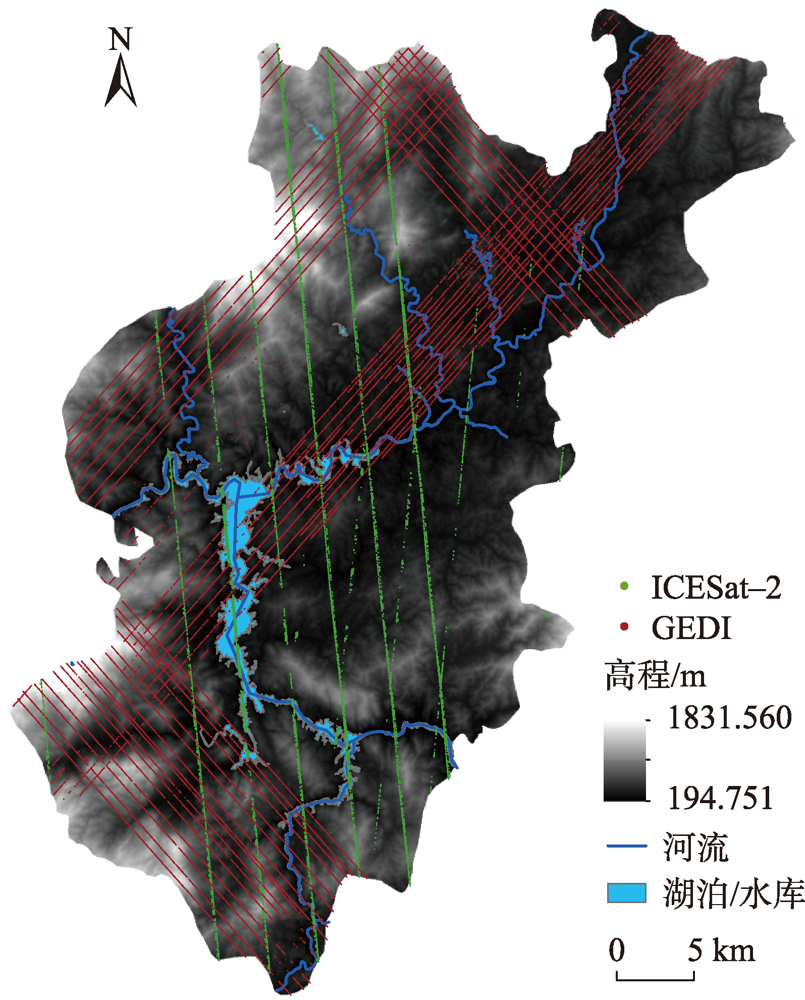
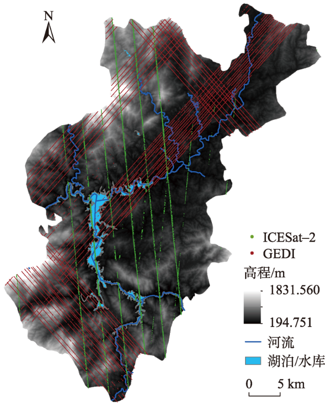
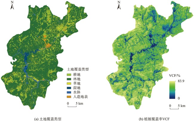
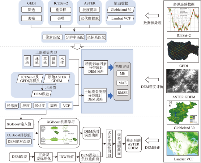
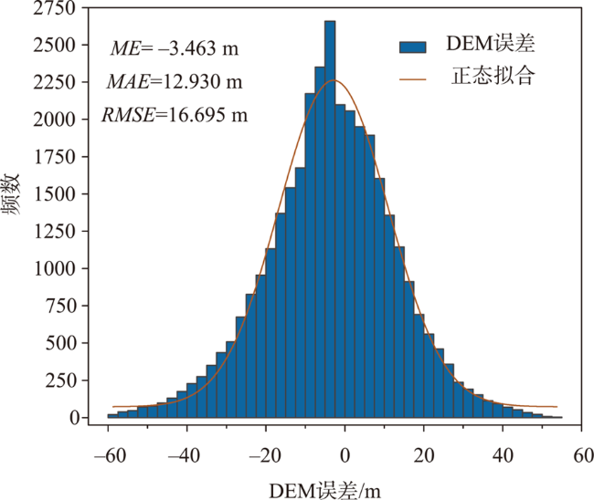
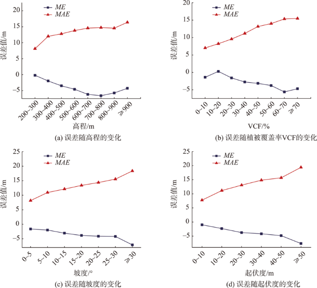
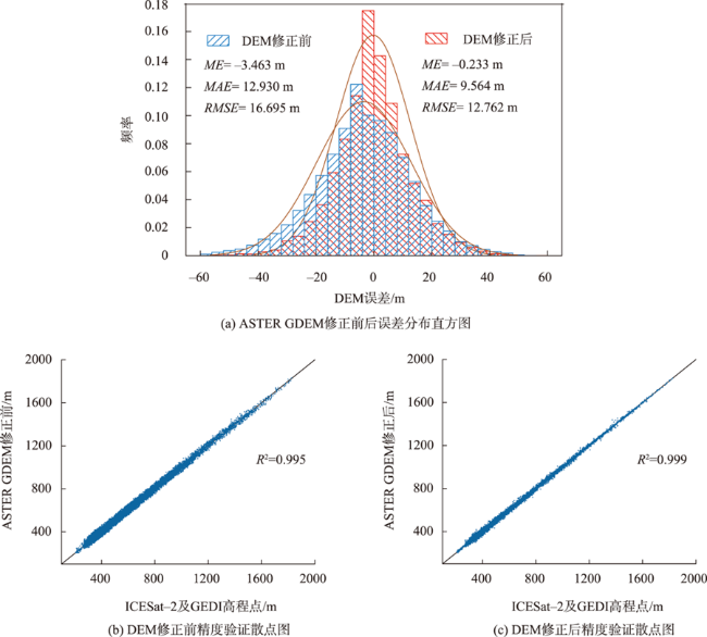
星载激光雷达ICESat-2和GEDI可以为数字高程模型产品的精度评价与修正提供全球覆盖的、可靠的高精度参考数据源。然而,现有的DEM修正方法主要是针对DEM误差中的植被高信号且多采用线性回归模型。为此,本文分析了ASTER GDEM v3精度与土地覆盖类型、高程、坡度、起伏度及植被覆盖率的关系。在此基础上,提出了一种考虑上述多种精度影响因素并结合XGBoost和空间插值的DEM误差修正方法。结果分析表明:原始ASTER GDEM的误差整体呈正态分布,平均误差为-3.463 m,存在较大负偏差,高程精度随着高程、坡度、起伏度及植被覆盖率VCF的增大呈降低趋势;经过修正后, ASTER GDEM平均误差降低到了-0.233 m,负偏差得到有效改善,整体平均绝对误差降低了26.04%,整体均方差降低了23.56%,耕地、林地、草地、湿地、水域及人造地表的DEM平均绝对误差和均方差都有不同程度的降低;本文提出的方法对多种特征要素与地形误差间的非线性关系进行拟合建模,在研究区取得了较好的修正效果。
焦怀瑾 , 陈崇成 , 黄洪宇 . 结合ICESat-2和GEDI的中国东南丘陵地区ASTER GDEM高程精度评价与修正[J]. 地球信息科学学报, 2023 , 25(2) : 409 -420 . DOI: 10.12082/dqxxkx.2023.220483
Global Ecosystem Dynamics Investigation (GEDI) and Ice, Cloud, and land Elevation Satellite-2 (ICESat-2) products provide reliable global references for the accuracy evaluation and correction of Global Digital Elevation Model (GDEM). However, existing DEM correction methods mainly address the signal of vegetation in DEM errors and mostly use linear regression models. So, we first analyze the relationship between Advanced Spaceborne Thermal Emission and Reflection Radiometer (ASTER) GDEM v3 data accuracy and the land cover type, elevation, slope, relief amplitude, and vegetation coverage. Based on this, this paper proposes a Digital Elevation Model (DEM) error correction method that takes into account various influencing factors and combines Extreme Gradient Boosting (XGBoost) machine learning and spatial interpolation to model the errors. The analysis of the results shows that the overall error of the original ASTER GDEM has a normal distribution with a large negative offset (average error of -3.463 m). The Mean Absolute Error (MAE) and Root Mean Squared Error (RMSE) of original ASTER GDEM are 12.930 m and 16.695 m, respectively, and the elevation accuracy decreases with the increase of elevation, slope, relief amplitude, and vegetation coverage. After correction, the Mean Error (ME) of ASTER GDEM is reduced to -0.233 m, which means the negative deviation is effectively removed and the overall MAE and overall RMSE are reduced by 26.04% and 23.56%, respectively. The MAE and RMSE of DEM for cultivated lands, forests, grasslands, wetlands, water bodies, and man-made surfaces are all reduced by different degrees. The DEM accuracy evaluation and correction method proposed in this paper models the non-linear relationships between multiple feature elements and terrain errors and achieves better correction results in the study area.
表1 DEM误差及DEM绝对误差与各影响因素的Spearman相关系数Tab. 1 Spearman correlation coefficients of DEM error and absolute DEM error with each influencing factor |
| 经度 | 纬度 | 高程 | 坡度 | 起伏度 | VCF | |
|---|---|---|---|---|---|---|
| DEM误差 | 0.070 | 0.055 | -0.106 | -0.080 | -0.089 | -0.098 |
| DEM绝对误差 | -0.059 | -0.013 | 0.170 | 0.212 | 0.228 | 0.210 |
表2 不同土地覆盖类型下的ASTER GDEM误差Tab. 2 Error of ASTER GDEM for different land cover types |
| 土地覆盖类型 | ME/m | MAE/m | RMSE/m |
|---|---|---|---|
| 耕地 | -0.435 | 9.748 | 12.820 |
| 林地 | -4.344 | 14.077 | 17.866 |
| 草地 | -2.464 | 12.837 | 16.510 |
| 湿地 | -4.232 | 6.275 | 7.728 |
| 水域 | -3.560 | 8.095 | 11.023 |
| 人造地表 | 0.738 | 8.445 | 10.973 |
表4 不同土地覆盖类型下的DEM数据在修正前后的精度Tab. 4 Accuracy of DEM data under different land cover types before and after correction |
| 土地覆盖类型 | ME/m | MAE/m | RMSE/m | |||||
|---|---|---|---|---|---|---|---|---|
| 修正前 | 修正后 | 修正前 | 修正后 | 修正前 | 修正后 | |||
| 耕地 | -0.435 | -0.333 | 9.748 | 6.827 | 12.820 | 9.320 | ||
| 林地 | -4.344 | -0.349 | 14.077 | 10.597 | 17.866 | 13.712 | ||
| 草地 | -2.464 | 0.956 | 12.837 | 10.167 | 16.510 | 13.590 | ||
| 湿地 | -4.232 | -1.147 | 6.275 | 2.634 | 7.728 | 4.331 | ||
| 水域 | -3.560 | -0.223 | 8.095 | 3.043 | 11.023 | 5.179 | ||
| 人造地表 | 0.738 | -0.124 | 8.445 | 5.778 | 10.973 | 7.636 | ||
| [1] |
汤国安, 那嘉明, 程维明. 我国区域地貌数字地形分析研究进展[J]. 测绘学报, 2017, 46(10):1570-1591.
[
|
| [2] |
|
| [3] |
张海平, 汤国安, 熊礼阳, 等. 面向地貌学本源的DEM增值理论框架与构建方法[J]. 地理学报, 2022, 77(3):518-533.
[
|
| [4] |
|
| [5] |
|
| [6] |
|
| [7] |
|
| [8] |
郑迎辉, 张艳, 王涛, 等. 基于ICESat-2数据的高程控制点提取和精度验证[J]. 地球信息科学学报, 2022, 24(7):1234-1244.
[
|
| [9] |
|
| [10] |
|
| [11] |
|
| [12] |
|
| [13] |
|
| [14] |
|
| [15] |
张晨, 朱建军, 付海强. 基于ICESat-2数据及TanDEM-X DEM的林下地形反演[J]. 测绘工程, 2021, 30(1):60-65.
[
|
| [16] |
杜小平, 郭华东, 范湘涛, 等. 基于ICESat/GLAS数据的中国典型区域SRTM与ASTER GDEM高程精度评价[J]. 地球科学, 2013, 38(4):887-897.
[
|
| [17] |
|
| [18] |
秦臣臣, 陈传法, 杨娜, 等. 基于ICESat/GLAS的山东省SRTM与ASTER GDEM高程精度评价与修正[J]. 地球信息科学学报, 2020, 22(3):351-360.
[
|
| [19] |
|
| [20] |
唐新明, 李世金, 李涛, 等. 全球数字高程产品概述[J]. 遥感学报, 2021, 25(1):167-181.
[
|
| [21] |
|
| [22] |
朱笑笑, 王成, 习晓环, 等. ICESat-2星载光子计数激光雷达数据处理与应用研究进展[J]. 红外与激光工程, 2020, 49(11):76-85.
|
| [23] |
|
| [24] |
|
| [25] |
|
| [26] |
林晓娟. 基于ICESat-2和GEDI森林冠层高度和森林地上生物量遥感诊断[D]. 北京: 中国科学院大学(中国科学院空天信息创新研究院), 2021.
[
|
| [27] |
|
| [28] |
|
| [29] |
|
| [30] |
|
| [31] |
|
| [32] |
|
/
| 〈 |
|
〉 |
