
SAR卫星影像洪水检测研究进展及展望
|
高寒新(1997—),女,山东淄博人,硕士生,主要从事SAR影像洪水检测方面的研究。E-mail: ghx@mail.bnu.edu.cn |
收稿日期: 2023-02-12
修回日期: 2023-05-07
网络出版日期: 2023-09-22
基金资助
国家重点研发计划专项(2021YFB3901203)
Research Progress and Prospect of Flood Detection Based on SAR Satellite Images
Received date: 2023-02-12
Revised date: 2023-05-07
Online published: 2023-09-22
Supported by
National Key Research and Development Project(2021YFB3901203)
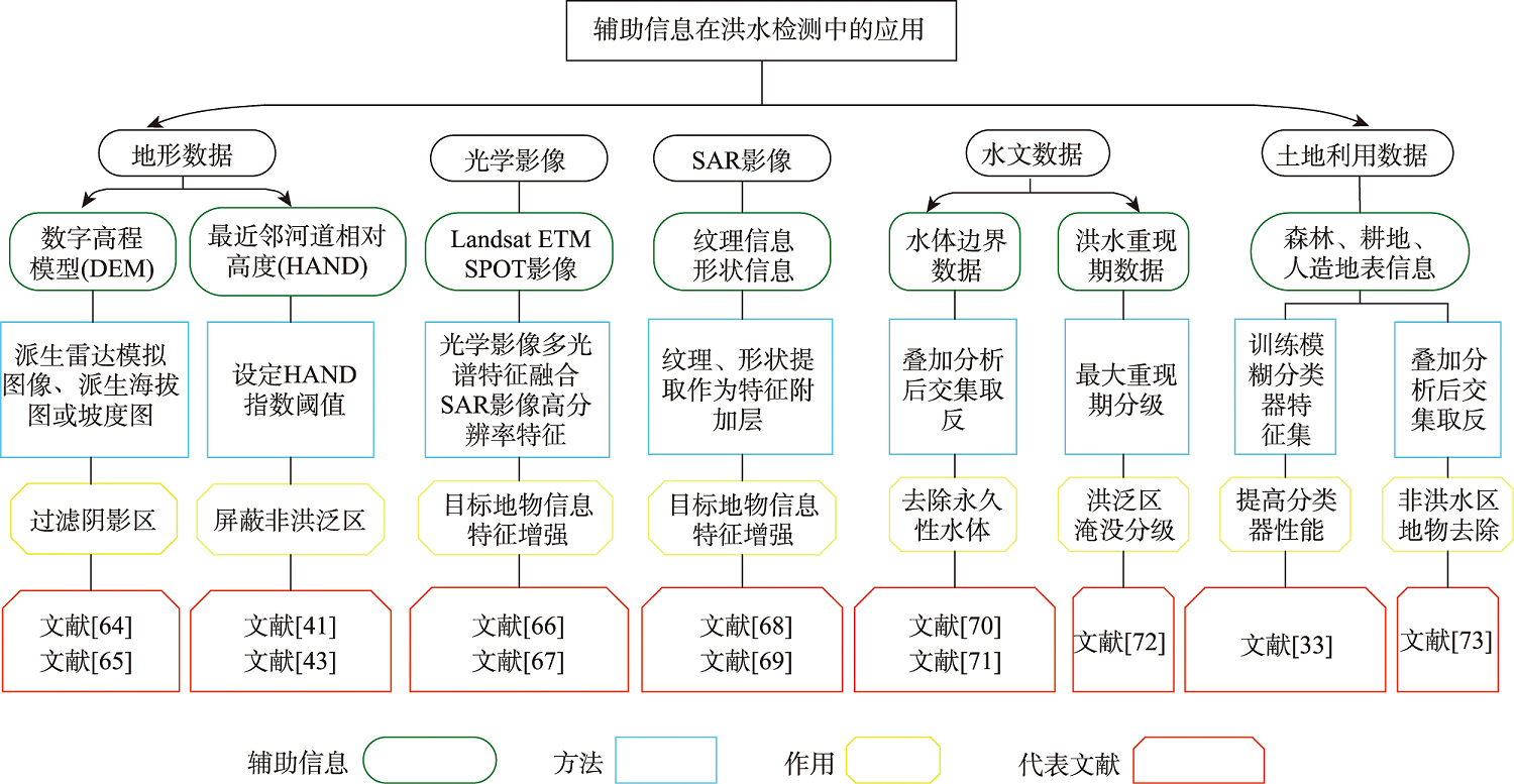
雷达卫星能够穿透云雾,全天时、全天候获取洪涝灾害期间地面的水体信息,被广泛应用于洪水检测。本文从合成孔径雷达(SAR)卫星数据源、洪水检测方法、辅助信息在洪水检测中的应用、精度评价、SAR洪水检测的挑战与发展方向六个方面,总结分析了国内外SAR影像洪水检测领域的研究进展。首先重点梳理了基于阈值分割、分类器和变化检测等洪水检测方法,发现阈值法计算速度快、应用广泛,分类器法可以充分发挥主观性和客观性,变化检测法可有效限制过度检测与影像几何误差。接着分析了光学遥感影像、地形、纹理、水文、土地覆盖/利用等辅助信息在洪水检测中的应用,发现SAR影像结合辅助数据进行洪水检测成为研究热点。然后综合洪水遥感检测的应用需求和SAR水体信息提取技术发展历程,分析了洪水检测在影像数据源、预处理、检测算法及精度验证等方面面临的挑战及原因,总结出目前SAR洪水检测的发展方向:即SAR洪水检测辅助信息的广泛应用、同一SAR影像洪水的差异化识别和基于SAR影像的洪水概率制图等。
高寒新 , 陈波 , 孙洪泉 , 田玉刚 . SAR卫星影像洪水检测研究进展及展望[J]. 地球信息科学学报, 2023 , 25(10) : 1933 -1953 . DOI: 10.12082/dqxxkx.2023.230060
Being able to penetrate clouds and fog, Synthetic Aperture Radar (SAR) imagery has been widely used in flood mapping and flood detection regardless of time and weather condition. Improving the accuracy of flood maps retrieved from SAR images is of both scientific and practical significance. However, errors in SAR-derived flood maps can come from SAR image measuring principles, image acquisition and pre-processing system, water detection algorithms, and the remarkable temporal dynamics of the flooding process. The aim of this paper is to provide an extensive literature review of flood detection using SAR images (about 108 peer reviewed journal papers), including SAR data sources, flood detection methods, application of auxiliary information, accuracy evaluation, and challenges and opportunities for future research. Based on the articles reporting flood detection methods, it is found that the threshold segmentation methods such as the OTSU and KI algorithms are computationally fast and have been most widely used. The classification methods (e.g., the support vector machine and K-means clustering algorithms) have the flexibility to account for both subjectivity and objectivity, and the change detection method using the difference and ratio algorithms can effectively suppress over-detection and image geometric errors. Additionally, combining SAR images with four major types of auxiliary data to increase flood detection accuracy has become a hot topic in the past decades. Specifically, terrain information such as Digital Elevation Model (DEM), Height Above Nearest Drainage (HAND), and topographic slope can effectively reduce the impacts of shadows and exclude non-flooded areas. SAR image textural and multispectral optical information (e.g., Landsat data and aerial photos) can enhance the recognition ability of water features. Land cover/use data facilitate removing non-water features that are similar to water features, and hydrological data can help excluding permanent water bodies from temporary flood areas. From the perspectives of SAR image types, image preprocessing, detection algorithms, and accuracy assessment, major challenges are further discussed including insufficient understanding of the complexity of SAR backscattering information, limited progress in improving the signal-to-noise ratio during image pre-processing, lack of versatile flood detection algorithms, and low availability of high-quality verification data. While opportunities for future SAR-based flood detection research include combination of auxiliary information in detection algorithms, use of multiple rather than single threshold for water detection, and transition from deterministic toward probabilistic flood mapping.
表1 洪水检测可利用的SAR卫星数据信息Tab. 1 Available SAR satellite data information for flood detection |
| 工作波段 | SAR数据 | 扫描宽度/km | 分辨率/m | 重复周期/d | 国家/机构 | 工作年限/年 |
|---|---|---|---|---|---|---|
| L | ALOS-PALSAR1 | 40~350 | 7~14~100 | 46 | 日本 | 2006—2011 |
| ALOS-PALSAR2 | 25/35/60/70/350 | 1/3/6/10/100 | 14 | 日本 | 2006—2011 | |
| C | ERS-1 | 100 | 30 | 35 | 欧空局 | 1991—2000 |
| ERS-2 | 100 | 30 | 35 | 欧空局 | 1995—2010 | |
| ENVISAT-ASAR | 100~400 | 20/70/150 | 35 | 欧空局 | 2002—2012 | |
| RADARSAT-1 | 45~500 | 8~100 | 24 | 加拿大 | 1995—2013 | |
| RADARSAT-2 | 15~500 | 3~100 | 24 | 加拿大 | 2007—至今 | |
| Sentinel-1 | 20/80/250/400 | 5/20/40 | 12 | 欧空局 | 2014—至今 | |
| GF3 | 10~650 | 1~500 | <3 | 中国 | 2016—至今 | |
| HISEA-1 | 5~100 | 1 | 3 | 中国 | 2020—至今 | |
| X | TerraSAR-X | 5~10~30~100 | 1~3~16 | 11 | 德国 | 2007—至今 |
| COSMO-SkyMed | 10~30~200 | 1~3~15 | 16 | 意大利 | 2007—至今 | |
| Ku | Qilu-1 | 500 | 0.5 | - | 中国 | 2021—至今 |
表2 SAR洪水检测方法分类及其特征、优缺点、例子与关键文献Tab. 2 Classification of SAR flood detection methods and their characteristics, advantages and disadvantages, examples and key references |
| 方法 | 特征 | 优点 | 缺点 | 例子 | 关键文献 | |
|---|---|---|---|---|---|---|
| 阈值法 | 参数化 | 事先对地物类别统计分布做假设,计算统计模型参数 | 方法简单,计算效率高 | 过度依赖直方图的双峰分布性,受环境异质性影响大 | 单峰分布拟合(伽马),多峰分布拟合(高斯) | 文献[18]、文献[19]、 文献[20]、文献[21] |
| 非参数化 | 不作先验分布假设 | 大津算法(OTSU),水体指数提取法 | 文献[15⇓⇓⇓⇓⇓⇓]、文献[22]、 文献[23]、文献[24] | |||
| 分类器法 | 监督分类 | 需地物相应像素组成的训练集 | 不需在设计算法前深入了解影像地物的散射特性,控制训练样本的选择 | 训练集的生成很难自动化,水体内部的方差值越大,样本代表性越差 | 随机森林分类器,支撑向量机 | 文献[25]、文献[26]、 |
| 非监督分类 | 不施加任何的先验知识,算法自学习并进行聚类 | 不需先验知识,人为误差机会减小 | “同物异谱”及“异物同谱”现象使分类集群与地类间不对应 | ISODATA,K-means聚类 | 文献[27]、文献[28]、 文献[29] | |
| 半监督分类 | 已分类与未分类数据一起参与分类器训练 | 弥补监督学习样本泛化性不足,提高非监督学习模型精度 | 训练模型过程较复杂,时间成本较大 | 卷积神经网络(CNN)快速洪水范围制图法 | 文献[30]、文献[31]、 | |
| 面向对象 | 基于包含重要语义信息在内的对象及其间的相互关系训练分类器 | 充分利用除辐射信息外的对象信息(例形状),有效解决影像的椒盐噪声问题 | 模型较复杂,地物分割尺寸影响分类精度 | 形态语义分割 | 文献[32]、文献[33]、 | |
| 变化检测 | 需洪水前(非淹没)影像,多与阈值分割技术配合使用 | 有效限制过度检测与影像几何误差 | 受影像条件限制大,受斑点噪音影响大 | 比值影像,差值影像 | 文献[18]、文献[19]、 | |
| 干涉测量 | 根据相干性值的高低区分淹没与非淹没区 | 限制建筑物的双重反射效应对洪水识别的干扰 | 相干性对时间基线非常敏感,强度信息与相位信息同时计算复杂 | CSK强度图与相干图RGB通道组合 | 文献[34]、文献[35]、 | |
| 时间序列 | 基于时间序列数据获取动态淹没图 | 减弱洪水信息与物候周期有关的植被地物的混淆 | 数据采样频率不高、存储空间要求高 | NDFI和NDFVI的阈值法 | 文献[36]、文献[37]、 | |
| [1] |
|
| [2] |
陈玲艳, 刘智, 张红. 基于水体散射特性的SAR图像水体检测[J]. 遥感技术与应用, 2014, 29(6):963-969.
[
|
| [3] |
徐涵秋. 利用改进的归一化差异水体指数(MNDWI)提取水体信息的研究[J]. 遥感学报, 2005, 9(5):589-595.
[
|
| [4] |
都金康, 黄永胜, 冯学智, 等. SPOT卫星影像的水体提取方法及分类研究[J]. 遥感学报, 2001, 5(3):214-219.
[
|
| [5] |
杨存建, 魏一鸣, 陈德清. 基于星载雷达的洪水灾害淹没范围获取方法探讨[J]. 自然灾害学报, 1998, 7(3):45-50.
[
|
| [6] |
张薇, 杨思全, 王磊, 等. 合成孔径雷达数据减灾应用潜力研究综述[J]. 遥感技术与应用, 2012, 27(6):904-911.
[
|
| [7] |
|
| [8] |
|
| [9] |
|
| [10] |
|
| [11] |
陈赛楠, 蒋弥. Sentinel-1 SAR在洪水范围提取与极化分析中的应用研究[J]. 地球信息科学学报, 2021, 23(6):1063-1070.
[
|
| [12] |
郭欣, 赵银娣. 基于Sentinel-1A SAR的湖南省宁乡市洪水淹没监测[J]. 遥感技术与应用, 2018, 33(4):646-656.
[
|
| [13] |
李胜阳, 许志辉, 陈子琪, 等. 高分3号卫星影像在黄河洪水监测中的应用[J]. 水利信息化, 2017, 140(5):22-26,72.
[
|
| [14] |
|
| [15] |
|
| [16] |
|
| [17] |
|
| [18] |
|
| [19] |
|
| [20] |
|
| [21] |
|
| [22] |
|
| [23] |
贾诗超, 薛东剑, 李成绕, 等. 基于Sentinel-1数据的水体信息提取方法研究[J]. 人民长江, 2019, 50(2):213-217.
[
|
| [24] |
|
| [25] |
|
| [26] |
|
| [27] |
孟令奎, 毛旭东, 魏祖帅, 等. 结合先验概率估计的GF-3 影像水体概率估计方法[J]. 测绘学报, 2019, 48(4):439-447.
[
|
| [28] |
|
| [29] |
王磊, 连增增. 基于Sentinel-1A的2020年鄱阳湖流域洪水灾害遥感监测[J]. 地理空间信息, 2022, 20(6):43-46.
[
|
| [30] |
|
| [31] |
韩宇韬, 吕琪菲, 周保琢, 等. 基于协同训练半监督学习的遥感影像水体提取方法及系统: CN105279519B[P].2018-09-21.
[
|
| [32] |
汤玲英, 刘雯, 杨东, 等. 基于面向对象方法的Sentinel-1A SAR在洪水监测中的应用[J]. 地球信息科学学报, 2018, 20(3):377-384.
[
|
| [33] |
|
| [34] |
|
| [35] |
|
| [36] |
|
| [37] |
|
| [38] |
|
| [39] |
|
| [40] |
|
| [41] |
|
| [42] |
|
| [43] |
|
| [44] |
|
| [45] |
|
| [46] |
|
| [47] |
|
| [48] |
何海清, 杜敬, 陈婷, 等. 结合水体指数与卷积神经网络的遥感水体提取[J]. 遥感信息, 2017, 32(5):82-86.
[
|
| [49] |
|
| [50] |
|
| [51] |
徐庆伶. 基于半监督学习的遥感图像分类研究[D]. 西安: 陕西师范大学, 2011.
[
|
| [52] |
彭海涛, 柯长青. 基于多层分割的面向对象遥感影像分类方法研究[J]. 遥感技术与应用, 2010, 25(1):149-154.
[
|
| [53] |
殷亚秋, 李家国, 余涛, 等. 基于高分辨率遥感影像的面向对象水体提取方法研究[J]. 测绘通报, 2015(1):81-85.
[
|
| [54] |
|
| [55] |
|
| [56] |
|
| [57] |
|
| [58] |
|
| [59] |
|
| [60] |
|
| [61] |
|
| [62] |
高伟, 沈秋, 李梦璠, 等. 基于多源遥感数据的洪涝淹没范围时序监测分析[J]. 测绘与空间地理信息, 2018, 41(7):8-10,14.
[
|
| [63] |
|
| [64] |
杨存建, 魏一鸣, 王思远, 等. 基于DEM的SAR图像洪水水体的提取[J]. 自然灾害学报, 2002, 11(3):121-125.
[
|
| [65] |
|
| [66] |
王志豪, 李刚, 蒋骁. 基于光学和SAR遥感图像融合的洪灾区域检测方法[J]. 雷达学报, 2020, 9(3):539-553.
[
|
| [67] |
|
| [68] |
邓滢, 张红, 王超, 等. 结合纹理与极化分解的面向对象极化SAR水体提取方法[J]. 遥感技术与应用, 2016, 31(4):714-723.
[
|
| [69] |
|
| [70] |
|
| [71] |
|
| [72] |
|
| [73] |
|
| [74] |
|
| [75] |
|
| [76] |
|
| [77] |
|
| [78] |
林婷婷, 史培军, 马春英, 等. 最近邻河道相对高度及其在中国洪水淹没制图中的应用[J]. 北京师范大学学报(自然科学版), 2022, 58(2):300-309.
[
|
| [79] |
|
| [80] |
|
| [81] |
王乐, 牛雪峰, 王明常. 遥感影像融合技术方法研究[J]. 测绘通报, 2011(1):6-8.
[
|
| [82] |
雷俊杰, 杨武年, 李红, 等. 哨兵光学及SAR卫星影像协同分类研究[J]. 现代电子技术, 2022, 45(2):135-139.
[
|
| [83] |
|
| [84] |
|
| [85] |
王龙. 图像纹理特征提取及分类研究[D]. 青岛: 中国海洋大学, 2014.
[
|
| [86] |
|
| [87] |
|
| [88] |
|
| [89] |
|
| [90] |
|
| [91] |
|
| [92] |
|
| [93] |
|
| [94] |
|
| [95] |
|
| [96] |
杨雨晴, 王冬梅, 徐佳. 基于局部自适应阈值的GF-3 SAR影像洪涝水体提取[J]. 地理空间信息, 2021, 19(6):54-59,5.
[
|
| [97] |
|
| [98] |
|
| [99] |
李玉, 王姝运, 赵泉华. 基于斑点统计特性保持的SAR影像迭代滤波[J]. 电子学报, 2021, 49(9):1809-1817.
[
|
| [100] |
|
| [101] |
|
| [102] |
|
| [103] |
|
| [104] |
|
| [105] |
|
| [106] |
|
| [107] |
|
| [108] |
|
/
| 〈 |
|
〉 |