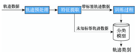
Spatial-temporal trajectory classification aims at predicting the category of a spatial-temporal trajectory. The classification of spatial-temporal trajectories plays an important role in urban planning, personalized user recommendation and so on. The process of trajectory classification includes three stages: trajectory preprocessing, feature extraction and classification. This paper reviews the recent research progress on trajectory classification. Firstly, we introduce the process of trajectory classification. Then, the trajectory classification algorithms are classified into three categories according to the method of feature extraction, including the trajectory classification algorithm based on motion feature, the trajectory classification algorithm based on classification rule and the trajectory classification algorithm based on image signal analysis. We also discuss the basic ideas, advantages and disadvantages of these algorithms. Thirdly, we compare the existing classification algorithms according to the sensors, feature extraction and classifiers used in these algorithms. Finally, we introduce the challenges of the existing trajectory classification algorithms.
The knowledge of the transportation mode used by humans (e. g. bicycle, on foot, car, and train) is critical for travel behaviour research, transport planning and traffic management. Nowadays, new technologies such as the GPS have replaced traditional survey methods (paper diaries, telephone) since they are more accurate and problems such as underreporting are avoided. However, although the movement data collected (timestamped positions in digital form) have generally high accuracy, they do not contain the transportation mode. We present in this paper a new method for segmenting movement data into single-mode segments and to classify them according to the transportation mode used. Our fully automatic method differs from previous attempts for five reasons: (1) it relies on fuzzy concepts found in expert systems, i. e. membership functions and certainty factors; (2) it uses OpenStreetMap data to help the segmentation and classification process; (3) we can distinguish between 10 transportation modes (incl. between tram, bus, and car) and we propose a hierarchy; (4) it handles data with signal shortages and noise, and other real-life situations; (5) in our implementation, there is a separation between the reasoning and the knowledge, so that users can easily modify the parameters used and add new transportation modes. We have implemented the method and tested it with a 17-million point dataset collected in the Netherlands and elsewhere in Europe. The accuracy of the classification with the developed prototype, determined with the comparison of the classified results with the reference data derived from manual classification, is 91.6 percent.
[2]
MountainD, RaperJ.
Modelling human spatio-temporal behaviour: A challenge for location-based services
[C]//Proceedings of 6th International Conference on Geocomputation. Brisbane: Australia, 2001:24-26.
User mobility has given rise to a variety of Web applications, in which the global positioning system (GPS) plays many important roles in bridging between these applications and end users. As a kind of human behavior, transportation modes, such as walking and driving, can provide pervasive computing systems with more contextual information and enrich a user's mobility with informative knowledge. In this article, we report on an approach based on supervised learning to automatically infer users' transportation modes, including driving, walking, taking a bus and riding a bike, from raw GPS logs. Our approach consists of three parts: a change point-based segmentation method, an inference model and a graph-based post-processing algorithm. First, we propose a change point-based segmentation method to partition each GPS trajectory into separate segments of different transportation modes. Second, from each segment, we identify a set of sophisticated features, which are not affected by differing traffic conditions (e.g., a person's direction when in a car is constrained more by the road than any change in traffic conditions). Later, these features are fed to a generative inference model to classify the segments of different modes. Third, we conduct graph-based postprocessing to further improve the inference performance. This postprocessing algorithm considers both the commonsense constraints of the real world and typical user behaviors based on locations in a probabilistic manner. The advantages of our method over the related works include three aspects. (1) Our approach can effectively segment trajectories containing multiple transportation modes. (2) Our work mined the location constraints from user-generated GPS logs, while being independent of additional sensor data and map information like road networks and bus stops. (3) The model learned from the dataset of some users can be applied to infer GPS data from others. Using the GPS logs collected by 65 people over a period of 10 months, we evaluated our approach via a set of experiments. As a result, based on the change-point-based segmentation method and Decision Tree-based inference model, we achieved prediction accuracy greater than 71 percent. Further, using the graph-based post-processing algorithm, the performance attained a 4-percent enhancement.
[4]
Lee JG, HanJ, LiX, et al.
TraClass: trajectory classification using hierarchical region-based and trajectory-based clustering
[J]. Proceedings of the Vldb Endowment, 2008,1(1):1081-1094.
Trajectory classification, i.e., model construction for predict-ing the class labels of moving objects based on their trajecto-ries and other features, has many important, real-world ap-plications. A number of methods have been reported in the literature, but due to using the shapes of whole trajectories for classification, they have limited classification capability when discriminative features appear at parts of trajectories or are not relevant to the shapes of trajectories. These situ-ations are often observed in long trajectories spreading over large geographic areas. Since an essential task for effective classification is gen-erating discriminative features, a feature generation frame-work TraClass for trajectory data is proposed in this pa-per, which generates a hierarchy of features by partition-ing trajectories and exploring two types of clustering: (1) region-based and (2) trajectory-based. The former captures the higher-level region-based features without using move-ment patterns, whereas the latter captures the lower-level trajectory-based features using movement patterns. The proposed framework overcomes the limitations of the previ-ous studies because trajectory partitioning makes discrimi-native parts of trajectories identifiable, and the two types of clustering collaborate to find features of both regions and sub-trajectories. Experimental results demonstrate that TraClass generates high-quality features and achieves high classification accuracy from real trajectory data.
[5]
PatelD.
Incorporating duration and region association information in trajectory classification
[J]. Journal of Location Based Services, 2012,7(4):246-271.
Trajectory classification has many useful applications. Existing works on trajectory classification do not consider the duration information of trajectory. In this paper, we extract duration-aware features from trajectories to build a classifier. Our method utilizes information theory to obtain regions where the trajectories have similar speeds and directions. Further, trajectories are summarized into a network based on the MDL principle that takes into account the duration difference among trajectories of different classes. A graph traversal is performed on this trajectory network to obtain the top-k covering path rules for each trajectory. Based on the discovered regions and top-k path rules, we build a classifier to predict the class labels of new trajectories. Experiment results on real-world datasets show that the proposed duration-aware classifier can obtain higher classification accuracy than the state-of-the-art trajectory classifier.
[6]
ZhuY, et al.
Inferring taxi status using GPS trajectories
. Tech.Rep.MSR-TR-2011-144, Microsoft Research, Asia, March2011.
[C]// Nineteenth National Conference on Artificial Intelligence, Sixteenth Conference on Innovative Applications of Artificial Intelligence, 2004:578-584.
The advances in location-acquisition and mobile computing techniques have generated massive spatial trajectory data, which represent the mobility of a diversity of moving objects, such as people, vehicles, and animals. Many techniques have been proposed for processing, managing, and mining trajectory data in the past decade, fostering a broad range of applications. In this article, we conduct a systematic survey on the major research into trajectory data mining, providing a panorama of the field as well as the scope of its research topics. Following a road map from the derivation of trajectory data, to trajectory data preprocessing, to trajectory data management, and to a variety of mining tasks (such as trajectory pattern mining, outlier detection, and trajectory classification), the survey explores the connections, correlations, and differences among these existing techniques. This survey also introduces the methods that transform trajectories into other data formats, such as graphs, matrices, and tensors, to which more data mining and machine learning techniques can be applied. Finally, some public trajectory datasets are presented. This survey can help shape the field of trajectory data mining, providing a quick understanding of this field to the community.
[11]
Gonzalez PA, Weinstein JS, Barbeau SJ, et al.
Automating mode detection using neural networks and assisted GPS data collected using GPS-enabled mobile phones
[C]// 15th World Congress on Intelligent Transport Systems and ITS America's 2008 Annual Meeting. New York, USA, 2008:30267-30279
Smartphone travel surveys are able to capture accurate details about individuals' travel behavior. However, extracting the required information (e.g., travel mode and purpose) from the data captured by smartphone applications is relatively complex, particularly when relying on the computational power of smartphones and limiting the communications between these applications and third parties [e.g., geographic information systems (GIS)]. These limitations are mainly enforced to enable passive data collection through smartphones by automatically recognizing the mode and purpose of trips. Furthermore, limited data transfer between the application and third parties ensures the privacy protection of survey participants and facilitates real-world travel surveys with large sample sizes. Accordingly, the objective of this paper is to develop a model of travel mode identification, which can be integrated with smartphone travel surveys without using GIS data or interacting with participants. Most existing models and algorithms are either inaccurate or computationally complex, and require extensive processing power. A smartphone travel survey, namely, the Advanced Travel Logging Application for Smartphones II (ATLAS II), has been used to collect individuals' travel data across New Zealand and Queensland, Australia. A detailed algorithm is put forward to clean the captured data, segment trips into single modal trips, and develop multiple statistical models for comparison, using the data collected from New Zealand. The preferred approach, which is adapted for the integration with smartphone travel survey applications, is validated using the two separate data sets from New Zealand and Australia. The resulting mode identification model (i.e., a nested logit model with eight variables) could detect travel modes with the accuracy of 97% for New Zealand after preprocessing (i.e., data cleaning and trip segmentation) and 79.3% for Australia without any preprocessing.
[14]
WangH, CalabreseF, Di LorenzoG, et al.
Transportation mode inference from anonymized and aggregated mobile phone call detail records
[C]//13th International IEEE Conference on Intelligent Transportation Systems (ITSC),Funchal: Portugal, 2010:318-323.
Personal trips in modern urban society usually involve multiple travel modes. Recognizing a traveler's transportation mode is not only critical to personal context awareness in related applications but also essential to urban traffic operations, transportation planning, and facility design. While most current practice often leverages infrastructure-based fixed sensors or a Global Positioning System (GPS) for traffic mode recognition, the emergence of the smartphone provides an alternative promising way with its ever-growing computing, networking, and sensing power. In this paper, we propose a GPS-and-network-free method to detect a traveler's travel mode using mobile phone sensors. Our application is built on the latest Android platform with multimodality sensors. By developing a hierarchical classification method with an online learning model, we achieve almost 100% accuracy in a binary classification of wheeled/unwheeled travel modes and an average of 97.1% accuracy with all six travel modes (buses, subways, cars, bicycling, walking, and jogging). Our system (a) could adapt to each traveler's pattern by using the online learning model, and it performs significantly faster in computation than the offline model, and (b) works with a low sampling frequency for sensing so that it saves the smartphone battery.
[17]
LinM, Hsu WJ, Lee ZQ.
Detecting modes of transport from unlabeled positioning sensor data
[J]. Journal of Location Based Services, 2013,7(4):272-290.
Global positioning systems (GPS) logs recorded in personal devices contain rich information such as travel patterns, locations of frequent visits and place–event associations. There have been rather successful attempts in detecting the mode of transport from GPS logs such as walking, driving or taking a bus, which has found varied applications. However, the best-known schemes either require tedious manual labelling or pre-training process (or both). We present MoDetect (MD), a unsupervised scheme which eliminates the need of manual labelling and pre-training while attaining equal or greater accuracy compared with the best-known supervised methods. MD can also cater for differences in individual's behaviours, and hence may be more widely applicable than the existing schemes. To achieve this, MD relies on Kolmogorov–Smirnov test which offers a theoretical assurance when computing similarity between segments of records. Our analysis shows that the higher speed modes can be better differentiated through a weighted bootstrapping procedure. We also augment the decisions with reference to the transfer probabilities between different modes at locations identified from the GPS records.
[18]
ZhengY, LiQ, ChenY, et al.
Understanding mobility based on GPS data
[C]//Ubiquitous Computing, International Conference, UBICOMP, Seoul: Korea, 2008:312-321.
This paper adopts different supervised learning methods from the field of machine learning to develop multiclass classifiers that identify the transportation mode, including driving a car, riding a bicycle, riding a bus, walking, and running. Methods that were considered include K-nearest neighbor, support vector machines (SVMs), and tree-based models that comprise a single decision tree, bagging, and random forest (RF) methods. For training and validating purposes, data were obtained from smartphone sensors, including accelerometer, gyroscope, and rotation vector sensors. K-fold cross-validation as well as out-of-bag error was used for model selection and validation purposes. Several features were created from which a subset was identified through the minimum redundancy maximum relevance method. Data obtained from the smartphone sensors were found to provide important information to distinguish between transportation modes. The performance of different methods was evaluated and compared. The RF and SVM methods were found to produce the best performance. Furthermore, an effort was made to develop a new additional feature that entails creating a combination of other features by adopting a simulated annealing algorithm and a random forest method.
[20]
Shafique MA, HatoE.
A Comparison among various classification algorithms for travel mode detection using sensors' data collected by smartphones
[C]//International Conference on Computers in Urban Planning and Urban Management, 2015.
As mobile phones advance in functionality and capability, they are being used for more than just communication. Increasingly, these devices are being employed as instruments for introspection into habits and situations of individuals and communities. Many of the applications enabled by this new use of mobile phones rely on contextual information. The focus of this work is on one dimension of context, the transportation mode of an individual when outside. We create a convenient (no specific position and orientation setting) classification system that uses a mobile phone with a built-in GPS receiver and an accelerometer. The transportation modes identified include whether an individual is stationary, walking, running, biking, or in motorized transport. The overall classification system consists of a decision tree followed by a first-order discrete Hidden Markov Model and achieves an accuracy level of 93.6% when tested on a dataset obtained from sixteen individuals.
[22]
BolbolA, ChengT, TsapakisI, et al.
Inferring hybrid transportation modes from sparse GPS data using a moving window SVM classification
Understanding travel behaviour and travel demand is of constant importance to transportation communities and agencies in every country. Nowadays, attempts have been made to automatically infer transportation modes from positional data, such as the data collected by using GPS devices so that the cost in time and budget of conventional travel diary survey could be significantly reduced. Some limitations, however, exist in the literature, in aspects of data collection (sample size selected, duration of study, granularity of data), selection of variables (or combination of variables), and method of inference (the number of transportation modes to be used in the learning). This paper therefore, attempts to fully understand these aspects in the process of inference. We aim to solve a classification problem of GPS data into different transportation modes ( car , walk , cycle , underground , train and bus ). We first study the variables that could contribute positively to this classification, and statistically quantify their discriminatory power. We then introduce a novel approach to carry out this inference using a framework based on Support Vector Machines (SVMs) classification. The framework was tested using coarse-grained GPS data, which has been avoided in previous studies, achieving a promising accuracy of 88% with a Kappa statistic reflecting almost perfect agreement.
With the help of various positioning tools, individuals’ mobility behaviors are being continuously captured from mobile phones, wireless networking devices and GPS appliances. These mobility data serve as an important foundation for understanding individuals’ mobility behaviors. For instance, recent studies show that, despite the dissimilarity in the mobility areas covered by individuals, there is high regularity in the human mobility behaviors, suggesting that most individuals follow a simple and reproducible pattern. This survey paper reviews relevant results on uncovering mobility patterns from GPS datasets. Specially, it covers the results about inferring locations of significance for prediction of future moves, detecting modes of transport, mining trajectory patterns and recognizing location-based activities. The survey provides a general perspective for studies on the issues of individuals’ mobility by reviewing the methods and algorithms in detail and comparing the existing results on the same issues. Several new and emergent issues concerning individuals’ mobility are proposed for further research.
[25]
FradkinD, MörchenF.
Mining sequential patterns for classification
[J]. Knowledge & Information Systems, 2015,45(3):731-749.
While a number of efficient sequential pattern mining algorithms were developed over the years, they can still take a long time and produce a huge number of patterns, many of which are redundant. These properties are especially frustrating when the goal of pattern mining is to find patterns for use as features in classification problems. In this paper, we describe BIDE-Discriminative, a modification of BIDE that uses class information for direct mining of predictive sequential patterns. We then perform an extensive evaluation on nine real-life datasets of the different ways in which the basic BIDE-Discriminative can be used in real multi-class classification problems, including 1-versus-rest and model-based search tree approaches. The results of our experiments show that 1-versus-rest provides an efficient solution with good classification performance.
[26]
ChengH, YanX, HanJ, et al.
Discriminative frequent pattern analysis for effective classification
[C]//IEEE, International Conference on Data Engineering. Istanbul:Turkey, 2007:716-725.
<a name="Abs1"></a>Benchmarking spatiotemporal database systems requires the definition of suitable datasets simulating the typical behavior of moving objects. Previous approaches for generating spatiotemporal data do not consider that moving objects often follow a given network. Therefore, benchmarks require datasets consisting of such <img src="/content/L82B200GX12CHQCE/xxlarge8220.gif" alt="ldquo" align="MIDDLE" border="0">network-based<img src="/content/L82B200GX12CHQCE/xxlarge8221.gif" alt="rdquo" align="MIDDLE" border="0"> moving objects. In this paper, the most important properties of network-based moving objects are presented and discussed. Essential aspects are the maximum speed and the maximum capacity of connections, the influence of other moving objects on the speed and the route of an object, the adequate determination of the start and destination of an object, the influence of external events, and time-scheduled traffic. These characteristics are the basis for the specification and development of a new generator for spatiotemporal data. This generator combines real data (the network) with user-defined properties of the resulting dataset. A framework is proposed where the user can control the behavior of the generator by re-defining the functionality of selected object classes. An experimental performance investigation demonstrates that the chosen approach is suitable for generating large data sets.
[29]
Lee JG, HanJ, LiX, et al.
Mining discriminative patterns for classifying trajectories on road networks
[J]. IEEE Transactions on Knowledge & Data Engineering, 2011,23(5):713-726.
Vehicle classification information is crucial to transportation planning, facility design, and operations. Traditional vehicle classification methods are either too expensive to be deployed for large areas or subject to errors under specific situations. In this paper, we propose methods to classify vehicles using GPS data extracted from mobile traffic sensors, which is considered to be low-cost especially for large areas of urban arterials. It is found that features related to the variations of accelerations and decelerations (e.g., the proportions of accelerations and decelerations larger than 1 meter per square second, and the standard deviations of accelerations and decelerations) are the most effective in terms of vehicle classification using GPS data. By classifying general trucks from passenger cars, the average misclassification rate is about 1.6% for the training data, and 4.2% for the testing data.
[33]
StennethL, WolfsonO, Yu PS, et al.
Transportation mode detection using mobile phones and GIS information
[C]//ACM Sigspatial International Symposium on Advances in Geographic Information Systems, Chicago: USA, 2011:54-63.
 , 吉根林
, 吉根林