地球信息科学学报  2019 , 21 (4): 512-523 https://doi.org/10.12082/dqxxkx.2019.180397

论文

作物胁迫无人机遥感监测研究评述

黄耀欢12, 李中华12*, 朱海涛3

1. 中国科学院地理科学与资源研究所 资源与环境信息系统国家重点实验室,北京 100101
2. 中国科学院大学,北京 100049
3. 环境保护部卫星环境应用中心,北京 100094

The Use of UAV Remote Sensing Technology to Identify Crop Stress: A Review

HUANG Yaohuan12, LI Zhonghua12*, ZHU Haitao3

1. State Key Lab of Resources and Environmental Information System, Institute of Geographic Sciences and Natural Resources Research, Chinese Academy of Sciences, Beijing 100101, China
2. University of Chinese Academy of Sciences, Beijing 100049, China
3. Satellite Environment Center, Ministry of Environmental Protection, Beijing 100094,China

通讯作者:  *通讯作者:李中华(1990-),男,山东临沂人,硕士生,主要从事遥感与GIS应用研究。E-mail: Lizh.16s@igsnrr.ac.cn

收稿日期: 2018-08-24

修回日期:  2018-12-24

网络出版日期:  2019-04-24

版权声明:  2019 《地球信息科学学报》编辑部 《地球信息科学学报》编辑部 所有

基金资助:  国家重点研发计划项目(2016YFC0208202、2017YFB0503005)

作者简介:

作者简介:黄耀欢(1982-),男,安徽黄山人,副研究员,主要从事遥感与GIS应用研究。E-mail: huangyh@lreis.ac.cn

展开

摘要

作物胁迫是全球农业发展的一个重要制约因素,实现快速、大范围、实时的作物胁迫监测对于农业生产具有重要意义。传统的作物胁迫监测方式,如田间调查、理化检测和卫星遥感监测总是受到各种田间条件或大气条件的制约。随着无人机和各种轻量化传感器的快速发展,其凭借高频、迅捷等优势为各种作物胁迫监测提供了一套全新的解决方案。本文在介绍了目前主流的多种无人机和传感器的基础上,首先对目前无人机遥感用于作物监测的主要胁迫类型进行了梳理,然后重点阐述了基于光谱成像和热红外传感器进行作物胁迫无人机遥感监测的应用和技术方法,最后提出了作物胁迫无人机遥感监测尚需解决的关键问题,并展望了未来无人机遥感用于作物胁迫监测的前景。

关键词: 无人机 ; 遥感监测 ; 作物胁迫 ; 光谱成像 ; 热红外传感器 ; 农业发展 ; 评述

Abstract

Crop stress is an important factor restricting global agricultural development. Monitoring and understanding rapid, large-scale and real-time crop stress is of great significance for agricultural production. However, traditional methods of crop stress monitoring (such as fields surveys, physical and chemical detection, and satellite remote sensing), are strongly influenced by field and atmospheric conditions, temporal and spatial resolution, and labor costs. Rapid development of UAV platforms and various lightweight sensors, provide new solutions for various crop stress monitoring. These offer multiple advantages, primarily high frequency and speed. The introduction of various mainstream UAV platforms such as multi-rotor and fixed-wing, and sensors such as visible light digital camera, multispectral camera, hyperspectral camera, and thermal infrared camera has allowed for more efficient crop monitoring. This review explores the main biotic and abiotic stress types used by UAV remote sensing systems for crop monitoring. Biotic stressors mainly include miscellaneous grass stress, plant diseases, and insect pests stress. Abiotic stressors predominantly include water and nutrient stress. The application and technical methods of UAV remote sensing system monitoring of crop stress, based on spectral imaging and thermal infrared sensor technology are discussed. Sensitive bands and common vegetation indices used for crop stress monitoring are identified. Finally, key issues associated with UAV remote sensing and the future use of UAV remote sensing for crop stress monitoring are discussed. The advancement of UAV remote sensing technology, could contribute to improved identification and monitoring of crop stress in the near future.

Keywords: UAV ; remote sensing monitoring ; crop stress ; spectral imaging ; thermal infrared sensor ; agricultural development ; review

0

PDF (1194KB) 元数据 多维度评价 相关文章 收藏文章

本文引用格式 导出 EndNote Ris Bibtex

黄耀欢, 李中华, 朱海涛. 作物胁迫无人机遥感监测研究评述[J]. 地球信息科学学报, 2019, 21(4): 512-523 https://doi.org/10.12082/dqxxkx.2019.180397

HUANG Yaohuan, LI Zhonghua, ZHU Haitao. The Use of UAV Remote Sensing Technology to Identify Crop Stress: A Review[J]. Journal of Geo-information Science, 2019, 21(4): 512-523 https://doi.org/10.12082/dqxxkx.2019.180397

1 引言

自然界中对植物生长不利的各种环境因素称为逆境或胁迫(Stress)[1]。根据对植物产生胁迫的原因,通常将胁迫分为生物因素胁迫和非生物因素胁迫(又称理化因素胁迫)类型。其中,生物因素胁迫主要是指病虫害和杂草胁迫,非生物因素胁迫主要包括水分、温度、化学因素、辐射、风雪、冰雹等胁迫类型。作物在生长过程中经常会遭受多种生物和非生物因素的胁迫。由于各种胁迫严重影响作物生长,致使作物产量减少,因此提前识别出造成作物胁迫的因素,并采取适当的防治手段,是实现农业发展的关键。田间调查目前仍然是监测作物胁迫最常用的一种方式,这种方式虽然可靠性较高,但存在劳动密集、耗时和主观性强等问题。利用理化的手段对作物胁迫进行监测,虽然精确性较高,但是存在着步骤繁琐、设备昂贵,难以大面积对农田进行监测等问题,并且会对植物体造成伤害。

遥感因其非破坏性和空间化的监测方式,近年来在作物胁迫监测领域已经显示出了它独特的优势[2]。然而,卫星遥感受大气状况影响大、重访周期长、空间分辨率低,航空遥感需要机场基础设施和专业技术人员且成本较高,地面遥感监测范围较小、难以实现迅速的转场,这些因素都在一定程度上制约了其在实际作物胁迫精准监测中的应用[3]。而无人机遥感因其高频、迅捷、低成本、高空间分辨率、受天气影响小等特点为实现作物胁迫精准监测提供了很好的契机[4]。近年来,随着无人机平台技术的不断成熟、微型传感器的不断研发,无人机遥感系统逐渐成为低空遥感领域最受研究者青睐的监测手段。本文首先梳理了目前用于作物胁迫监测比较流行的无人机和传感器,然后分别介绍了无人机遥感在几种主要的生物和非生物胁迫监测方面的进展,最后总结了无人机遥感在作物胁迫监测方面的不足,并展望了无人机遥感未来用于作物胁迫监测的前景。

2 无人机遥感系统及有效载荷

无人机遥感系统,是利用先进的无人驾驶飞行器技术、遥感传感器技术、遥测遥控技术、通讯技术、GPS差分定位技术和遥感应用技术,获取国土、资源、环境等高分辨率遥感影像、视频、激光雷达点云等专题遥感信息的系统[5]。完整的无人机遥感系统包括5部分,即无人机飞行平台、载荷、地面控制与数据传输系统、影像处理系统和设备操控人员[6]。无人机遥感因其高机动性、高时空分辨率的特点,已经成为卫星遥感、有人机航空遥感以及地面遥感的重要补充,特别适合小区域范围的应急或高频次遥感调查[7]

2.1 无人机飞行平台

无人驾驶飞机(Unmanned Aerial Vehicle, UAV)简称“无人机”,是利用无线电遥控设备和自备的程序控制装置操纵的不载人飞行器[8]。无人机飞行平台种类繁多,包括固定翼无人机、多旋翼无人机、垂直起降固定翼无人机等。从广义上讲,小型无人机可以分为4种类型:降落伞、飞艇、多旋翼无人机和固定翼无人机[6]。影响小型无人机选择的因素见表1。由于降落伞和飞艇使用的限制性因素多,因此在农业遥感领域应用较少,本文主要介绍旋翼无人机、固定翼无人机在作物胁迫监测方面的应用。

表1   不同无人机平台属性

Tab. 1   UAV platform attributes

类型载荷/kg飞行时间/min典型作业高度/m优点缺点
降落伞≈ 1.510~30>100操作简单、成本低抗风能力弱、载荷受限、不适合快速移动
飞艇>3.0≈ 600>100载荷大,垂直起降、空中悬停、姿态平稳、安全系数高抗风能力弱、使用成本高、效率低、飞行速度慢
多旋翼无人机0.8~8.08~12050~5000自动导航、定点悬停、定点起飞、降落、多载荷、转场方便、对起降场地要求低飞行时间短、遥控电子信号易受外界干扰
固定翼无人机1.0~1030~24050~5000自动导航、航时长、多载荷、转场方便、速度快、效率高、抗风能力强不能定点悬停、过快的飞行速度可能会影响拍摄的图像质量、起降场地要求较高
垂直起降固定翼无人机1.0~1530~24050~5000垂直起降、定点悬停、多载荷、速度快、转场方便、对起降场地要求低耗油大,气动布局复杂

新窗口打开

2.2 载荷

作物胁迫无人机遥感监测的发展主要得益于有效载荷能力的迅速提升(表2)。传感器可以基于物体和电磁波谱之间的相互作用原理进行分类,例如可见光和红外区域的反射或发射率,或声/光信号的飞行时间。基于声/光信号飞行时间的传感器通常用于评估植物形态特征,如植物生长状况、高度和冠层面积[9]。基于光谱反射和发射率的光谱成像技术可以评估许多作物的表型信息,如疾病易感性、对干旱胁迫的敏感性、杂草胁迫、营养物浓度等[10]。目前大多数用于作物胁迫监测的传感器主要集中在光学、光电学和热力学等被动遥感领域,其中又以可见光和红外相机为主。在使用声学、超声波和光发射等作物胁迫遥感监测方面,则主要集中在雷达(SAR)和激光雷达(LiDAR)等主动遥感领域[11]

表2   无人机作物胁迫监测常用传感器类型

Tab. 2   Sensors type for UAV crop press monitoring

传感器类型作物胁迫应用优点缺点参考文献
数码相机可见外部伤害、生长状况成本低、直观便捷仅限于可见光波段能够监测的特征[12]-[18]
多光谱相机氮素胁迫、水分胁迫、病虫害胁迫获取便捷、成本低、周期短仅限于有限的几个波段[12]-[14]、[19]-[21]
高光谱相机各种作物胁迫可以监测的作物胁迫类型比较多图像处理程序繁杂、价格高昂[22]-[25]
热红外相机气孔导度、水分胁迫非接触测量作物温度,方便快捷受环境影响较大、较小的温度差异难以被监测、难以消除土壤影响[26]-[30]
LIDAR作物高度、生物量估测丰富的点云信息成本高、数据处理量大[31]
SAR数字控制喷雾器或肥料撒播机的使用率、生物量估测、作物倒伏可以探测静止目标、可以测距灵敏度受噪声吸收、背景噪音等的限制,采样率低于基于激光的传感器[32]

新窗口打开

3 无人机遥感监测作物胁迫类型

作物胁迫类型主要分为2种:生物胁迫和非生物胁迫。目前,无人机遥感已经在杂草胁迫、病虫害胁迫等生物胁迫以及水分胁迫、氮素胁迫等非生物胁迫的遥感监测中得到了很好的应用。

3.1 生物胁迫

(1)杂草胁迫

杂草控制是作物生长管理中的重要一环,精准的识别小区域尺度的杂草分布,并对杂草胁迫进行评估,有助于使用适量的除草剂控制杂草,避免严重的环境污染[12]。近年来,很多研究讨论了利用无人机遥感进行杂草胁迫识别监测方面的应用,其主要采用反射光谱来区分杂草和作物,而这其中又以多光谱和RGB相机居多。例如,López-Granados等[12]使用RGB和一个六波段多光谱相机成功绘制了杂草分布图;Francisca等[13]利用搭载在无人机上的可见光谱和多光谱相机(RGB+NIR光谱范围)识别玉米田里的假高粱杂草分布,然后根据杂草分布施用除草剂,据估计可以节约85%~96%的除草剂使用。众多研究表明,多光谱载荷尤其是当引入近红外波段时,杂草的识别能力比使用标准的RGB相机有显著的提高[33]。此外,相较于卫星遥感只能监测处于物候晚期阶段的杂草斑块,无人机遥感可以通过携带不同的可见光、多光谱、高光谱等高精度传感器,在不同的高度飞行以提供所需的空间分辨率,从而实现早期物候阶段的杂草监测[13]

(2)病虫害胁迫

作物病虫害因具有发生种类多、影响范围广和局部爆发成灾等特点,一直是影响作物最终产量的关键因素之一。精确及时地获取病虫害在田间的空间分布与发展趋势,并对病虫害进行早期预警是病虫害防治的关键[34]。遭受病虫害侵染的作物会在不同波段上表现出一定的光谱反射与辐射特征的变化,即病虫害造成的作物光谱响应变异[35]。 乔红波等[36]基于支持向量机的决策分类技术,利用无人机获取的小麦数码图像和多光谱数据,对感染全蚀病的小麦进行分级。结果表明,4个感染等级的分类结果均大于86%。冷伟锋等[37]通过利用无人机获取的小麦冠层及可见光波段的反射率构建小麦条锈病的反演模型,发现模型拟合效果较好,证明了无人机识别小麦条锈病的可行性。Fernando等[22]利用无人机拍摄的高光谱图像监测出视觉症状出现前的感染葡萄根瘤蚜的患病葡萄植株,并且发现在监测葡萄病虫害方面,由于光谱分辨率的提高,利用高光谱数据构造的植被指数相比多光谱数据具有更高的精度,并且高光谱数据具有检测早期病虫害的潜力。此外,无人机灵活搭载SAR、LiDAR、热红外和荧光等多类型传感器配合使用对作物病虫害进行监测,有助于实现更精细化的作物病虫害胁迫监测。

3.2 非生物胁迫

(1)水分胁迫

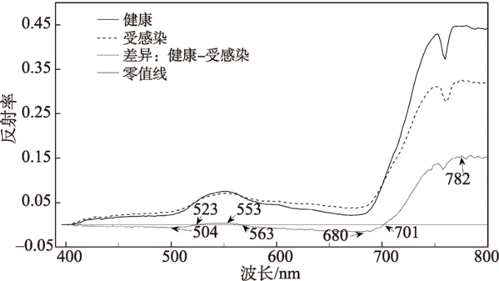
作物水分胁迫是由于供水不足导致的,水分胁迫会减少作物的蒸发蒸腾,引起叶片温度升高,并表现出叶片枯萎,发育迟缓和叶面积减少等症状[38],通过叶片的温度和光谱反射特征可以判定作物是否遭受水分胁迫。20世纪60年代起,热红外传感器监测植物水分状况被广泛应用[39],比较有代表性的是20世纪80年代Idso提出的作物水分胁迫指数(Crop Water Stress Index,CWSI)[40]。之后一系列的水分胁迫指数的提出为无人机遥感监测作物水分胁迫提供了强大的支撑,现阶段的水分胁迫无人机遥感监测主要采用无人机+热红外相机和无人机+多光谱相机获取作物冠层的温度和光谱反射率的方式实现。例如,Calderón等[26]利用热红外成像来监测橄榄黄萎病所引发的水分胁迫,并证实了叶片温度越高,气孔导度越低,指示的黄萎病也越严重;Bellvert等[27]用无人机和热红外相机获取葡萄的冠层温度,并用来计算作物水分胁迫指数,从而绘制整个葡萄园的水分胁迫地图,用于精确灌溉管理;Matese等[28]通过无人机搭载的热红外相机对位于地中海撒丁岛的葡萄园水分胁迫研究发现,CWSI可以作为评价葡萄园水分状况空间异质性的重要指标;Bellvert等[29]基于高分辨率热成像传感器绘制了不同葡萄园叶片水势(Leaf Water Potential, LWP)的空间异质性分布图,然后利用该信息进行灌溉调度;Gonzalez-Dugo等[30]利用从5种果树作物组成的农场中获取的的热红外图像确定了水分胁迫区域,并基于CWSI与茎水势(Stem Water Potential, SWP)之间的关系建立了基于CWSI的调度灌溉阈值;Zhao等[41]通过机载多光谱相机拍摄的影像监测杏仁农场的水分胁迫,发现归一化植被指数(Normalized Difference Vegetation Index, NDVI)和作物水分胁迫状况有很好的相关性。

(2)养分胁迫

养分作为作物的内部生理指标,关系到作物的健康及最终的产量。传统的化学分析方法检测作物胁迫,不仅存在着成本高、耗时长等缺点,而且还会对环境造成污染。利用无人机遥感技术非接触无损的获取作物的养分状况,则有效克服了传统手段的各种不足,有利于实现农业的信息化作业。不过现阶段的养分胁迫遥感监测更倾向于基于统计经验方法,这是由于像氮、磷、钾等养分元素的胁 迫光谱特征和遥感监测机理不够明确。例如, Zaman-Allah等[19]在玉米的氮素胁迫研究中发现,在无人机上安装的多光谱相机获取的氮胁迫指数和 玉米产量之间有很好的相关性,相关性0.40~0.79(p<0.05);Severtson等[20]通过无人机拍摄的多光谱图像监测澳大利亚西部钾缺乏的油菜田块,发现当图像的分辨率为65 mm(72%~100%)时比8 mm(69%~94%)时具有更高的分类精度;Roope等[14]通过无人机搭载的多光谱相机结合数码相机监测芬兰一个大麦农场的氮素水平,发现对于氮含量的估计值和实际测量值之间的皮尔逊相关系数和均方根误差分别达到了0.966和21.6%,但当单独使用数码相机或多光谱相机对氮含量进行估计时发现,多光谱相机在氮含量方面的估计优于RGB相机25%。

(3)其他胁迫

作物还会遭受高盐、低温和重金属等非生物胁迫。作物对高盐、低温等胁迫的反应包括:叶片脱落、叶片枯萎、叶片黄化甚至组织坏死等[42]。上述胁迫的光谱响应机制为遥感监测提供了依据,如 关丽等[23]应用高光谱遥感技术检测土壤镉污染下水稻叶片的叶绿素含量,用多重判别分析法检测叶绿素变化的敏感遥感参数,其中修正叶绿素吸收指数(Modified Chlorophyll Absorption in Reflectance Index,MCARI)最敏感,响应系数达0.59。相应的无人机遥感也能够应用于上述作物胁迫的精细识别,如李宗南等[15]利用无人机获取的玉米彩色图像提取倒伏面积,通过统计分析识别出宜于区分正常和倒伏玉米的色彩和纹理特征,结果表明正常和倒伏玉米的红绿蓝纹理特征差异明显,该方法用于提取玉米倒伏面积是行之有效的。杨浩等[32]发现合成孔径雷达(Synthetic Aperture Radar, SAR)极化特征对小麦倒伏十分敏感,并且基于这种敏感性,提出了一种基于SAR极化指数监测小麦倒伏的方法。

4 作物胁迫无人机遥感监测技术方法

可见光数码相机、多光谱相机、高光谱相机、热像仪、荧光探测仪、激光雷达和雷达通常是搭载于无人机遥感平台的主要传感器。但是受限于无人机遥感平台的载荷,以及传感器的成本等问题,目前无人机遥感作物胁迫监测中常用的传感器主要包括可见光数码相机、多光谱相机、高光谱相机、热像仪等,其他传感器用于作物胁迫的相关研究则比较少见[43]

4.1 基于光谱响应变异的作物胁迫监测

作物胁迫会在多个波段影响植被的光谱特性,因此不同胁迫的探测可以基于不同的光谱波段或不同光谱波段的组合实现[44]。患病作物通常会在叶片呈现出病斑、枯萎或坏死的区域,而这会导致在可见光区域反射率的增加,尤其是叶绿素的吸收带,同时红边(Red-edge, 670~730 nm)向短波方向移动。另外,感病植株在胁迫较严重时会出现叶倾角变化甚至植株倒伏等冠层形态的变化,从而在较大程度上影响近红外(NIR)波段的反射光谱[45]

4.1.1 基于特定光谱波段的作物胁迫监测

由于不同胁迫对作物造成的影响不同,因此不同的波段适合不同胁迫的监测,具有代表性的波段主要位于Red-edge和NIR波段附近,患病作物光谱反射率在可见光波段往往高于健康作物,而在近红外波段低于健康作物(图1)。下面从生物胁迫因素和非生物胁迫因素2个方面介绍相关研究进展。

图1   作物病虫害光学遥感探测敏感波段分布[22]

Fig. 1   Distribution of sensitive bands for optical remote sensing of crop stress

在杂草胁迫监测方面,López-Granados等[12]通过多旋翼无人机搭载的可见光和多光谱相机监测向日葵田处于早期物候阶段的杂草斑块,然后利用面向对象的分类方法对杂草、作物和裸土进行分类,通过设置不同的杂草阈值生成针对不同地点的除草剂使用地图,发现这对于杂草管理以及除草剂使用量的辅助决策具有重要意义。

在病虫害胁迫监测方面,冷伟锋等[37]通过无人机航拍图像获取的小麦冠层反射率、红色、绿色和蓝色波段的反射率与小麦条锈病病情指数之间的相关分析,发现4种反射率与病情指数均呈极显著相关,并由此构建了小麦条锈病病情指数的反演模型,证明了利用无人机遥感进行小麦条锈病监测的可行性。刘良云等[46]对比了3个生育期的患条锈病冬小麦与正常生长冬小麦的光谱图像及光谱特征,发现在560~670 nm黄边、红谷波段,患条锈病病 害冬小麦的冠层反射率高于正常生长的冬小麦。Jonathan等[21]的研究结果表明,通过无人机收集的多光谱图像中的Red-edge和NIR波段的数据可检测到作物对病虫害胁迫因素最早的生理应激反应。

在氮素胁迫监测方面,祝锦霞等[16]通过无人机拍摄的水稻可见光数码照片,发现蓝光最能反映水稻氮素水平的差异,并通过回归分析得到了通过蓝色波段计算氮素水平的氮素识别模型。Geipel等[47]将无人机获取的冬小麦多光谱图像处理为红边拐点(Red-edge Infiection Point, REIP)正射图像,并利用简单的线性回归模型对他们进行分析,结果表明利用REIP能够估算氮含量(RMSE为7.60%~11.7%)。Liu等[48]利用无人机携带的多光谱相机监测麦田的氮含量,发现利用R800,R700R490波段的组合具有最高的预测精度,对于叶片氮含量的预测精度高达R2=0.73。

在其它胁迫监测方面,Wang等[24]通过高光谱数据识别遭受冻害胁迫的越冬冬小麦,发现冻害胁迫发生后,“红峰”和“绿谷”的特征明显减弱,“红肩”处的反射率降低,且随着冻害严重性的增强,水分吸收谷的反射率会逐渐降低,证实了高光谱遥感监测作物冻害胁迫的实用价值。

通过上述研究可以发现,作物在面临不同胁迫时,其光谱特征响应位置具有明显的差异,但是目前用于作物胁迫监测的光谱波段主要位于可见光和近红外波段,对于其他波段的应用较少。随着无人机平台和高光谱传感器成本的不断下降,可以考虑通过利用光谱微分或者构建模型等方法,将更多的光谱波段利用起来,以期能更精准地对作物胁迫进行监测。

4.1.2 基于植被指数的作物胁迫监测

植被指数是作物胁迫监测最常用的一种手段,常用的作物胁迫监测植被指数如表3所示。通过无人机遥感影像计算植被指数进行作物胁迫监测常常能够获取比卫星遥感更精确的信息,尤其是对于作物胁迫早期的监测具有较大优势。下面将从生物胁迫因素和非生物胁迫因素2个方面介绍相关研究进展。

表3   作物胁迫探测常用植被指数

Tab. 3   Common vegetation indices for crop stress detection

指数名称指数公式胁迫类型参考文献编号
归一化植被指数NDVI=(NIR-R)(NIR+R)病虫害、水分、杂草、氮素[13]、[41]、[52]-[55]
比值植被指数SR=NIRR病虫害[53]
过绿指数ExG=2g-r-b
r=R(R+G+B)
g=G(R+G+B)
b=B(R+G+B)
杂草胁迫[13] [50]
归一化红绿差异指数NGRDI=(G-R)(G+R)杂草胁迫[50]
叶绿素吸收反射转化指数和优化土壤调节指数的比值TCARIOSAVI=3[R700-R670-0.2(R700-R550)(R700R670)](1+0.16)(R800-R670)/(R800+R670+0.16)水分胁迫[54]
红绿指数RGI=RG病虫害胁迫[51]
红绿植被指数GRVI=(G-R)(G+R)病虫害胁迫[51]
过红指数ExR=1.4R-G病虫害胁迫[17]
可见光大气阻抗植被指数VARI=(G-R)(G+R-B)氮素胁迫[18]
蓝光标准化值BLSV=B(R+G+B)氮素胁迫[18]
比值光谱指数RSI=R738R522氮素胁迫[25]
转化植被指数TVI=NDVI+0.5病虫害胁迫[53]
光化学反射指数PRI=(R570-R530)(R570+R530)水分胁迫[51]
标准化光化学指数PRInorm=PRI570[RDVI×(R700R670)]水分胁迫[51]
重归一化植被指数RDVI=(R800-R670)R800+R670水分胁迫[51]
修正叶绿素吸收指数MCARI=[R701-R671-0.2(R701-R549)](R701R671)重金属胁迫[23]

新窗口打开

在杂草胁迫监测方面,Castro等[49]通过机载相机获取的多光谱航空影像监测西班牙南部冬季作物(小麦、蚕豆、豌豆)中的十字花科杂草侵染水平,发现利用最大似然监督分类和R/B、B/G植被指数可以很好地区分杂草和作物。Jorge等[50]利用无人机搭载的可见光和多光谱相机识别向日葵田块中的杂草斑块,发现当飞行高度较低(30 m)时,归一化红绿差异指数(Normalised Green-Red Difference Index, NGRDI)和过绿指数(Excess Green Index, ExG)指数可以较好地区分作物、杂草和土壤,但是当飞行高度较高(60,100) m时,由于作物和杂草具有相似的光谱特征,分类错误显著增加,而NDVI具有更高的分类精度。Francisca等[13]通过搭载在无人机上的可见光谱和多光谱相机识别玉米田里的假高粱杂草分布,并利用ExG和NDVI指数通过面向对象的方法对杂草胁迫等级进行分类,据估计可以节约85%~96%的除草剂使用。

在病虫害胁迫监测方面,Zarco-Tejada等[51]通过无人机拍摄的多光谱图像监测法国南部感染葡萄金黄化病的葡萄园,在对比了5个光谱波段和11个植被指数和患病严重度之间的相关性之后,发现红色和绿色波段组合的红绿指数(Red-green Index, RGI)和红绿植被指数(Green-red Vegetation Index, GRVI)用于区分健康和患病植株具有最好的效果。Castro等[17]利用无人机携带的数码相机(RGB波段)拍摄的影像识别美国东南部感染月桂树枯萎病的牛油果树,通过将不同的波段、植被指数及其不同组合进行对比发现,过红指数(Excess Red, ExR)和B/G指数识别患病树木的精度最高。Nebiker等[52]发现利用无人机搭载的多光谱相机绘制的高分辨率NDVI地图,可以监测马铃薯晚疫病的早期感染。Zhao等[53]证实了比值植被指数(Simple Ratio, SR)和转化植被指数(Transformed Vegetation Index, TVI)对诊断小麦病害有较好的效果。

在水分胁迫监测方面,Zhao等[41]通过无人机搭载的多光谱相机监测加利福尼亚杏仁农场的水分胁迫,发现NDVI和作物水分胁迫状况有很好的相关性,随着水分胁迫状况的加重,NDVI的值会随之减小,且NDVI对处于不同生长阶段杏仁树的水分胁迫监测具有稳健性。Baluja等[54]通过无人机搭载的多光谱相机监测西班牙雨养商业葡萄园的水分胁迫状况,发现NDVI、叶绿素吸收反射转化指数和优化土壤调节指数的比值(Transformed Chlorophyll Absorption in Reflectance and Optimized Soil-adjusted Vegetation Index, TCARI/OSAVI)跟SWP和LWP均具有很好的相关性,分别是达到了(R2=0.86, P<0.05)和(R2=0.84, P<0.05)。

在氮素胁迫监测方面,Lisa等[55]使用无人机搭载的多光谱相机和地面多光谱仪对3个草场的氮含量进行监测,发现地面遥感和无人机遥感获取的NDVI值高度相关,相关性从0.83到0.97不等,并且将无人机获取的NDVI值跟草场氮含量进行相关分析,相关性最高达到了0.95,证实了无人机遥感评估草场的氮素胁迫的实用价值。李红军等[18]建立了基于不同高度的无人机航拍作物冠层数字图像诊断冬小麦和夏玉米氮素营养状态的模型,结果表明,可见光大气阻抗植被指数(Visible Light Atmospherically Resistant Vegetation Index, VARI)和蓝光标准化值[B/(R+G+B)]跟冬小麦和夏玉米实测氮素含量的决定系数分别达到了0.80和0.85。秦占飞等[25]基于无人机高光谱影像,对比分析光谱指数与偏最小二乘回归方法预测水稻叶片全氮含量的精确度和稳健性,结果表明以组合波段R738R522光谱反射率的一阶导数构成的比值光谱指数(Ratio Spectral Index, RSI)构建的线性模型为水稻叶片全氮含量的最优估测模型(R2为0.673, RMSE为0.329)。

通过上述研究可发现,目前常用于作物胁迫监测的植被指数主要由2~3个波段构成,随着高光谱传感器的不断发展,可考虑利用多元线性回归、人工神经网络、主成分分析等传统以及新兴的统计分析技术,充分利用高光谱遥感的优势,构建多波段组合的植被指数,以期更好地对各种作物胁迫进行监测。

4.2 基于热红外成像技术对作物胁迫进行监测

热红外成像技术是利用植物叶片的热量辐射进行成像的技术(辐射波长3~100 um)。植被的温度可以通过热像仪捕获的热辐射和植被辐射率进行估计,当叶片的气孔因为外界胁迫因素关闭时,会导致叶片温度的上升,因此可以通过监测叶温的变化诊断植株的受胁迫情况[56]。目前热红外成像技术主要应用于作物病虫害和水分胁迫的监测,而杂草和养分胁迫方面还少有报导。

在病虫害监测方面,Schmitz等[57]证实了通过航空遥感热成像技术监测甜菜冠层温度变化检测线虫感染田块的能力。Lili等[58]通过观察感染眼斑病和谷物囊肿的冬小麦的热效应,建议可以通过机载的空中即时热成像技术来监测和绘制作物病虫害分布图。这一方法后来被Nicolas用于监测冬小麦的三色虫感染,并且发现只有长得最高的小麦被感染时,健康小麦和患病小麦的温差才可以被检测到[59]。Leinonen和Jones[60]研究了在1~2 m高度的范围通过热成像技术监测葡萄树病虫害胁迫的可行性,并指出有阳光照射的叶片比阴影下的植物叶片平均温度要更高。因此,不同的叶片需要通过一个可视化反射相机来进行分离。

在水分胁迫监测方面,DeJonge等[61]通过比较6种基于热成像技术估算玉米水分胁迫的指数CWSI、非胁迫上限指数(Degrees Above Non-Stressed, DANS)、上层冠层阈值(Degrees Above Canopy Threshold, DACT)、时间温度阈值(Time Temperature Threshold, TTT)、整合非胁迫上限指数(Integrated Degrees Above Non-Stressed, IDANS)、整合上层冠层阈值(Degrees Above Canopy Threshold, IDACT)(表4),发现DANS和DACT和玉米水分胁迫程度的相关性最好。Baluja等[54]通过无人机拍摄的热红外影像计算的CWSI、气孔导度指数(Stomatal Conductance Indices, Ig)和第二气孔导度指数(Second Stomatal Conductance Indices, I3)估测葡萄园的水分胁迫,发现CWSI对水分胁迫的变化最敏感,其次是Ig,I3表现最差。Zarco-Tejada等[51]利用无人机拍摄的多光谱和热红外影像分析位于加利福尼亚的葡萄园水分胁迫状况,通过将标准化光化学指数PRInorm和光化学反射指数(Photochemical Reflectance Index, PRI)与CWSI进行对比发现,PRI跟葡萄园水分胁迫具有更高的相关性。

表4   常用的水分胁迫监测指数

Tab. 4   Common water stress monitoring index

指数名称公式参考文献编号
植被水分胁迫指数CWSI=(Tcanopy-Twet)/(Tdry-Twet)[28]、[30]、[40]、[51]、[61]
气孔导度指数Ig=(Tdry-Tcanopy)/(Tcanopy-Twet)[54]
第二气孔导度指数I3=(Tcanopy-Twet)/(Tdry-Tcanopy)[54]
非胁迫上限指数DANS=Tcanopy-TcNS[61]
上层冠层阈值DACT=max[0,Tcanopy-Tcritical][61]
时间温度阈值TTT=h=024h,whenTcanopy&gt;Tcritical[61]
整合非胁迫上限指数IDANS=h=024(Tcanopy-TcNS)dh[61]
整合上层冠层阈值IDACT=h=024max[0,(Tcanopy-Tcritical)]dh[61]

注:Tcanopy代表冠层温度,TdryTwet分别代表气孔完全关闭和完全打开时的下边界和上边界温度,Tcritical代表作物临界温度,TcNS代表临近区域非胁迫作物的冠层温度,h代表一天的24 h。

新窗口打开

虽然热红外成像技术在作物胁迫监测领域显示出了巨大的潜力,但是不得不提到的一点就是,热红外成像技术容易受复杂多变的环境因素的影响,如云、风和降雨等,而这都为热红外成像技术精确监测作物胁迫带来了极大的挑战。

5 问题与展望

无人机遥感因其高时空分辨率等优点,在作物胁迫监测方面正得到越来越多的应用。本文分别从无人机遥感平台、胁迫类型以及监测方法等方面梳理了目前无人机遥感技术在作物胁迫监测方面的应用情况。然而,无人机遥感在中国起步时间较晚,其技术开发和在作物胁迫监测方面的实际应用都还处于初级探索阶段,仍然存在很多不足。

5.1 问题

(1)无人机平台稳定性不足及大面积作业续航时间和载荷受限问题。目前中国大部分无人机遥感系统都是电池供电的,有效载荷不足15 kg,飞行时间通常为15~20 min,普遍存在载荷不足、航时较短的问题,这就极大限制了一次飞行可以覆盖的田块面积及携带的传感器数量,并且无人机由于质量轻,体积小,因此在空中容易受大风等恶劣天气的影响。因此,加快研发低成本、轻量化的传感器和自身稳定性强、续航时间长的无人机飞行平台是解决上述问题唯一方法。

(2)无人机图像处理问题。当前的图像处理 程序多是针对特定应用而开发的,缺乏一般化的程序[62]。随着利用无人机遥感监测田间作物胁迫的时间、空间和光谱分辨率的提高,同时也带来了海量遥感数据融合处理的问题,可是受限于计算机性能及数据处理方法,目前仍难以实现数据的在线实时处理。因此,开发出通用的数据处理算法或工具,提高图像的拼接、地理定位和自动信息提取能力,从多源遥感数据中提取出有用的作物胁迫信息,是无人机遥感应用于作物胁迫监测的关键因素之一。

(3)作物胁迫模型的适用性问题。由于不同作物的不同的胁迫往往具有相似的生理机制,而现阶段的经验模型多受作物所处的物候阶段、监测时间、太阳活动、作物种植区域、作物类型以及作物生育期等因素的影响,其时空局限性制约了模型的通用性推广。因此,加深对作物胁迫光谱特征的认识,对各种胁迫类型和光谱特征进行归纳总结,建立胁迫类型监测通用型模型,形成作物胁迫光谱类型和监测手段的标准方法库,对作物胁迫监测的实际应用具有重要意义。

5.2 展望

(1)实现“天-空-地”一体化的作物胁迫遥感监测体系

Shi等[63]2014年提出了“天-空-地”一体化的农业遥感监管体系,讨论了其在农田信息获取方面的优势及面临的挑战,并展望其在未来国家粮食安全中的应用前景。“天-空-地”一体化作物胁迫遥感监测体系中的“天”主要是指卫星遥感监测,它可以利用各种卫星提供的数据筛查作物胁迫事件,发现胁迫事件存在的可能性。“空”主要是指航空及近地遥感监测,它可以通过无人机现场飞行对胁迫事件进行确认。“地”主要是指地面站点监测,它可以对局部区域的胁迫状况进行精确的监测,也可以对卫星遥感和无人机遥感的监测精度进行评价和校正。“天-空-地”一体化的胁迫监测体系能够充分发挥各种监测手段的优势,形成立体的监测网络,从而提高作物胁迫评估的精度和可靠性,为作物管理与规划等提供科学依据。

(2) 结合遥感技术和物联网构建全国性作物胁迫实时监测与服务平台。

新型传感器技术和互联网的结合催生了物联网的诞生并飞速发展,从无人机遥感发展的趋势看,未来中国农业遥感的研究与应用将会在全国的物联网体系支持下开展。届时无人机和相应的传感器将可以实时的监测各种作物胁迫,并将具体状况上传至互联网平台。农民可能缺乏从无人机图像中提取可靠信息的必要技能,但遥感科学家可能不熟悉田间和作物条件。因此,综合遥感科学家和农民技能的方法可用于促进无人机遥感监测作物胁迫取得巨大的进步。全国性作物胁迫实时监测与服务平台的建立,能够方便用户通过专家系统进行胁迫诊断或咨询,以及不同地区之间的信息共享,实现对农业胁迫的实时监测和有效控制。

(3) 自主决策和执行任务的能力

在不久的未来,无人机遥感将会具备自主决策和执行任务的能力。无人机遥感系统在日本已经应用于自动播种和喷施农药。在农业中,最终的无人机应用场景将是航空遥感、实时图像处理和可变速率航空应用技术的组合,即实时的处理航拍图像以检索和诊断作物水分、害虫等胁迫信息,然后相应地使用可变速率喷洒农药等处理措施。届时目前精准农业的概念将向智慧农业的方向转化,无人机可以自主安排飞行进行图像处理并绘制胁迫地图,并以高水平的自主决策能力来管控作物胁迫。

(4) 无人机智能组网技术

利用云计算、物联网、移动通讯、人工智能等技术建立网络环境下数据驱动的空中移动无人机智能组网体系,实现无人机由单机向组网、人为控制向智能决策的跨越,不仅可以同时起飞多架次具备不同功能的遥感无人机,从而大大提高无人机遥感对作物胁迫事件的监测能力,更大限度地利用可以获得的各类信息资源,还可以通过无人机之间实时的信息共享极大的提高无人机的工作效率和生存能力。因此,实现无人机遥感智能感知、智能认知、智能行动一体化的组网观测技术,对未来大田及复杂地形条件下作物胁迫的监测和处理,以及特殊环境造成的作物胁迫(如冰雹、雨雪、土壤污染)的及时评估都具有重大的意义。

总体来说,无人机遥感有效弥补了卫星遥感、地面观测等传统手段在作物胁迫监测方面的不足,但是目前还存在着无人机飞行平台的稳定性差、有效载荷低和续航时间有限,以及缺乏通用的图像处理程序对获取的数据进行处理等不足。不过,相信大多数技术问题都可以通过新技术开发以及农学科学家和无人机系统工程师之间的合作来解决。预计在不久的未来,市场上将出现更耐用,功能更强大的无人机遥感平台,采用更先进的传感器技术,并将为大多数无人机系统配备标准化的图像自动处理程序。

The authors have declared that no competing interests exist.


参考文献

[1] 杜广平. 植物与植物生理[M].北京:北京大学出版社,2007.

[本文引用: 1]     

[ Du G P.Plant and plant physiology[M]. Beijing: Peking University press, 2007. ]

[本文引用: 1]     

[2] Martinelli F, Scalenghe R, Davino S, et al.

Advanced methods of plant disease detection. A review

[J]. Agronomy for Sustainable Development, 2015,35(1):1-25.

[本文引用: 1]     

[3] 廖小罕,周成虎,苏奋振,.

无人机遥感众创时代

[J].地球信息科学学报,2016,18(11):1439-1447.

URL      [本文引用: 1]     

[ Liao X H, Zhou C H,

Su F Z et al. The mass innovation era of UAV remote sensing

[J]. Journal of Geo-information Science, 2016,18(11):1439-1447. ]

URL      [本文引用: 1]     

[4] 杨海军,黄耀欢.

化工污染气体无人机遥感监测

[J].地球信息科学学报,2015,17(10):1269-1274.

https://doi.org/10.3724/SP.J.1047.2015.01269      Magsci      [本文引用: 1]      摘要

无人机大气环境监测虽然处于起步阶段,但已成为环保部门一项重要的工作内容,对于提高突发性大气污染事件的预防及应急监测具有重要意义。本文以化工污染气体排放高危区齐鲁化学工业区为研究区,利用搭载有高分辨率相机和污染气体监测仪的旋翼无人机(&#x0201c;环鹰一号&#x0201d;)系统,结合地面核查验证的方式,设计了一氧化氮(NO)、一氧化碳(CO)和二氧化硫(SO<sub>2</sub>)3种污染气体污染遥感监测流程及方法。通过实验区地面验证,以及150、200、250、350 m高度污染气体浓度监测结果分析表明,化工园区污染气体排放具有空间水平差异及垂直扩散特征,联合水平和垂直异常值分析,能为提前排查污染源排放提供有效支撑。本研究是无人机在环保部门大气环境监测中的实际应用,能为后续化工园区及重点企业污染物排放定期监管提供技术支持。

[ Yang H J, Huang Y H.

Evaluating atmospheric pollution of chemical plant based on unmanned aircraft vehicle(UAV)

[J]. Journal of Geo-information Science, 2015,17(10):1269-1274. ]

https://doi.org/10.3724/SP.J.1047.2015.01269      Magsci      [本文引用: 1]      摘要

无人机大气环境监测虽然处于起步阶段,但已成为环保部门一项重要的工作内容,对于提高突发性大气污染事件的预防及应急监测具有重要意义。本文以化工污染气体排放高危区齐鲁化学工业区为研究区,利用搭载有高分辨率相机和污染气体监测仪的旋翼无人机(&#x0201c;环鹰一号&#x0201d;)系统,结合地面核查验证的方式,设计了一氧化氮(NO)、一氧化碳(CO)和二氧化硫(SO<sub>2</sub>)3种污染气体污染遥感监测流程及方法。通过实验区地面验证,以及150、200、250、350 m高度污染气体浓度监测结果分析表明,化工园区污染气体排放具有空间水平差异及垂直扩散特征,联合水平和垂直异常值分析,能为提前排查污染源排放提供有效支撑。本研究是无人机在环保部门大气环境监测中的实际应用,能为后续化工园区及重点企业污染物排放定期监管提供技术支持。
[5] 金伟,葛宏立,杜华强,.

无人机遥感发展与应用概况

[J].遥感信息,2009(1):88-92.

https://doi.org/10.3969/j.issn.1000-3177.2009.01.017      URL      [本文引用: 1]      摘要

在阐述无人机发展历程基础上,论述了无人机在遥感领域的应用理论发展以及在气象监测、资源调查、航拍测量和应对突发事件等方面的应用,归纳了目前无人机遥感研究存在的问题,展望了今后无人机遥感研究的热点和重点。

[ Jin W, Ge H L, Du H Q, et al.

A review on unmanned aerial vehicle remote sensing and its application

[J]. Remote Sensing Information, 2009(1):88-92. ]

https://doi.org/10.3969/j.issn.1000-3177.2009.01.017      URL      [本文引用: 1]      摘要

在阐述无人机发展历程基础上,论述了无人机在遥感领域的应用理论发展以及在气象监测、资源调查、航拍测量和应对突发事件等方面的应用,归纳了目前无人机遥感研究存在的问题,展望了今后无人机遥感研究的热点和重点。
[6] 孙中宇,陈燕乔,杨龙,.

轻小型无人机低空遥感及其在生态学中的应用进展

[J].应用生态学报,2017,28(2):528-536.

[本文引用: 2]     

[ Sun Z Y, Chen Y Q, Yang L, et al.

Small unmanned aerial vehicles for low-altitude remote sensing and its application progress in ecolology

[J].

Chinese

[J].urnal of Applied Ecology, 2017,28(2):528-536. ]

[本文引用: 2]     

[7] 宋晓阳,黄耀欢,董东林,.

融合数字表面模型的无人机遥感影像城市土地利用分类

[J].地球信息科学学报,2018,20(5):703-711.

URL      [本文引用: 1]      摘要

城市土地利用是城市生态学中的关键问题,深入了解城市的土地利用对合理规划城市功能分区、提升用地效益、促进区域经济与环境发展具有重要意义.因此,城市土地利用类型分类研究一直是城市规划学和城市地理学研究的核心内容之一.快速发展的无人机技术为城市土地利用分类提供了丰富的数据支撑,基于无人机遥感影像建立的数字表面模型(DSM)和数字正射影像(DOM)可以有效提高城市土地利用分类的精度.为了充分利用无人机遥感影像的丰富信息,本文提出了一种融合高分辨率DOM和DSM的城市土地利用分类方法.本文融合了DOM和DSM作为数据源.在面向对象分类方法的基础上,DSM分别被用于多尺度分割过程中像元融合的最终阈值和地物分类过程中的地物高度特征.该方法在天津市宝坻区的京津新城进行了验证,结果表明,相对于最初的多尺度分割方法,融合DSM后的多尺度分割方法的分割质量指数(QR)、过分割指数(OR)、欠分割指数(UR)和综合指数(CR)都有所降低,分割效果明显提高.优化后的面向对象分类方法,在分类精度上有所提高,尤其是道路、建筑物和其他建设用地.总体精度由85%提高到了87.25%,Kappa系数由0.79提高到0.82.由此可看出,优化后的面向对象分类方法可以更有效地进行城市土地利用分类.

[ Song X Y, Huang Y H, Dong D L, et al.

Urban land use classification from UAV remote sensing images based on digital surface model

[J]. Journal of Geo-information Science, 2018,20(5):703-711.]

URL      [本文引用: 1]      摘要

城市土地利用是城市生态学中的关键问题,深入了解城市的土地利用对合理规划城市功能分区、提升用地效益、促进区域经济与环境发展具有重要意义.因此,城市土地利用类型分类研究一直是城市规划学和城市地理学研究的核心内容之一.快速发展的无人机技术为城市土地利用分类提供了丰富的数据支撑,基于无人机遥感影像建立的数字表面模型(DSM)和数字正射影像(DOM)可以有效提高城市土地利用分类的精度.为了充分利用无人机遥感影像的丰富信息,本文提出了一种融合高分辨率DOM和DSM的城市土地利用分类方法.本文融合了DOM和DSM作为数据源.在面向对象分类方法的基础上,DSM分别被用于多尺度分割过程中像元融合的最终阈值和地物分类过程中的地物高度特征.该方法在天津市宝坻区的京津新城进行了验证,结果表明,相对于最初的多尺度分割方法,融合DSM后的多尺度分割方法的分割质量指数(QR)、过分割指数(OR)、欠分割指数(UR)和综合指数(CR)都有所降低,分割效果明显提高.优化后的面向对象分类方法,在分类精度上有所提高,尤其是道路、建筑物和其他建设用地.总体精度由85%提高到了87.25%,Kappa系数由0.79提高到0.82.由此可看出,优化后的面向对象分类方法可以更有效地进行城市土地利用分类.
[8] 郭琪,童庆祥.

无人机在气象监测中的应用

[J].广东气象,2016,38(6):64-66.

[本文引用: 1]     

[ Guo Q, Tong Q X.

Application of uav in meteorological monitoring

[J]. Journal of Guangdong Meteorology, 2016,38(6):64-66. ]

[本文引用: 1]     

[9] Alheit K V, Busemeyer L, Liu W, et al.

Multiple-line cross QTL mapping for biomass yield and plant height in triticale

[J]. Theoretical and Applied Genetics, 2013,127(1):251-260.

[本文引用: 1]     

[10] Zhang C, Kovacs J M.

The application of small unmanned aerial systems for precision agriculture: a review

[J]. Precision Agriculture, 2012,13(6):693-712.

https://doi.org/10.1007/s11119-012-9274-5      URL      Magsci      [本文引用: 1]      摘要

AbstractPrecision agriculture (PA) is the application of geospatial techniques and sensors (e.g., geographic information systems, remote sensing, GPS) to identify variations in the field and to deal with them using alternative strategies. In particular, high-resolution satellite imagery is now more commonly used to study these variations for crop and soil conditions. However, the availability and the often prohibitive costs of such imagery would suggest an alternative product for this particular application in PA. Specifically, images taken by low altitude remote sensing platforms, or small unmanned aerial systems (UAS), are shown to be a potential alternative given their low cost of operation in environmental monitoring, high spatial and temporal resolution, and their high flexibility in image acquisition programming. Not surprisingly, there have been several recent studies in the application of UAS imagery for PA. The results of these studies would indicate that, to provide a reliable end product to farmers, advances in platform design, production, standardization of image georeferencing and mosaicing, and information extraction workflow are required. Moreover, it is suggested that such endeavors should involve the farmer, particularly in the process of field design, image acquisition, image interpretation and analysis.
[11] Cui J, Wang F, Dong X, et al.

Landmark extraction and state estimation for UAV operation in forest

[C]// Control conference. IEEE, 2013:5210-5215.

[本文引用: 1]     

[12] López-Granados F, Torres-Sánchez J, Serrano-Pérez A, et al.

Early season weed mapping in sunflower using UAV technology: variability of herbicide treatment maps against weed thresholds

[J]. Precision Agriculture, 2016,17(2):183-199.

[本文引用: 3]     

[13] López-Granados F, Torres-Sánchez J,

Castro A I D, et al. Object-based early monitoring of a grass weed in a grass crop using high resolution UAV imagery

[J]. Agronomy for Sustainable Development, 2016,36(4):67.

https://doi.org/10.1007/s13593-016-0405-7      URL      [本文引用: 3]      摘要

Sorghum halepense (johnsongrass) is a perennial weed with a vegetative reproductive system and one of the most competitive weeds in maize showing a spatial distribution in compact patches. When maize
[14] Roope Nasi, Niko Viljanen, Jere Kaivosoja, et al.

Estimating biomass and nitrogen amount of barley and grass using UAV and aircraft based spectral and photogrammetric 3D features

[J]. Remote Aens, 2018,10(7):1082.

[本文引用: 1]     

[15] 李宗南,陈仲新,王利民,.

基于小型无人机遥感的玉米倒伏面积提取

[J].农业工程学报,2014,30(19):207-213.

Magsci      [本文引用: 1]      摘要

该文使用2012年小型无人机遥感试验获取的红、绿、蓝彩色图像研究灌浆期玉米倒伏的图像特征和面积提取方法。研究首先计算和统计正常、倒伏玉米的30项色彩、纹理特征,然后比较特征的变异系数和相对差异评选出适宜区分正常、倒伏玉米的特征;通过分析发现,与红、绿、蓝色灰度比较,多项色彩、纹理特征的变异系数更大或不同类别间的相对差异更小,不适用于准确区分正常、倒伏玉米,最适于区分正常和倒伏玉米的特征是3项基于灰度共生矩阵的红、绿、蓝色均值纹理特征。分别基于色彩特征和评选出的纹理特征提取倒伏玉米面积,对比2种方法的误差发现,基于红、绿、蓝色均值纹理特征提取倒伏玉米面积的误差最小为0.3%,最大为6.9%,显著低于基于色彩特征提取方法的。该研究结果为应用无人机彩色遥感图像准确提取倒伏玉米面积提供了依据和方法。

[ Li Z N, Chen Z X, Wang L M, et al.

Area extraction of maize lodging based on remote sensing by small unmanned aerial vehicle

[J]. Transactions of the Chinese Society of Agricultural Engineering, 2014,30(19):207-213. ]

Magsci      [本文引用: 1]      摘要

该文使用2012年小型无人机遥感试验获取的红、绿、蓝彩色图像研究灌浆期玉米倒伏的图像特征和面积提取方法。研究首先计算和统计正常、倒伏玉米的30项色彩、纹理特征,然后比较特征的变异系数和相对差异评选出适宜区分正常、倒伏玉米的特征;通过分析发现,与红、绿、蓝色灰度比较,多项色彩、纹理特征的变异系数更大或不同类别间的相对差异更小,不适用于准确区分正常、倒伏玉米,最适于区分正常和倒伏玉米的特征是3项基于灰度共生矩阵的红、绿、蓝色均值纹理特征。分别基于色彩特征和评选出的纹理特征提取倒伏玉米面积,对比2种方法的误差发现,基于红、绿、蓝色均值纹理特征提取倒伏玉米面积的误差最小为0.3%,最大为6.9%,显著低于基于色彩特征提取方法的。该研究结果为应用无人机彩色遥感图像准确提取倒伏玉米面积提供了依据和方法。
[16] 祝锦霞,陈祝炉,石媛媛,.

基于无人机和地面数字影像的水稻氮素营养诊断研究

[J].浙江大学学报(农业与生命科学版),2010,36(1):78-83.

Magsci      [本文引用: 1]     

[ Zhu J X, Chen Z L, Shi Y Y, et al.

Diagnoses of rice nitrogen status based on spectral characteristics of leaf and canopy

[J].

Journal of Zhe

[J].ang University(Agricultural and Life Sciences), 2010,36(1):78-83.]

Magsci      [本文引用: 1]     

[17] Castro A I D, Ehsani R, Ploetz R C, et al.

Detection of laurel wilt disease in avocado using low altitude aerial imaging

[J]. Plos One, 2015,10(4):e0124642.

[本文引用: 1]     

[18] 李红军,李佳珍,雷玉平,.

无人机搭载数码相机航拍进行小麦、玉米氮素营养诊断研究

[J].中国生态农业学报,2017(12):1832-1841.

[本文引用: 1]     

[ Li H J, Li J Z, Lei Y P, et al.

Diagnosis of nitrogen nutrition of winter wheat and summer corn using images from digital camera equipped on unmanned aerial vehicle

[J]. Chinese Journal of Eco-Agriculture, 2017(12):1832-1841. ]

[本文引用: 1]     

[19] Zamanallah M, Vergara O, Araus J L, et al.

Unmanned aerial platform-based multi-spectral imaging for field phenotyping of maize

.[J]. Plant Methods, 2015,11(1):35.

[本文引用: 1]     

[20] Severtson D, Callow N, Flower K, et al.

Unmanned aerial vehicle canopy reflectance data detects potassium deficiency and green peach aphid susceptibility in canola

[J]. Precision Agriculture, 2016,17(6):659-677.

[本文引用: 1]     

[21] Dash J P, Watt M S, Pearse G D, et al.

Assessing very high resolution UAV imagery for monitoring forest health during a simulated disease outbreak

[J].

International

[J].urnal of Photogrammetry & Remote Sensing, 2017,131:1-14.

[本文引用: 1]     

[22] Vanegas F, Bratanov D, Powell K, et al.

A novel methodology for iimproving plant pest surveillance in vineyards and crops using UAV-based hyperspectral and spatial data

.[J]. Sensors, 2018,18(1):260.

https://doi.org/10.3390/s18010260      URL      [本文引用: 2]      摘要

Recent advances in remote sensed imagery and geospatial image processing using unmanned aerial vehicles (UAVs) have enabled the rapid and ongoing development of monitoring tools for crop management and the detection/surveillance of insect pests. This paper describes a (UAV) remote sensing-based methodology to increase the efficiency of existing surveillance practices (human inspectors and insect traps) for detecting pest infestations (e.g., grape phylloxera in vineyards). The methodology uses a UAV integrated with advanced digital hyperspectral, multispectral, and RGB sensors. We implemented the methodology for the development of a predictive model for phylloxera detection. In this method, we explore the combination of airborne RGB, multispectral, and hyperspectral imagery with ground-based data at two separate time periods and under different levels of phylloxera infestation. We describe the technology used he sensors, the UAV, and the flight operations he processing workflow of the datasets from each imagery type, and the methods for combining multiple airborne with ground-based datasets. Finally, we present relevant results of correlation between the different processed datasets. The objective of this research is to develop a novel methodology for collecting, processing, analysing and integrating multispectral, hyperspectral, ground and spatial data to remote sense different variables in different applications, such as, in this case, plant pest surveillance. The development of such methodology would provide researchers, agronomists, and UAV practitioners reliable data collection protocols and methods to achieve faster processing techniques and integrate multiple sources of data in diverse remote sensing applications.
[23] 关丽,刘湘南,程承旗.

土壤镉污染环境下水稻叶片叶绿素含量监测的高光谱遥感信息参数

[J].光谱学与光谱分析,2009,29(10):2713-2716.

[本文引用: 1]     

[ Guan L, Liu X N, Cheng C Q.

Research on hyperspectral information parameters of chlorophyll content of rice leaf in cd-polluted soil environment

[J]. Spectroscopy and Spectral Analysis, 2009,29(10):2713-2716. ]

[本文引用: 1]     

[24] Wang H, Wang J, Wang Q, et al.

Hyperspectral characteristics of winter wheat under freezing injury stress and LWC inversion model

[C]// First International Conference on Agro-Geoinformatics. IEEE, 2012:1-6.

[本文引用: 1]     

[25] 秦占飞,常庆瑞,谢宝妮,.

基于无人机高光谱影像的引黄灌区水稻叶片全氮含量估测

[J].农业工程学报,2016,32(23):77-85.

[本文引用: 1]     

[ Qin Z F, Chang Q R, Xie B N, et al.

Rice leaf nitrogen content estimation based on hyperspectral imagery of UAV in Yellow River diversion irrigation district

[J]. Transactions of the Chinese Society of Agricultural Engineering, 2016,32(23):77-85. ]

[本文引用: 1]     

[26] Calderón R, Navas-Cortés J A, Lucena C, et al.

High-resolution airborne hyperspectral and thermal imagery for early detection of Verticillium, wilt of olive using fluorescence, temperature and narrow-band spectral indices

[J]. Remote Sensing of Environment, 2013,139(139):231-245.

https://doi.org/10.1016/j.rse.2013.07.031      URL      [本文引用: 1]      摘要

61Early detection of Verticillium wilt (VW) was investigated with remote sensing61Leaf data and airborne imagery correlated with physiology status due to the disease61Crown temperature (Tc-Ta, CWSI) were effective in detecting VW at early stages61Hyperspectral indices B, BG1, BR1 and fluorescence detected VW at early stages61Structural indices (NDVI) and pigment indices were good only to assess damage
[27] Bellvert J, Zarco-Tejada P J, Girona J, et al.

Mapping crop water stress index in a 'Pinot-noir' vineyard: comparing ground measurements with thermal remote sensing imagery from an unmanned aerial vehicle

[J]. Precision Agriculture, 2014,15(4):361-376.

https://doi.org/10.1007/s11119-013-9334-5      Magsci      [本文引用: 1]      摘要

Characterizing the spatial variability in water status across vineyards is a prerequisite for precision irrigation. The crop water stress index (CWSI) indicator was used to map the spatial variability in water deficits across an 11-ha 'Pinot noir' vineyard. CWSI was determined based on canopy temperatures measured with infrared temperature sensors placed on top of well-watered and water-stressed grapevines in 2009 and 2010. CWSI was correlated with leaf water potential (I-L) (R (2) = 0.83). This correlation was also tested with results from high resolution airborne thermal imagery. An unmanned aerial vehicle equipped with a thermal camera was flown over the vineyard at 07:30, 09:30, and 12:30 h (solar time) on 31 July 2009. At about the same time, I-L was measured in 184 grapevines. The image obtained at 07:30 was not useful because it was not possible to separate soil from canopy temperatures. Using the airborne data, the correlation between CWSI and I-L had an R (2) value of 0.46 at 09:30 h and of 0.71 at 12:30 h, suggesting that the latter was the more favorable time for obtaining thermal images that were linked with I-L values. A sensitivity analysis of varying pixel size showed that a 0.3 m pixel was needed for precise CWSI mapping. The CWSI maps thus obtained by airborne thermal imagery were effective in assessing the spatial variability of water stress across the vineyard.
[28] Matese A, Baraldi R, Berton A, et al.

Estimation of water stress in grapevines using proximal and remote sensing methods

[J]. Remote Sensing, 2018,10(1):114.

[本文引用: 1]     

[29] Bellvert J, Zarco-Tejada P J, Gonzalez-Dugo V, et al.

Scheduling vineyard irrigation based on mapping leaf water potential from airborne thermal images

[C]// European Conference in Precision Agriculture. 2013:699-704.

[本文引用: 1]     

[30] Gonzalez-Dugo V, Zarco-Tejada P, Nicolás E, et al.

Using high resolution UAV thermal imagery to assess the variability in the water status of five fruit tree species within a commercial orchard

[J]. Precision Agriculture, 2013,14(6):660-678.

https://doi.org/10.1007/s11119-013-9322-9      Magsci      [本文引用: 1]      摘要

This paper deals with the assessment of heterogeneity in water status in a commercial orchard, as a prerequisite for precision irrigation management. Remote sensing-derived indicators could be suitable for mapping water stress over large areas, and recent studies have demonstrated that high resolution airborne thermal imagery enables the assessment of discontinuous canopies as pure tree crowns can be targeted, thus eliminating the background effects. Airborne campaigns were conducted over a drip-irrigated commercial orchard in Southwestern Spain composed of five different orchard tree crops. An unmanned aerial vehicle with a thermal camera onboard was flown three times during the day on 8 July 2010, at 9, 11 and 13 h (local time). Stem water potential was measured at the same time of the flights. In some irrigation units, irrigation was stopped prior to the measurement date to induce water deficits for comparative purposes. Several approaches for using the thermal data were proposed. Daily evolution of the differential between canopy and air temperature (T (c) - T (a) ) was compared to tree water status. The slope of the evolution of T (c) - T (a) with time was well correlated with water status and is proposed as a novel indicator linked with the stomatal behavior. The Crop Water Stress Index (CWSI) was calculated with the temperature data from the 13.00 h flight using an empirical approach for defining the upper and lower limits of T (c) - T (a) . The assessment of variability in water status was also performed using differences in relative canopy temperatures. Ample variability was detected among and within irrigation units, demonstrating that the approach proposed was viable for precision irrigation management. The assessment led to the identification of water-stressed areas, and to the definition of threshold CWSI values and associated risks. Such thresholds may be used by growers for irrigation management based on crop developmental stages and economic considerations.
[31] 杨凡.

基于无人机激光雷达和高光谱的冬小麦生物量反演研究

[D].西安:西安科技大学,2017.

[ Yang F.

Estimation of winter wheat aboveground biomass with UAV LiDAR and hyperspectral data

[D]. Xi'an: Xi'an University of Science andTechnology, 2017]

[32] 杨浩,杨贵军,顾晓鹤,.

小麦倒伏的雷达极化特征及其遥感监测

[J].农业工程学报,2014,30(7):1-8.

Magsci      [本文引用: 1]      摘要

研究探索了雷达遥感大面积监测小麦倒伏状况的潜力。利用覆盖整个小麦生育期的5景时间序列Radarsat-2全极化影像数据,对比分析了倒伏小麦与正常小麦在不同时间、不同极化的雷达后向散射动态响应规律,发现雷达极化特征对小麦倒伏十分敏感,基于此提出利用雷达极化指数监测小麦倒伏的方法。并利用内蒙古额尔古纳市上库力农场春小麦抽穗灌浆期的实地调查数据,对提出方法进行验证,结果表明该方法能有效辨识和监测小麦倒伏。为大面积监测小麦倒伏提供了一种简单、快速、有效的手段。

[ Yang H, Yang G J, Gu X H, et al.

Radar polarimetric response features and remote sensing monitoring of wheat lodging

[J]. Transactions of the Chinese Society of Agricultural Engineering, 2014,30(7):1-8. ]

Magsci      [本文引用: 1]      摘要

研究探索了雷达遥感大面积监测小麦倒伏状况的潜力。利用覆盖整个小麦生育期的5景时间序列Radarsat-2全极化影像数据,对比分析了倒伏小麦与正常小麦在不同时间、不同极化的雷达后向散射动态响应规律,发现雷达极化特征对小麦倒伏十分敏感,基于此提出利用雷达极化指数监测小麦倒伏的方法。并利用内蒙古额尔古纳市上库力农场春小麦抽穗灌浆期的实地调查数据,对提出方法进行验证,结果表明该方法能有效辨识和监测小麦倒伏。为大面积监测小麦倒伏提供了一种简单、快速、有效的手段。
[33] Peña J M, Torressánchez J, Serranopérez A, et al.

Quantifying efficacy and limits of unmanned aerial vehicle (UAV) technology for weed seedling detection as affected by sensor resolution

[J]. Sensors, 2015,15(3):5609-26.

https://doi.org/10.3390/s150305609      URL      PMID: 25756867      [本文引用: 1]      摘要

In order to optimize the application of herbicides in weed-crop systems, accurate and timely weed maps of the crop-field are required. In this context, this investigation quantified the efficacy and limitations of remote images collected with an unmanned aerial vehicle (UAV) for early detection of weed seedlings. The ability to discriminate weeds was significantly affected by the imagery spectral (type of camera), spatial (flight altitude) and temporal (the date of the study) resolutions. The colour-infrared images captured at 40 m and 50 days after sowing (date 2), when plants had 5鈥6 true leaves, had the highest weed detection accuracy (up to 91%). At this flight altitude, the images captured before date 2 had slightly better results than the images captured later. However, this trend changed in the visible-light images captured at 60 m and higher, which had notably better results on date 3 (57 days after sowing) because of the larger size of the weed plants. Our results showed the requirements on spectral and spatial resolutions needed to generate a suitable weed map early in the growing season, as well as the best moment for the UAV image acquisition, with the ultimate objective of applying site-specific weed management operations.
[34] Strange R N, Scott P R.

Plant disease: A threat to global food security

[J]. Annual Review of Phytopathology, 2005,43(1):83-116.

[本文引用: 1]     

[35] 张竞成,袁琳,王纪华,.

作物病虫害遥感监测研究进展

[J].农业工程学报,2012,28(20):1-11.

Magsci      [本文引用: 1]      摘要

农作物病虫害监测目前在数据采集上主要依靠植保人员田间调查、田间取样等传统方式,不仅耗时、费力,而且存在以点代面的代表性差、主观性强和时效性差等弊端,难以满足大范围病虫害实时监测的需求。近年来遥感技术的发展,为大面积、快速获取作物和环境信息提供了重要的手段,是未来大面积病虫害监测和预测预报与产量损失评估的重要手段。该文在阐述植物病虫害胁迫光谱响应的生理机制的基础上,对目前病虫害遥感监测中所常用的光谱敏感波段及植被指数进行了汇总、整理,并对病虫害识别、严重度监测和损失评估等方面所使用的算法进行了综述。在此基础上,指出了目前作物病虫害遥感监测中尚需解决的关键技术问题,并就如何实现大面积作物病虫害遥感监测提出了解决思路。

[ Zhang J C, Yuan L, Wang J H, et al.

Research progress of crop diseases and pests monitoring based on remote sensing

[J]. Transactions of the Chinese Society of Agricultural Engineering, 2012,28(20):1-11. ]

Magsci      [本文引用: 1]      摘要

农作物病虫害监测目前在数据采集上主要依靠植保人员田间调查、田间取样等传统方式,不仅耗时、费力,而且存在以点代面的代表性差、主观性强和时效性差等弊端,难以满足大范围病虫害实时监测的需求。近年来遥感技术的发展,为大面积、快速获取作物和环境信息提供了重要的手段,是未来大面积病虫害监测和预测预报与产量损失评估的重要手段。该文在阐述植物病虫害胁迫光谱响应的生理机制的基础上,对目前病虫害遥感监测中所常用的光谱敏感波段及植被指数进行了汇总、整理,并对病虫害识别、严重度监测和损失评估等方面所使用的算法进行了综述。在此基础上,指出了目前作物病虫害遥感监测中尚需解决的关键技术问题,并就如何实现大面积作物病虫害遥感监测提出了解决思路。
[36] 乔红波,师越,司海平,.

基于无人机数字图像与高光谱数据融合的小麦全蚀病等级的快速分类技术

[J].植物保护,2015,41(6):157-162.

[本文引用: 1]     

[ Qiao H B, Shi Y, Si H P, et al.

Fast multi-classification of wheat take-all levels based on the fusion of unmanned aerial vehicle digital images and spectral data

[J]. Plant Protection, 2015,41(6):157-162. ]

[本文引用: 1]     

[37] 冷伟锋,王海光,胥岩,.

无人机遥感监测小麦条锈病初探

[J].植物病理学报,2012,42(2):202-205.

Magsci      [本文引用: 2]     

[ Leng W F, Wang H G, Xu Y, et al.

Preliminary study on monitoring wheat stripe rust with using UAV

[J]. Acta Phytopathologica Sinica, 2012,42(2):202-205. ]

Magsci      [本文引用: 2]     

[38] Wang X, Zhao C, Guo N, et al.

Determining the canopy water stress for spring wheat using canopy hyperspectral reflectance data in loess plateau semiarid regions

[J]. Spectroscopy Letters, 2015,48(7):7.

[本文引用: 1]     

[39] Fuchs M, Tanner C B.

Infrared thermometry of vegetation

[J].

Agronomy

[J].urnal, 1962,58(6):597-601.

[本文引用: 1]     

[40] Idso S B, Jackson R D,

Jr P J P, et al. Normalizing the stress-degree-day parameter for environmental variability

[J]. Agricultural Meteorology, 1981,24(1):45-55.

[本文引用: 1]     

[41] Zhao T, Stark B, Chen Y Q, et al.

Challenges in water stress quantification using small unmanned aerial system (sUAS): Lessons from a growing season of almond

[C]// International Conference on Unmanned Aircraft Systems. IEEE, 2016:1366-1370.

[本文引用: 2]     

[42] Chen S Y,Zhang S, Liu P, et al.

Plant stress related protein GmSIK1 and encoding gene and use thereof: US, US 20120266325 A1[P].

2012.

[本文引用: 1]     

[43] 刘建刚,赵春江,杨贵军,.

无人机遥感解析田间作物表型信息研究进展

[J].农业工程学报,2016,32(24):98-106.

[本文引用: 1]     

[ Liu J G, Zhao C J, Yang G J, et al.

Review of field-based phenotyping by unmanned aerial vehicle remote sensing platform

[J]. Transactions of the Chinese Society of Agricultural Engineering, 2016,32(24):98-106. ]

[本文引用: 1]     

[44] Genderen V J L.

Advances in environmental remote sensing: Sensors, algorithms and applications

[J].

International

[J].urnal of Digital Earth, 2011,4(5):446-447.

[本文引用: 1]     

[45] 黄文江. 作物病害遥感监测机理与应用[M].北京:中国农业科学技术出版社,2009.

[本文引用: 1]     

[ Huang W J.Mechanism and application of remote sensing monitoring of crop diseases[M]. Beijing: China Agricultural Science and Technology Press, 2009. ]

[本文引用: 1]     

[46] 刘良云,黄木易,黄文江,.

利用多时相的高光谱航空图像监测冬小麦条锈病

[J].遥感学报,2004,8(3):275-281.

https://doi.org/10.11834/jrs.20040313      Magsci      [本文引用: 1]      摘要

冬小麦发生锈病 ,叶绿素被大量破坏 ,水分蒸滕量大大增加 ,叶片细胞大小、形态、叶片结构发生了改变 ,从而改变了叶片和冠层的光学特性 ,使得遥感探测与评价成为可能。利用多时相的高光谱航空飞行图像数据 ,了解、分析和发现条锈病病害对作物光谱的影响及其光谱特征 ;设计了病害光谱指数 ,成功地监测了冬小麦条锈病病害程度与范围。对比 3个生育期的条锈病与正常生长冬小麦的PHI图像光谱及光谱特征 ,发现 :5 6 0― 6 70nm黄边、红谷波段 ,条锈病病害冬小麦的冠层反射率高于正常生长的冬小麦光谱反射率 ;近红外波段 ,条锈病病害的冠层反射率低于正常生长的冬小麦光谱反射率 ;条锈病冬小麦冠层光谱红谷吸收深度和绿峰的反射峰高度都会减小

[ Liu L Y, Huang M Y, Huang W J, et al.

Monitoring stripe rust disease of winter wheat using multi-temporal hyperspectral airborne data

[J]. Journal of Remote Sensing, 2004,8(3):275-281.]

https://doi.org/10.11834/jrs.20040313      Magsci      [本文引用: 1]      摘要

冬小麦发生锈病 ,叶绿素被大量破坏 ,水分蒸滕量大大增加 ,叶片细胞大小、形态、叶片结构发生了改变 ,从而改变了叶片和冠层的光学特性 ,使得遥感探测与评价成为可能。利用多时相的高光谱航空飞行图像数据 ,了解、分析和发现条锈病病害对作物光谱的影响及其光谱特征 ;设计了病害光谱指数 ,成功地监测了冬小麦条锈病病害程度与范围。对比 3个生育期的条锈病与正常生长冬小麦的PHI图像光谱及光谱特征 ,发现 :5 6 0― 6 70nm黄边、红谷波段 ,条锈病病害冬小麦的冠层反射率高于正常生长的冬小麦光谱反射率 ;近红外波段 ,条锈病病害的冠层反射率低于正常生长的冬小麦光谱反射率 ;条锈病冬小麦冠层光谱红谷吸收深度和绿峰的反射峰高度都会减小
[47] Geipel J, Link J, Wirwahn J, et al.

A programmable aerial multispectral camera system for in-season crop biomass and nitrogen content estimation

[J]. Agriculture, 2016,6(1):4.

[本文引用: 1]     

[48] Liu Y, Cheng T, Zhu Y, et al.

Comparative analysis of vegetation indices, non-parametric and physical retrieval methods for monitoring nitrogen in wheat using UAV-based multispectral imagery

[C]// Geoscience and Remote Sensing Symposium. IEEE, 2016:7362-7365.

[本文引用: 1]     

[49] Castro A I D, Jurado-Expósito M, Peña-Barragán J M, et al.

Airborne multi-spectral imagery for mapping cruciferous weeds in cereal and legume crops

[J]. Precision Agriculture, 2012,13(3):302-321.

https://doi.org/10.1007/s11119-011-9247-0      URL      Magsci      [本文引用: 1]      摘要

AbstractCruciferous weeds are competitive broad-leaved species that cause losses in winter crops. In the present study, research on remote sensing was conducted on seven naturally infested fields located in C贸rdoba and Seville, southern Spain. Multi-spectral aerial images (four bands, including blue (B), green (G), red (R) and near-infrared bands) taken in April 2007 were used to evaluate the feasibility of mapping cruciferous patches (Diplotaxis spp. and Sinapis spp.) in winter crops (wheat, broad bean and pea) and compare the accuracy of different supervised classification methods (vegetation indices, maximum likelihood and spectral angle mapper). The best classification method was selected to develop site-specific cruciferous treatment maps. Cruciferous patches were efficiently discriminated with red/blue (R/B) and blue/green (B/G) vegetation indices and the maximum likelihood classifier. At all of the locations, the accuracy of the results obtained from the spectral angler mapper was relatively low. The cruciferous weed-classified imagery of each location were created according to the method that provided the best discrimination results and were used to obtain site-specific treatment maps for in-season post-emergence control measures or herbicide applications for subsequent years. By applying the site-specific treatment maps, herbicide savings from 71.7 to 95.4% for the no-treatment areas and from 4.3 to 12% for the low-dose herbicide were obtained.
[50] Jorge T S, Francisca L G, Isabel D C A, et al.

Configuration and specifications of an unmanned aerial vehicle (UAV) for early site specific weed management

[J]. Plos One, 2013,8(3):e58210.

[本文引用: 1]     

[51] Zarco-Tejada P J, González-Dugo V, Williams L E, et al.

A PRI-based water stress index combining structural and chlorophyll effects: Assessment using diurnal narrow-band airborne imagery and the CWSI thermal index

[J]. Remote Sensing of Environment, 2013,138(138):38-50.

[本文引用: 2]     

[52] Nebiker S, Lack N, Abächerli M, et al. Light-weight multispectral UAV sensors and their capabilities for predicting grain yield and detecting plant diseases[J]. ISPRS-International Archives of the Photogrammetry, Remote Sensing and Spatial Information Sciences, 2016,

XLI-

B1:963-970.

[本文引用: 1]     

[53] Zhao C, Huang M, Huang W, et al.

Analysis of winter wheat stripe rust characteristic spectrum and establishing of inversion models

[C]// IEEE International Geoscience & Remote Sensing Symposium. IEEE, 2004.

[本文引用: 1]     

[54] Baluja J, Diago M P, Balda P, et al.

Assessment of vineyard water status variability by thermal and multispectral imagery using an unmanned aerial vehicle (UAV)

[J]. Irrigation Science, 2012,30(6):511-522.

https://doi.org/10.1007/s00271-012-0382-9      Magsci      [本文引用: 2]      摘要

The goal of this study was to assess the water status variability of a commercial rain-fed Tempranillo vineyard (Vitis vinifera L.) by thermal and multispectral imagery using an unmanned aerial vehicle (UAV). The relationships between aerial temperatures or indices derived from the imagery and leaf stomatal conductance (g (s)) and stem water potential (I-stem) were determined. Aerial temperature was significantly correlated with g (s) (R (2) = 0.68, p < 0.01) and I-stem (R (2) = 0.50, p < 0.05). Furthermore, the thermal indices derived from aerial imagery were also strongly correlated with I-stem and g (s). Moreover, different spectral indices were related to vineyard water status, although NDVI (normalized difference vegetation index) and TCARI/OSAVI (ratio between transformed chlorophyll absorption in reflectance and optimized soil-adjusted vegetation index) showed the highest coefficient of determination with I-stem (R (2) = 0.68, p < 0.05) and g (s) (R (2) = 0.84, p < 0.05), respectively. While the relationship with thermal imagery and water status parameters could be considered as a short-term response, NDVI and TCARI/OSAVI indices were probably reflecting the result of cumulative water deficits, hence a long-term response. In conclusion, thermal and multispectral imagery using an UAV allowed assessing and mapping spatial variability of water status within the vineyard.
[55] Lisa C, Matteo C, Monica G, et al.

Unmanned aerial vehicle to estimate nitrogen status of turfgrasses

[J]. Plos One, 2016,11(6):e0158268.

[本文引用: 1]     

[56] Lee W S, Alchanatis V, Yang C, et al.

Review: Sensing technologies for precision specialty crop production

[J]. Computers & Electronics in Agriculture, 2010,74(1):2-33.

[本文引用: 1]     

[57] Schmitz A, Kiewnick S, Schlang J, et al.

Use of high resolution digital thermography to detect Heterodera schachtii infestation in sugar beets

[J]. Commun Agric Appl Biol Sci, 2004,69(3):359-363.

[本文引用: 1]     

[58] Lili Z, Duchesne J, Nicolas H, et al.

Détection infrarouge thermique des maladies du blé d'hiver

[J]. Eppo Bulletin, 1991,21(3):659-672.

[本文引用: 1]     

[59] Nicolas H, Stafford J V.

Use of remote sensing within the optical and thermal spectral ranges in order to detect Septoria tritici on winter wheat

[C]// Precision agriculture '05. Papers presented at the 5th European Conference on Precision Agriculture, Uppsala, Sweden, 2005:81-89.

[本文引用: 1]     

[60] Leinonen I, Jones H G.

Combining thermal and visible imagery for estimating canopy temperature and identifying plant stress

[J]. Journal of Experimental Botany, 2004,55(401):1423-1431.

[本文引用: 1]     

[61] Dejonge K C, Taghvaeian S, Trout T J, et al.

Comparison of canopy temperature-based water stress indices for maize

[J]. Agricultural Water Management, 2015,156:51-62.

[本文引用: 1]     

[62] Hardin P, Jensen R.

Small-scale unmanned aerial vehicles in environmental remote sensing: Challenges and opportunities

[J]. Mapping Sciences & Remote Sensing, 2011,48(1):99-111.

[本文引用: 1]     

[63] Shi Y, Ji S P, Shao X W, et al.

Framework of SAGI agriculture remote Sensing and its perspectives in supporting national food security

[J]. Journal of Integrative Agriculture, 2014,13(7):1443-1450.

[本文引用: 1]     

/