

1 引言
连续的陆地表面包含多种地貌,每种地貌都具有不同的视觉和物理特征,这些地貌是由自然原因形成的独特可识别的地形单元[1]。地貌识别是地貌学研究的重要内容之一,是进行地貌分类和认识地貌过程的重要工具,已经成为了当前地貌学领域的研究热点。
目前基于地貌单元的地貌识别方法主要有基于像素单元和面向对象两种方法,以此为基础,学者们一般是根据地表形态特征对地貌进行识别[5⇓-7]。地表形态是最基本的自然地理要素,由不同的地形特征要素组合而成,它的描述和表达是地貌学、地理学等多学科研究的核心命题和重要内容[8]。地形特征因子是可以有效地表达地表形态的参数[9]。目前在地表形态的描述方面,已然形成了一整套成熟的地形特征分析方法和指标体系,在地貌定量分析、识别、分类[10]等系列研究中拥有着极为广泛的应用,成为了数字地形分析的理论支撑和应用基石。如:陈楹等[3]基于地形形态进行空间统计特征分析的褶皱地貌类型自动识别,曹伟超等[7]使用最佳地形特征空间分析方法进行地貌形态的自动识别,赵武凡等[6]构建了地形导数和纹理导数集成的数据集,量化地形特征后进行地貌识别。这些研究一般以地形特征或纹理特征量化地表的形态特征,从而实现了不同地貌类型的识别。
基于地貌空间结构的地貌描述和表达成为了地貌定量分析的一个新热点,也为对地貌进行精确提取从而进行地貌识别提供了一个新方向[11-12]。地貌的空间结构是地貌学的核心命题[13],是地貌发育演化的基本背景[14-15]。地貌空间结构和组合特征是地貌的基本属性,是定量描述和表达地貌的一种全新视角。复杂网络是众多学科和领域广泛交叉的一门学科,通过网络的形式去表达系统要素之间的关系,可以有效刻画和定量描述系统的结构特征以及拓扑规律,在交通运输[16]、土地利用变化[17]、互联网[18]等领域拥有着广泛的应用。近年来,它逐渐扩展到地球科学领域,学者们基于此构建地貌的各种网络结构,也取得了一系列丰富的成果[19⇓⇓⇓⇓-24]。复杂网络方法通过模拟地貌空间结构,研究网络空间结构的特征,考虑各种地形特征点之间的拓扑关系,以定量描述地貌空间结构与形态特征以及地貌要素间的变化规律。如:贺卓文等[25]借助复杂网络理论研究了黄土高原沟谷地貌特征,对沟谷地貌的整体性描述和网络结构特征展开研究。田剑等[26]采用复杂网络理论研究黄土高原丘陵沟壑区小流域系统,描述流域网络并分析网络特征。复杂网络的形成与发展为地貌的拓扑关系、内部组成、结构特征等研究提供更多的见解,为地貌识别、地貌分类、地貌综合、地貌演化等提供了一个有效的切入点。虽然它已经被应用到地貌研究中,但很少涉及集水区地貌空间结构以及地貌识别的应用研究。
近年来,因集水区具有明确的地学意义和清晰的地理分界线,基于集水区的地貌识别方法受到了面向对象地貌识别领域的学者们的广泛关注,如林偲蔚[27]基于DEM数据对黄土高原地区展开地貌识别研究,贺中华等[28]对喀斯特水系提取并进行地貌类型的识别。集水区作为基本的地貌单元,是地貌演化的缩影[29],亦是地表过程中物质和能量运输的容器[30],相关学者在基于集水区地貌单元的识别与分类中已取得了诸多进展[27,31⇓⇓-34]。然而该领域仍然存在一定的局限性:在研究对象上,学者们的研究主要针对于黄土高原地貌区展开系列研究[27,35-36],该方法体系是否能应用于更大尺度地貌类型的识别尚且未知;在研究方法上,前人对研究区域地貌的表达和描述多为从单一地形特征[6,37-38]的角度出发,使得我们很难获得集水区地貌的系统化知识和整体化信息。
本研究以中国多种地貌类型样区为研究对象,使用代表中国5种主要地貌类型(岩溶地貌、黄土地貌、冰缘地貌、风成地貌、流水地貌)的集水区样区的DEM数据,将复杂网络方法应用到地貌学的研究中,提取并计算复杂网络指标与地形指标,实现对地貌特征的联合表达和描述,从而进行地貌识别。基于此利用机器学习方法为地貌识别提供一种有效的解决方案,探究其在地貌学研究中的适用性与性能,并测试了集水区多种指标结合的策略在地貌识别中的可行性,为之后的地貌识别等领域提供新思路。
2 实验样区和数据来源
本研究以全中国范围作为研究区域,以集水区作为基本地貌单元。
图1
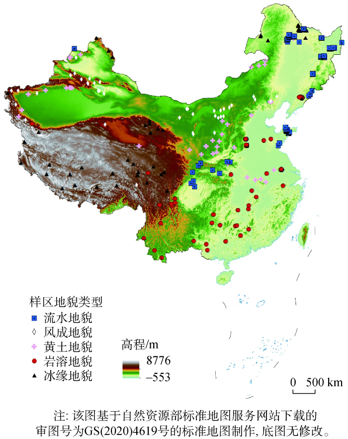
本研究采用的ASTER Global Digital Elevation Model(ASTER GDEM)数据是美国航空航天局(NASA)和日本经济产业省(METI)联合发布的全球数字高程数据产品。使用的DEM数据空间分辨率为30 m,为数字高程模型第二版本(ASTER GDEM V2),来源于地理空间数据云(
3 研究方法
本研究的具体技术路线如图2所示。
图2
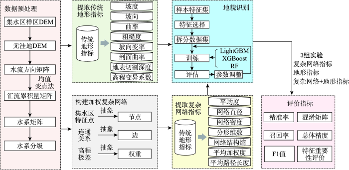
图2
集水区复杂网络的中国地貌类型识别研究技术路线
Fig. 2
Technical route of Chinese geomorphic type identification in complex network of catchment
首先是数据预处理,需要通过ArcGIS对DEM进行水文分析,主要包括:① 获取无洼地DEM; ② 建立水流方向矩阵;③ 建立汇流累积量矩阵; ④ 建立水系矩阵;⑤ 对水系进行分级。
其次,提取传统指标以描述和表达地貌形态。构建加权复杂网络后提取复杂网络指标,以构建了集水区内部的空间结构。
最后,进行地貌识别研究。将传统地形指标和复杂网络指标作为输入数据,借助3种机器学习方法对进行地貌识别,分别进行3组地貌识别实验:复杂网络指标、地形指标和复杂网络指标与地形指标结合,并借助各种评价指标进行精度分析,基于此探究此方案是否可以有效的应用于地貌识别研究中,检测集水区的多种指标结合策略在地貌识别中的可行性。
3.1 基于集水区的加权复杂网络的构建
在获取样区DEM数据后,利用ArcGIS的水文分析模块提取河网。随后利用要素折点转点工具,借助Strahler法对水系进行等级划分,以获取集水区地形特征要素和内在拓扑关系,并统计各个特征点之间连通线的高程属性值,计算高程极差作为网络边的权重,以构建集水区加权复杂网络,进行相关网络指标的提取从而对流域内部空间结构和组成元素进行定量描述。
3.1.1 最佳汇水阈值的确定
图3
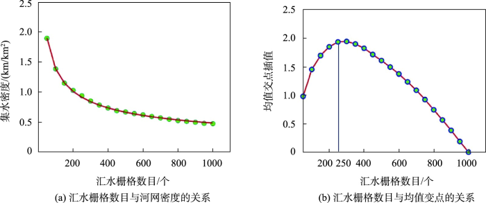
图3
集水区最佳汇水阈值提取分析示例
Fig. 3
Sample of optimal catchment threshold extraction analysis
3.1.2 集水区地形特征要素的提取与检验
本研究使用了目视解译法并基于等高线凸出的方向与河流流向相反,河流流向是等高线数值变小的方向的原理,消除平行河网、断线以及伪集水线。
将水文分析后获取的集水区地形特征点、线、面与DEM数据、等高线数据进行叠置,采用目视解译法进行人工调整(图4),以防止集水线出现冗余现象,从而模拟更加精确的集水区空间结构。
图4
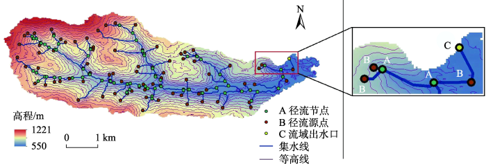
图4
集水区特征要素目视解译结果示例
Fig. 4
Examples of visual interpretation results of catchment feature elements
图5
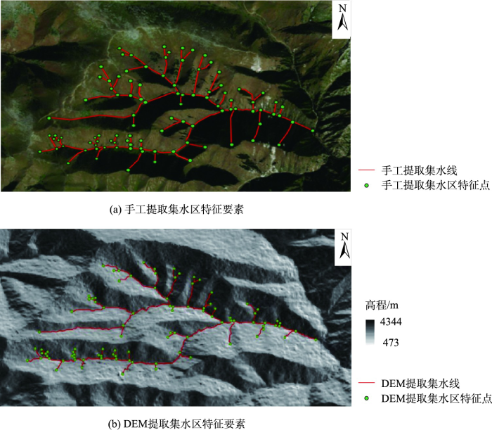
图5
手工与DEM提取集水区特征要素对比示例
Fig. 5
An example of comparison between manual and DEM extraction of catchment feature elements
由图5可以看出,两者提取的特征要素基本吻合,但仍存在些许误差,存在一些集水线提取不够完善导致特征要素缺失的问题。缺失的原因可能是ASTER GDEM生产过程中不能完全消除水系、云层及植被覆盖等对地表高程的影响。通过均值变点法确定不同地貌类型的最佳汇水阈值,可以提取出与实际地形吻合度较高的集水区特征要素。
3.1.3 集水区加权复杂网络的构建和复杂网络指标提取
利用Strahler河网分级法对集水区水系进行等级划分,将等级为1的集水区地形特征点选出为径流源点,等级不是1的集水区地形特征点选出为径流节点。这些特征点之间的有序组合与紧密相连的空间关系组成了地貌类型,且这些特征点都处于集水线上,因此,将集水区特征点与集水区特征线视为一个整体,提取集水线弧段的起点和终点以实现集水区特征点之间的连通关系。
图6
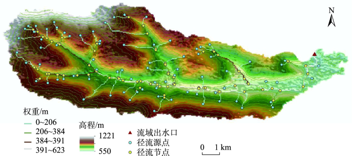
图6
集水区特征要素提取结果示例
Fig. 6
Sample diagram of catchment characteristic elements extraction
表1 复杂网络指标含义与相关计算方法
Tab. 1
| 指标名称 | 指标公式 | 公式参数说明 | 地学意义 | 公式编号 |
|---|---|---|---|---|
| 平均度 | 反映了集水区网络中某一类型节点所占的比重 | (1) | ||
| 平均加权度 | 反映了集水区复杂网络中某一类型节点对应边的权重情况 | (2) | ||
| 网络直径 | 表达了网络中各节点之间的距离 | (3) | ||
| 网络密度 | 在集水区复杂网络中,用网络中实际拥有的连线书与最多可能存在的连线总数之比表示 | 反映了集水区复杂网络中各节点间联络的紧密程度 | (4) | |
| 平均路径长度 | 对于一个集水区复杂网络,2个特征点之间存在多条集水区特征点连通且存在多种连通方式,则两个特征节点i与j之间的距离 | 反映了复杂的集水区网络中节点之间的分离程度 | (5) | |
网络结构熵 | 从整体角度衡量了集水区复杂网络系统演化的发展趋势 | (6) | ||
| 分形维数 | 对于任意一个集水区复杂网络,采用边长为r的正方形盒子覆盖,会出现一些盒子是包含图形,其余为空盒子的情况。随着盒子边长的增加,则包含图形的盒子数目逐渐减少。 | 刻画了集水区复杂网络系统的复杂程度,反映了集水区复杂网络系统的相似性 | (7) |
3.2 基于集水区的传统地形指标的提取
表2 地形指标含义和相关计算方法
Tab. 2
| 指标名称 | 指标公式 | 公式参数说明 | 地学含义 | 公式编号 |
|---|---|---|---|---|
| 坡向/° (Aspect) | 描述了集水区上坡面的朝向 | (8) | ||
| 坡度/% (slope) | 描述了集水区地表单元的陡缓程度 | (9) | ||
| 粗糙度 (SR) | 描述了集水区地势起伏的复杂程度 | (10) | ||
| 坡向变率 (SOA) | 描述了地表局部范围内坡向的变化情况 | (11) | ||
| 平面曲率 (Curve) | 集水区地形曲面在水平方向的曲率,描述了地面等高线的弯曲程度 | (12) | ||
| 剖面曲率 (SOS) | 描述了坡度的变化 程度 | (13) | ||
| 地表切割深度/m (SCD) | 反映了地表被侵蚀切割的情况 | (14) | ||
| 高程变异系数 (ECV) | 反映了地貌特征的差异性 | (15) |
3.3 基于机器学习算法的地貌识别应用研究
3.3.1 机器学习算法介绍
LightGBM(Light Gradient Boosting Machine)是一种新型的梯度Boosting决策树框架,采用单边梯度采样GOSS(Gradient-based One-side Sampling)和互补特征压缩(Exclusive Feature Bundling)2种算法进行迭代从而梯度提升,具有效率高、训练速度快和支持分布式等特点。它与其他梯度提升算法的关键区别在于使用了基于直方图的分割点搜索算法和具有深度限制的leaf-wise策略生长树。根据直方图的离散值,将每次收益最大的点选定为分裂点,同时,调节深度限制参数可以避免过度拟合,以此减少误差,提高了模型精度[46]。
XGBoost(eXtreme Gradient Boosting),是当前大规模并行的boosting tree的工具,亦是经过不断优化的分布式梯度提升库。为了更好的改善当前领域的决策树算法,它对目标函数项进行了二阶泰勒展开式的计算,并在目标函数中加入了正则项,具有灵活、高效且可移植的特点,可以很好地检测和处理缺失值,同时在一定程度上控制了模型的复杂度,进而防止了过度拟合[47]。
其目标函数原理是:
式中:
拆分决策树的叶子,寻找最佳树结构,可以进一步得到:
将目标函数式对
借助Python中的sklearn模块可以快速模拟构建XGBoost,并通过调参操作,不断优化模型效果。
随机森林(Random Forest,RF)是一种以决策树为基本单元,通过一种集成学习的思想将多棵树集成的机器学习算法。RF算法主要包含3个流程:① 从训练集中随机且有放回的抽取训练样本; ② 随机选取特征样本并形成决策树;③ 使用多棵决策树对选取的样本进行训练并做出分类和预测。它通过bootstrap sample重采样方法为每棵决策树生成独立的同分布训练样本集,最终的分类结果取决于所有决策树的投票。随机森林集成分类模型
式中:
同时,随机森林具有对高纬度、非线性数据的高适应能力,可以处理大量的输入样本并能有效避免过度拟合,从而提高分类器整体的识别精度。
LightGBM、XGBoost和RF在当前的机器学习算法中,具有较好的准确率,其特点包括:能够处理高维度的数据、提高预测和识别精度、避免过度拟合化等。近些年来,机器学习在理论与方法上都逐渐成熟,在回归分类等方面有良好的表现,因此也被广泛应用于不同的领域。本研究采用此3种机器学习的方法构建模型进行全国范围下的地貌识别,并对比得出更具有适用性的机器学习方法。
3.3.2 评价指标和实验设置
目前,在机器学习中有几种较为广泛使用的评价指标,即混淆矩阵(Confusion Matrix)、精准率(Precision)、召回率(Recall)、F1值、特征重要性评价、总体精度等。
混淆矩阵也称误差矩阵,是一种使用特定的矩阵形式来展现算法性能的可视化效果,在矩阵中,每一列代表的是预测的类别,每一行代表的是真实的类别,可以较为直观的显示其正确的预测结果。精准率表示正确识别结果与实际所得结果的比值,以此衡量正确值所占的比值。召回率R为正确预测地貌类型的样本数占该地貌类型实际数量的比例。根据这2种评估指标,为综合其性能,引入F1值(即数据集精确率和召回率的调和平均数)进行分析。特征重要性通过特征评价可以用数字可视化的形式,去呈现不同定量指标在此地貌识别中的贡献程度。特征
式中:
式中:
本研究主要根据上述实验获取的指标数据,借助机器学习模型,在每次评估中,200个集水区样区都被随机分成训练集和测试集2个部分,并采用交叉验证,将数据集80%的样本数据作为训练集进行训练计算,其余20%样本数据作为测试集进行精度验证并讨论相关实验结果。
4 结果及分析
4.1 3种机器学习识别精度对比
本文使用LightGBM、XGBoost、RF 3种机器学习方法对比分析所选取的指标(复杂网络指标与传统地形指标结合)对不同地貌类型的识别精度(图7)。为保证可以更加公平地识别各个机器学习模型的性能,数据的训练集和测试集的比例均取8:2。
图7
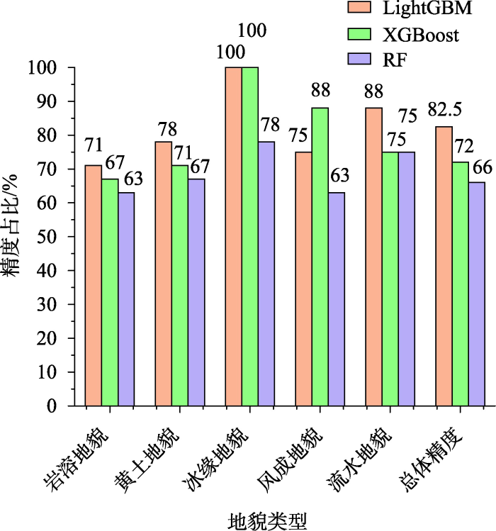
图7
3种机器学习的各种识别精度比较
Fig. 7
Comparison of various recognition accuracy of three kinds of machine learning
在不同地貌类型的识别中,冰缘地貌的识别效果最佳,LightGBM和XGBoost模型对冰缘地貌的识别效果均为100%,其次是流水地貌,其识别精度最高可达88%。在不同机器学习方法中,LightGBM识别效果最好,地貌的总体精度可以达到82.5%。相较于XGBoost模型方法,LightGBM模型方法对岩溶地貌(提升了4%)、黄土地貌(提升了7%)和流水地貌(提升了13%)的识别性能都有一定提升。由此可见,在全国范围下的集水区地貌识别方法中,LightGBM是一种相对较为高效、高精度的地貌识别方法。下面将LightGBM机器学习方法得到的复杂网络指标识别结果、地形指标识别结果、综合定量指标识别结果以及综合定量指标重要性讨论作为示例详细阐述。
4.2 复杂网络指标识别结果
基于在全国范围内提取的200个集水区构建集水区加权复杂网络,使用包括网络结构熵、平均路径长度、分形维数等共7个复杂网络定量指标作为基本特征向量对地貌体空间结构进行定量描述,并借助机器学习验证地貌识别结果的精度。
基于复杂网络的地形描述方法的地貌识别效果的总体精度可以达到77.5%,这表明引入复杂网络的相关理论对集水区地貌识别的适应性与科学性。根据识别结果构建出混淆矩阵如表3所示,可以观察到每种地貌类型识别效果的准确性,其中冰缘地貌类型的识别效果准确率为100%,风成地貌的识别精度达到88%,识别精度最低的地貌类型是岩溶地貌和黄土地貌,准确精度是71%。出现这种现象的原因可能是风成地貌表面较为平坦,其地形破碎化程度相对较低,相较于剩余的地貌类型更易区分。而岩溶地貌与黄土地貌在表面纹理特征、物理特性等方面来说具有一定的相似性,因此较易发生混淆,也导致此二类的地貌类型识别精度相对较低。此5种地貌类型的精确率和召回率均在70%以上,最高的可以达到100%,且F1值在70%以上。
表3 基于集水区加权复杂网络的LightGBM混淆矩阵
Tab. 3
| 岩溶地貌 | 黄土地貌 | 冰缘地貌 | 风成地貌 | 流水地貌 | 精准度/% | 召回率/% | F1值 | |
|---|---|---|---|---|---|---|---|---|
| 岩溶地貌 | 5 | 1 | 1 | 71 | 83 | 77 | ||
| 黄土地貌 | 1 | 5 | 1 | 71 | 83 | 77 | ||
| 冰缘地貌 | 8 | 100 | 80 | 90 | ||||
| 风成地貌 | 7 | 1 | 88 | 78 | 83 | |||
| 流水地貌 | 2 | 6 | 75 | 86 | 81 | |||
| 总体精度/% | 77.5 | |||||||
4.3 地形指标识别结果
根据在全国范围内提取的200个集水区,用于构建加权复杂网络,采用包括坡向变率、剖面曲率、高程变异系数等共8个地形定量指标作为基本特征向量,用于定量描述地表形态,如表4的混淆矩阵所示。用此模型的地貌识别效果的总体精度可以达到72.5%,每种地貌类型识别效果的精度均大于71%,其中冰缘地貌类型的识别效果准确率最高为88%,其次是黄土地貌和流水地貌,其识别精度均为86%。出现这种现象的原因可能是冰缘地貌多位于中国的西南区域(图1),分布相对集中,与其他地貌类型的相似度较低,更容易识别;而流水地貌(图1)分布较为散乱,与其他地貌的相似度更高;其中黄土地貌与岩溶地貌的表面起伏度相对较大,其地形破碎化程度相对较高,相较于剩余的地貌类型更易与其他地貌混淆。此5种地貌类型的精确率和召回率均在70%以上,最高的可以达到88%,且F1值在75%以上。
表4 基于地形指标的LightGBM混淆矩阵
Tab. 4
| 岩溶地貌 | 黄土地貌 | 冰缘地貌 | 风成地貌 | 流水地貌 | 精准度/% | 召回率/% | F1值 | |
|---|---|---|---|---|---|---|---|---|
| 岩溶地貌 | 5 | 1 | 1 | 71 | 83 | 77 | ||
| 黄土地貌 | 1 | 6 | 86 | 75 | 81 | |||
| 冰缘地貌 | 7 | 1 | 88 | 88 | 88 | |||
| 风成地貌 | 5 | 2 | 71 | 83 | 77 | |||
| 流水地貌 | 1 | 6 | 86 | 75 | 81 | |||
| 总体精度/% | 72.5 | |||||||
4.4 综合定量指标识别结果
为了提高模型的性能,本研究共设置了3组实验,即复杂网络指标、地形指标、复杂网络指标和地形指标,并借助机器学习的方法验证两种地形描述方法的结合是否可以提高基于集水区单元的地貌识别效果。
将上述2种类型的特征指标综合后共15个指标作为特征向量,所得混淆矩阵如表5所示,与上述2种识别方案对比,可以看出,此3种方法下识别精度最高的地貌类型都是冰缘地貌,识别的总体精度为82.5%,精准率和召回率都达到了70%,F1值基本处于74%~95%之间,相较于只对地形指标或复杂网络指标的识别精度有所提升。由此分析,基于复杂网络指标的识别方法和基于传统地形指标的识别方法存在一定的互补性,总体精度提升了约10%,这表明2种地形描述方法的结合(内部空间结构、拓扑关系和地表形态的结合)能够有效提高基于集水区单元的地貌识别,可为之后的地貌识别等提供参考依据。
表5 基于集水区综合指标的LightGBM混淆矩阵
Tab. 5
| 岩溶地貌 | 黄土地貌 | 冰缘地貌 | 风成地貌 | 流水地貌 | 精准度/% | 召回率/% | F1值 | |
|---|---|---|---|---|---|---|---|---|
| 岩溶地貌 | 5 | 2 | 71 | 83 | 77 | |||
| 黄土地貌 | 7 | 1 | 1 | 78 | 70 | 74 | ||
| 冰缘地貌 | 8 | 100 | 89 | 95 | ||||
| 风成地貌 | 1 | 6 | 1 | 75 | 86 | 81 | ||
| 流水地貌 | 1 | 7 | 88 | 88 | 88 | |||
| 总体精度/% | 82.5 | |||||||
5 讨论
5.1 综合定量指标重要性讨论
图8
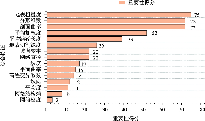
图8
集水区综合定量指标的重要性得分排序
Fig. 8
Ranking of importance scores of catchment comprehensive quantitative indicators
依据前人的研究,分析前述4个特征重要性排列靠前的原因:分形维数表征了网络的相似性与复杂性,分形维数的值越大,地形的复杂性越大,反之亦然。分形维数的增减会影响地形的复杂程度,进而揭示了地貌整体的复杂性,这与张捷[49]描述的分形理论在地貌学中的应用相吻合。
剖面曲率则描述了地形坡度的垂直变化,综合表达了地表的复杂特征与地貌特征的差异性,也符合本文所选取的第三级地貌类下10种成因类型地貌的特性,在此指标上可以对地貌进行有效的识别。
平均加权度是各个节点加权度的平均值,它描述了各节点在构成总体中的重要性,体现其差异性。本文中的权重为高程极差,平均加权度可以衡量地势起伏的复杂程度。
平均路径长度是集水区网络中全部节点两两之间距离的平均值,代表整个集水区网络内部结构的连通性、稳定性与复杂性。当路径长度过大时,维持此复杂网络的正常运转也需要消耗更多能量,此时其能量流动的连通性越低[25]。平均路径长度的高低变化会影响网络结构的连通性,进而揭示地貌的连通程度。
这些指标从地势起伏的复杂程度、地貌的差异性、连通性等方面,定量地描述了地貌体空间结构和内部组成,表征了集水区空间特征变化,能够更全面细致的反映地貌的本质特征。
此外,仍存在重要性评价偏低的指标,如网络密度、网络结构熵,林偲蔚[27]所得的重要性偏低的指标也是网络结构熵与网络密度,分析这两个指标重要性得分偏低的原因如下:网络密度表征了各节点之间联络的疏密程度,网络密度越大,则表明此复杂网络中的各个节点之间的联系越紧密,集水区河网密度越小,集水区被切割侵蚀程度越小,径流汇集慢,反之亦然。网络结构熵值的增减与地貌发育的强弱程度存在关联性,它是判断地貌演化发育程度的重要量化指标之一。网络结构熵的值越小,表明集水区受侵蚀的程度越大[25]。网络结构熵的重要性越高,说明在地貌识别中侵蚀强度发挥越重要的作用,而本文选取的地貌类型归属于第三级地貌类下10种成因类型地貌,此种地貌类是依据地貌形成的营力条件划分出的成因类型,而依据主成因营力作用方式(包含侵蚀作用)进行划分的是归属于第四级的地貌亚类,与本文所选的地貌类型不属于同一级别的地貌,与之不符,使此两种指标的重要性占比较低。
复杂网络指标如分形维数,是地学宏观思维方式和整体论的思想在地貌学研究中的展现。它们是在地貌学指标日趋精细化、局部化的过程中,出现的一类注重整体和全局空间关系的指标。这类指标有望广泛应用于地貌体内部空间关系的研究,地貌类型识别以及地貌分区工作的开展,也为之后的研究提供了更广泛的指标选择和指导。
5.2 研究结果的局限性
本研究引入复杂网络的理论知识,面向集水区基本地貌单元进行地貌识别,在基于传统地形指标与复杂网络指标的综合量化方法上取得了较好的识别效果,为地貌识别方法提供了新的研究视角,具有应用价值。然而,本研究仍存在以下局限性:
(1)本研究基于DEM数据选取多个地貌识别指标,这几种指标均属于使用较为常规、广泛的指标。下一步研究,可以考虑更加充分挖掘地貌信息,尤其是高分辨率的DEM信息,进一步细化对地貌形态量化的描述方式,并综合考虑指标的选择条件,如采用主成分分析等方法选取更优的指标组合,从而更加有效的对地貌进行定量描述。
(2)地形指标的提取会因DEM分辨率的不同而产生结果差异,以影响集水区地貌的量化结果,进而影响其识别精度,这也是数字地形分析中不可避免的问题。
6 结论
本文在全中国范围下选取200个实验样区,构建集水区加权复杂网络以此模拟地貌空间结构和提取地形特征,引入一系列定量指标对地貌体空间结构和地貌形态进行定量描述,使用LightGBM、XGBoost、RF等系列机器学习算法,构建训练模型,实现了基于集水区地貌单元对中国主要地貌类型的地貌识别。主要结论如下:
(1)地貌识别中复杂网络不同指标的重要性得分,表明了复杂网络具有空间信息的描述能力,能够为之后的研究提供理论支持。且两种不同地貌定量描述方法结合的地貌识别效果优于仅使用单一地貌定量描述方法下的地貌识别结果。与单一复杂网络指标和单一地形指标相比,两者组合的总体精度分别提高了5%和10%,表明从多种角度定量描述地貌特征,可以更加全面的获得地貌特征信息。
(2)引入复杂网络的分析工具,从整体的角度出发,剖析地貌的空间结构特征与内部拓扑关系,使用复杂网络的量化指标进行地貌识别,此结果表明总体精度的识别效果可以达到77.5%,优于基于地形指标的识别效果。说明了复杂网络在中国集水区的地貌识别研究中具有较好的适用性。复杂网络指标有望广泛应用于地貌识别、地貌分类等研究。
(3)对比了3种不同机器学习方法在基于集水区的地貌识别精度,根据结果分析可得LightGBM方法在此实验中体现出更高的性能,更适用于地貌识别。
(4)拓展了基于集水区的地貌识别方法的应用范畴,将研究区域拓展到了全国研究区,表明基于集水区地貌单元亦可以用于对中国主要的地貌类型进行识别工作,验证了基于集水区的地貌识别方法在不同地貌类型识别研究中的普适性和通用性。
本研究为基于集水区单元的地貌识别研究提供了参考,证实了复杂网络方法可以定量度量集水区的空间结构和拓扑关系,与传统的地形指标指数体系相结合,有助于获得更准确的地貌特征。未来的工作可以通过提高DEM分辨率、增加并筛选不同角度的指标、增加实验样区数量等以提高识别精度,以期望达到更好的效果。
参考文献
Chapter 9 landforms and landform elements in geomorphometry
[J].
Digital mapping
[M]//
基于空间结构模式匹配的褶皱地貌类型自动识别
[J].
DOI:10.3724/SP.J.1047.2016.01500
[本文引用: 2]

褶皱的自动化识别是构造解译、地貌类型划分、三维建模等工作的基础。目前,基于地形形态进行空间统计特征分析的地貌类型自动识别方法,难于满足以“对称重复”空间结构为特征的褶皱构造地貌的识别需要。本文以基于ARG的褶皱场景建模为切入点,利用形式文法定义不同褶皱类型的空间结构模式,形成了一种基于空间结构模式匹配的褶皱构造自动识别方法,进而有效地支持了褶皱地貌的自动化识别。该方法包括4个环节:(1)根据核部地层与横切剖面线提取原则,提取可能存在褶皱的场景条带;(2)基于邻接ARG建模方法对场景条带进行场景空间结构的建模与化简;(3)将化简后的邻接ARG模型表达成句子,并通过判别其能否由模式文法推导而来,实现针对不同褶皱构造模式的匹配识别;(4)基于识别出的褶皱场景进行山、谷的进一步判别,最终确定褶皱构造地貌类型。实验表明,本方法可以较为准确地识别出庐山北部山地区域的褶皱构造,并确定褶皱地貌类型。该方法基本解决了构造地貌类型的自动化识别问题,是对传统地貌形态划分方法的有效补充。
Automatic recognition of fold landform types based on spatial structure pattern matching
[J].
地理因子支持下的滑坡隐患点空间分布特征及识别研究
[J].
Spatial distribution and identification of hidden danger points of landslides based on geographical factors
[J].
青藏高原地貌形态总体特征的GIS识别分析
[J].
Recongnition of general topographic features in Qinghai- Tibet Plateau based on GIS
[J].
Automatic recognition of loess landforms using Random Forest method
[J].
利用最佳地形特征空间进行地貌形态自动识别——以西南地区为例
[J].
Topographic Automatic recognition of geomorphology using optimal terrain feature space: A Case Study of Southwest China
[J].
基本地貌形态数学定义的研究
[J].
A reseach on the mathematical definition of the basic landform shape
[J].
黄土高原数字地形分析研究进展
[J].
Progress of digital terrain analysis in the loess plateau of China
[J].
Landform classification based on landform geospatial structure - a case study on Loess Plateau of China
[J].
黄土沟谷特征点簇及其空间结构模型研究
[J].
DOI:10.13249/j.cnki.sgs.2015.09.1170
[本文引用: 1]
对黄土沟谷形态结构和发育演化起核心控制与标定作用的,是一系列具有自组织结构的特征点集。针对该特征点集,提出黄土沟谷特征点簇的概念,对其组织要素和基本特征进行了分析;研究创建一种采用非结构化、且能够有效表达拓扑结构与空间信息的黄土沟谷特征点簇空间结构模型;对基于DEM数据获取的一个典型黄土小流域沟谷特征点,运用创建的点簇模型建立了具体的黄土沟谷特征点簇;最后,以点簇中的特征点追溯查找为例,验证了所创建的黄土沟谷特征点簇的应用价值。
The loess gully feature points cluster and its spatial structure model
[J].
基于地貌结构与汇水特征的沟谷节点提取与分析——以陕北黄土高原为例
[J].
Extraction and analysis of gully nodes based on geomorphological structures and catchment characteristics: A case study in the loess plateau of North Shaanxi Province
[J].
Spatial structure characteristics detecting of landform based on improved 3D Lacunarity model
[J].
The landscape component approach to landscape evaluation
[J].
基于复杂网络的道路网拓扑结构信息度量
[J].
Quantitative measurements on topological structural information of road networks based on complex network analyses
[J].
基于复杂网络的官厅水库流域土地利用/覆被变化
[J].
DOI:10.11821/xb201201012
[本文引用: 1]
以北京西北部的官厅水库流域为研究区,以1978-2009 年之间的6 期Landsat 系列遥感影像为基础数据解译土地利用图。将土地利用/覆被变化(LUCC) 过程中的转移矩阵作为一种网络进行分析,土地利用类型是网络中的节点,不同地类之间的相互转化是网络的连线(边)。应用度、介数、网络平均最短路径等复杂网络方法,从土地利用系统整体的角度识别LUCC过程中的关键变化地类,评价土地利用系统的稳定性,分析生态环境变迁。研究结果表明:① 在近30 年的时间尺度上,旱地、天然草地和人工水域始终是转移矩阵中3 种关键变化地类,LUCC主要围绕这3 种地类进行;② 5 期转移矩阵网络的平均最短路径值均小于1.5,土地利用系统的活动性强、稳定性差,但五期网络的平均最短路径值总体上呈现增大趋势,土地利用系统向稳定方向发展;③ 近30 年来,自然生态系统不断被人工生态系统取代,自然生态系统中的天然草地面积减少了62.1%,未利用地的面积减少了65.1%。
Land use and land cover change in watershed of Guanting Reservoir based on complex network
[J].Based on six Landsat images from 1978 to 2009 of Guanting Reservoir located in northwest Beijing, this paper interprets land use maps. In the analysis of this paper, the transfer matrix of land use and cover change (LUCC) is studied as a network, among which land use types are nodes and conversions between different land use types are connections. From the overall perspective of land use system, the complex network methods of degree, betweenness and average shortest path are applied to identify the major changes in land use types, to assess stability of land use system and to analyse the changes from natural ecosystem to artificial ecosystem. The findings are shown as follows. First, in the time scale of recent 30 years, dry farming lands, natural grasslands and artificial water bodies are always the major changing land use types in transfer matrixes and the LUCC process has been dominated by these three land use types. Second, the average shortest path values of five transition matrix networks are all less than 1.5, indicating that land use system becomes more active yet less stable but the average shortest path values of these five networks present an increasing trend, indicating a more stable development of land use system. Third, in recent 30 years, natural ecosystem has been gradually replaced by artificial ecosystem, manifesting a reduction of 62.1% in natural grassland areas and a 65.1% reduction in waste land areas.
On the growth of Internet application flows: A complex network perspective
[C]//
Geomorphic coupling and sediment connectivity in an alpine catchment—Exploring sediment cascades using graph theory
[J].
Network theory and spatial rainfall connections: An interpretation
[J].
Complex networks and hydrologic applications
[M]//
Complex-network description of seismicity
[J].. The seismic data taken in California and Japan are mapped to growing random networks. It is shown in the undirected network picture that these earthquake networks are scale-free and small-work networks with the power-law connectivity distributions, the large values of the clustering coefficient, and the small values of the average path length. It is demonstrated how the present network approach reveals complexity of seismicity in a novel manner.\n
Graph theory in the geosciences
[J].
Complex networks in climate dynamics
[J].
复杂网络理论在黄土高原沟谷地貌特征研究中的应用
[J].
DOI:10.12082/dqxxkx.2021.200639
[本文引用: 5]
沟谷侵蚀是塑造黄土地表侵蚀形态的主要动力,沟谷的发育过程深刻地影响着黄土地貌的发育及演化。本文在黄土高原选择6个典型地貌样区,以样区的数字高程模型为基本数据源提取沟谷系统。将沟谷系统中的沟谷节点、沟谷源点和流域出水口点作为网络节点,网络节点之间的空间拓扑关系为边,高程差为权值,构建黄土高原沟谷加权复杂网络模型。对黄土沟谷地貌的节点特征和空间结构进行定量刻画和分析,得到黄土高原不同地貌类型网络特征的空间格局及其变化,并进一步映射地貌的发育过程及演化机理。研究结果表明:① 黄土高原沟谷加权网络的点强度累积概率分布呈指数分布,相关性系数皆达到0.80以上,该网络正处于向无标度网络转化的过渡期;② 样区从南到北,沟谷特征点的点强度值呈现逐渐减小的态势,且点强度的分布具有不对称性,沟谷右侧侵蚀强度较高,点强度分布较多;③ 平均路径长度和网络结构熵值在绥德一带最大,分别为30.94、6.31,并向南北两侧呈减少的趋势,网络密度值的变化与之相反;3个指标分别从网络结构的连通性、稳定性和紧密性反映了不同沟谷地貌类型的侵蚀程度以及地貌系统的演化机理;④ 网络指标与传统地貌指标的相关性系数均超过0.85,其可以科学、准确地表达地貌形态的复杂性及地貌的发育阶段,有望作为沟谷地貌地学特征研究的参数。该方法考虑了沟谷地貌的空间拓扑关系以及系统的整体性,为复杂表面形态的地貌研究提出了一种新的思路和方法。
Feature analysis of gully landforms in the loess plateau based on complex networks
[J].
流域地形景观系统的复杂网络描述
[J].
Complex network description of terrain landscape system on drainage basin
[J].
基于DEM小流域复杂网络的黄土高原地貌自动识别研究
[J].
DOI:10.12082/dqxxkx.2022.210449
[本文引用: 6]
地貌识别,对于人类建设,地质构造研究,环境治理等相关领域都有着重要意义。传统的基于像素单元或面向对象的地貌识别方法存在局限性。由于流域小单元具有表面形态的完整性,在地貌演化中具有明确的地理意义,基于流域小单元的地貌识别成为了该领域的一个新热点。然而,基于传统地形因子的地貌识别方法使用的因子往往较为单一或者在地学描述上存在重复性,目前尚无针对流域小单元进行空间结构描述和拓扑关系特征量化的地貌识别研究。基于此,本文基于DEM进行水文分析并通过坡谱方法解决了小流域稳定面积难以确定的问题,在黄土高原样区提取了181个稳定小流域。根据复杂网络理论和地貌学原理提出了流域加权复杂网络的概念和相应的8个定量指标用于流域空间结构的模拟和量化描述。最后采用了基于决策树的XGBoost机器学习算法进行地貌识别,实验对于黄土高原主要地貌类型的识别显现出较好的效果,Kappa系数为86.00%,总体精度达到了88.33%。对于地貌形态特征明显的地貌,复杂网络方法其顾及空间结构和拓扑特征的特性导致了其较高的识别性能,精度和召回率都在90%~100%之间。通过与前人的研究进行对比,其识别结果亦呈现出较高的精度,这些都验证了流域加权复杂网络是一种基于流域小单元地貌识别的高精度且有效的方法。
Geomorphological automatic recognition of loess plateau based on complex network of small watershed from DEM
[J].
基于DEM的喀斯特流域地貌类型的识别
[J].
Recognition based on Dem of geomorphologic type of Karst drainage
[J].
A cellular automata model for simulating the evolution of positive-negative terrains in a small loess watershed
[J].
In situ low-relief landscape formation as a result of river network disruption
[J].
面向子流域单元的典型黄土地貌分类研究
[J].
Classification of typical loess landforms in subcatchments
[J].
基于CART决策树的双尺度流域单元地貌分类研究——以北回归线(云南段)地区为例
[J].
Study on landform classification of dual-scale watershed units based on CART: A case study of the tropic of cancer (Yunnan section)
[J].
Regional topographic classification in the North Shaanxi Loess Plateau based on catchment boundary profiles
[J].Topographic classification and mapping are fundamental topics in geomorphology and have many promising applications. This study aimed to achieve landform classification using the catchment boundary profile (CBP) in the area of the North Shaanxi Province. CBPs were extracted, and seven indices were proposed and calculated to describe the profile features. Spatial maps of these indices were generated by interpolating 81 sample areas in the North Shaanxi Province of China. Finally, a topographic regional map was generated through multi-resolution segmentation after integrating the spatial maps of the seven indices. Results showed that the CBP indices were typical and representative to describe the terrain characteristics in the North Shaanxi Province and revealed their diverse spatial patterns. The investigated area was classified into 14 topographic units. The requirements of maximizing internal homogeneity while minimizing external homogeneity in terms of morphological characteristics were satisfied through the analysis of the terrain texture, topographic features, and land surface parameters. A comparison with the reference map showed that the regional classification differed from the geomorphologic map, given the different classification systems. However, the regional classification provided new knowledge of topographic features and spatial patterns in the macro scale. A comparison with other classification method indicated the advantage of the CBP-based method, which could distinguish the landforms of loess tableland, loess ridge, and loess hill that are the typical characteristics of loess landforms. The sensitivity analysis revealed that the differences in CBP indices, except for roughness and fractal dimension (FD) from different landforms, would increase with the digital elevation model (DEM) resolution becoming coarser, which indicates that the CBP-based method could be applied on a coarser resolution DEM if the differences of roughness and FD from different landforms could be identified at this coarse DEM level.
Drainage Basin object-based method for regional-scale landform classification: A case study of loess area in China
[J].
黄土地貌类型的坡谱自动识别分析
[J].
DOI:10.3724/SP.J.1047.2015.01234
[本文引用: 1]
地貌形态特征识别与分类,对生态环境、水文研究及地质构造分析等地学研究具有重要意义,已成为现代地貌学的一个研究热点。传统的统计模式识别方法精度较低,难以解决线性不可分的模式分类问题。人工方法虽然识别精度高,但因各人认知偏差导致的识别误差难以控制。人工神经网络作为一种动态信息处理系统,能有效解决线性不可分的地貌类型识别问题。坡谱是利用微观地形定量指标来反映宏观地形特征的有效方法,在地貌学研究中正受到广泛的关注。本文以陕北黄土高原8个不同地貌类型区的数字高程模型(DEM)为实验数据,以流域为分析单元,提取坡谱及其特征指标作为描述地形特征的定量因子,并通过BP神经网络的构建与学习,进行黄土地貌类型自动识别。实验结果表明,在8种地貌类型的样本数据中,第1次实验正确识别率平均值达70%;第2次和第3次实验中,去除相似度较高的峁状丘陵沟壑或峁梁状丘陵沟壑任一种地貌类型后,正确识别率平均提升为80%和85%。经Kappa系数验证,该方法能以DEM数据有效识别不同类型的黄土地貌。
A method of loess landform automatic recognition based on slope spectrum
[J].
基于随机森林的黄土地貌分类研究
[J].
DOI:10.12082/dqxxkx.2020.190247
[本文引用: 1]
地貌分类在指导人类建设活动的规模与布局中有着重要的意义。然而,传统的基于数字高程模型(DEM)的地貌分类方法使用的地形因子和考虑到的地貌特征往往比较单一。本文提出了一种基于流域单元的地貌分类方法,该方法考虑了流域单元的多方面特征,包括基本地形因子统计量、地形特征点线统计量、小流域特征和纹理特征。本研究首先基于DEM进行水文分析将研究区域划分成不同的小流域。然后利用数字地形分析提取29个不同方面的特征来表征流域的形态,并基于随机森林(RF)算法进行了特征选择和参数标定。RF是一种基于决策树算法的集成分类器,能有效地处理高维数据,分类精度高。最后选择训练集小流域对RF分类器进行训练,使用训练完成的分类器对整个研究区域的地貌进行分类,研究地貌分异的规律。该实验在我国陕北黄土高原典型黄土地貌区域的地貌分类中取得了较好的结果,结果表明不同的地貌之间存在明显的区域界线,特定的地貌类型在空间上表现出明显的聚集性。通过人工判读进行验证的分类精度达到了85%,Kappa系数为0.83。
Loess landform classification based on random forest
[J].
Multi-modal deep learning for landform recognition
[J].
Structure and contents of layered classification system of digital geomorphology for China
[J].This paper presents the structure and contents of a standardized layered classification system of digital geomorphology for China. This digital classification method combines landforms characteristics of morphology with genesis. A total of 15 categories of exogenic and endogenic forces are divided into two broad categories: morpho-genetic and morpho-structural landforms. Polygon patches are used to manage the morpho-genetic types, and solitary points, lines and polygons are used to manage the morpho-structural types. The classification method of digital morpho-genetic types can be divided into seven layers, i.e. basic morphology and altitude, genesis, sub-genesis, morphology, micro-morphology, slope and aspect, material and lithology. The method proposes combinations of matrix forms based on layered indicators. The attributes of every landform types are obtained from all or some of the seven layers. For the 15 forces categories, some classification indicators and calculation methods are presented for the basic morphology, the morphologic and sub-morphologic landforms of the morpho-genetic types. The solitary polygon, linear and point types of morpho-structural landforms are presented respectively. The layered classification method can meet the demands of scale-span geomorphologic mapping for the national primary scales from 1:500,000 to 1:1,000,000. The layers serve as classification indicators, and therefore can be added and reduced according to mapping demands, providing flexible expandability.
中国陆地1∶100万数字地貌分类体系研究
[J].地貌分类体系是地貌图研制的关键之一,本文在总结国内外地貌及分类研究的基础上,借鉴20世纪80年代的中国1∶100万地貌图制图规范,基于遥感影像、数字高程模型和计算机自动制图等技术条件,归纳总结了数字地貌分类过程中应遵循的几大原则,分析了它们之间的相互关系,讨论了数字地貌分类的各种指标:包括形态、成因、物质组成和年龄等,提出了中国陆地1∶100万数字地貌三等六级七层的数值分类方法,扩展了以多边形图斑反映形态成因类型,以点、线、面图斑共同反映形态结构类型的数字地貌数据组织方式,并详细划分了各成因类型的不同层次、不同级别的地貌类型。中国1∶100万数字地貌分类体系的研究,为遥感等多源数据的陆地地貌解析和制图提供了规范,也为《中华人民共和国地貌图集》的编制奠定了基础,同时为全国大、中比例尺地貌图的分类和编制研究提供了借鉴。
Research on the classification system of digital land geomorphology of 1∶1000000 in China
[J].
中国地貌区划理论与分区体系研究
[J].
DOI:10.11821/dlxb201905001
[本文引用: 1]
区划和类型是地貌学研究的两大核心内容。中国地貌区划已有诸多划分方案,比较而言,各种方案存在遴选指标不一、确定等级较少、反映特征各异、划分结果不同、成图尺度较小等不足。应中国地理国情普查等国家专项任务的需求,对较大尺度、多级地貌区划研究提出了新的要求。在梳理中国地貌区划的理论,包括板块构造与地貌圈特征、地貌形态与内外营力体系、地貌形态的类型组合与区域分异的基础上,基于2013年提出的中国地貌二级区划的新方案,归纳了全国多级地貌区划分的原则,提出了基于“大区—地区—区—亚区—小区”的全国五级地貌等级分区方案,建立了“大地构造控制下的地势阶梯特征—>区域宏观形态类型组合—>内外营力及基本形态类型组合—>区域内形态类型组合—>区域微地貌形态组合”的五级地貌分区指标体系,提出了五级地貌区划体系的命名规则和编码方式,构建了基于多源数据进行多级地貌区划单元精确定位的技术与方法,完成了全国1:25万尺度五级地貌区的划分,包括6个一级大区、36个二级地区、136个三级区、331个四级亚区、1500多个五级小区,并建立了全国地貌区划数据库。该研究对于促进中国区域地貌学的发展、基于地貌区划的应用研究等具有重要的指导意义。
Geomorphological regionalization theory system and division methodology of China
[J].Geomorphological regionalization and geomorphological types are the two core contents of geomorphologic research. Despite that there are many research achievements on the study of geomorphological regionalization, defects still exist such as the inconsistence of landform indicators, the small quantity of division grades, the disparity of geomorphological characteristics, the difference of mapping results and the small scale of zoning maps. New requirements for the national geomorphological regionalization therefore should be proposed at the request of national geo-information surveying and other national specific projects. On the basis of combing the theories of geomorphological regionalization in China including plate tectonics and crustal features, geomorphological features from endogenic and exogenic forces, and differences and regional differentiations of geomorphological types, a new research program of China's geomorphological regionalization with five grades, that is, major region, sub-major region, region, sub-region and small region, was proposed based on the previous geomorphological regionalization proposed in 2013 which divided the whole China into 6 major geomorphological regions and 37 districts. The major contents of the new geomorphological regionalization program can be summarized as follows: (1) principles of the national multi-grades geomorphological regionalization were established, (2) hierarchical indicator systems of the geomorphological regionalization (i.e. characteristics of the terrain ladder under the control of tectonic setting, combinations of regional macro-form types, combinations of endogenic and exogenic force and basic types of morphology, combinations of regional morphological types, combinations of regional micro-morphological types) were constructed, (3) naming rules and coding methods of the geomorphological regionalization were proposed, (4) precise positioning techniques and methods of the multi-grades geomorphological regionalization based on multi-source data were developed. On the basis of this new geomorphological regionalization project, the partitioning works of national five-grade geomorphological regionalization of 1:250,000 of China were successfully completed. And the geomorphological regionalization systems of the whole China were divided into 6 major regions, 36 sub-major regions, 136 regions, 331 sub-regions and more than 1500 small regions. In addition, the database and the management information system of the national geomorphological regionalization were then established. This research is of important guiding significance for promoting the development of China's regional geomorphology and the application research based on geomorphological regionalization.
Geomorphological regionalization theory system and division methodology of China
[J].Geomorphological regionalization (geomor-region) and geomorphological type (geomor-type) classification are two core components in the geomorphologic research. Although remarkable achievements have been made in the study of geomor-region, many deficiencies still exist, such as the inconsistency of landform indicators, the small quantity of division orders, disparities of geomorphological characteristics, differences of mapping results, and the small scale of zoning maps. Requirements for improved national geomor-regions are therefore needed for the purpose of an enhanced national geo-information system. Based on theories of geomor-region in China including plate tectonics, crustal features, endogenic and exogenic forced geomorphological features, and regional differentiations of geomor-type, a three-order (major-region, sub-region, and small-region) research program on China’s geomor-regions is proposed on the basis of previous 2013 geomor-region system. The major contents of the new geomor-region scheme are: (1) principles of the national multi-order geomor-regions; (2) hierarchical indicator systems of geomor-regions including characteristics of the terrain ladder under the control of tectonic setting, combinations of regional macro-form types, combinations of endogenic and exogenic forces and basic types of morphology, combinations of regional morphological types, and combinations of regional micro-morphological types; (3) naming rules and coding methods of geomor-regions; and (4) precise positioning techniques and methods of multi-order geomor-region divisions based on multi-source data. Using the new geomor-region theory and division methodology, the partition of national three-order geomor-regions of China was successfully constructed. The geomor-region system divided China into six first-order major-regions, 36 second-order sub-regions, and 136 third-order small-regions. In addition, a database and management information system of the national geomor-regions were established. This research has an important guiding significance for promoting the development of China’s regional geomorphology and for practical applications based on geomor-regions.
顾及空间特征的地形特征点提取方法
[J].
Terrain feature point extraction method considering spatial characteristics
[J].
基于DEM的沟谷特征点提取与分析
[J].
DOI:10.3724/SP.J.1047.2013.00061
[本文引用: 1]
沟谷特征点是反映沟谷地貌空间形态分布的重要点位,也是研究沟谷地貌演化过程与机理的关键要素。因此,对不同沟谷特征点的有效提取,是沟谷形态研究的重要基础。本文采用DEM及其在水文分析中的多种衍生数据,通过流向追踪、邻域特征判断等一系列方法,实现对径流节点、径流源点、汇流源点、潜在裂点与流域出口点的快速、准确提取。同时,对沟谷特征点进行有效分级,本文基于Strahler河流分级法建立了相应的分类标准,对沟谷特征点进行了自动分类。通过使用陕西省宜君典型样区5 m分辨率的DEM数据进行实验,发现新算法计算效率高,结果准确,对潜在裂点也进行了有效探测,验证了算法的有效性。最后,对特征点提取的数据影响进行了详细分析。
Extraction and analysis of gully feature points based on DEMs
[J].DOI:10.3724/SP.J.1047.2013.00061 URL [本文引用: 1]
地形坡度和高程变异系数在识别墨脱活动断裂带中的应用
[J].
Application of topographic slope and elevation variation coefficient in identifying the Motuo active fault zone
[J].
LightGBM: A highly efficient gradient boosting decision tree
[C]//
Effective intrusion detection system using XGBoost
[J].
Greedy function approximation: A gradient boosting machine
[J].
分形理论及其在地貌学中的应用──分形地貌学研究综述及展望
[J].
DOI:10.11821/yj1994030013
[本文引用: 1]
本文简介了分形的有关基本概念,回顾了分形理论在海岸、流水、喀斯特地貌等多种地貌类型和流域地貌发育的形态研究中,以及在地貌过程研究中的应用的新近成果,并提出了今后分形地貌学研究的五个主要方面.
Fractal geomorpholopy──review and propect
[J].
DOI:10.11821/yj1994030013
[本文引用: 1]
Fractal theory is a new techniques occurred with development of modern mathematics.Fractal geomorphological research is a new direction in geomorphology with the application of fractaI theoty. Fractal geomorpholoh can be considered to bi a new discipline to deal with the principle of orgins, development and distribution of relieves of the earth surface with special reference to fractaI theory. It focuses on the fractal geometric character of the distribution of geomorphological phenomena in space and time(phase space)and the related significanes in geomorphological process. In this paper, with a brief intruduction of the basic concepts of fractal, We reviewed the recent accomplishment of the application of fractal theory to morphological research of drainage basin and various types of geomorphology and to geomor-phological process researches including following aspects:1)coastal geomorphology,2)fluvial geomorphology,3) karst geomorphology,4)other types of geomorphology including glacial landforms,soilcovered land-scape and rock talus,5)mathematical-technique to generate fractal landscapes,6)landscape evolution,and 7)fractals in geomorphological process in phase space.Fractal theory prevides a new technique to find and to describe quantitative geometrical characters of chaotic,geomorphic phenomena, and variouskindfractal dimensions become type of geomorphic parameters. Fractal theory may be a possible way for geomorphologist to study and to explain the complex and chaotic earth surface processes and landforms. As for the future research of fractal geomorphology,the following issues still need further study:1) the genetic mechanisms of geomorphic fractal,ie,the relationship between geomorphic fractals and geomorphic conditions,2)the relationship between geomorphic fractal dimensions and geomorphic processes(phase),3)relationship between range-scale of geomorphic fractals and that of geomorphic processes,4)the further study of digital modeling of fractal landscape and its relation to physical geomorphic processes, 5)fractal characteristics of geomorphic phenomena in space and time and the possibility of geomorphic forecasting.
